176:
43:
279:
201:. Tracing out the Vedic history Thiru Kavithalam was the original name for the place however the name changed into Kabisthalam during medieval ages. It is located on the bank of river
236:
located in it. It is located in between
Kallanai Poombhuhar state highway. Gajendra Varadha temple is one of the pilgrimage (38th Divyasthala).
56:
320:
344:
339:
313:
97:
264:
306:
109:
42:
214:
233:
158:
8:
286:
194:
114:
294:
175:
290:
218:
142:
333:
71:
58:
213:
and 17 kilometres (11 mi) from
Thiruvaiyaru. It is the birthplace of
224:
Agriculture is the main occupation in this village. The main crops are
206:
198:
102:
253:
229:
210:
187:
154:
149:
278:
202:
190:
225:
232:, and vegetables. The village derives its name from the
331:
314:
205:, located 14 kilometres (8.7 mi) from
321:
307:
256:(31 August 2001). Retrieved on 2018-11-12.
265:District Development Authority, Thanjavur
174:
332:
273:
13:
345:Thanjavur district geography stubs
209:, 2 kilometres (1.2 mi) from
14:
356:
277:
41:
340:Villages in Thanjavur district
246:
1:
239:
293:. You can help Knowledge by
21:Village in Tamil Nadu, India
16:Village in Tamil Nadu, India
7:
252:G.K. Moopanar passes away.
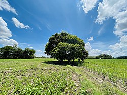
179:Paddy fields in Kabisthalam
47:River kaveri distributaries
10:
361:
272:
165:
148:
138:
133:
125:
120:
108:
96:
88:
52:
40:
33:
26:
215:Indian National Congress
234:Gajendra Varadha Temple
289:location article is a
180:
178:
139: • Official
186:is a village under
72:10.9486°N 79.2645°E
68: /
287:Thanjavur district
195:Thanjavur district
181:
126: • Total
302:
301:
173:
172:
352:
323:
316:
309:
281:
274:
257:
250:
83:
82:
80:
79:
78:
77:10.9486; 79.2645
73:
69:
66:
65:
64:
61:
45:
24:
23:
360:
359:
355:
354:
353:
351:
350:
349:
330:
329:
328:
327:
270:
261:
260:
251:
247:
242:
76:
74:
70:
67:
62:
59:
57:
55:
54:
48:
36:
29:
22:
17:
12:
11:
5:
358:
348:
347:
342:
326:
325:
318:
311:
303:
300:
299:
282:
268:
267:
259:
258:
244:
243:
241:
238:
219:G. K. Moopanar
171:
170:
167:
166:Telephone code
163:
162:
152:
146:
145:
140:
136:
135:
131:
130:
127:
123:
122:
118:
117:
112:
106:
105:
100:
94:
93:
90:
86:
85:
50:
49:
46:
38:
37:
34:
31:
30:
27:
20:
15:
9:
6:
4:
3:
2:
357:
346:
343:
341:
338:
337:
335:
324:
319:
317:
312:
310:
305:
304:
298:
296:
292:
288:
283:
280:
276:
275:
271:
266:
263:
262:
255:
249:
245:
237:
235:
231:
227:
222:
220:
216:
212:
208:
204:
200:
196:
192:
189:
185:
177:
168:
164:
160:
156:
153:
151:
147:
144:
141:
137:
132:
128:
124:
119:
116:
113:
111:
107:
104:
101:
99:
95:
91:
87:
81:
53:Coordinates:
51:
44:
39:
32:
25:
19:
295:expanding it
284:
269:
248:
223:
183:
182:
18:
184:Kabisthalam
75: /
28:Kabisthalam
334:Categories
240:References
207:Kumbakonam
199:Tamil Nadu
121:Population
103:Tamil Nadu
63:79°15′52″E
60:10°56′55″N
254:The Hindu
230:sugarcane
211:Papanasam
188:Papanasam
150:Time zone
134:Languages
115:Thanjavur
155:UTC+5:30
110:District
217:leader
203:Cauvery
169:91-4374
89:Country
35:Village
285:This
191:taluk
143:Tamil
129:7,300
98:State
92:India
291:stub
226:rice
221:.
197:in
193:in
159:IST
336::
228:,
322:e
315:t
308:v
297:.
161:)
157:(
84:\
Text is available under the Creative Commons Attribution-ShareAlike License. Additional terms may apply.

