88:
41:
929:
459:
316:
307:
203:
178:
325:
109:
339:
187:
95:
140:
441:
391:
407:
423:
248:
296:
266:
156:
129:
362:
348:
277:
468:
380:
167:
502:
230:
212:
496:
490:
508:
608:. As such, it occupies most of present-day Nevada, about half of Utah, large parts of eastern California and Oregon, and small parts of Idaho, Wyoming, and Baja California. The arid climate of this area ensures that none of the major lake basins are filled to overflowing, and thus no precipitation falling into them reaches the sea.
611:
Precipitation falling on the exterior of the Great Basin Divide does (if not evaporated or consumed on the way) reach the
Pacific Ocean, through a number of different channels. Roughly speaking, the area to the north and northeast of the Great Basin drains into the
724:
481:
953:
625:
717:
906:
523:
87:
710:
916:
448:
745:
633:
550:
369:
545:
948:
589:
540:
219:
911:
592:. It contains the watersheds of several large prehistoric and still-existing lakes, most notably
901:
771:
686:"Boundary Descriptions and Names of Regions, Subregions, Accounting Units and Cataloging Units"
237:
24:
8:
766:
255:
644:
Rivers), and various small rivers of southern
California and northern Baja California.
20:
801:
641:
781:
637:
535:
593:
577:
870:
796:
664:
621:
613:
430:
285:
69:
942:
891:
811:
629:
597:
581:
570:
117:
76:
16:
Hydrological divide in western United States bounding a large endorheic basin
40:
875:
821:
816:
786:
685:
45:
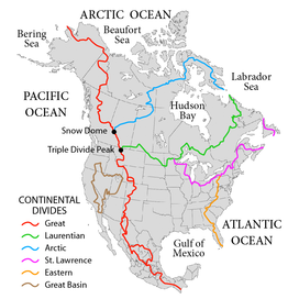
The Great Basin Divide (shown as the brown line on the map) demarcates the
847:
761:
733:
702:
617:
566:
46:
885:
865:
842:
837:
605:
601:
860:
526:
928:
565:
in the western United States is the ridgeline that separates the
620:. Likewise, the area to the south and southeast drains into the
501:
585:
495:
489:
507:
628:. The area west of the Great Basin is drained by the
576:The Great Basin is the largest set of contiguous
108:
940:
398:Peeler Lake
194:Columbia/Colorado
414:Crumbly Sp
718:
324:
732:
725:
711:
573:watershed, which completely surrounds it.
458:
338:
315:
306:
202:
177:
186:
94:
898:Baja California & other California
941:
422:
247:
706:
659:
657:
678:
665:"USA Lower 48 Triple Divide Points"
440:
390:
361:
13:
406:
347:
14:
965:
654:
276:
139:
927:
506:
500:
494:
488:
466:
457:
439:
421:
405:
389:
378:
360:
346:
337:
323:
314:
305:
294:
275:
264:
246:
228:
210:
201:
185:
176:
165:
154:
138:
127:
107:
93:
86:
39:
467:
954:Geography of the United States
1:
647:
624:, a good part of it via the
229:
211:
7:
882:Southern Mojave-Salton Sea
551:GPX (secondary coordinates)
10:
970:
857:Northern Mojave-Mono Lake
18:
925:
741:
546:GPX (primary coordinates)
521:Map all coordinates using
68:
60:
55:
37:
32:
529:Download coordinates as:
64:United States and Mexico
19:Not to be confused with
584:, including six entire
772:Great Salt Lake Desert
828:Central Nevada desert
541:GPX (all coordinates)
831:Oregon closed basins
793:Black Rock-Humboldt
578:endorheic watersheds
482:class=notpageimage|
25:Great Western Divide
834:Tulare-Buena Vista
486:Great Basin Divide
331:Klamath/ Sacramento
563:Great Basin Divide
33:Great Basin Divide
21:Great Divide Basin
936:
935:
917:San Jacinto River
808:Central Lahontan
802:Black Rock Desert
778:Escalante-Sevier
616:, mostly via the
513:
101:Columbia/ Klamath
82:
81:
961:
949:Drainage divides
931:
782:Escalante Desert
758:Great Salt Lake
753:Lower Bear River
750:Upper Bear River
727:
720:
713:
704:
703:
697:
696:
694:
693:
682:
676:
675:
673:
672:
667:. PeakBagger.com
661:
510:
504:
498:
492:
485:
470:
469:
461:
460:
451:
443:
442:
433:
425:
424:
415:
409:
408:
399:
393:
392:
382:
381:
372:
364:
363:
350:
349:
341:
340:
327:
326:
318:
317:
309:
308:
298:
297:
288:
279:
278:
268:
267:
258:
250:
249:
240:
232:
231:
222:
214:
213:
205:
204:
195:
189:
188:
180:
179:
169:
168:
158:
157:
142:
141:
131:
130:
121:
111:
110:
97:
96:
90:
72:
43:
30:
29:
969:
968:
964:
963:
962:
960:
959:
958:
939:
938:
937:
932:
923:
737:
731:
701:
700:
691:
689:
684:
683:
679:
670:
668:
663:
662:
655:
650:
636:of California (
594:Lake Bonneville
559:
558:
557:
556:
555:
516:
515:
514:
512:
484:
478:
477:
476:
475:
471:
463:
462:
454:
453:
452:
447:
444:
436:
435:
434:
429:
426:
418:
417:
416:
413:
410:
402:
401:
400:
397:
394:
386:
385:
383:
379:
375:
374:
373:
368:
365:
357:
356:
355:
351:
343:
342:
334:
333:
332:
328:
320:
319:
311:
310:
302:
301:
299:
295:
291:
290:
289:
284:
283:
280:
272:
271:
269:
265:
261:
260:
259:
254:
251:
243:
242:
241:
236:
233:
225:
224:
223:
218:
215:
207:
206:
198:
197:
196:
193:
190:
182:
181:
173:
172:
170:
166:
162:
161:
159:
155:
151:
150:
149:
147:
143:
135:
134:
132:
128:
124:
123:
122:
115:
112:
104:
103:
102:
98:
70:
51:
50:
28:
17:
12:
11:
5:
967:
957:
956:
951:
934:
933:
926:
924:
922:
921:
920:
919:
914:
909:
904:
896:
895:
894:
888:
880:
879:
878:
873:
871:Amargosa River
868:
863:
855:
854:North Lahontan
852:
851:
850:
845:
840:
832:
829:
826:
825:
824:
819:
814:
806:
805:
804:
799:
797:Humboldt River
791:
790:
789:
784:
776:
775:
774:
769:
764:
756:
755:
754:
751:
742:
739:
738:
730:
729:
722:
715:
707:
699:
698:
677:
652:
651:
649:
646:
634:Central Valley
622:Colorado River
614:Columbia River
554:
553:
548:
543:
538:
532:
519:
518:
517:
499:-overflow pt,
487:
480:
479:
473:
472:
465:
464:
456:
455:
446:
445:
438:
437:
431:Tehachapi Pass
428:
427:
420:
419:
412:
411:
404:
403:
396:
395:
388:
387:
384:
377:
376:
367:
366:
359:
358:
353:
352:
345:
344:
336:
335:
330:
329:
322:
321:
313:
312:
304:
303:
300:
293:
292:
282:
281:
274:
273:
270:
263:
262:
256:Paunsaugunt Pl
253:
252:
245:
244:
235:
234:
227:
226:
217:
216:
209:
208:
200:
199:
192:
191:
184:
183:
175:
174:
171:
164:
163:
160:
153:
152:
145:
144:
137:
136:
133:
126:
125:
114:
113:
106:
105:
100:
99:
92:
91:
85:
84:
83:
80:
79:
74:
66:
65:
62:
58:
57:
53:
52:
44:
38:
35:
34:
15:
9:
6:
4:
3:
2:
966:
955:
952:
950:
947:
946:
944:
930:
918:
915:
913:
910:
908:
905:
903:
902:Laguna Salada
900:
899:
897:
893:
892:Mojave Desert
889:
887:
884:
883:
881:
877:
874:
872:
869:
867:
864:
862:
859:
858:
856:
853:
849:
846:
844:
841:
839:
836:
835:
833:
830:
827:
823:
820:
818:
815:
813:
812:Truckee River
810:
809:
807:
803:
800:
798:
795:
794:
792:
788:
785:
783:
780:
779:
777:
773:
770:
768:
765:
763:
760:
759:
757:
752:
749:
748:
747:
744:
743:
740:
735:
728:
723:
721:
716:
714:
709:
708:
705:
687:
681:
666:
660:
658:
653:
645:
643:
639:
635:
631:
630:Klamath River
627:
623:
619:
615:
609:
607:
603:
599:
598:Lake Lahontan
595:
591:
587:
583:
582:North America
579:
574:
572:
571:Pacific Ocean
568:
564:
552:
549:
547:
544:
542:
539:
537:
534:
533:
531:
530:
525:
524:OpenStreetMap
522:
509:
503:
497:
491:
483:
450:
432:
371:
287:
257:
239:
221:
119:
89:
78:
77:North America
75:
73:
67:
63:
59:
54:
48:
42:
36:
31:
26:
22:
876:Mojave River
822:Walker River
817:Carson River
787:Sevier River
767:Jordan River
690:. Retrieved
680:
669:. Retrieved
610:
575:
562:
560:
528:
527:
520:
493:-triple pt,
120:divide)
71:Parent range
848:Tulare Lake
762:Weber River
734:Great Basin
642:San Joaquin
626:Green River
618:Snake River
567:Great Basin
449:Wasson Sill
370:I-80 Euer P
47:Great Basin
943:Categories
912:Lost River
907:Goose Lake
886:Salton Sea
866:Owens Lake
843:Tule River
838:Kern River
746:Bear River
736:watersheds
692:2010-06-07
688:. USGS.gov
671:2011-11-13
648:References
638:Sacramento
606:Salton Sea
604:, and the
602:Lake Manly
590:subregions
588:watershed
354:Pegleg Mtn
890:Southern
861:Mono Lake
569:from the
505:-border,
286:Delamar V
118:Silvies R
61:Countries
56:Geography
116:44.1°N (
474:31.46°N
632:, the
511:-other
640:and
586:USGS
561:The
238:I-70
220:I-80
148:Pass
146:Dean
580:of
536:KML
23:or
945::
656:^
600:,
596:,
726:e
719:t
712:v
695:.
674:.
49:.
27:.
Text is available under the Creative Commons Attribution-ShareAlike License. Additional terms may apply.

