892:"}},"text\/plain":{"en":{"":"coordinates of depicted place"}}},"{\"value\":{\"latitude\":50.3736,\"longitude\":-4.155,\"altitude\":null,\"precision\":0.0001,\"globe\":\"http:\\\/\\\/www.wikidata.org\\\/entity\\\/Q2\"},\"type\":\"globecoordinate\"}":{"text\/html":{"en":{"P9149":"50\u00b022'25.0"N, 4\u00b09'18.0"W"}},"text\/plain":{"en":{"P9149":"50\u00b022'25.0\"N, 4\u00b09'18.0\"W"}}},"{\"value\":{\"entity-type\":\"property\",\"numeric-id\":7787,\"id\":\"P7787\"},\"type\":\"wikibase-entityid\"}":{"text\/html":{"en":{"":"
464:"}},"text\/plain":{"en":{"":"author name string"}}},"{\"value\":\"Tony Atkin\",\"type\":\"string\"}":{"text\/html":{"en":{"P2093":"Tony Atkin"}},"text\/plain":{"en":{"P2093":"Tony Atkin"}}},"{\"value\":{\"entity-type\":\"property\",\"numeric-id\":3831,\"id\":\"P3831\"},\"type\":\"wikibase-entityid\"}":{"text\/html":{"en":{"":"
647:"}},"text\/plain":{"en":{"":"inception"}}},"{\"value\":{\"time\":\"+2006-04-28T00:00:00Z\",\"timezone\":0,\"before\":0,\"after\":0,\"precision\":11,\"calendarmodel\":\"http:\\\/\\\/www.wikidata.org\\\/entity\\\/Q1985727\"},\"type\":\"time\"}":{"text\/html":{"en":{"P571":"28 April 2006"}},"text\/plain":{"en":{"P571":"28 April 2006"}}}}": -->
681:
448:
43:
888:
260:
284:
322:
327:
87:
460:"}},"text\/plain":{"en":{"P2699":"https:\/\/www.geograph.org.uk\/profile\/1324"}}},"{\"value\":{\"entity-type\":\"property\",\"numeric-id\":2093,\"id\":\"P2093\"},\"type\":\"wikibase-entityid\"}":{"text\/html":{"en":{"":"
689:"}},"text\/plain":{"en":{"P7482":"file available on the internet"}}},"{\"value\":{\"entity-type\":\"property\",\"numeric-id\":137,\"id\":\"P137\"},\"type\":\"wikibase-entityid\"}":{"text\/html":{"en":{"":"
697:"}},"text\/plain":{"en":{"P137":"Geograph Britain and Ireland"}}},"{\"value\":{\"entity-type\":\"property\",\"numeric-id\":7384,\"id\":\"P7384\"},\"type\":\"wikibase-entityid\"}":{"text\/html":{"en":{"":"
468:"}},"text\/plain":{"en":{"":"object of statement has role"}}},"{\"value\":{\"entity-type\":\"item\",\"numeric-id\":33231,\"id\":\"Q33231\"},\"type\":\"wikibase-entityid\"}":{"text\/html":{"en":{"P3831":"
998:
603:"}},"text\/plain":{"en":{"":"copyright license"}}},"{\"value\":{\"entity-type\":\"item\",\"numeric-id\":19068220,\"id\":\"Q19068220\"},\"type\":\"wikibase-entityid\"}":{"text\/html":{"en":{"P275":"
559:"}},"text\/plain":{"en":{"":"copyright status"}}},"{\"value\":{\"entity-type\":\"item\",\"numeric-id\":50423863,\"id\":\"Q50423863\"},\"type\":\"wikibase-entityid\"}":{"text\/html":{"en":{"P6216":"
804:"}},"text\/plain":{"en":{"":"location of creation"}}},"{\"value\":{\"entity-type\":\"item\",\"numeric-id\":43382,\"id\":\"Q43382\"},\"type\":\"wikibase-entityid\"}":{"text\/html":{"en":{"P1071":"
685:"}},"text\/plain":{"en":{"":"source of file"}}},"{\"value\":{\"entity-type\":\"item\",\"numeric-id\":74228490,\"id\":\"Q74228490\"},\"type\":\"wikibase-entityid\"}":{"text\/html":{"en":{"P7482":"
848:"}},"text\/plain":{"en":{"":"captured with"}}},"{\"value\":{\"entity-type\":\"item\",\"numeric-id\":64072,\"id\":\"Q64072\"},\"type\":\"wikibase-entityid\"}":{"text\/html":{"en":{"P4082":"
693:"}},"text\/plain":{"en":{"":"operator"}}},"{\"value\":{\"entity-type\":\"item\",\"numeric-id\":1503119,\"id\":\"Q1503119\"},\"type\":\"wikibase-entityid\"}":{"text\/html":{"en":{"P137":"
896:"}},"text\/plain":{"en":{"":"heading"}}},"{\"value\":{\"amount\":\"+90\",\"unit\":\"http:\\\/\\\/www.wikidata.org\\\/entity\\\/Q28390\"},\"type\":\"quantity\"}":{"text\/html":{"en":{"P7787":"90
705:"}},"text\/plain":{"en":{"P7384":"229630"}}},"{\"value\":{\"entity-type\":\"property\",\"numeric-id\":973,\"id\":\"P973\"},\"type\":\"wikibase-entityid\"}":{"text\/html":{"en":{"":"
452:"}},"text\/plain":{"en":{"":"creator"}}},"{\"value\":{\"entity-type\":\"property\",\"numeric-id\":2699,\"id\":\"P2699\"},\"type\":\"wikibase-entityid\"}":{"text\/html":{"en":{"":"
844:
701:"}},"text\/plain":{"en":{"":"geograph.org.uk image ID"}}},"{\"value\":\"229630\",\"type\":\"string\"}":{"text\/html":{"en":{"P7384":"
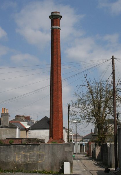
1015:== {{int:filedesc}} == {{Information |description={{en|1=Wyndham Lane Sewer Gas Chimney. This 60 foot high chimney was built in the 1880's to disperse gas and sewer smells way over the heads of the residents. It is the only one of its kind left in the ar
374:– You must give appropriate credit, provide a link to the license, and indicate if changes were made. You may do so in any reasonable manner, but not in any way that suggests the licensor endorses you or your use.
141:
Wyndham Lane Sewer Gas
Chimney. This 60 foot high chimney was built in the 1880's to disperse gas and sewer smells way over the heads of the residents. It is the only one of its kind left in the area.
53:
47:
98:
243:
66:
702:
686:
604:
560:
694:
849:
805:
469:
893:
889:
845:
801:
698:
682:
556:
465:
461:
453:
710:
706:
690:
644:
600:
457:
449:
1008:
607:"}},"text\/plain":{"en":{"P275":"Creative Commons Attribution-ShareAlike 2.0 Generic"}}}}": -->
713:"}},"text\/plain":{"en":{"P973":"https:\/\/www.geograph.org.uk\/photo\/229630"}}}}": -->
736:
630:
586:
253:
997:
992:
57:
42:
756:
291:
1060:
This file contains additional information, probably added from the digital camera or scanner used to create or digitize it.
381:
875:
831:
541:
934:
907:
859:
815:
764:
720:
570:
534:
521:
506:
779:
749:
654:
614:
479:
438:
1187:
337:
1063:
If the file has been modified from its original state, some details may not fully reflect the modified file.
852:"}},"text\/plain":{"en":{"P4082":"Canon EOS 350D"}}}}": -->
380:– If you remix, transform, or build upon the material, you must distribute your contributions under the
298:
on the
Geograph website for the photographer's contact details. The copyright on this image is owned by
472:"}},"text\/plain":{"en":{"P3831":"photographer"}}}}": -->
563:"}},"text\/plain":{"en":{"P6216":"copyrighted"}}}}": -->
1025:
The following pages on the
English Knowledge use this file (pages on other projects are not listed):
900:"}},"text\/plain":{"en":{"P7787":"90 degree"}}}}": -->
808:"}},"text\/plain":{"en":{"P1071":"Plymouth"}}}}": -->
106:
198:
1082:
1224:
786:
771:
513:
334:
182:
8:
1244:
278:
259:
303:
93:
428:
1072:
1304:
1234:
1206:
1089:
1129:
171:
161:
1254:
917:
869:
825:
730:
664:
624:
580:
489:
283:
1109:
1029:
295:
1099:
965:
Click on a date/time to view the file as it appeared at that time.
245:
1047:
131:
Wyndham Lane Sewer Gas
Chimney - geograph.org.uk - 229630.jpg
230:
50° 22′ 25″ N, 4° 09′ 18″ W
150:
81:
422:
Add a one-line explanation of what this file represents
1023:
1038:
963:
105:
Commons is a freely licensed media file repository.
631:
Creative
Commons Attribution-ShareAlike 2.0 Generic
605:
Creative
Commons Attribution-ShareAlike 2.0 Generic
1249:Flash did not fire, compulsory flash suppression
71:(446 × 640 pixels, file size: 70 KB, MIME type:
391:https://creativecommons.org/licenses/by-sa/2.0
86:
397:Creative Commons Attribution-Share Alike 2.0
315:
146:
128:
711:https:\/\/www.geograph.org.uk\/photo\/229630
458:https:\/\/www.geograph.org.uk\/profile\/1324
167:
156:
14:
897:
357:– to copy, distribute and transmit the work
1040:The following other wikis use this file:
787:https://www.geograph.org.uk/photo/229630
514:https://www.geograph.org.uk/profile/1324
252:View this and other nearby images on:
205:
117:
302:and is licensed for reuse under the
220:
956:
338:Attribution-Share Alike 2.0 Generic
326:
321:
306:Attribution-ShareAlike 2.0 license.
13:
1058:
427:
421:
312:
289:
135:
118:
64:
1329:
1065:
426:
1120:Date and time of data generation
1024:
412:
368:Under the following conditions:
333:This file is licensed under the
325:
320:
314:
282:
258:
244:
236:
85:
31:
21:
409:
136:
1035:
960:
737:file available on the internet
687:file available on the internet
408:
290:This image was taken from the
213:Wyndham Lane Sewer Gas Chimney
194:Wyndham Lane Sewer Gas Chimney
26:
1:
908:coordinates of depicted place
890:coordinates of depicted place
36:
1020:
757:Geograph Britain and Ireland
695:Geograph Britain and Ireland
535:object of statement has role
466:object of statement has role
434:Items portrayed in this file
274:
7:
1280:Focal plane resolution unit
1198:Date and time of digitizing
1055:
235:
10:
1334:
1044:Usage on fr.wikipedia.org
382:same or compatible license
125:
120:
1163:File change date and time
957:
16:
1272:Focal plane Y resolution
1264:Focal plane X resolution
923:50°22'25.0"N, 4°9'18.0"W
765:geograph.org.uk image ID
699:geograph.org.uk image ID
411:
348:
92:This is a file from the
41:
1288:Custom image processing
1014:
211:Tony Atkin /
192:Tony Atkin /
183:required by the license
149:
96:. Information from its
1083:Canon EOS 350D DIGITAL
993:02:05, 1 February 2010
296:this photograph's page
264:50.373600; -4.155000
99:description page there
46:Size of this preview:
1147:Horizontal resolution
1201:13:32, 28 April 2006
1166:13:32, 28 April 2006
1123:13:32, 28 April 2006
816:location of creation
802:location of creation
1171:Y and C positioning
1155:Vertical resolution
1069:Camera manufacturer
363:– to adapt the work
52:Other resolutions:
1314:Scene capture type
1309:Auto white balance
522:author name string
462:author name string
1321:
1320:
1094:1/500 sec (0.002)
1036:Global file usage
1018:
899:
615:copyright license
601:copyright license
420:
311:
310:
294:collection. See
269:
268:
218:
217:
186:
114:
113:
94:Wikimedia Commons
32:Global file usage
1325:
1267:3,958.7628865979
1179:Exposure Program
1066:
1048:Gaz d'égout
1005:
967:
945:
944:
939:
789:
784:
780:described at URL
774:
769:
759:
754:
707:described at URL
571:copyright status
557:copyright status
544:
539:
529:
526:
516:
511:
418:
404:
401:
398:
395:
392:
384:as the original.
346:
335:Creative Commons
329:
328:
324:
323:
318:
317:
304:Creative Commons
292:Geograph project
286:
279:
265:
262:
248:
247:
241:
240:
239:
233:
232:
221:
180:
152:
140:
132:
126:
110:
89:
88:
82:
76:
74:
61:
58:446 × 640 pixels
54:167 × 240 pixels
48:418 × 600 pixels
1333:
1332:
1328:
1327:
1326:
1324:
1323:
1322:
1275:3,954.233409611
1211:8.9657897949219
1054:
1034:
1026:
1019:
1011:
1003:
959:
958:
955:
954:
953:
952:
951:
950:
949:
948:
947:
946:
942:
940:
937:
928:
927:
926:
924:
914:
913:
912:
910:
887:
886:
885:
884:
883:
882:
881:
880:
878:
866:
865:
864:
862:
843:
842:
841:
840:
839:
838:
837:
836:
834:
822:
821:
820:
818:
799:
798:
797:
796:
795:
794:
793:
792:
791:
790:
785:
782:
776:
775:
770:
767:
761:
760:
755:
752:
743:
742:
741:
739:
727:
726:
725:
723:
680:
679:
678:
677:
676:
675:
674:
673:
671:
661:
660:
659:
657:
642:
641:
640:
639:
638:
637:
636:
635:
633:
621:
620:
619:
617:
598:
597:
596:
595:
594:
593:
592:
591:
589:
577:
576:
575:
573:
554:
553:
552:
551:
550:
549:
548:
547:
546:
545:
540:
537:
531:
530:
527:
524:
518:
517:
512:
509:
500:
499:
498:
496:
486:
485:
484:
482:
447:
446:
445:
444:
443:
441:
425:
424:
423:
406:
405:
402:
399:
396:
393:
390:
389:
347:
344:
341:
330:
307:
277:
263:
237:
228:
227:
224:Object location
219:
208:
201:
189:
162:geograph.org.uk
142:
130:
123:
116:
115:
104:
103:
102:is shown below.
78:
72:
70:
63:
62:
51:
12:
11:
5:
1331:
1319:
1318:
1315:
1311:
1310:
1307:
1301:
1300:
1297:
1293:
1292:
1291:Normal process
1289:
1285:
1284:
1281:
1277:
1276:
1273:
1269:
1268:
1265:
1261:
1260:
1257:
1251:
1250:
1247:
1241:
1240:
1237:
1231:
1230:
1227:
1221:
1220:
1217:
1213:
1212:
1209:
1203:
1202:
1199:
1195:
1194:
1191:
1184:
1183:
1182:Normal program
1180:
1176:
1175:
1172:
1168:
1167:
1164:
1160:
1159:
1156:
1152:
1151:
1148:
1144:
1143:
1140:
1136:
1135:
1132:
1125:
1124:
1121:
1117:
1116:
1113:
1106:
1105:
1102:
1096:
1095:
1092:
1086:
1085:
1080:
1076:
1075:
1070:
1057:
1053:
1052:
1051:
1050:
1037:
1033:
1032:
1022:
1017:
1016:
1013:
1009:
1006:
1000:
995:
990:
986:
985:
982:
979:
976:
973:
970:
962:
933:
932:
931:
930:
929:
925:
922:
920:
919:
918:
916:
915:
911:
906:
904:
903:
902:
901:
895:
891:
879:
876:Canon EOS 350D
874:
872:
871:
870:
868:
867:
863:
858:
856:
855:
854:
853:
851:
850:Canon EOS 350D
847:
835:
830:
828:
827:
826:
824:
823:
819:
814:
812:
811:
810:
809:
807:
803:
778:
777:
763:
762:
748:
747:
746:
745:
744:
740:
735:
733:
732:
731:
729:
728:
724:
721:source of file
719:
717:
716:
715:
714:
712:
708:
704:
700:
696:
692:
688:
684:
683:source of file
672:
669:
667:
666:
665:
663:
662:
658:
653:
651:
650:
649:
648:
646:
634:
629:
627:
626:
625:
623:
622:
618:
613:
611:
610:
609:
608:
606:
602:
590:
585:
583:
582:
581:
579:
578:
574:
569:
567:
566:
565:
564:
562:
558:
533:
532:
520:
519:
505:
504:
503:
502:
501:
497:
494:
492:
491:
490:
488:
487:
483:
478:
476:
475:
474:
473:
471:
467:
463:
459:
455:
451:
442:
437:
435:
432:
431:
430:
429:
417:
416:
413:
410:
388:
387:
386:
385:
375:
366:
365:
364:
358:
351:You are free:
342:
332:
331:
313:
309:
308:
287:
276:
273:
267:
266:
256:
250:
225:
216:
215:
209:
206:
203:
202:
197:
190:
187:
175:
174:
169:
165:
164:
158:
154:
153:
148:
144:
143:
133:
124:
122:
119:
112:
111:
90:
80:
79:
45:
40:
39:
34:
29:
24:
19:
9:
6:
4:
3:
2:
1330:
1316:
1313:
1312:
1308:
1306:
1305:White balance
1303:
1302:
1299:Auto exposure
1298:
1296:Exposure mode
1295:
1294:
1290:
1287:
1286:
1282:
1279:
1278:
1274:
1271:
1270:
1266:
1263:
1262:
1258:
1256:
1253:
1252:
1248:
1246:
1243:
1242:
1238:
1236:
1235:Metering mode
1233:
1232:
1228:
1226:
1225:Exposure bias
1223:
1222:
1218:
1216:APEX aperture
1215:
1214:
1210:
1208:
1207:Shutter speed
1205:
1204:
1200:
1197:
1196:
1192:
1189:
1186:
1185:
1181:
1178:
1177:
1173:
1170:
1169:
1165:
1162:
1161:
1157:
1154:
1153:
1149:
1146:
1145:
1141:
1138:
1137:
1133:
1131:
1127:
1126:
1122:
1119:
1118:
1114:
1111:
1108:
1107:
1103:
1101:
1098:
1097:
1093:
1091:
1090:Exposure time
1088:
1087:
1084:
1081:
1078:
1077:
1074:
1071:
1068:
1067:
1064:
1061:
1049:
1046:
1045:
1043:
1042:
1041:
1031:
1028:
1027:
1012:
1007:
1001:
999:
996:
994:
991:
988:
987:
983:
980:
977:
974:
971:
969:
968:
966:
936:
921:
909:
905:
877:
873:
861:
860:captured with
857:
846:captured with
833:
829:
817:
813:
788:
781:
773:
766:
758:
751:
738:
734:
722:
718:
670:28 April 2006
668:
656:
652:
632:
628:
616:
612:
588:
584:
572:
568:
543:
536:
523:
515:
508:
493:
481:
477:
440:
436:
433:
414:
407:
394:CC BY-SA 2.0
383:
379:
376:
373:
370:
369:
367:
362:
359:
356:
353:
352:
350:
349:
343:Attribution:
339:
336:
319:
305:
301:
297:
293:
288:
285:
281:
280:
272:
271:
261:
257:
255:
254:OpenStreetMap
251:
249:
231:
226:
223:
222:
214:
210:
204:
200:
196: /
195:
191:
184:
179:
177:
176:
173:
170:
166:
163:
159:
155:
151:28 April 2006
145:
139:
134:
127:
108:
101:
100:
95:
91:
84:
83:
77:
68:
67:Original file
59:
55:
49:
44:
38:
35:
33:
30:
28:
25:
23:
20:
18:
15:
1130:focal length
1079:Camera model
1062:
1059:
1039:
964:
961:File history
542:photographer
470:photographer
377:
371:
360:
354:
299:
270:
234:
212:
199:CC BY-SA 2.0
193:
137:
107:You can help
97:
65:
22:File history
1255:Color space
1139:Orientation
1010:GeographBot
587:copyrighted
561:copyrighted
378:share alike
372:attribution
178:Attribution
129:Description
1021:File usage
1002:446 × 640
978:Dimensions
528:Tony Atkin
495:some value
345:Tony Atkin
300:Tony Atkin
172:Tony Atkin
73:image/jpeg
27:File usage
1110:ISO speed
1030:Sewer gas
975:Thumbnail
972:Date/Time
655:inception
645:inception
275:Licensing
207:InfoField
188:InfoField
138:English:
1317:Standard
1174:Co-sited
1100:F-number
1056:Metadata
832:Plymouth
806:Plymouth
750:operator
691:operator
415:Captions
361:to remix
355:to share
340:license.
37:Metadata
1239:Pattern
1190:version
1004:(70 KB)
989:current
984:Comment
935:heading
894:heading
480:creator
450:creator
439:depicts
419:English
121:Summary
69:
1283:inches
1158:72 dpi
1150:72 dpi
1142:Normal
1112:rating
943:degree
898:degree
772:229630
703:229630
242:
168:Author
157:Source
1245:Flash
1134:38 mm
1128:Lens
1073:Canon
160:From
1259:sRGB
1193:2.21
1188:Exif
1104:f/16
981:User
403:true
400:true
147:Date
17:File
1115:400
941:90
507:URL
454:URL
938::
783::
768::
753::
538::
525::
510::
56:|
50:.
1229:0
1219:8
185:)
181:(
109:.
75:)
60:.

_heading:90.00&language=en)
