822:"}},"text\/plain":{"en":{"":"coordinates of the point of view"}}},"{\"value\":{\"latitude\":53.72592,\"longitude\":0.0408,\"altitude\":null,\"precision\":1.0e-5,\"globe\":\"http:\\\/\\\/www.wikidata.org\\\/entity\\\/Q2\"},\"type\":\"globecoordinate\"}":{"text\/html":{"en":{"P1259":"53\u00b043'33.31"N, 0\u00b02'26.88"E"}},"text\/plain":{"en":{"P1259":"53\u00b043'33.31\"N, 0\u00b02'26.88\"E"}}},"{\"value\":{\"entity-type\":\"property\",\"numeric-id\":7787,\"id\":\"P7787\"},\"type\":\"wikibase-entityid\"}":{"text\/html":{"en":{"":"
928:"}},"text\/plain":{"en":{"":"coordinates of depicted place"}}},"{\"value\":{\"latitude\":53.72601,\"longitude\":0.041,\"altitude\":null,\"precision\":1.0e-5,\"globe\":\"http:\\\/\\\/www.wikidata.org\\\/entity\\\/Q2\"},\"type\":\"globecoordinate\"}":{"text\/html":{"en":{"P9149":"53\u00b043'33.64"N, 0\u00b02'27.60"E"}},"text\/plain":{"en":{"P9149":"53\u00b043'33.64\"N, 0\u00b02'27.60\"E"}}},"{\"value\":{\"entity-type\":\"property\",\"numeric-id\":7787,\"id\":\"P7787\"},\"type\":\"wikibase-entityid\"}":{"text\/html":{"en":{"":"
890:"}},"text\/plain":{"en":{"":"inception"}}},"{\"value\":{\"time\":\"+2010-03-08T00:00:00Z\",\"timezone\":0,\"before\":0,\"after\":0,\"precision\":11,\"calendarmodel\":\"http:\\\/\\\/www.wikidata.org\\\/entity\\\/Q1985727\"},\"type\":\"time\"}":{"text\/html":{"en":{"P571":"8 March 2010"}},"text\/plain":{"en":{"P571":"8 March 2010"}}}}": -->
699:
305:
255:
924:
247:
319:
269:
340:
378:
383:
72:
524:"}},"text\/plain":{"en":{"P2699":"https:\/\/www.geograph.org.uk\/profile\/35313"}}},"{\"value\":{\"entity-type\":\"property\",\"numeric-id\":2093,\"id\":\"P2093\"},\"type\":\"wikibase-entityid\"}":{"text\/html":{"en":{"":"
723:"}},"text\/plain":{"en":{"P973":"https:\/\/www.geograph.org.uk\/photo\/1743160"}}},"{\"value\":{\"entity-type\":\"property\",\"numeric-id\":137,\"id\":\"P137\"},\"type\":\"wikibase-entityid\"}":{"text\/html":{"en":{"":"
707:"}},"text\/plain":{"en":{"P7482":"file available on the internet"}}},"{\"value\":{\"entity-type\":\"property\",\"numeric-id\":7384,\"id\":\"P7384\"},\"type\":\"wikibase-entityid\"}":{"text\/html":{"en":{"":"
512:"}},"text\/plain":{"en":{"":"object of statement has role"}}},"{\"value\":{\"entity-type\":\"item\",\"numeric-id\":33231,\"id\":\"Q33231\"},\"type\":\"wikibase-entityid\"}":{"text\/html":{"en":{"P3831":"
996:"}},"text\/plain":{"en":{"":"media type"}}},"{\"value\":\"image\\\/jpeg\",\"type\":\"string\"}":{"text\/html":{"en":{"P1163":"image\/jpeg"}},"text\/plain":{"en":{"P1163":"image\/jpeg"}}}}": -->
659:"}},"text\/plain":{"en":{"":"copyright license"}}},"{\"value\":{\"entity-type\":\"item\",\"numeric-id\":19068220,\"id\":\"Q19068220\"},\"type\":\"wikibase-entityid\"}":{"text\/html":{"en":{"P275":"
615:"}},"text\/plain":{"en":{"":"copyright status"}}},"{\"value\":{\"entity-type\":\"item\",\"numeric-id\":50423863,\"id\":\"Q50423863\"},\"type\":\"wikibase-entityid\"}":{"text\/html":{"en":{"P6216":"
703:"}},"text\/plain":{"en":{"":"source of file"}}},"{\"value\":{\"entity-type\":\"item\",\"numeric-id\":74228490,\"id\":\"Q74228490\"},\"type\":\"wikibase-entityid\"}":{"text\/html":{"en":{"P7482":"
528:"}},"text\/plain":{"en":{"":"author name string"}}},"{\"value\":\"JThomas\",\"type\":\"string\"}":{"text\/html":{"en":{"P2093":"JThomas"}},"text\/plain":{"en":{"P2093":"JThomas"}}}}": -->
1072:
516:"}},"text\/plain":{"en":{"P3831":"photographer"}}},"{\"value\":{\"entity-type\":\"property\",\"numeric-id\":2699,\"id\":\"P2699\"},\"type\":\"wikibase-entityid\"}":{"text\/html":{"en":{"":"
727:"}},"text\/plain":{"en":{"":"operator"}}},"{\"value\":{\"entity-type\":\"item\",\"numeric-id\":1503119,\"id\":\"Q1503119\"},\"type\":\"wikibase-entityid\"}":{"text\/html":{"en":{"P137":"
932:"}},"text\/plain":{"en":{"":"heading"}}},"{\"value\":{\"amount\":\"+67\",\"unit\":\"http:\\\/\\\/www.wikidata.org\\\/entity\\\/Q28390\"},\"type\":\"quantity\"}":{"text\/html":{"en":{"P7787":"67
826:"}},"text\/plain":{"en":{"":"heading"}}},"{\"value\":{\"amount\":\"+67\",\"unit\":\"http:\\\/\\\/www.wikidata.org\\\/entity\\\/Q28390\"},\"type\":\"quantity\"}":{"text\/html":{"en":{"P7787":"67
715:"}},"text\/plain":{"en":{"P7384":"1743160"}}},"{\"value\":{\"entity-type\":\"property\",\"numeric-id\":973,\"id\":\"P973\"},\"type\":\"wikibase-entityid\"}":{"text\/html":{"en":{"":"
508:"}},"text\/plain":{"en":{"":"creator"}}},"{\"value\":{\"entity-type\":\"property\",\"numeric-id\":3831,\"id\":\"P3831\"},\"type\":\"wikibase-entityid\"}":{"text\/html":{"en":{"":"
992:
520:"}},"text\/plain":{"en":{"":"URL"}}},"{\"value\":\"https:\\\/\\\/www.geograph.org.uk\\\/profile\\\/35313\",\"type\":\"string\"}":{"text\/html":{"en":{"P2699":"
288:
711:"}},"text\/plain":{"en":{"":"geograph.org.uk image ID"}}},"{\"value\":\"1743160\",\"type\":\"string\"}":{"text\/html":{"en":{"P7384":"
238:
430:– You must give appropriate credit, provide a link to the license, and indicate if changes were made. You may do so in any reasonable manner, but not in any way that suggests the licensor endorses you or your use.
252:
302:
83:
51:
712:
704:
660:
616:
728:
513:
993:
929:
925:
823:
819:
708:
700:
612:
525:
517:
509:
720:
521:
887:
724:
716:
656:
505:
1082:
1089:== {{int:filedesc}} == {{Information |description={{en|1=Withernsea Lifeboat Station}} |date=2010-03-08 |source=From |author= |permission= |other_
663:"}},"text\/plain":{"en":{"P275":"Creative Commons Attribution-ShareAlike 2.0 Generic"}}}}": -->
175:
754:
686:
642:
312:
262:
804:
1071:
1066:
347:
42:
1139:
This file contains additional information, probably added from the digital camera or scanner used to create or digitize it.
437:
569:
1003:
970:
943:
864:
837:
767:
738:
626:
592:
577:
562:
897:
797:
782:
670:
535:
494:
731:"}},"text\/plain":{"en":{"P137":"Geograph Britain and Ireland"}}}}": -->
393:
1142:
If the file has been modified from its original state, some details may not fully reflect the modified file.
1108:
436:– If you remix, transform, or build upon the material, you must distribute your contributions under the
354:
on the
Geograph website for the photographer's contact details. The copyright on this image is owned by
131:
619:"}},"text\/plain":{"en":{"P6216":"copyrighted"}}}}": -->
1099:
The following pages on the
English Knowledge use this file (pages on other projects are not listed):
936:"}},"text\/plain":{"en":{"P7787":"67 degree"}}}}": -->
830:"}},"text\/plain":{"en":{"P7787":"67 degree"}}}}": -->
91:
207:
1103:
789:
774:
584:
390:
191:
8:
334:
318:
268:
359:
78:
484:
164:
154:
1013:
953:
907:
847:
748:
680:
636:
545:
127:
339:
351:
1039:
Click on a date/time to view the file as it appeared at that time.
304:
254:
116:
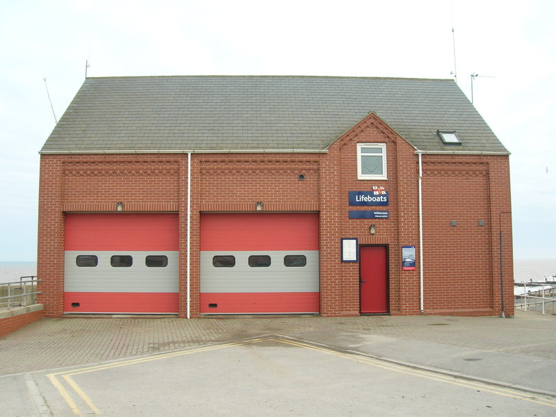
Withernsea
Lifeboat Station - geograph.org.uk - 1743160.jpg
52:
Withernsea_Lifeboat_Station_-_geograph.org.uk_-_1743160.jpg
289:
53° 43′ 34″ N, 0° 02′ 28″ E
239:
53° 43′ 33″ N, 0° 02′ 27″ E
143:
66:
478:
Add a one-line explanation of what this file represents
1126:
1097:
1117:
1037:
182:
Creative
Commons Attribution Share-alike license 2.0
90:
Commons is a freely licensed media file repository.
687:
Creative
Commons Attribution-ShareAlike 2.0 Generic
661:
Creative
Commons Attribution-ShareAlike 2.0 Generic
56:(800 × 600 pixels, file size: 95 KB, MIME type:
447:https://creativecommons.org/licenses/by-sa/2.0
71:
721:https:\/\/www.geograph.org.uk\/photo\/1743160
522:https:\/\/www.geograph.org.uk\/profile\/35313
453:Creative Commons Attribution-Share Alike 2.0
371:
170:
139:
113:
160:
149:
14:
933:
827:
413:– to copy, distribute and transmit the work
1119:The following other wikis use this file:
790:https://www.geograph.org.uk/photo/1743160
585:https://www.geograph.org.uk/profile/35313
311:View this and other nearby images on:
261:View this and other nearby images on:
214:
102:
358:and is licensed for reuse under the
279:
229:
1030:
394:Attribution-Share Alike 2.0 Generic
382:
377:
362:Attribution-ShareAlike 2.0 license.
13:
1137:
483:
477:
368:
345:
120:
103:
49:
1163:
1144:
482:
1098:
838:coordinates of the point of view
820:coordinates of the point of view
468:
424:Under the following conditions:
389:This file is licensed under the
381:
376:
370:
338:
317:
303:
295:
267:
253:
245:
70:
31:
21:
465:
121:
46:No higher resolution available.
1114:
1034:
755:file available on the internet
705:file available on the internet
464:
346:This image was taken from the
26:
1:
944:coordinates of depicted place
926:coordinates of depicted place
126:Withernsea Lifeboat Station,
36:
1094:
805:Geograph Britain and Ireland
729:Geograph Britain and Ireland
563:object of statement has role
510:object of statement has role
490:Items portrayed in this file
330:
7:
1134:
1109:Withernsea Lifeboat Station
294:
244:
222:Withernsea Lifeboat Station
203:Withernsea Lifeboat Station
10:
1168:
1123:Usage on www.wikidata.org
959:53°43'33.64"N, 0°2'27.60"E
853:53°43'33.31"N, 0°2'26.88"E
438:same or compatible license
110:
105:
1031:
16:
768:geograph.org.uk image ID
709:geograph.org.uk image ID
467:
404:
132:East Riding of Yorkshire
77:This is a file from the
41:
1088:
192:required by the license
142:
81:. Information from its
352:this photograph's page
323:53.726010; 0.041000
273:53.725920; 0.040800
84:description page there
1104:List of RNLI stations
220:JThomas /
201:JThomas /
1067:20:57, 5 March 2011
419:– to adapt the work
593:author name string
526:author name string
1155:
1154:
1115:Global file usage
1092:
935:
829:
671:copyright license
657:copyright license
476:
367:
366:
350:collection. See
328:
327:
278:
277:
227:
226:
195:
179:
176:Reusing this file
99:
98:
79:Wikimedia Commons
32:Global file usage
1159:
1145:
1079:
1041:
981:
980:
975:
875:
874:
869:
807:
802:
792:
787:
783:described at URL
777:
772:
717:described at URL
627:copyright status
613:copyright status
600:
597:
587:
582:
572:
567:
474:
460:
457:
454:
451:
448:
440:as the original.
402:
391:Creative Commons
385:
384:
380:
379:
374:
373:
360:Creative Commons
348:Geograph project
342:
335:
324:
321:
307:
306:
300:
299:
298:
292:
291:
280:
274:
271:
257:
256:
250:
249:
248:
242:
241:
230:
189:
173:
145:
125:
117:
111:
95:
74:
73:
67:
61:
59:
1167:
1166:
1162:
1161:
1160:
1158:
1157:
1156:
1133:
1113:
1100:
1093:
1085:
1077:
1033:
1032:
1029:
1028:
1027:
1026:
1025:
1024:
1023:
1022:
1020:
1010:
1009:
1008:
1006:
991:
990:
989:
988:
987:
986:
985:
984:
983:
982:
978:
976:
973:
964:
963:
962:
960:
950:
949:
948:
946:
923:
922:
921:
920:
919:
918:
917:
916:
914:
904:
903:
902:
900:
885:
884:
883:
882:
881:
880:
879:
878:
877:
876:
872:
870:
867:
858:
857:
856:
854:
844:
843:
842:
840:
817:
816:
815:
814:
813:
812:
811:
810:
809:
808:
803:
800:
794:
793:
788:
785:
779:
778:
773:
770:
761:
760:
759:
757:
745:
744:
743:
741:
698:
697:
696:
695:
694:
693:
692:
691:
689:
677:
676:
675:
673:
654:
653:
652:
651:
650:
649:
648:
647:
645:
633:
632:
631:
629:
610:
609:
608:
607:
606:
605:
604:
603:
602:
601:
598:
595:
589:
588:
583:
580:
574:
573:
568:
565:
556:
555:
554:
552:
542:
541:
540:
538:
503:
502:
501:
500:
499:
497:
481:
480:
479:
462:
461:
458:
455:
452:
449:
446:
445:
403:
400:
397:
386:
363:
333:
322:
296:
287:
286:
283:Object location
272:
246:
237:
236:
233:Camera location
228:
217:
210:
198:
155:geograph.org.uk
135:
115:
108:
101:
100:
89:
88:
87:is shown below.
63:
57:
55:
48:
47:
12:
11:
5:
1165:
1153:
1152:
1149:
1136:
1132:
1131:
1130:
1129:
1116:
1112:
1111:
1106:
1096:
1091:
1090:
1087:
1083:
1080:
1074:
1069:
1064:
1060:
1059:
1056:
1053:
1050:
1047:
1044:
1036:
1021:
1018:
1016:
1015:
1014:
1012:
1011:
1007:
1002:
1000:
999:
998:
997:
995:
969:
968:
967:
966:
965:
961:
958:
956:
955:
954:
952:
951:
947:
942:
940:
939:
938:
937:
931:
927:
915:
912:
910:
909:
908:
906:
905:
901:
896:
894:
893:
892:
891:
889:
863:
862:
861:
860:
859:
855:
852:
850:
849:
848:
846:
845:
841:
836:
834:
833:
832:
831:
825:
821:
796:
795:
781:
780:
766:
765:
764:
763:
762:
758:
753:
751:
750:
749:
747:
746:
742:
739:source of file
737:
735:
734:
733:
732:
730:
726:
722:
718:
714:
710:
706:
702:
701:source of file
690:
685:
683:
682:
681:
679:
678:
674:
669:
667:
666:
665:
664:
662:
658:
646:
641:
639:
638:
637:
635:
634:
630:
625:
623:
622:
621:
620:
618:
614:
591:
590:
576:
575:
561:
560:
559:
558:
557:
553:
550:
548:
547:
546:
544:
543:
539:
534:
532:
531:
530:
529:
527:
523:
519:
515:
511:
507:
498:
493:
491:
488:
487:
486:
485:
473:
472:
469:
466:
444:
443:
442:
441:
431:
422:
421:
420:
414:
407:You are free:
398:
388:
387:
369:
365:
364:
343:
332:
329:
326:
325:
315:
309:
284:
276:
275:
265:
259:
234:
225:
224:
218:
215:
212:
211:
206:
199:
196:
184:
183:
180:
168:
167:
162:
158:
157:
151:
147:
146:
141:
137:
136:
118:
109:
107:
104:
97:
96:
75:
65:
64:
45:
40:
39:
34:
29:
24:
19:
9:
6:
4:
3:
2:
1164:
1150:
1147:
1146:
1143:
1140:
1128:
1125:
1124:
1122:
1121:
1120:
1110:
1107:
1105:
1102:
1101:
1086:
1081:
1075:
1073:
1070:
1068:
1065:
1062:
1061:
1057:
1054:
1051:
1048:
1045:
1043:
1042:
1040:
1017:
1005:
1001:
972:
957:
945:
941:
911:
899:
895:
866:
851:
839:
835:
806:
799:
791:
784:
776:
769:
756:
752:
740:
736:
688:
684:
672:
668:
644:
640:
628:
624:
594:
586:
579:
571:
564:
549:
537:
533:
496:
492:
489:
470:
463:
450:CC BY-SA 2.0
439:
435:
432:
429:
426:
425:
423:
418:
415:
412:
409:
408:
406:
405:
399:Attribution:
395:
392:
375:
361:
357:
353:
349:
344:
341:
337:
336:
320:
316:
314:
313:OpenStreetMap
310:
308:
290:
285:
282:
281:
270:
266:
264:
263:OpenStreetMap
260:
258:
240:
235:
232:
231:
223:
219:
213:
209:
205: /
204:
200:
193:
188:
186:
185:
181:
177:
172:
169:
166:
163:
159:
156:
152:
148:
138:
133:
129:
124:
119:
112:
93:
86:
85:
80:
76:
69:
68:
62:
53:
44:
38:
35:
33:
30:
28:
25:
23:
20:
18:
15:
1141:
1138:
1118:
1038:
1035:File history
913:8 March 2010
570:photographer
514:photographer
433:
427:
416:
410:
355:
293:
243:
221:
208:CC BY-SA 2.0
202:
144:8 March 2010
122:
92:You can help
82:
50:
22:File history
1084:GeographBot
643:copyrighted
617:copyrighted
434:share alike
428:attribution
187:Attribution
114:Description
1148:_error
1095:File usage
1076:800 × 600
1052:Dimensions
1019:image/jpeg
1004:media type
994:media type
551:some value
171:Permission
134:, England.
128:Withernsea
58:image/jpeg
27:File usage
1127:Q65091121
1049:Thumbnail
1046:Date/Time
898:inception
888:inception
331:Licensing
216:InfoField
197:InfoField
123:English:
1135:Metadata
798:operator
725:operator
471:Captions
417:to remix
411:to share
396:license.
37:Metadata
1078:(95 KB)
1063:current
1058:Comment
971:heading
930:heading
865:heading
824:heading
775:1743160
713:1743160
599:JThomas
536:creator
506:creator
495:depicts
475:English
401:JThomas
356:JThomas
165:JThomas
106:Summary
54:
979:degree
934:degree
873:degree
828:degree
301:
251:
161:Author
150:Source
153:From
1055:User
459:true
456:true
140:Date
17:File
977:67
871:67
578:URL
518:URL
974::
868::
801::
786::
771::
596::
581::
566::
130:,
1151:0
194:)
190:(
178:)
174:(
94:.
60:)
Text is available under the Creative Commons Attribution-ShareAlike License. Additional terms may apply.
_heading:67.00&language=en)
_heading:67.00&language=en)
