839:"}},"text\/plain":{"en":{"":"coordinates of the point of view"}}},"{\"value\":{\"latitude\":53.7226,\"longitude\":-3.055,\"altitude\":null,\"precision\":0.0001,\"globe\":\"http:\\\/\\\/www.wikidata.org\\\/entity\\\/Q2\"},\"type\":\"globecoordinate\"}":{"text\/html":{"en":{"P1259":"53\u00b043'21.4"N, 3\u00b03'18.0"W"}},"text\/plain":{"en":{"P1259":"53\u00b043'21.4\"N, 3\u00b03'18.0\"W"}}},"{\"value\":{\"entity-type\":\"property\",\"numeric-id\":7787,\"id\":\"P7787\"},\"type\":\"wikibase-entityid\"}":{"text\/html":{"en":{"":"
907:"}},"text\/plain":{"en":{"":"coordinates of depicted place"}}},"{\"value\":{\"latitude\":53.7226,\"longitude\":-3.055,\"altitude\":null,\"precision\":0.0001,\"globe\":\"http:\\\/\\\/www.wikidata.org\\\/entity\\\/Q2\"},\"type\":\"globecoordinate\"}":{"text\/html":{"en":{"P9149":"53\u00b043'21.4"N, 3\u00b03'18.0"W"}},"text\/plain":{"en":{"P9149":"53\u00b043'21.4\"N, 3\u00b03'18.0\"W"}}},"{\"value\":{\"entity-type\":\"property\",\"numeric-id\":7787,\"id\":\"P7787\"},\"type\":\"wikibase-entityid\"}":{"text\/html":{"en":{"":"
491:"}},"text\/plain":{"en":{"":"author name string"}}},"{\"value\":\"Mr T\",\"type\":\"string\"}":{"text\/html":{"en":{"P2093":"Mr T"}},"text\/plain":{"en":{"P2093":"Mr T"}}},"{\"value\":{\"entity-type\":\"property\",\"numeric-id\":2699,\"id\":\"P2699\"},\"type\":\"wikibase-entityid\"}":{"text\/html":{"en":{"":"
801:"}},"text\/plain":{"en":{"":"inception"}}},"{\"value\":{\"time\":\"+2007-12-23T00:00:00Z\",\"timezone\":0,\"before\":0,\"after\":0,\"precision\":11,\"calendarmodel\":\"http:\\\/\\\/www.wikidata.org\\\/entity\\\/Q1985727\"},\"type\":\"time\"}":{"text\/html":{"en":{"P571":"23 December 2007"}},"text\/plain":{"en":{"P571":"23 December 2007"}}}}": -->
678:
284:
234:
276:
226:
903:
248:
319:
357:
362:
72:
499:"}},"text\/plain":{"en":{"P2699":"https:\/\/www.geograph.org.uk\/profile\/11222"}}},"{\"value\":{\"entity-type\":\"property\",\"numeric-id\":3831,\"id\":\"P3831\"},\"type\":\"wikibase-entityid\"}":{"text\/html":{"en":{"":"
686:"}},"text\/plain":{"en":{"P7482":"file available on the internet"}}},"{\"value\":{\"entity-type\":\"property\",\"numeric-id\":7384,\"id\":\"P7384\"},\"type\":\"wikibase-entityid\"}":{"text\/html":{"en":{"":"
503:"}},"text\/plain":{"en":{"":"object of statement has role"}}},"{\"value\":{\"entity-type\":\"item\",\"numeric-id\":33231,\"id\":\"Q33231\"},\"type\":\"wikibase-entityid\"}":{"text\/html":{"en":{"P3831":"
702:"}},"text\/plain":{"en":{"P137":"Geograph Britain and Ireland"}}},"{\"value\":{\"entity-type\":\"property\",\"numeric-id\":973,\"id\":\"P973\"},\"type\":\"wikibase-entityid\"}":{"text\/html":{"en":{"":"
638:"}},"text\/plain":{"en":{"":"copyright license"}}},"{\"value\":{\"entity-type\":\"item\",\"numeric-id\":19068220,\"id\":\"Q19068220\"},\"type\":\"wikibase-entityid\"}":{"text\/html":{"en":{"P275":"
594:"}},"text\/plain":{"en":{"":"copyright status"}}},"{\"value\":{\"entity-type\":\"item\",\"numeric-id\":50423863,\"id\":\"Q50423863\"},\"type\":\"wikibase-entityid\"}":{"text\/html":{"en":{"P6216":"
682:"}},"text\/plain":{"en":{"":"source of file"}}},"{\"value\":{\"entity-type\":\"item\",\"numeric-id\":74228490,\"id\":\"Q74228490\"},\"type\":\"wikibase-entityid\"}":{"text\/html":{"en":{"P7482":"
911:"}},"text\/plain":{"en":{"":"heading"}}},"{\"value\":{\"amount\":\"+337\",\"unit\":\"http:\\\/\\\/www.wikidata.org\\\/entity\\\/Q28390\"},\"type\":\"quantity\"}":{"text\/html":{"en":{"P7787":"337
843:"}},"text\/plain":{"en":{"":"heading"}}},"{\"value\":{\"amount\":\"+337\",\"unit\":\"http:\\\/\\\/www.wikidata.org\\\/entity\\\/Q28390\"},\"type\":\"quantity\"}":{"text\/html":{"en":{"P7787":"337
698:"}},"text\/plain":{"en":{"":"operator"}}},"{\"value\":{\"entity-type\":\"item\",\"numeric-id\":1503119,\"id\":\"Q1503119\"},\"type\":\"wikibase-entityid\"}":{"text\/html":{"en":{"P137":"
694:"}},"text\/plain":{"en":{"P7384":"652435"}}},"{\"value\":{\"entity-type\":\"property\",\"numeric-id\":137,\"id\":\"P137\"},\"type\":\"wikibase-entityid\"}":{"text\/html":{"en":{"":"
487:"}},"text\/plain":{"en":{"":"creator"}}},"{\"value\":{\"entity-type\":\"property\",\"numeric-id\":2093,\"id\":\"P2093\"},\"type\":\"wikibase-entityid\"}":{"text\/html":{"en":{"":"
590:
797:
690:"}},"text\/plain":{"en":{"":"geograph.org.uk image ID"}}},"{\"value\":\"652435\",\"type\":\"string\"}":{"text\/html":{"en":{"P7384":"
267:
217:
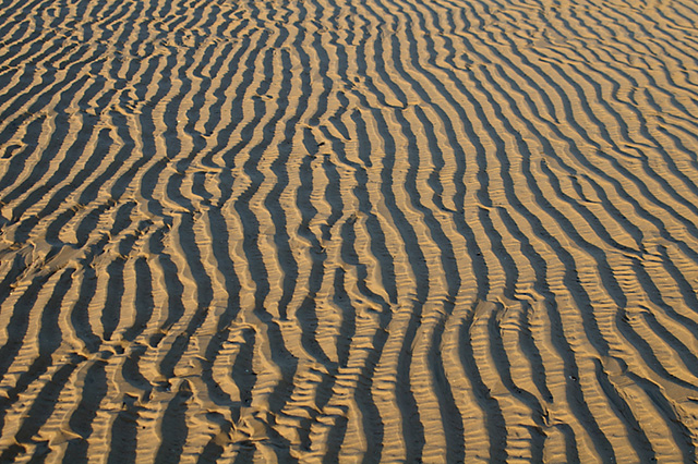
1030:== {{int:filedesc}} == {{Information |description={{en|1=Waves in the Sand All across Salter's Bank the variations of the sand texture are moulded by the action of the water to create many different patterns. Another is
409:– You must give appropriate credit, provide a link to the license, and indicate if changes were made. You may do so in any reasonable manner, but not in any way that suggests the licensor endorses you or your use.
281:
231:
691:
683:
639:
595:
699:
83:
51:
504:
908:
904:
840:
836:
687:
679:
591:
500:
492:
488:
496:
798:
707:
703:
695:
635:
484:
126:
Waves in the Sand. All across Salter's Bank the variations of the sand texture are moulded by the action of the water to create many different patterns. Another is
127:
1381:
1023:
642:"}},"text\/plain":{"en":{"P275":"Creative Commons Attribution-ShareAlike 2.0 Generic"}}}}": -->
1391:
710:"}},"text\/plain":{"en":{"P973":"https:\/\/www.geograph.org.uk\/photo\/652435"}}}}": -->
1031:
733:
665:
621:
291:
241:
1386:
768:
326:
1414:
This file contains additional information, probably added from the digital camera or scanner used to create or digitize it.
416:
576:
949:
922:
881:
854:
746:
717:
605:
569:
554:
541:
808:
776:
761:
649:
514:
473:
1158:
1063:
1012:
1007:
42:
1313:
1551:
372:
1298:
1417:
If the file has been modified from its original state, some details may not fully reflect the modified file.
1401:
1520:
1358:
415:– If you remix, transform, or build upon the material, you must distribute your contributions under the
333:
on the
Geograph website for the photographer's contact details. The copyright on this image is owned by
1303:
507:"}},"text\/plain":{"en":{"P3831":"photographer"}}}}": -->
1348:
1328:
598:"}},"text\/plain":{"en":{"P6216":"copyrighted"}}}}": -->
1396:
1044:
The following pages on the
English Knowledge use this file (pages on other projects are not listed):
915:"}},"text\/plain":{"en":{"P7787":"337 degree"}}}}": -->
847:"}},"text\/plain":{"en":{"P7787":"337 degree"}}}}": -->
1223:
1293:
1213:
91:
186:
1243:
1113:
1570:
1218:
1093:
561:
1173:
1083:
783:
753:
369:
170:
1376:
8:
1590:
313:
1426:
1338:
1248:
1193:
1098:
1068:
297:
247:
1660:
1308:
1153:
1128:
338:
78:
463:
1323:
1318:
1288:
1178:
1118:
1073:
1436:
1343:
1263:
1198:
1634:
1580:
1443:
1268:
1228:
1203:
1163:
1078:
159:
1670:
1483:
1333:
1273:
1258:
1253:
1238:
1143:
1138:
149:
932:
864:
818:
727:
659:
615:
524:
1600:
1188:
1183:
1133:
1103:
1048:
318:
1463:
1278:
1148:
1123:
1353:
1283:
1208:
1108:
330:
1680:
1453:
1168:
1058:
1053:
980:
Click on a date/time to view the file as it appeared at that time.
1233:
283:
233:
1088:
268:
53° 43′ 21″ N, 3° 03′ 18″ W
218:
53° 43′ 21″ N, 3° 03′ 18″ W
138:
66:
457:
Add a one-line explanation of what this file represents
1042:
1367:
978:
90:
Commons is a freely licensed media file repository.
666:
Creative
Commons Attribution-ShareAlike 2.0 Generic
640:
Creative
Commons Attribution-ShareAlike 2.0 Generic
56:(640 × 426 pixels, file size: 271 KB, MIME type:
1595:Flash did not fire, compulsory flash suppression
116:Waves in the Sand - geograph.org.uk - 652435.jpg
52:Waves_in_the_Sand_-_geograph.org.uk_-_652435.jpg
426:https://creativecommons.org/licenses/by-sa/2.0
71:
497:https:\/\/www.geograph.org.uk\/profile\/11222
432:Creative Commons Attribution-Share Alike 2.0
350:
134:
113:
708:https:\/\/www.geograph.org.uk\/photo\/652435
155:
144:
14:
912:
844:
392:– to copy, distribute and transmit the work
1369:The following other wikis use this file:
562:https://www.geograph.org.uk/profile/11222
784:https://www.geograph.org.uk/photo/652435
290:View this and other nearby images on:
240:View this and other nearby images on:
193:
102:
337:and is licensed for reuse under the
258:
208:
971:
373:Attribution-Share Alike 2.0 Generic
361:
356:
341:Attribution-ShareAlike 2.0 license.
13:
1412:
462:
456:
347:
324:
120:
103:
49:
1705:
1419:
461:
1474:Date and time of data generation
1159:Herringbone cross-stratification
1064:Amazon Basin (sedimentary basin)
1043:
855:coordinates of the point of view
837:coordinates of the point of view
447:
403:Under the following conditions:
368:This file is licensed under the
360:
355:
349:
317:
296:
282:
274:
246:
232:
224:
70:
31:
21:
1314:Society for Sedimentary Geology
444:
121:
46:No higher resolution available.
1364:
975:
734:file available on the internet
684:file available on the internet
443:
325:This image was taken from the
26:
1:
1299:Sedimentary Geology (journal)
923:coordinates of depicted place
905:coordinates of depicted place
36:
1039:
769:Geograph Britain and Ireland
700:Geograph Britain and Ireland
570:object of statement has role
501:object of statement has role
469:Items portrayed in this file
309:
273:
223:
7:
1562:Date and time of digitizing
1521:Adobe Photoshop CS2 Windows
1409:
1359:Template:Sedimentology-stub
10:
1710:
1644:Focal length in 35 mm film
1613:One-chip color area sensor
1373:Usage on fa.wikipedia.org
1304:Sedimentary basin analysis
417:same or compatible license
110:
105:
1527:File change date and time
1349:Winnowing (sedimentology)
1329:Thermal history modelling
1034:}} |date=2007-12-23 |sour
972:
16:
1224:Maturity (sedimentology)
938:53°43'21.4"N, 3°3'18.0"W
870:53°43'21.4"N, 3°3'18.0"W
747:geograph.org.uk image ID
688:geograph.org.uk image ID
446:
383:
77:This is a file from the
41:
1618:Custom image processing
1565:14:17, 23 December 2007
1477:14:17, 23 December 2007
1294:Sediment trap (geology)
1214:Marine flooding surface
1029:
171:required by the license
137:
81:. Information from its
1690:Subject distance range
1244:Perturbation (geology)
1114:Essaouira-Agadir basin
1008:16:45, 7 February 2011
331:this photograph's page
302:53.722600; -3.055000
252:53.722600; -3.055000
84:description page there
1530:11:42, 8 January 2008
1501:Horizontal resolution
1219:Matrix-supported rock
1094:Degradation (geology)
1639:Manual white balance
1174:Interference ripples
1084:Compaction (geology)
1535:Y and C positioning
1509:Vertical resolution
1437:PENTAX *ist DS
1427:PENTAX Corporation
1423:Camera manufacturer
1382:الگو:رسوبشناسی-خرد
398:– to adapt the work
1652:Scene capture type
1392:پیشروی (علوم زمین)
1339:Traction (geology)
1249:Pockmark (geology)
1194:Lenticular bedding
1099:Detritus (geology)
1069:Bajada (geography)
542:author name string
489:author name string
1697:
1696:
1448:1/200 sec (0.005)
1387:پسروی (علوم زمین)
1365:Global file usage
1309:Shields parameter
1154:Granule (geology)
1129:Fluting (geology)
1037:
914:
846:
650:copyright license
636:copyright license
455:
346:
345:
329:collection. See
307:
306:
257:
256:
206:
205:
201:Waves in the Sand
199:Mr T /
182:Waves in the Sand
180:Mr T /
174:
99:
98:
79:Wikimedia Commons
32:Global file usage
1701:
1543:Exposure Program
1420:
1324:Terrace Crossing
1020:
982:
960:
959:
954:
892:
891:
886:
824:23 December 2007
786:
781:
777:described at URL
771:
766:
756:
751:
704:described at URL
606:copyright status
592:copyright status
579:
574:
564:
559:
549:
546:
453:
439:
436:
433:
430:
427:
419:as the original.
381:
370:Creative Commons
364:
363:
359:
358:
353:
352:
339:Creative Commons
327:Geograph project
321:
314:
303:
300:
286:
285:
279:
278:
277:
271:
270:
259:
253:
250:
236:
235:
229:
228:
227:
221:
220:
209:
168:
140:
139:23 December 2007
125:
117:
111:
95:
74:
73:
67:
61:
59:
1709:
1708:
1704:
1703:
1702:
1700:
1699:
1698:
1408:
1363:
1319:Stream capacity
1289:Schiller layers
1179:Intra-arc basin
1119:Flame structure
1074:Basin modelling
1045:
1038:
1026:
1018:
974:
973:
970:
969:
968:
967:
966:
965:
964:
963:
962:
961:
957:
955:
952:
943:
942:
941:
939:
929:
928:
927:
925:
902:
901:
900:
899:
898:
897:
896:
895:
894:
893:
889:
887:
884:
875:
874:
873:
871:
861:
860:
859:
857:
834:
833:
832:
831:
830:
829:
828:
827:
825:
815:
814:
813:
811:
796:
795:
794:
793:
792:
791:
790:
789:
788:
787:
782:
779:
773:
772:
767:
764:
758:
757:
752:
749:
740:
739:
738:
736:
724:
723:
722:
720:
677:
676:
675:
674:
673:
672:
671:
670:
668:
656:
655:
654:
652:
633:
632:
631:
630:
629:
628:
627:
626:
624:
612:
611:
610:
608:
589:
588:
587:
586:
585:
584:
583:
582:
581:
580:
575:
572:
566:
565:
560:
557:
551:
550:
547:
544:
535:
534:
533:
531:
521:
520:
519:
517:
482:
481:
480:
479:
478:
476:
460:
459:
458:
441:
440:
437:
434:
431:
428:
425:
424:
382:
379:
376:
365:
342:
312:
301:
275:
266:
265:
262:Object location
251:
225:
216:
215:
212:Camera location
207:
196:
189:
177:
150:geograph.org.uk
130:
115:
108:
101:
100:
89:
88:
87:is shown below.
63:
57:
55:
48:
47:
12:
11:
5:
1707:
1695:
1694:
1691:
1687:
1686:
1683:
1677:
1676:
1673:
1667:
1666:
1663:
1657:
1656:
1653:
1649:
1648:
1645:
1641:
1640:
1637:
1631:
1630:
1627:
1623:
1622:
1621:Normal process
1619:
1615:
1614:
1611:
1610:Sensing method
1607:
1606:
1603:
1597:
1596:
1593:
1587:
1586:
1583:
1577:
1576:
1573:
1567:
1566:
1563:
1559:
1558:
1555:
1548:
1547:
1546:Normal program
1544:
1540:
1539:
1536:
1532:
1531:
1528:
1524:
1523:
1518:
1514:
1513:
1510:
1506:
1505:
1502:
1498:
1497:
1494:
1490:
1489:
1486:
1479:
1478:
1475:
1471:
1470:
1467:
1460:
1459:
1456:
1450:
1449:
1446:
1440:
1439:
1434:
1430:
1429:
1424:
1411:
1407:
1406:
1405:
1404:
1399:
1394:
1389:
1384:
1379:
1366:
1362:
1361:
1356:
1351:
1346:
1344:Tunguska Basin
1341:
1336:
1331:
1326:
1321:
1316:
1311:
1306:
1301:
1296:
1291:
1286:
1281:
1276:
1271:
1266:
1264:Retrogradation
1261:
1256:
1251:
1246:
1241:
1236:
1231:
1226:
1221:
1216:
1211:
1206:
1201:
1199:Liquefied flow
1196:
1191:
1186:
1181:
1176:
1171:
1166:
1161:
1156:
1151:
1146:
1141:
1136:
1131:
1126:
1121:
1116:
1111:
1106:
1101:
1096:
1091:
1086:
1081:
1076:
1071:
1066:
1061:
1056:
1051:
1041:
1036:
1035:
1028:
1024:
1021:
1015:
1010:
1005:
1001:
1000:
997:
994:
991:
988:
985:
977:
948:
947:
946:
945:
944:
940:
937:
935:
934:
933:
931:
930:
926:
921:
919:
918:
917:
916:
910:
906:
880:
879:
878:
877:
876:
872:
869:
867:
866:
865:
863:
862:
858:
853:
851:
850:
849:
848:
842:
838:
826:
823:
821:
820:
819:
817:
816:
812:
807:
805:
804:
803:
802:
800:
775:
774:
760:
759:
745:
744:
743:
742:
741:
737:
732:
730:
729:
728:
726:
725:
721:
718:source of file
716:
714:
713:
712:
711:
709:
705:
701:
697:
693:
689:
685:
681:
680:source of file
669:
664:
662:
661:
660:
658:
657:
653:
648:
646:
645:
644:
643:
641:
637:
625:
620:
618:
617:
616:
614:
613:
609:
604:
602:
601:
600:
599:
597:
593:
568:
567:
553:
552:
540:
539:
538:
537:
536:
532:
529:
527:
526:
525:
523:
522:
518:
513:
511:
510:
509:
508:
506:
502:
498:
494:
490:
486:
477:
472:
470:
467:
466:
465:
464:
452:
451:
448:
445:
423:
422:
421:
420:
410:
401:
400:
399:
393:
386:You are free:
377:
367:
366:
348:
344:
343:
322:
311:
308:
305:
304:
294:
288:
263:
255:
254:
244:
238:
213:
204:
203:
197:
194:
191:
190:
185:
178:
175:
163:
162:
157:
153:
152:
146:
142:
141:
136:
132:
131:
118:
109:
107:
104:
97:
96:
75:
65:
64:
45:
40:
39:
34:
29:
24:
19:
9:
6:
4:
3:
2:
1706:
1692:
1689:
1688:
1684:
1682:
1679:
1678:
1674:
1672:
1669:
1668:
1664:
1662:
1659:
1658:
1654:
1651:
1650:
1646:
1643:
1642:
1638:
1636:
1635:White balance
1633:
1632:
1629:Auto exposure
1628:
1626:Exposure mode
1625:
1624:
1620:
1617:
1616:
1612:
1609:
1608:
1604:
1602:
1599:
1598:
1594:
1592:
1589:
1588:
1584:
1582:
1581:Metering mode
1579:
1578:
1574:
1572:
1571:Exposure bias
1569:
1568:
1564:
1561:
1560:
1556:
1553:
1550:
1549:
1545:
1542:
1541:
1537:
1534:
1533:
1529:
1526:
1525:
1522:
1519:
1517:Software used
1516:
1515:
1511:
1508:
1507:
1503:
1500:
1499:
1495:
1492:
1491:
1487:
1485:
1481:
1480:
1476:
1473:
1472:
1468:
1465:
1462:
1461:
1457:
1455:
1452:
1451:
1447:
1445:
1444:Exposure time
1442:
1441:
1438:
1435:
1432:
1431:
1428:
1425:
1422:
1421:
1418:
1415:
1403:
1400:
1398:
1395:
1393:
1390:
1388:
1385:
1383:
1380:
1378:
1375:
1374:
1372:
1371:
1370:
1360:
1357:
1355:
1352:
1350:
1347:
1345:
1342:
1340:
1337:
1335:
1332:
1330:
1327:
1325:
1322:
1320:
1317:
1315:
1312:
1310:
1307:
1305:
1302:
1300:
1297:
1295:
1292:
1290:
1287:
1285:
1282:
1280:
1277:
1275:
1272:
1270:
1269:Rip-up clasts
1267:
1265:
1262:
1260:
1257:
1255:
1252:
1250:
1247:
1245:
1242:
1240:
1237:
1235:
1232:
1230:
1229:Micritisation
1227:
1225:
1222:
1220:
1217:
1215:
1212:
1210:
1207:
1205:
1204:Lithification
1202:
1200:
1197:
1195:
1192:
1190:
1187:
1185:
1182:
1180:
1177:
1175:
1172:
1170:
1167:
1165:
1164:Iglesia Basin
1162:
1160:
1157:
1155:
1152:
1150:
1147:
1145:
1142:
1140:
1137:
1135:
1132:
1130:
1127:
1125:
1122:
1120:
1117:
1115:
1112:
1110:
1107:
1105:
1102:
1100:
1097:
1095:
1092:
1090:
1087:
1085:
1082:
1080:
1079:Clastic wedge
1077:
1075:
1072:
1070:
1067:
1065:
1062:
1060:
1057:
1055:
1052:
1050:
1047:
1046:
1033:
1027:
1022:
1016:
1014:
1011:
1009:
1006:
1003:
1002:
998:
995:
992:
989:
986:
984:
983:
981:
951:
936:
924:
920:
883:
868:
856:
852:
822:
810:
806:
785:
778:
770:
763:
755:
748:
735:
731:
719:
715:
667:
663:
651:
647:
623:
619:
607:
603:
578:
571:
563:
556:
543:
528:
516:
512:
475:
471:
468:
449:
442:
429:CC BY-SA 2.0
418:
414:
411:
408:
405:
404:
402:
397:
394:
391:
388:
387:
385:
384:
378:Attribution:
374:
371:
354:
340:
336:
332:
328:
323:
320:
316:
315:
299:
295:
293:
292:OpenStreetMap
289:
287:
269:
264:
261:
260:
249:
245:
243:
242:OpenStreetMap
239:
237:
219:
214:
211:
210:
202:
198:
192:
188:
184: /
183:
179:
172:
167:
165:
164:
161:
158:
154:
151:
147:
143:
133:
129:
124:
119:
112:
93:
86:
85:
80:
76:
69:
68:
62:
53:
44:
38:
35:
33:
30:
28:
25:
23:
20:
18:
15:
1484:focal length
1433:Camera model
1416:
1413:
1368:
1334:Tidal bundle
1274:Rouse number
1259:Pseudomatrix
1254:Progradation
1239:Paleocurrent
1144:Gelifluction
1139:Fossil beach
979:
976:File history
577:photographer
505:photographer
412:
406:
395:
389:
334:
272:
222:
200:
187:CC BY-SA 2.0
181:
122:
92:You can help
82:
50:
22:File history
1601:Color space
1493:Orientation
1402:پیشروی دریا
1189:Lamalginite
1184:Isopach map
1134:Foreset bed
1104:Diachronism
1049:Aggradation
1025:GeographBot
622:copyrighted
596:copyrighted
413:share alike
407:attribution
166:Attribution
114:Description
1693:Close view
1671:Saturation
1397:پسروی دریا
1279:Sand sheet
1149:Grain flow
1124:Flaser bed
1040:File usage
1017:640 × 426
993:Dimensions
530:some value
58:image/jpeg
27:File usage
1681:Sharpness
1464:ISO speed
1354:ZTR index
1284:Sand wave
1209:Lithotope
1109:Diamicton
990:Thumbnail
987:Date/Time
809:inception
799:inception
310:Licensing
195:InfoField
176:InfoField
123:English:
1661:Contrast
1655:Standard
1538:Co-sited
1454:F-number
1410:Metadata
1169:Illuvium
1059:Allochem
1054:Aleurite
1019:(271 KB)
762:operator
696:operator
450:Captions
396:to remix
390:to share
375:license.
37:Metadata
1585:Pattern
1554:version
1377:کانرفت
1234:Molasse
1004:current
999:Comment
950:heading
909:heading
882:heading
841:heading
515:creator
485:creator
474:depicts
454:English
106:Summary
54:
1685:Normal
1675:Normal
1665:Normal
1512:72 dpi
1504:72 dpi
1496:Normal
1466:rating
1089:Cutans
1032:652440
958:degree
913:degree
890:degree
845:degree
754:652435
692:652435
280:
230:
156:Author
145:Source
128:652440
1647:64 mm
1591:Flash
1488:43 mm
1482:Lens
1458:f/7.1
148:From
1605:sRGB
1557:2.21
1552:Exif
996:User
956:337
888:337
548:Mr T
438:true
435:true
380:Mr T
335:Mr T
160:Mr T
135:Date
17:File
1469:200
555:URL
493:URL
953::
885::
780::
765::
750::
573::
558::
545::
1575:0
173:)
169:(
94:.
60:)
Text is available under the Creative Commons Attribution-ShareAlike License. Additional terms may apply.
_heading:337.00&language=en)
_heading:337.00&language=en)
