831:"}},"text\/plain":{"en":{"":"coordinates of the point of view"}}},"{\"value\":{\"latitude\":51.10198,\"longitude\":-0.774,\"altitude\":null,\"precision\":1.0e-5,\"globe\":\"http:\\\/\\\/www.wikidata.org\\\/entity\\\/Q2\"},\"type\":\"globecoordinate\"}":{"text\/html":{"en":{"P1259":"51\u00b06'7.13"N, 0\u00b046'26.40"W"}},"text\/plain":{"en":{"P1259":"51\u00b06'7.13\"N, 0\u00b046'26.40\"W"}}},"{\"value\":{\"entity-type\":\"property\",\"numeric-id\":7787,\"id\":\"P7787\"},\"type\":\"wikibase-entityid\"}":{"text\/html":{"en":{"":"
899:"}},"text\/plain":{"en":{"":"coordinates of depicted place"}}},"{\"value\":{\"latitude\":51.10153,\"longitude\":-0.7739,\"altitude\":null,\"precision\":1.0e-5,\"globe\":\"http:\\\/\\\/www.wikidata.org\\\/entity\\\/Q2\"},\"type\":\"globecoordinate\"}":{"text\/html":{"en":{"P9149":"51\u00b06'5.51"N, 0\u00b046'26.04"W"}},"text\/plain":{"en":{"P9149":"51\u00b06'5.51\"N, 0\u00b046'26.04\"W"}}},"{\"value\":{\"entity-type\":\"property\",\"numeric-id\":7787,\"id\":\"P7787\"},\"type\":\"wikibase-entityid\"}":{"text\/html":{"en":{"":"
483:"}},"text\/plain":{"en":{"":"author name string"}}},"{\"value\":\"Colin Smith\",\"type\":\"string\"}":{"text\/html":{"en":{"P2093":"Colin Smith"}},"text\/plain":{"en":{"P2093":"Colin Smith"}}},"{\"value\":{\"entity-type\":\"property\",\"numeric-id\":2699,\"id\":\"P2699\"},\"type\":\"wikibase-entityid\"}":{"text\/html":{"en":{"":"
793:"}},"text\/plain":{"en":{"":"inception"}}},"{\"value\":{\"time\":\"+2009-05-10T00:00:00Z\",\"timezone\":0,\"before\":0,\"after\":0,\"precision\":11,\"calendarmodel\":\"http:\\\/\\\/www.wikidata.org\\\/entity\\\/Q1985727\"},\"type\":\"time\"}":{"text\/html":{"en":{"P571":"10 May 2009"}},"text\/plain":{"en":{"P571":"10 May 2009"}}}}": -->
670:
276:
226:
268:
218:
895:
240:
311:
349:
354:
67:
491:"}},"text\/plain":{"en":{"P2699":"https:\/\/www.geograph.org.uk\/profile\/3972"}}},"{\"value\":{\"entity-type\":\"property\",\"numeric-id\":3831,\"id\":\"P3831\"},\"type\":\"wikibase-entityid\"}":{"text\/html":{"en":{"":"
678:"}},"text\/plain":{"en":{"P7482":"file available on the internet"}}},"{\"value\":{\"entity-type\":\"property\",\"numeric-id\":137,\"id\":\"P137\"},\"type\":\"wikibase-entityid\"}":{"text\/html":{"en":{"":"
686:"}},"text\/plain":{"en":{"P137":"Geograph Britain and Ireland"}}},"{\"value\":{\"entity-type\":\"property\",\"numeric-id\":7384,\"id\":\"P7384\"},\"type\":\"wikibase-entityid\"}":{"text\/html":{"en":{"":"
495:"}},"text\/plain":{"en":{"":"object of statement has role"}}},"{\"value\":{\"entity-type\":\"item\",\"numeric-id\":33231,\"id\":\"Q33231\"},\"type\":\"wikibase-entityid\"}":{"text\/html":{"en":{"P3831":"
630:"}},"text\/plain":{"en":{"":"copyright license"}}},"{\"value\":{\"entity-type\":\"item\",\"numeric-id\":19068220,\"id\":\"Q19068220\"},\"type\":\"wikibase-entityid\"}":{"text\/html":{"en":{"P275":"
586:"}},"text\/plain":{"en":{"":"copyright status"}}},"{\"value\":{\"entity-type\":\"item\",\"numeric-id\":50423863,\"id\":\"Q50423863\"},\"type\":\"wikibase-entityid\"}":{"text\/html":{"en":{"P6216":"
674:"}},"text\/plain":{"en":{"":"source of file"}}},"{\"value\":{\"entity-type\":\"item\",\"numeric-id\":74228490,\"id\":\"Q74228490\"},\"type\":\"wikibase-entityid\"}":{"text\/html":{"en":{"P7482":"
903:"}},"text\/plain":{"en":{"":"heading"}}},"{\"value\":{\"amount\":\"+157\",\"unit\":\"http:\\\/\\\/www.wikidata.org\\\/entity\\\/Q28390\"},\"type\":\"quantity\"}":{"text\/html":{"en":{"P7787":"157
835:"}},"text\/plain":{"en":{"":"heading"}}},"{\"value\":{\"amount\":\"+157\",\"unit\":\"http:\\\/\\\/www.wikidata.org\\\/entity\\\/Q28390\"},\"type\":\"quantity\"}":{"text\/html":{"en":{"P7787":"157
682:"}},"text\/plain":{"en":{"":"operator"}}},"{\"value\":{\"entity-type\":\"item\",\"numeric-id\":1503119,\"id\":\"Q1503119\"},\"type\":\"wikibase-entityid\"}":{"text\/html":{"en":{"P137":"
694:"}},"text\/plain":{"en":{"P7384":"1297098"}}},"{\"value\":{\"entity-type\":\"property\",\"numeric-id\":973,\"id\":\"P973\"},\"type\":\"wikibase-entityid\"}":{"text\/html":{"en":{"":"
479:"}},"text\/plain":{"en":{"":"creator"}}},"{\"value\":{\"entity-type\":\"property\",\"numeric-id\":2093,\"id\":\"P2093\"},\"type\":\"wikibase-entityid\"}":{"text\/html":{"en":{"":"
582:
789:
690:"}},"text\/plain":{"en":{"":"geograph.org.uk image ID"}}},"{\"value\":\"1297098\",\"type\":\"string\"}":{"text\/html":{"en":{"P7384":"
259:
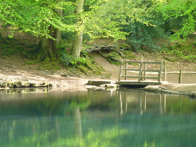
1022:== {{int:filedesc}} == {{Information |description={{en|1=Waggoners Wells Spring colours at the outflow of the middle pond. These were probably built as medieval fish ponds.}} |date=2009-05-10 |source=From [http://www.geograph.org.uk/photo/1297098 geograph
209:
401:– You must give appropriate credit, provide a link to the license, and indicate if changes were made. You may do so in any reasonable manner, but not in any way that suggests the licensor endorses you or your use.
273:
223:
691:
675:
631:
587:
683:
78:
496:
46:
900:
896:
832:
828:
687:
671:
583:
492:
484:
480:
699:
790:
695:
679:
627:
488:
476:
1015:
634:"}},"text\/plain":{"en":{"P275":"Creative Commons Attribution-ShareAlike 2.0 Generic"}}}}": -->
702:"}},"text\/plain":{"en":{"P973":"https:\/\/www.geograph.org.uk\/photo\/1297098"}}}}": -->
725:
657:
613:
283:
233:
745:
318:
1047:
This file contains additional information, probably added from the digital camera or scanner used to create or digitize it.
408:
568:
1036:
941:
914:
873:
846:
753:
709:
597:
561:
546:
533:
800:
768:
738:
641:
506:
465:
121:
Waggoners Wells Spring colours at the outflow of the middle pond. These were probably built as medieval fish ponds.
1004:
999:
37:
364:
1050:
If the file has been modified from its original state, some details may not fully reflect the modified file.
407:– If you remix, transform, or build upon the material, you must distribute your contributions under the
325:
on the
Geograph website for the photographer's contact details. The copyright on this image is owned by
499:"}},"text\/plain":{"en":{"P3831":"photographer"}}}}": -->
590:"}},"text\/plain":{"en":{"P6216":"copyrighted"}}}}": -->
1032:
The following pages on the
English Knowledge use this file (pages on other projects are not listed):
907:"}},"text\/plain":{"en":{"P7787":"157 degree"}}}}": -->
839:"}},"text\/plain":{"en":{"P7787":"157 degree"}}}}": -->
86:
775:
760:
553:
361:
162:
8:
305:
289:
239:
330:
73:
455:
178:
141:
151:
924:
856:
810:
719:
651:
607:
516:
310:
322:
972:
Click on a date/time to view the file as it appeared at that time.
275:
225:
260:
51° 06′ 05″ N, 0° 46′ 26″ W
210:
51° 06′ 07″ N, 0° 46′ 26″ W
130:
61:
449:
Add a one-line explanation of what this file represents
1030:
970:
85:
Commons is a freely licensed media file repository.
658:
Creative
Commons Attribution-ShareAlike 2.0 Generic
632:
Creative
Commons Attribution-ShareAlike 2.0 Generic
51:(640 × 480 pixels, file size: 114 KB, MIME type:
111:Waggoners Wells - geograph.org.uk - 1297098.jpg
47:Waggoners_Wells_-_geograph.org.uk_-_1297098.jpg
418:https://creativecommons.org/licenses/by-sa/2.0
66:
700:https:\/\/www.geograph.org.uk\/photo\/1297098
424:Creative Commons Attribution-Share Alike 2.0
342:
126:
108:
489:https:\/\/www.geograph.org.uk\/profile\/3972
147:
136:
14:
904:
836:
384:– to copy, distribute and transmit the work
776:https://www.geograph.org.uk/photo/1297098
554:https://www.geograph.org.uk/profile/3972
282:View this and other nearby images on:
232:View this and other nearby images on:
185:
97:
329:and is licensed for reuse under the
250:
200:
1037:Ludshott Common and Waggoners Wells
963:
365:Attribution-Share Alike 2.0 Generic
353:
348:
333:Attribution-ShareAlike 2.0 license.
13:
1045:
454:
448:
339:
316:
115:
98:
44:
1071:
1052:
453:
1031:
847:coordinates of the point of view
829:coordinates of the point of view
439:
395:Under the following conditions:
360:This file is licensed under the
352:
347:
341:
309:
288:
274:
266:
238:
224:
216:
65:
21:
436:
116:
41:No higher resolution available.
967:
726:file available on the internet
676:file available on the internet
435:
317:This image was taken from the
26:
1:
915:coordinates of depicted place
897:coordinates of depicted place
31:
1027:
746:Geograph Britain and Ireland
684:Geograph Britain and Ireland
562:object of statement has role
493:object of statement has role
461:Items portrayed in this file
301:
265:
215:
7:
1042:
10:
1076:
409:same or compatible license
105:
100:
964:
930:51°6'5.51"N, 0°46'26.04"W
862:51°6'7.13"N, 0°46'26.40"W
16:
754:geograph.org.uk image ID
688:geograph.org.uk image ID
438:
375:
191:Colin Smith /
172:Colin Smith /
72:This is a file from the
36:
1021:
1000:11:27, 27 February 2011
163:required by the license
129:
76:. Information from its
323:this photograph's page
294:51.101530; -0.773900
244:51.101980; -0.774000
79:description page there
390:– to adapt the work
534:author name string
481:author name string
1063:
1062:
1025:
906:
838:
642:copyright license
628:copyright license
447:
338:
337:
321:collection. See
299:
298:
249:
248:
198:
197:
166:
94:
93:
74:Wikimedia Commons
1067:
1053:
1012:
974:
952:
951:
946:
884:
883:
878:
778:
773:
769:described at URL
763:
758:
748:
743:
696:described at URL
598:copyright status
584:copyright status
571:
566:
556:
551:
541:
538:
445:
431:
428:
425:
422:
419:
411:as the original.
373:
362:Creative Commons
356:
355:
351:
350:
345:
344:
331:Creative Commons
319:Geograph project
313:
306:
295:
292:
278:
277:
271:
270:
269:
263:
262:
251:
245:
242:
228:
227:
221:
220:
219:
213:
212:
201:
160:
132:
120:
112:
106:
90:
69:
68:
62:
56:
54:
1075:
1074:
1070:
1069:
1068:
1066:
1065:
1064:
1041:
1033:
1026:
1018:
1010:
966:
965:
962:
961:
960:
959:
958:
957:
956:
955:
954:
953:
949:
947:
944:
935:
934:
933:
931:
921:
920:
919:
917:
894:
893:
892:
891:
890:
889:
888:
887:
886:
885:
881:
879:
876:
867:
866:
865:
863:
853:
852:
851:
849:
826:
825:
824:
823:
822:
821:
820:
819:
817:
807:
806:
805:
803:
788:
787:
786:
785:
784:
783:
782:
781:
780:
779:
774:
771:
765:
764:
759:
756:
750:
749:
744:
741:
732:
731:
730:
728:
716:
715:
714:
712:
669:
668:
667:
666:
665:
664:
663:
662:
660:
648:
647:
646:
644:
625:
624:
623:
622:
621:
620:
619:
618:
616:
604:
603:
602:
600:
581:
580:
579:
578:
577:
576:
575:
574:
573:
572:
567:
564:
558:
557:
552:
549:
543:
542:
539:
536:
527:
526:
525:
523:
513:
512:
511:
509:
474:
473:
472:
471:
470:
468:
452:
451:
450:
433:
432:
429:
426:
423:
420:
417:
416:
374:
371:
368:
357:
334:
304:
293:
267:
258:
257:
254:Object location
243:
217:
208:
207:
204:Camera location
199:
193:Waggoners Wells
188:
181:
174:Waggoners Wells
169:
142:geograph.org.uk
122:
110:
103:
96:
95:
84:
83:
82:is shown below.
58:
52:
50:
43:
42:
12:
11:
5:
1073:
1061:
1060:
1057:
1044:
1040:
1039:
1029:
1024:
1023:
1020:
1016:
1013:
1007:
1002:
997:
993:
992:
989:
986:
983:
980:
977:
969:
940:
939:
938:
937:
936:
932:
929:
927:
926:
925:
923:
922:
918:
913:
911:
910:
909:
908:
902:
898:
872:
871:
870:
869:
868:
864:
861:
859:
858:
857:
855:
854:
850:
845:
843:
842:
841:
840:
834:
830:
818:
815:
813:
812:
811:
809:
808:
804:
799:
797:
796:
795:
794:
792:
767:
766:
752:
751:
737:
736:
735:
734:
733:
729:
724:
722:
721:
720:
718:
717:
713:
710:source of file
708:
706:
705:
704:
703:
701:
697:
693:
689:
685:
681:
677:
673:
672:source of file
661:
656:
654:
653:
652:
650:
649:
645:
640:
638:
637:
636:
635:
633:
629:
617:
612:
610:
609:
608:
606:
605:
601:
596:
594:
593:
592:
591:
589:
585:
560:
559:
545:
544:
532:
531:
530:
529:
528:
524:
521:
519:
518:
517:
515:
514:
510:
505:
503:
502:
501:
500:
498:
494:
490:
486:
482:
478:
469:
464:
462:
459:
458:
457:
456:
444:
443:
440:
437:
415:
414:
413:
412:
402:
393:
392:
391:
385:
378:You are free:
369:
359:
358:
340:
336:
335:
314:
303:
300:
297:
296:
286:
280:
255:
247:
246:
236:
230:
205:
196:
195:
189:
186:
183:
182:
177:
170:
167:
155:
154:
149:
145:
144:
138:
134:
133:
128:
124:
123:
113:
104:
102:
99:
92:
91:
70:
60:
59:
40:
35:
34:
29:
24:
19:
9:
6:
4:
3:
2:
1072:
1058:
1055:
1054:
1051:
1048:
1038:
1035:
1034:
1019:
1014:
1008:
1006:
1003:
1001:
998:
995:
994:
990:
987:
984:
981:
978:
976:
975:
973:
943:
928:
916:
912:
875:
860:
848:
844:
814:
802:
798:
777:
770:
762:
755:
747:
740:
727:
723:
711:
707:
659:
655:
643:
639:
615:
611:
599:
595:
570:
563:
555:
548:
535:
520:
508:
504:
467:
463:
460:
441:
434:
421:CC BY-SA 2.0
410:
406:
403:
400:
397:
396:
394:
389:
386:
383:
380:
379:
377:
376:
370:Attribution:
366:
363:
346:
332:
328:
324:
320:
315:
312:
308:
307:
291:
287:
285:
284:OpenStreetMap
281:
279:
261:
256:
253:
252:
241:
237:
235:
234:OpenStreetMap
231:
229:
211:
206:
203:
202:
194:
190:
184:
180:
176: /
175:
171:
164:
159:
157:
156:
153:
150:
146:
143:
139:
135:
125:
119:
114:
107:
88:
81:
80:
75:
71:
64:
63:
57:
48:
39:
33:
30:
28:
25:
23:
20:
18:
15:
1049:
1046:
971:
968:File history
569:photographer
497:photographer
404:
398:
387:
381:
326:
264:
214:
192:
179:CC BY-SA 2.0
173:
117:
87:You can help
77:
45:
22:File history
1017:GeographBot
816:10 May 2009
614:copyrighted
588:copyrighted
540:Colin Smith
405:share alike
399:attribution
372:Colin Smith
327:Colin Smith
158:Attribution
152:Colin Smith
131:10 May 2009
109:Description
1056:_error
1028:File usage
1009:640 × 480
985:Dimensions
522:some value
53:image/jpeg
27:File usage
982:Thumbnail
979:Date/Time
801:inception
791:inception
302:Licensing
187:InfoField
168:InfoField
118:English:
1043:Metadata
1011:(114 KB)
739:operator
680:operator
442:Captions
388:to remix
382:to share
367:license.
32:Metadata
996:current
991:Comment
942:heading
901:heading
874:heading
833:heading
761:1297098
692:1297098
507:creator
477:creator
466:depicts
446:English
101:Summary
49:
950:degree
905:degree
882:degree
837:degree
272:
222:
148:Author
137:Source
140:From
988:User
948:157
880:157
430:true
427:true
127:Date
17:File
547:URL
485:URL
945::
877::
772::
757::
742::
565::
550::
537::
1059:0
165:)
161:(
89:.
55:)
_heading:157.00&language=en)
_heading:157.00&language=en)
