567:"}},"text\/plain":{"en":{"":"coordinates of the point of view"}}},"{\"value\":{\"latitude\":56.69978,\"longitude\":-2.4571,\"altitude\":null,\"precision\":1.0e-5,\"globe\":\"http:\\\/\\\/www.wikidata.org\\\/entity\\\/Q2\"},\"type\":\"globecoordinate\"}":{"text\/html":{"en":{"P1259":"56\u00b041'59.21"N, 2\u00b027'25.56"W"}},"text\/plain":{"en":{"P1259":"56\u00b041'59.21\"N, 2\u00b027'25.56\"W"}}},"{\"value\":{\"entity-type\":\"property\",\"numeric-id\":7787,\"id\":\"P7787\"},\"type\":\"wikibase-entityid\"}":{"text\/html":{"en":{"":"
673:"}},"text\/plain":{"en":{"":"coordinates of depicted place"}}},"{\"value\":{\"latitude\":56.7061,\"longitude\":-2.463,\"altitude\":null,\"precision\":0.0001,\"globe\":\"http:\\\/\\\/www.wikidata.org\\\/entity\\\/Q2\"},\"type\":\"globecoordinate\"}":{"text\/html":{"en":{"P9149":"56\u00b042'22.0"N, 2\u00b027'46.8"W"}},"text\/plain":{"en":{"P9149":"56\u00b042'22.0\"N, 2\u00b027'46.8\"W"}}},"{\"value\":{\"entity-type\":\"property\",\"numeric-id\":7787,\"id\":\"P7787\"},\"type\":\"wikibase-entityid\"}":{"text\/html":{"en":{"":"
635:"}},"text\/plain":{"en":{"":"inception"}}},"{\"value\":{\"time\":\"+2009-03-10T00:00:00Z\",\"timezone\":0,\"before\":0,\"after\":0,\"precision\":11,\"calendarmodel\":\"http:\\\/\\\/www.wikidata.org\\\/entity\\\/Q1985727\"},\"type\":\"time\"}":{"text\/html":{"en":{"P571":"10 March 2009"}},"text\/plain":{"en":{"P571":"10 March 2009"}}}}": -->
343:
276:
226:
268:
218:
669:
240:
311:
349:
354:
72:
523:"}},"text\/plain":{"en":{"":"copyright license"}}},"{\"value\":{\"entity-type\":\"item\",\"numeric-id\":19068220,\"id\":\"Q19068220\"},\"type\":\"wikibase-entityid\"}":{"text\/html":{"en":{"P275":"
479:"}},"text\/plain":{"en":{"":"copyright status"}}},"{\"value\":{\"entity-type\":\"item\",\"numeric-id\":50423863,\"id\":\"Q50423863\"},\"type\":\"wikibase-entityid\"}":{"text\/html":{"en":{"P6216":"
571:"}},"text\/plain":{"en":{"":"heading"}}},"{\"value\":{\"amount\":\"+337.0\",\"unit\":\"http:\\\/\\\/www.wikidata.org\\\/entity\\\/Q28390\"},\"type\":\"quantity\"}":{"text\/html":{"en":{"P7787":"337.0
677:"}},"text\/plain":{"en":{"":"heading"}}},"{\"value\":{\"amount\":\"+337\",\"unit\":\"http:\\\/\\\/www.wikidata.org\\\/entity\\\/Q28390\"},\"type\":\"quantity\"}":{"text\/html":{"en":{"P7787":"337
475:
259:
209:
401:– You must give appropriate credit, provide a link to the license, and indicate if changes were made. You may do so in any reasonable manner, but not in any way that suggests the licensor endorses you or your use.
43:
223:
273:
524:
480:
674:
670:
568:
564:
476:
632:
520:
853:
527:"}},"text\/plain":{"en":{"P275":"Creative Commons Attribution-ShareAlike 2.0 Generic"}}}}": -->
550:
506:
283:
233:
318:
1131:
This file contains additional information, probably added from the digital camera or scanner used to create or digitize it.
953:
408:
843:
1078:
833:
715:
688:
609:
582:
490:
642:
534:
465:
83:
1118:
51:
364:
1134:
If the file has been modified from its original state, some details may not fully reflect the modified file.
407:– If you remix, transform, or build upon the material, you must distribute your contributions under the
325:
on the
Geograph website for the photographer's contact details. The copyright on this image is owned by
575:"}},"text\/plain":{"en":{"P7787":"337.0 degree"}}}}": -->
483:"}},"text\/plain":{"en":{"P6216":"copyrighted"}}}}": -->
806:
The following pages on the
English Knowledge use this file (pages on other projects are not listed):
681:"}},"text\/plain":{"en":{"P7787":"337 degree"}}}}": -->
91:
178:
361:
162:
8:
863:
305:
1098:
289:
239:
330:
78:
778:
773:
455:
42:
815:
810:
968:
698:
652:
592:
544:
500:
310:
789:
322:
988:
963:
746:
Click on a date/time to view the file as it appeared at that time.
1028:
275:
225:
1058:
1068:
1048:
1038:
943:
933:
913:
893:
260:
56° 42′ 22″ N, 2° 27′ 47″ W
210:
56° 41′ 59″ N, 2° 27′ 26″ W
135:
66:
1018:
449:
Add a one-line explanation of what this file represents
1008:
1088:
978:
923:
873:
804:
1108:
824:
744:
90:
Commons is a freely licensed media file repository.
998:
903:
551:
Creative
Commons Attribution-ShareAlike 2.0 Generic
525:
Creative
Commons Attribution-ShareAlike 2.0 Generic
883:
56:(640 × 426 pixels, file size: 77 KB, MIME type:
418:https://creativecommons.org/licenses/by-sa/2.0
71:
424:Creative Commons Attribution-Share Alike 2.0
342:
131:
113:
149:
141:
14:
678:
572:
384:– to copy, distribute and transmit the work
864:Montrose (lungsod sa Hiniusang Gingharian)
826:The following other wikis use this file:
282:View this and other nearby images on:
232:View this and other nearby images on:
185:
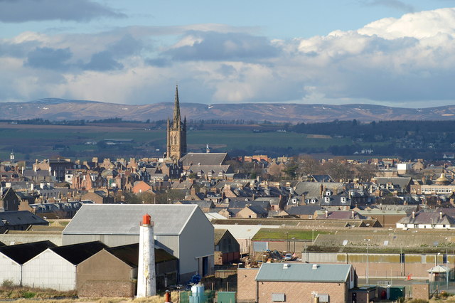
126:View of Montrose taken from Ferryden.
102:
329:and is licensed for reuse under the
250:
200:
737:
365:Attribution-Share Alike 2.0 Generic
353:
348:
333:Attribution-ShareAlike 2.0 license.
13:
1129:
454:
448:
339:
316:
120:
103:
49:
1155:
1136:
453:
805:
583:coordinates of the point of view
565:coordinates of the point of view
439:
395:Under the following conditions:
360:This file is licensed under the
352:
347:
341:
309:
288:
274:
266:
238:
224:
216:
70:
31:
21:
436:
121:
46:No higher resolution available.
821:
741:
435:
317:This image was taken from the
26:
1:
969:Utilisateur:Skiff/A illustrer
689:coordinates of depicted place
671:coordinates of depicted place
36:
801:
461:Items portrayed in this file
301:
265:
215:
7:
1126:
1085:Usage on sco.wikipedia.org
995:Usage on it.wikivoyage.org
910:Usage on en.wikivoyage.org
900:Usage on de.wikivoyage.org
860:Usage on ceb.wikipedia.org
840:Usage on arz.wikipedia.org
598:56°41'59.21"N, 2°27'25.56"W
10:
1160:
1115:Usage on zh.wikipedia.org
1105:Usage on www.wikidata.org
1095:Usage on uk.wikipedia.org
1075:Usage on ru.wikipedia.org
1065:Usage on pt.wikipedia.org
1055:Usage on pl.wikipedia.org
1045:Usage on no.wikipedia.org
1035:Usage on nn.wikipedia.org
1025:Usage on nl.wikipedia.org
1015:Usage on mt.wikipedia.org
1005:Usage on lt.wikipedia.org
985:Usage on it.wikipedia.org
975:Usage on ga.wikipedia.org
960:Usage on fr.wikipedia.org
950:Usage on fa.wikipedia.org
940:Usage on eu.wikipedia.org
930:Usage on es.wikipedia.org
920:Usage on eo.wikipedia.org
890:Usage on de.wikipedia.org
880:Usage on da.wikipedia.org
870:Usage on cy.wikipedia.org
850:Usage on bg.wikipedia.org
830:Usage on ar.wikipedia.org
409:same or compatible license
191:Alan Morrison /
172:Alan Morrison /
110:
105:
738:
704:56°42'22.0"N, 2°27'46.8"W
16:
438:
375:
77:This is a file from the
41:
795:
774:00:54, 9 September 2009
163:required by the license
134:
81:. Information from its
989:Montrose (Regno Unito)
323:this photograph's page
294:56.706100; -2.463000
244:56.699780; -2.457100
84:description page there
1029:Montrose (Schotland)
854:Монтроуз (Шотландия)
390:– to adapt the work
1059:Montrose (Szkocja)
116:Viewofmontrose.jpg
52:Viewofmontrose.jpg
1147:
1146:
964:Montrose (Écosse)
822:Global file usage
799:
680:
574:
535:copyright license
521:copyright license
447:
338:
337:
321:collection. See
299:
298:
249:
248:
198:
197:
166:
99:
98:
79:Wikimedia Commons
32:Global file usage
1151:
1137:
1069:Montrose (Angus)
1049:Montrose (Angus)
1039:Montrose i Angus
944:Montrose (Angus)
934:Montrose (Angus)
894:Montrose (Angus)
786:
748:
726:
725:
720:
620:
619:
614:
491:copyright status
477:copyright status
445:
431:
428:
425:
422:
419:
411:as the original.
373:
362:Creative Commons
356:
355:
351:
350:
345:
344:
331:Creative Commons
319:Geograph project
313:
306:
295:
292:
278:
277:
271:
270:
269:
263:
262:
251:
245:
242:
228:
227:
221:
220:
219:
213:
212:
201:
193:View of Montrose
174:View of Montrose
160:
137:
125:
117:
111:
95:
74:
73:
67:
61:
59:
1159:
1158:
1154:
1153:
1152:
1150:
1149:
1148:
1125:
1079:Монтроз (город)
914:North Sea Trail
844:مونتروز (انجوس)
834:مونتروز (أنغوس)
820:
816:Montrose, Angus
811:Angus, Scotland
807:
800:
792:
784:
740:
739:
736:
735:
734:
733:
732:
731:
730:
729:
728:
727:
723:
721:
718:
709:
708:
707:
705:
695:
694:
693:
691:
668:
667:
666:
665:
664:
663:
662:
661:
659:
649:
648:
647:
645:
630:
629:
628:
627:
626:
625:
624:
623:
622:
621:
617:
615:
612:
603:
602:
601:
599:
589:
588:
587:
585:
562:
561:
560:
559:
558:
557:
556:
555:
553:
541:
540:
539:
537:
518:
517:
516:
515:
514:
513:
512:
511:
509:
497:
496:
495:
493:
474:
473:
472:
471:
470:
468:
452:
451:
450:
433:
432:
429:
426:
423:
420:
417:
416:
374:
371:
368:
357:
334:
304:
293:
267:
258:
257:
254:Object location
243:
217:
208:
207:
204:Camera location
199:
188:
181:
169:
127:
115:
108:
101:
100:
89:
88:
87:is shown below.
63:
57:
55:
48:
47:
12:
11:
5:
1157:
1145:
1144:
1141:
1128:
1124:
1123:
1122:
1121:
1113:
1112:
1111:
1103:
1102:
1101:
1093:
1092:
1091:
1083:
1082:
1081:
1073:
1072:
1071:
1063:
1062:
1061:
1053:
1052:
1051:
1043:
1042:
1041:
1033:
1032:
1031:
1023:
1022:
1021:
1013:
1012:
1011:
1003:
1002:
1001:
993:
992:
991:
983:
982:
981:
973:
972:
971:
966:
958:
957:
956:
954:مونتروز، انگوس
948:
947:
946:
938:
937:
936:
928:
927:
926:
918:
917:
916:
908:
907:
906:
898:
897:
896:
888:
887:
886:
878:
877:
876:
868:
867:
866:
858:
857:
856:
848:
847:
846:
838:
837:
836:
823:
819:
818:
813:
803:
798:
797:
794:
790:
787:
781:
776:
771:
767:
766:
763:
760:
757:
754:
751:
743:
714:
713:
712:
711:
710:
706:
703:
701:
700:
699:
697:
696:
692:
687:
685:
684:
683:
682:
676:
672:
660:
657:
655:
654:
653:
651:
650:
646:
641:
639:
638:
637:
636:
634:
608:
607:
606:
605:
604:
600:
597:
595:
594:
593:
591:
590:
586:
581:
579:
578:
577:
576:
570:
566:
554:
549:
547:
546:
545:
543:
542:
538:
533:
531:
530:
529:
528:
526:
522:
510:
505:
503:
502:
501:
499:
498:
494:
489:
487:
486:
485:
484:
482:
478:
469:
464:
462:
459:
458:
457:
456:
444:
443:
440:
437:
415:
414:
413:
412:
402:
393:
392:
391:
385:
378:You are free:
369:
359:
358:
340:
336:
335:
314:
303:
300:
297:
296:
286:
280:
255:
247:
246:
236:
230:
205:
196:
195:
189:
186:
183:
182:
177:
170:
167:
155:
154:
151:
147:
146:
143:
139:
138:
133:
129:
128:
118:
109:
107:
104:
97:
96:
75:
65:
64:
45:
40:
39:
34:
29:
24:
19:
9:
6:
4:
3:
2:
1156:
1142:
1139:
1138:
1135:
1132:
1120:
1117:
1116:
1114:
1110:
1107:
1106:
1104:
1100:
1097:
1096:
1094:
1090:
1087:
1086:
1084:
1080:
1077:
1076:
1074:
1070:
1067:
1066:
1064:
1060:
1057:
1056:
1054:
1050:
1047:
1046:
1044:
1040:
1037:
1036:
1034:
1030:
1027:
1026:
1024:
1020:
1017:
1016:
1014:
1010:
1007:
1006:
1004:
1000:
997:
996:
994:
990:
987:
986:
984:
980:
977:
976:
974:
970:
967:
965:
962:
961:
959:
955:
952:
951:
949:
945:
942:
941:
939:
935:
932:
931:
929:
925:
922:
921:
919:
915:
912:
911:
909:
905:
902:
901:
899:
895:
892:
891:
889:
885:
882:
881:
879:
875:
872:
871:
869:
865:
862:
861:
859:
855:
852:
851:
849:
845:
842:
841:
839:
835:
832:
831:
829:
828:
827:
817:
814:
812:
809:
808:
793:
788:
782:
780:
777:
775:
772:
769:
768:
764:
761:
758:
755:
752:
750:
749:
747:
717:
702:
690:
686:
658:10 March 2009
656:
644:
640:
611:
596:
584:
580:
552:
548:
536:
532:
508:
504:
492:
488:
467:
463:
460:
441:
434:
421:CC BY-SA 2.0
410:
406:
403:
400:
397:
396:
394:
389:
386:
383:
380:
379:
377:
376:
372:Alan Morrison
370:Attribution:
366:
363:
346:
332:
328:
327:Alan Morrison
324:
320:
315:
312:
308:
307:
291:
287:
285:
284:OpenStreetMap
281:
279:
261:
256:
253:
252:
241:
237:
235:
234:OpenStreetMap
231:
229:
211:
206:
203:
202:
194:
190:
184:
180:
176: /
175:
171:
164:
159:
157:
156:
153:Alan Morrison
152:
148:
144:
140:
136:10 March 2009
130:
124:
119:
112:
93:
86:
85:
80:
76:
69:
68:
62:
53:
44:
38:
35:
33:
30:
28:
25:
23:
20:
18:
15:
1133:
1130:
825:
745:
742:File history
404:
398:
387:
381:
326:
264:
214:
192:
179:CC BY-SA 2.0
173:
122:
92:You can help
82:
50:
22:File history
507:copyrighted
481:copyrighted
405:share alike
399:attribution
158:Attribution
114:Description
1140:_error
1119:蒙特羅斯 (蘇格蘭)
1019:Renju Unit
802:File usage
783:640 × 426
759:Dimensions
58:image/jpeg
27:File usage
1009:Montrozas
756:Thumbnail
753:Date/Time
643:inception
633:inception
302:Licensing
187:InfoField
168:InfoField
145:see below
123:English:
1127:Metadata
979:Mon Rois
924:Montrose
874:Montrose
442:Captions
388:to remix
382:to share
367:license.
37:Metadata
1109:Q420303
1099:Монтроз
1089:Munross
785:(77 KB)
770:current
765:Comment
716:heading
675:heading
610:heading
569:heading
466:depicts
446:English
106:Summary
54:
724:degree
679:degree
618:degree
616:337.0
573:degree
272:
222:
150:Author
142:Source
999:Angus
904:Angus
884:Angus
791:Lcw27
762:User
722:337
430:true
427:true
132:Date
17:File
719::
613::
1143:0
165:)
161:(
94:.
60:)
_heading:337.00&language=en)
_heading:337.00&language=en)
