660:"}},"text\/plain":{"en":{"":"inception"}}},"{\"value\":{\"time\":\"+2010-04-24T00:00:00Z\",\"timezone\":0,\"before\":0,\"after\":0,\"precision\":11,\"calendarmodel\":\"http:\\\/\\\/www.wikidata.org\\\/entity\\\/Q1985727\"},\"type\":\"time\"}":{"text\/html":{"en":{"P571":"24 April 2010"}},"text\/plain":{"en":{"P571":"24 April 2010"}}}}": -->
43:
440:
215:
335:
250:
452:","P2093":"Uwe Dedering"}},"text\/plain":{"en":{"P4174":"Uwe Dedering","P2093":"Uwe Dedering"}}},"{\"value\":{\"entity-type\":\"property\",\"numeric-id\":2093,\"id\":\"P2093\"},\"type\":\"wikibase-entityid\"}":{"text\/html":{"en":{"":"
255:
95:
599:"}},"text\/plain":{"en":{"P275":"GNU Free Documentation License, version 1.2 or later"}}},"{\"value\":{\"entity-type\":\"item\",\"numeric-id\":14946043,\"id\":\"Q14946043\"},\"type\":\"wikibase-entityid\"}":{"text\/html":{"en":{"P275":"
595:"}},"text\/plain":{"en":{"":"copyright license"}}},"{\"value\":{\"entity-type\":\"item\",\"numeric-id\":50829104,\"id\":\"Q50829104\"},\"type\":\"wikibase-entityid\"}":{"text\/html":{"en":{"P275":"
551:"}},"text\/plain":{"en":{"":"copyright status"}}},"{\"value\":{\"entity-type\":\"item\",\"numeric-id\":50423863,\"id\":\"Q50423863\"},\"type\":\"wikibase-entityid\"}":{"text\/html":{"en":{"P6216":"
698:"}},"text\/plain":{"en":{"":"source of file"}}},"{\"value\":{\"entity-type\":\"item\",\"numeric-id\":66458942,\"id\":\"Q66458942\"},\"type\":\"wikibase-entityid\"}":{"text\/html":{"en":{"P7482":"
456:"}},"text\/plain":{"en":{"":"author name string"}}},"{\"value\":{\"entity-type\":\"property\",\"numeric-id\":2699,\"id\":\"P2699\"},\"type\":\"wikibase-entityid\"}":{"text\/html":{"en":{"":"
444:"}},"text\/plain":{"en":{"":"creator"}}},"{\"value\":{\"entity-type\":\"property\",\"numeric-id\":4174,\"id\":\"P4174\"},\"type\":\"wikibase-entityid\"}":{"text\/html":{"en":{"":"
694:
460:"}},"text\/plain":{"en":{"":"URL"}}},"{\"value\":\"https:\\\/\\\/commons.wikimedia.org\\\/wiki\\\/user:Uwe_Dedering\",\"type\":\"string\"}":{"text\/html":{"en":{"P2699":"
448:"}},"text\/plain":{"en":{"":"Wikimedia username"}}},"{\"value\":\"Uwe Dedering\",\"type\":\"string\"}":{"text\/html":{"en":{"P4174":"
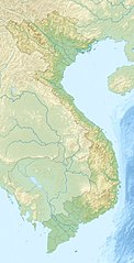
797:{{Information |Description={{en|1=Location map of Vietnam. Equirectangular projection. Strechted by 104.0%. Geographic limits of the map: * N: 24.0° N * S: 8.0° N * W: 101.8° E * E: 110.3° E Made with Natural Earth. Free vector and raster map da
413:
Bản đồ vị trí của Việt Nam. Phép chiếu hình tam giác. Rải rác 104,0%. Giới hạn địa lý của bản đồ: * N: 24,0 ° N * S: 8,0 ° N * W: 101,8 ° E * E: 110,3 ° E Được tạo ra từ Trái đất tự nhiên. Dữ liệu bản đồ vector và raster miễn phí
296:– You must give appropriate credit, provide a link to the license, and indicate if changes were made. You may do so in any reasonable manner, but not in any way that suggests the licensor endorses you or your use.
449:
1295:
461:
699:
600:
596:
552:
1495:
995:
1355:
1445:
1317:
808:
695:
548:
457:
453:
445:
657:
592:
441:
1520:
352:
1639:
464:"}},"text\/plain":{"en":{"P2699":"https:\/\/commons.wikimedia.org\/wiki\/user:Uwe_Dedering"}}}}": -->
1345:
603:"}},"text\/plain":{"en":{"P275":"Creative Commons Attribution-ShareAlike 3.0 Unported"}}}}": -->
61:
57:
53:
47:
1300:
106:
1505:
1130:
1590:
205:
74:
350:; with no Invariant Sections, no Front-Cover Texts, and no Back-Cover Texts. A copy of the license is included in the section entitled
890:
725:
643:
626:
578:
1290:
1260:
1650:
This file contains additional information, probably added from the digital camera or scanner used to create or digitize it.
303:
1200:
1535:
1490:
709:
562:
526:
513:
498:
702:"}},"text\/plain":{"en":{"P7482":"original creation by uploader"}}}}": -->
342:
1595:
667:
610:
471:
430:
1150:
505:
1030:
880:
1065:
910:
265:
930:
1653:
If the file has been modified from its original state, some details may not fully reflect the modified file.
1270:
905:
807:
More than 100 pages use this file. The following list shows the first 100 pages that use this file only. A
347:
1155:
214:
1580:
900:
302:– If you remix, transform, or build upon the material, you must distribute your contributions under the
1265:
1365:
970:
840:
555:"}},"text\/plain":{"en":{"P6216":"copyrighted"}}}}": -->
1170:
1015:
870:
1035:
925:
860:
850:
1285:
1255:
1105:
940:
533:
1195:
1120:
779:
774:
114:
65:
42:
1080:
1020:
915:
835:
1275:
1190:
1025:
855:
1470:
1000:
830:
200:
1230:
1175:
1110:
1050:
945:
885:
815:
340:
Permission is granted to copy, distribute and/or modify this document under the terms of the
1280:
1220:
1205:
1145:
990:
1415:
1310:
1215:
1185:
1135:
262:
1465:
1460:
1180:
1060:
865:
8:
1225:
1085:
960:
1585:
1010:
825:
1625:
1615:
1610:
1605:
1570:
1500:
1375:
1040:
185:
1070:
1240:
1045:
790:
237:
I, the copyright holder of this work, hereby publish it under the following licenses:
101:
1420:
420:
980:
1630:
1620:
1600:
1530:
1525:
1515:
1485:
1235:
1005:
875:
1055:
156:
Made with
Natural Earth. Free vector and raster map data @ naturalearthdata.com.
1305:
1250:
1245:
1210:
845:
820:
151:
Equirectangular projection. Strechted by 104.0%. Geographic limits of the map:
1075:
920:
1100:
950:
1540:
1510:
1380:
1335:
1165:
1125:
1575:
1555:
1550:
1430:
1160:
985:
895:
935:
719:
677:
637:
620:
572:
481:
1140:
1090:
955:
1410:
1095:
975:
1400:
1296:
User:Ty654/List of earthquakes from 1930-1939 exceeding magnitude 6+
329:
965:
747:
Click on a date/time to view the file as it appeared at that time.
1385:
1390:
1565:
1115:
1545:
1475:
165:
89:
1435:
1395:
462:
https:\/\/commons.wikimedia.org\/wiki\/user:Uwe_Dedering
79:(1,200 × 2,349 pixels, file size: 1.68 MB, MIME type:
805:
154:* N: 24.0° N * S: 8.0° N * W: 101.8° E * E: 110.3° E
1326:
745:
644:
Creative
Commons Attribution-ShareAlike 3.0 Unported
627:
601:
Creative
Commons Attribution-ShareAlike 3.0 Unported
597:
346:, Version 1.2 or any later version published by the
113:
Commons is a freely licensed media file repository.
1455:
1471:Module:Mapa nin kinamumugtakan/datos/Bietnam/doc
534:https://commons.wikimedia.org/user:Uwe_Dedering
1366:Módulu:Mapa de llocalización/datos/Vietnam/usu
996:Hàm Thuận – Đa Mi hydroelectric power stations
313:https://creativecommons.org/licenses/by-sa/3.0
94:
319:Creative Commons Attribution-Share Alike 3.0
243:
161:
136:
1466:Module:Mapa nin kinamumugtakan/datos/Bietnam
1461:Module:Mapa nin kinamumugtakan/datos/Vietnam
1301:Knowledge talk:WikiProject Vietnam/Archive 5
191:
181:
171:
14:
279:– to copy, distribute and transmit the work
378:You may select the license of your choice.
1328:The following other wikis use this file:
1291:User:LyamDuong/Sapa Ancient Rock Field
206:LocationVietnamBacNinhRelief200px.png
125:
358:http://www.gnu.org/copyleft/fdl.html
266:Attribution-Share Alike 3.0 Unported
1261:Đa Nhim Hydroelectric Power Station
738:
254:
249:
13:
1648:
419:
412:
404:
396:
377:
240:
236:
143:
126:
72:
1674:
1655:
1201:Tràng An Scenic Landscape Complex
1151:Red River Delta Biosphere Reserve
1131:Phong Nha – Kẻ Bàng National Park
418:
1416:Taman Nasional Phong Nha-Kẻ Bàng
387:
334:
333:
290:Under the following conditions:
261:This file is licensed under the
253:
248:
242:
213:
93:
31:
21:
384:
196:Derivative works of this file:
144:
139:Vietnam relief location map.jpg
1336:Vorlage:Positionskarte Vietnam
1323:
1031:Imperial Citadel of Thăng Long
742:
383:
364:GNU Free Documentation License
353:GNU Free Documentation License
343:GNU Free Documentation License
26:
1:
1431:Vorlog:Positionskarte Vietnam
1156:Saigon Governor's Palace
726:original creation by uploader
700:original creation by uploader
36:
1421:Taman Nasional Bidoup Núi Bà
802:
426:Items portrayed in this file
230:
7:
1645:
1452:Usage on bcl.wikipedia.org
1427:Usage on bar.wikipedia.org
1407:Usage on ban.wikipedia.org
1376:Şablon:Yer xəritəsi Vyetnam
1362:Usage on ast.wikipedia.org
1332:Usage on als.wikipedia.org
881:Bidoup Núi Bà National Park
10:
1679:
1562:Usage on bg.wikipedia.org
1482:Usage on be.wikipedia.org
1442:Usage on ba.wikipedia.org
1372:Usage on az.wikipedia.org
1352:Usage on ar.wikipedia.org
1342:Usage on am.wikipedia.org
304:same or compatible license
133:
128:
971:Hana Bank Vietnam Masters
931:Citadel of the Hồ Dynasty
739:
220:Equivalent political map
175:
149:Location map of Vietnam.
16:
1346:መለጠፊያ:Location map ቬት ናም
911:Bù Gia Mập National Park
891:Bà Rịa–Vũng Tàu province
861:Battle of Mang Yang Pass
851:Battle of Hamburger Hill
386:
348:Free Software Foundation
270:
100:This is a file from the
41:
1496:Шаблон:На карце/В’етнам
1356:قالب:خريطة مواقع فيتنام
1121:Perrottetia hongthinhae
1066:Murder of Lê Hoàng Hùng
796:
397:Location map of Vietnam
164:
104:. Information from its
1446:Ҡалып:ПозКарта Вьетнам
1026:Ichthyophis nguyenorum
856:Battle of Hanoi (1946)
107:description page there
46:Size of this preview:
1521:К’ензянг (запаведнік)
1111:Operation Ivory Coast
886:Black Virgin Mountain
841:Ban Gioc–Detian Falls
1411:Taman Nasional Ba Vì
1311:Portal:Vietnam/Intro
1136:Phu Luong (mountain)
1036:Imperial City of Huế
926:Bến En National Park
836:Ba Vì mountain range
775:10:30, 24 April 2010
66:1,200 × 2,349 pixels
1271:Định Bình Reservoir
1196:Tiền Giang province
1071:Mutter's Ridge
1001:Hàn River (Vietnam)
961:Elephant Waterfalls
906:Bình Phước province
901:Bình Dương province
831:Ba Vì National Park
285:– to adapt the work
52:Other resolutions:
1506:Камау (паўвостраў)
1171:Sơn Thắng massacre
1146:Phú Ninh Reservoir
1041:Indrapura (Champa)
1016:Hồng Lĩnh mountain
871:Battle of Xuân Lộc
514:author name string
499:Wikimedia username
454:author name string
446:Wikimedia username
1666:
1665:
1640:more global usage
1591:Шаблон:ПК Виетнам
1324:Global file usage
1286:Đồng Nai province
1266:Đại Hùng oilfield
1256:Yên Lập Reservoir
1241:West Lake (Hanoi)
1191:Thác Bà Reservoir
1106:Núi Cốc Reservoir
941:Cấm Sơn Reservoir
866:Battle of Núi Bop
816:Ayun Hạ Reservoir
800:
611:copyright license
593:copyright license
411:
403:
395:
375:
374:
227:
226:
122:
121:
102:Wikimedia Commons
32:Global file usage
1670:
1656:
1536:Тхо-Чу (астравы)
1386:Katba arxipelaqı
1381:Şondonq mağarası
1231:Tây Sơn district
1216:Trị An Reservoir
1186:Thiền Quang Lake
1176:Sơn Trà Mountain
1051:Krông Năng River
1021:Hội Khánh Temple
981:Ho Chi Minh City
826:Ba Chúc massacre
787:
749:
563:copyright status
549:copyright status
536:
531:
521:
518:
508:
503:
409:
401:
393:
371:
368:
365:
362:
359:
337:
336:
330:
326:
323:
320:
317:
314:
306:as the original.
263:Creative Commons
257:
256:
252:
251:
246:
245:
217:
177:
167:
148:
140:
134:
118:
97:
96:
90:
84:
82:
69:
62:392 × 768 pixels
58:245 × 480 pixels
54:122 × 240 pixels
48:306 × 599 pixels
1678:
1677:
1673:
1672:
1671:
1669:
1668:
1667:
1644:
1491:Фонг-Ня-Ке-Банг
1322:
1236:Vijaya (Champa)
1081:Mã Pí Lèng Pass
916:Búng Bình Thiên
876:Battle of Yu Oc
801:
793:
785:
741:
740:
737:
736:
735:
734:
733:
732:
731:
730:
728:
716:
715:
714:
712:
693:
692:
691:
690:
689:
688:
687:
686:
684:
674:
673:
672:
670:
655:
654:
653:
652:
651:
650:
649:
648:
646:
635:
634:
633:
632:
631:
629:
617:
616:
615:
613:
590:
589:
588:
587:
586:
585:
584:
583:
581:
569:
568:
567:
565:
546:
545:
544:
543:
542:
541:
540:
539:
538:
537:
532:
529:
523:
522:
519:
516:
510:
509:
504:
501:
492:
491:
490:
488:
478:
477:
476:
474:
439:
438:
437:
436:
435:
433:
417:
416:
415:
407:
406:
399:
398:
381:
380:
379:
369:
366:
363:
360:
357:
328:
327:
324:
321:
318:
315:
312:
311:
269:
258:
239:
238:
233:
228:
221:
218:
157:
155:
138:
131:
124:
123:
112:
111:
110:is shown below.
86:
80:
78:
71:
70:
51:
12:
11:
5:
1676:
1664:
1663:
1660:
1647:
1642:of this file.
1636:
1635:
1634:
1633:
1628:
1623:
1618:
1613:
1608:
1603:
1598:
1593:
1588:
1583:
1578:
1573:
1568:
1560:
1559:
1558:
1553:
1548:
1543:
1538:
1533:
1528:
1523:
1518:
1513:
1508:
1503:
1498:
1493:
1488:
1480:
1479:
1478:
1473:
1468:
1463:
1458:
1450:
1449:
1448:
1440:
1439:
1438:
1433:
1425:
1424:
1423:
1418:
1413:
1405:
1404:
1403:
1398:
1393:
1391:Halonq buxtası
1388:
1383:
1378:
1370:
1369:
1368:
1360:
1359:
1358:
1350:
1349:
1348:
1340:
1339:
1338:
1325:
1320:to this file.
1314:
1313:
1308:
1306:Portal:Vietnam
1303:
1298:
1293:
1288:
1283:
1281:Đồng Nai River
1278:
1273:
1268:
1263:
1258:
1253:
1251:Yankee Station
1248:
1246:Yali Falls Dam
1243:
1238:
1233:
1228:
1226:Tà Cú Mountain
1223:
1221:Tuyền Lâm Lake
1218:
1213:
1208:
1206:Trúc Bạch Lake
1203:
1198:
1193:
1188:
1183:
1178:
1173:
1168:
1163:
1158:
1153:
1148:
1143:
1138:
1133:
1128:
1123:
1118:
1113:
1108:
1103:
1098:
1093:
1088:
1083:
1078:
1073:
1068:
1063:
1058:
1053:
1048:
1043:
1038:
1033:
1028:
1023:
1018:
1013:
1008:
1003:
998:
993:
991:Hoàn Kiếm Lake
988:
983:
978:
973:
968:
963:
958:
953:
948:
943:
938:
933:
928:
923:
918:
913:
908:
903:
898:
893:
888:
883:
878:
873:
868:
863:
858:
853:
848:
846:Ban Karai Pass
843:
838:
833:
828:
823:
818:
811:is available.
804:
799:
798:
795:
791:
788:
784:1,200 × 2,349
782:
777:
772:
768:
767:
764:
761:
758:
755:
752:
744:
729:
724:
722:
721:
720:
718:
717:
713:
710:source of file
708:
706:
705:
704:
703:
701:
697:
696:source of file
685:
682:
680:
679:
678:
676:
675:
671:
666:
664:
663:
662:
661:
659:
647:
642:
640:
639:
638:
636:
630:
625:
623:
622:
621:
619:
618:
614:
609:
607:
606:
605:
604:
602:
598:
594:
582:
577:
575:
574:
573:
571:
570:
566:
561:
559:
558:
557:
556:
554:
550:
525:
524:
512:
511:
497:
496:
495:
494:
493:
489:
486:
484:
483:
482:
480:
479:
475:
470:
468:
467:
466:
465:
463:
459:
455:
451:
447:
443:
434:
429:
427:
424:
423:
422:
421:
408:
400:
392:
391:
388:
385:
376:
373:
372:
338:
310:
309:
308:
307:
297:
288:
287:
286:
280:
273:You are free:
260:
259:
241:
235:
234:
232:
229:
225:
224:
223:
222:
219:
212:
209:
208:
203:
193:
192:Other versions
189:
188:
183:
179:
178:
173:
169:
168:
163:
159:
158:
153:
141:
132:
130:
127:
120:
119:
98:
88:
87:
45:
40:
39:
34:
29:
24:
19:
9:
6:
4:
3:
2:
1675:
1661:
1658:
1657:
1654:
1651:
1643:
1641:
1632:
1629:
1627:
1624:
1622:
1619:
1617:
1614:
1612:
1609:
1607:
1604:
1602:
1599:
1597:
1596:Фонгня-Кебанг
1594:
1592:
1589:
1587:
1584:
1582:
1579:
1577:
1574:
1572:
1569:
1567:
1564:
1563:
1561:
1557:
1554:
1552:
1549:
1547:
1544:
1542:
1539:
1537:
1534:
1532:
1529:
1527:
1524:
1522:
1519:
1517:
1514:
1512:
1509:
1507:
1504:
1502:
1499:
1497:
1494:
1492:
1489:
1487:
1484:
1483:
1481:
1477:
1474:
1472:
1469:
1467:
1464:
1462:
1459:
1457:
1454:
1453:
1451:
1447:
1444:
1443:
1441:
1437:
1434:
1432:
1429:
1428:
1426:
1422:
1419:
1417:
1414:
1412:
1409:
1408:
1406:
1402:
1399:
1397:
1394:
1392:
1389:
1387:
1384:
1382:
1379:
1377:
1374:
1373:
1371:
1367:
1364:
1363:
1361:
1357:
1354:
1353:
1351:
1347:
1344:
1343:
1341:
1337:
1334:
1333:
1331:
1330:
1329:
1321:
1319:
1312:
1309:
1307:
1304:
1302:
1299:
1297:
1294:
1292:
1289:
1287:
1284:
1282:
1279:
1277:
1276:Đống Đa Mound
1274:
1272:
1269:
1267:
1264:
1262:
1259:
1257:
1254:
1252:
1249:
1247:
1244:
1242:
1239:
1237:
1234:
1232:
1229:
1227:
1224:
1222:
1219:
1217:
1214:
1212:
1209:
1207:
1204:
1202:
1199:
1197:
1194:
1192:
1189:
1187:
1184:
1182:
1181:Tam Điệp pass
1179:
1177:
1174:
1172:
1169:
1167:
1164:
1162:
1159:
1157:
1154:
1152:
1149:
1147:
1144:
1142:
1139:
1137:
1134:
1132:
1129:
1127:
1124:
1122:
1119:
1117:
1114:
1112:
1109:
1107:
1104:
1102:
1099:
1097:
1094:
1092:
1089:
1087:
1084:
1082:
1079:
1077:
1074:
1072:
1069:
1067:
1064:
1062:
1061:Mount Mẫu Sơn
1059:
1057:
1054:
1052:
1049:
1047:
1046:Khau Phạ Pass
1044:
1042:
1039:
1037:
1034:
1032:
1029:
1027:
1024:
1022:
1019:
1017:
1014:
1012:
1009:
1007:
1004:
1002:
999:
997:
994:
992:
989:
987:
984:
982:
979:
977:
974:
972:
969:
967:
964:
962:
959:
957:
954:
952:
951:Dixie Station
949:
947:
946:Cửa Lớn River
944:
942:
939:
937:
934:
932:
929:
927:
924:
922:
919:
917:
914:
912:
909:
907:
904:
902:
899:
897:
894:
892:
889:
887:
884:
882:
879:
877:
874:
872:
869:
867:
864:
862:
859:
857:
854:
852:
849:
847:
844:
842:
839:
837:
834:
832:
829:
827:
824:
822:
819:
817:
814:
813:
812:
810:
794:
789:
783:
781:
778:
776:
773:
770:
769:
765:
762:
759:
756:
753:
751:
750:
748:
727:
723:
711:
707:
683:24 April 2010
681:
669:
665:
645:
641:
628:
624:
612:
608:
580:
576:
564:
560:
535:
528:
515:
507:
500:
485:
473:
469:
432:
428:
425:
405:Mapa Wietnamu
389:
382:
355:
354:
349:
345:
344:
339:
332:
331:
316:CC BY-SA 3.0
305:
301:
298:
295:
292:
291:
289:
284:
281:
278:
275:
274:
272:
271:
267:
264:
247:
216:
211:
210:
207:
204:
202:
201:Pays Taï .jpg
199:
198:
197:
194:
190:
187:
184:
180:
174:
170:
166:24 April 2010
160:
152:
147:
142:
135:
116:
109:
108:
103:
99:
92:
91:
85:
76:
75:Original file
67:
63:
59:
55:
49:
44:
38:
35:
33:
30:
28:
25:
23:
20:
18:
15:
1652:
1649:
1637:
1327:
1315:
1161:Saigon River
1056:Lai Châu Dam
1011:Hải Vân Pass
986:Ho Tram Open
806:
792:Uwe Dedering
746:
743:File history
520:Uwe Dedering
506:Uwe Dedering
450:Uwe Dedering
414:@naturaleart
351:
341:
299:
293:
282:
276:
195:
186:Uwe Dedering
150:
145:
115:You can help
105:
73:
22:File history
1476:Ha Long Bay
1396:Kamau burnu
1141:Phu Si Lung
1091:Na Hang Dam
1086:Mụ Giạ Pass
1006:Hạ Long Bay
956:Dong Ap Bia
579:copyrighted
553:copyrighted
300:share alike
294:attribution
137:Description
1659:_error
1581:Диенбиенфу
1436:Truong Son
1318:more links
1211:Trị An Dam
1166:Sơn La Dam
1126:Phong Châu
1096:Ngang Pass
976:Hinh River
821:Ba Bể Lake
803:File usage
760:Dimensions
487:some value
410:Vietnamese
81:image/jpeg
27:File usage
1101:Ngọc Linh
936:Côn River
809:full list
786:(1.68 MB)
757:Thumbnail
754:Date/Time
668:inception
658:inception
231:Licensing
146:English:
1646:Metadata
1586:Тхай Бин
1401:Çıonqşon
966:Fansipan
390:Captions
283:to remix
277:to share
268:license.
176:Own work
37:Metadata
1631:Ня Чанг
1626:Вунгтау
1621:Кан Тхо
1616:Хайфонг
1611:Донгхой
1606:Шондонг
1571:Хошимин
1501:Шандонг
1076:Mán Bạc
921:Bảy Núi
896:Bàu Tró
771:current
766:Comment
472:creator
442:creator
431:depicts
394:English
129:Summary
77:
1601:Дананг
1541:Тхо-Чу
1531:Кансон
1526:Кандаа
1516:Фукуок
1511:Кат-Ба
1486:Меконг
402:Polish
182:Author
172:Source
1638:View
1576:Ханой
1556:Лісын
1551:Бакбо
1456:Hanoi
1316:View
1116:PIRAZ
763:User
370:true
367:true
361:GFDL
325:true
322:true
162:Date
17:File
1566:Хюе
527:URL
458:URL
1546:Да
530::
517::
502::
64:|
60:|
56:|
50:.
1662:0
356:.
117:.
83:)
68:.

