43:
525:"}},"text\/plain":{"en":{"":"inception"}}},"{\"value\":{\"time\":\"+2002-01-13T00:00:00Z\",\"timezone\":0,\"before\":0,\"after\":0,\"precision\":11,\"calendarmodel\":\"http:\\\/\\\/www.wikidata.org\\\/entity\\\/Q1985727\"},\"type\":\"time\"}":{"text\/html":{"en":{"P571":"13 January 2002"}},"text\/plain":{"en":{"P571":"13 January 2002"}}}}": -->
425:
227:
103:
265:
445:"}},"text\/plain":{"en":{"":"determination method"}}},"{\"value\":{\"entity-type\":\"item\",\"numeric-id\":60671452,\"id\":\"Q60671452\"},\"type\":\"wikibase-entityid\"}":{"text\/html":{"en":{"P459":"
441:"}},"text\/plain":{"en":{"P1001":"United States of America"}}},"{\"value\":{\"entity-type\":\"property\",\"numeric-id\":459,\"id\":\"P459\"},\"type\":\"wikibase-entityid\"}":{"text\/html":{"en":{"":"
437:"}},"text\/plain":{"en":{"":"applies to jurisdiction"}}},"{\"value\":{\"entity-type\":\"item\",\"numeric-id\":30,\"id\":\"Q30\"},\"type\":\"wikibase-entityid\"}":{"text\/html":{"en":{"P1001":"
429:"}},"text\/plain":{"en":{"":"copyright status"}}},"{\"value\":{\"entity-type\":\"item\",\"numeric-id\":19652,\"id\":\"Q19652\"},\"type\":\"wikibase-entityid\"}":{"text\/html":{"en":{"P6216":"
433:"}},"text\/plain":{"en":{"P6216":"public domain"}}},"{\"value\":{\"entity-type\":\"property\",\"numeric-id\":1001,\"id\":\"P1001\"},\"type\":\"wikibase-entityid\"}":{"text\/html":{"en":{"":"
521:
157:
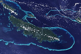
The lower corner of the scene shows part of the northwestern coast of the largest island in the archipelago, Vanatinai. Most of the island is densely covered in lowland rainforest, but clearing for agricultural land is widespread around the perimeter, especially in the northwest. The shallow waters
618:{{Information |Description={{en|1=The lower corner of the scene shows part of the northwestern coast of the largest island in the archipelago, Vanatinai. Most of the island is densely covered in lowland rainforest, but clearing for agricultural land is wi
158:
covering an extensive network of reefs are electric blue. A sinuous channel of deep, clear water (image center) connects a partially enclosed lagoon north of
Vanatinai with the bay south of Yeina Island.
369:
446:
430:
434:
426:
522:
442:
438:
69:
65:
61:
57:
53:
47:
114:
82:
449:"}},"text\/plain":{"en":{"P459":"work of the federal government of the United States"}}}}": -->
348:
joint project implies that all materials created by its probe are copyrighted and require permission for commercial non-educational use.
297:
507:
963:
This file contains additional information, probably added from the digital camera or scanner used to create or digitize it.
472:
365:
345:
485:
456:
323:
532:
500:
415:
492:
999:
355:
308:
966:
If the file has been modified from its original state, some details may not fully reflect the modified file.
930:
600:
595:
73:
42:
373:
376:
states that all of the images in the photo gallery are in the public domain "Unless otherwise noted."
187:
NASA image by Jesse Allen and Rob Simmon, using data provided by the United States
Geological Survey.
665:
628:
The following pages on the
English Knowledge use this file (pages on other projects are not listed):
319:
122:
349:
304:
900:
177:
8:
360:
336:
330:
252:
248:
611:
109:
840:
755:
405:
950:
945:
243:. NASA copyright policy states that "NASA material is not protected by copyright
235:
637:
785:
1014:
542:
466:
256:
293:
655:
825:
568:
Click on a date/time to view the file as it appeared at that time.
327:
322:
data may be copyrighted if they are not explicitly produced by the
795:
890:
705:
931:
Wikidata:WikiProject
Invasion biology/Wikidata lists/Habitats
240:
935:
870:
685:
632:
775:
805:
303:
The NASA website hosts a large number of images from the
167:
97:
725:
399:
Add a one-line explanation of what this file represents
765:
745:
735:
710:
239:
in the United States because it was solely created by
87:(3,600 × 2,400 pixels, file size: 2.93 MB, MIME type:
880:
626:
925:
920:
646:
566:
121:
Commons is a freely licensed media file repository.
850:
815:
675:
508:
work of the federal government of the United States
447:
work of the federal government of the United States
311:, and other non-American space agencies. These are
715:
296:, insignia and emblems is restricted per U.S. law
910:
860:
835:
695:
102:
163:
144:
183:
173:
14:
648:The following other wikis use this file:
226:
133:
368:(NSSDC) site has been known to host
359:(APOD) web site may be copyrighted.
221:
147:Vanatinai, Louisiade Archipelago.jpg
559:
13:
961:
404:
398:
366:National Space Science Data Center
274:
263:
151:
134:
80:
1031:
968:
403:
627:
389:
225:
101:
31:
21:
386:
152:
877:Usage on simple.wikipedia.org
643:
563:
385:
26:
1:
1000:Adobe Photoshop CS3 Macintosh
841:Veidne:Vai tu zināji/Arhīvs10
194:Instrument: Landsat 7 - ETM+
36:
623:
411:Items portrayed in this file
356:Astronomy Picture of the Day
197:
7:
958:
907:Usage on vls.wikipedia.org
857:Usage on pap.wikipedia.org
682:Usage on ceb.wikipedia.org
662:Usage on arz.wikipedia.org
10:
1036:
942:Usage on zh.wikipedia.org
917:Usage on www.wikidata.org
897:Usage on vi.wikipedia.org
887:Usage on uk.wikipedia.org
867:Usage on pl.wikipedia.org
847:Usage on nl.wikipedia.org
832:Usage on lv.wikipedia.org
822:Usage on kw.wikipedia.org
812:Usage on it.wikipedia.org
802:Usage on id.wikipedia.org
792:Usage on ia.wikipedia.org
782:Usage on he.wikipedia.org
772:Usage on fr.wikipedia.org
762:Usage on fi.wikipedia.org
752:Usage on fa.wikipedia.org
742:Usage on et.wikipedia.org
732:Usage on es.wikipedia.org
722:Usage on eo.wikipedia.org
702:Usage on de.wikipedia.org
692:Usage on cy.wikipedia.org
672:Usage on ca.wikipedia.org
652:Usage on ar.wikipedia.org
253:NASA copyright policy page
141:
136:
1006:File change date and time
560:
16:
493:United States of America
439:United States of America
388:
108:This is a file from the
41:
617:
486:applies to jurisdiction
435:applies to jurisdiction
353:Images featured on the
166:
112:. Information from its
1009:11:42, 8 December 2008
826:Krib (tirfurv arvorel)
320:Hubble Space Telescope
279:
268:
178:NASA Earth Observatory
115:description page there
46:Size of this preview:
980:Horizontal resolution
346:SOHO (ESA & NASA)
315:in the public domain.
278:
267:
596:12:34, 26 April 2009
501:determination method
443:determination method
309:Russian space agency
257:JPL Image Use Policy
233:This file is in the
74:3,600 × 2,400 pixels
70:2,560 × 1,707 pixels
988:Vertical resolution
796:Scolio (geographia)
370:copyrighted content
318:Materials based on
52:Other resolutions:
901:Rạn san hô chắn bờ
280:
269:
66:1,280 × 853 pixels
62:1,024 × 683 pixels
1023:
1022:
706:Riff (Geographie)
644:Global file usage
621:
397:
383:
382:
374:photo gallery FAQ
287:
249:Template:PD-USGov
220:
219:
191:
190:
130:
129:
110:Wikimedia Commons
32:Global file usage
1027:
969:
608:
570:
510:
505:
495:
490:
457:copyright status
427:copyright status
395:
339:
333:
283:
277:
266:
229:
228:
222:
216:
213:
210:
207:
202:
201:
169:
156:
148:
142:
126:
105:
104:
98:
92:
90:
77:
58:640 × 427 pixels
54:320 × 213 pixels
48:800 × 533 pixels
1035:
1034:
1030:
1029:
1028:
1026:
1025:
1024:
957:
936:Lexeme:L1231273
642:
629:
622:
614:
606:
562:
561:
558:
557:
556:
555:
554:
553:
552:
551:
549:
548:13 January 2002
539:
538:
537:
535:
520:
519:
518:
517:
516:
515:
514:
513:
512:
511:
506:
503:
497:
496:
491:
488:
479:
478:
477:
475:
463:
462:
461:
459:
424:
423:
422:
421:
420:
418:
402:
401:
400:
379:
337:
331:
313:not necessarily
275:
264:
214:
211:
208:
205:
200:
192:
168:13 January 2002
159:
146:
139:
132:
131:
120:
119:
118:is shown below.
94:
88:
86:
79:
78:
51:
12:
11:
5:
1033:
1021:
1020:
1017:
1011:
1010:
1007:
1003:
1002:
997:
993:
992:
989:
985:
984:
981:
977:
976:
973:
960:
956:
955:
954:
953:
948:
940:
939:
938:
933:
928:
923:
915:
914:
913:
905:
904:
903:
895:
894:
893:
885:
884:
883:
875:
874:
873:
871:Tagula (wyspa)
865:
864:
863:
855:
854:
853:
845:
844:
843:
838:
830:
829:
828:
820:
819:
818:
810:
809:
808:
800:
799:
798:
790:
789:
788:
780:
779:
778:
770:
769:
768:
760:
759:
758:
750:
749:
748:
740:
739:
738:
730:
729:
728:
720:
719:
718:
713:
708:
700:
699:
698:
690:
689:
688:
680:
679:
678:
670:
669:
668:
660:
659:
658:
645:
641:
640:
635:
625:
620:
619:
616:
612:
609:
605:3,600 × 2,400
603:
598:
593:
589:
588:
585:
582:
579:
576:
573:
565:
550:
547:
545:
544:
543:
541:
540:
536:
531:
529:
528:
527:
526:
524:
499:
498:
484:
483:
482:
481:
480:
476:
471:
469:
468:
467:
465:
464:
460:
455:
453:
452:
451:
450:
448:
444:
440:
436:
432:
428:
419:
414:
412:
409:
408:
407:
406:
394:
393:
390:
387:
381:
380:
378:
377:
362:
351:
342:
316:
301:
289:
281:
271:
270:
261:
230:
218:
217:
199:
196:
189:
188:
185:
181:
180:
175:
171:
170:
165:
161:
160:
149:
140:
138:
135:
128:
127:
106:
96:
95:
45:
40:
39:
34:
29:
24:
19:
9:
6:
4:
3:
2:
1032:
1018:
1016:
1013:
1012:
1008:
1005:
1004:
1001:
998:
996:Software used
995:
994:
990:
987:
986:
982:
979:
978:
974:
971:
970:
967:
964:
952:
949:
947:
944:
943:
941:
937:
934:
932:
929:
927:
924:
922:
919:
918:
916:
912:
909:
908:
906:
902:
899:
898:
896:
892:
889:
888:
886:
882:
879:
878:
876:
872:
869:
868:
866:
862:
859:
858:
856:
852:
849:
848:
846:
842:
839:
837:
834:
833:
831:
827:
824:
823:
821:
817:
814:
813:
811:
807:
804:
803:
801:
797:
794:
793:
791:
787:
784:
783:
781:
777:
776:Tagula Island
774:
773:
771:
767:
764:
763:
761:
757:
754:
753:
751:
747:
744:
743:
741:
737:
734:
733:
731:
727:
724:
723:
721:
717:
714:
712:
709:
707:
704:
703:
701:
697:
694:
693:
691:
687:
686:Sudest Island
684:
683:
681:
677:
674:
673:
671:
667:
664:
663:
661:
657:
654:
653:
651:
650:
649:
639:
638:Tagula Island
636:
634:
631:
630:
615:
610:
604:
602:
599:
597:
594:
591:
590:
586:
583:
580:
577:
574:
572:
571:
569:
546:
534:
530:
509:
502:
494:
487:
474:
473:public domain
470:
458:
454:
431:public domain
417:
413:
410:
391:
384:
375:
371:
367:
363:
361:
358:
357:
352:
350:
347:
343:
340:
338:{{Cc-Hubble}}
334:
332:{{PD-Hubble}}
328:
325:
321:
317:
314:
310:
306:
302:
299:
295:
291:
290:
288:
286:
282:
273:
272:
262:
260:
258:
254:
250:
246:
242:
238:
237:
236:public domain
231:
224:
223:
209:Public domain
206:Public domain
204:
203:
195:
186:
182:
179:
176:
172:
162:
155:
150:
143:
124:
117:
116:
111:
107:
100:
99:
93:
84:
83:Original file
75:
71:
67:
63:
59:
55:
49:
44:
38:
35:
33:
30:
28:
25:
23:
20:
18:
15:
1019:Uncalibrated
965:
962:
806:Pulau Tagula
647:
613:Originalwana
567:
564:File history
354:
312:
284:
245:unless noted
244:
234:
232:
193:
153:
123:You can help
113:
81:
22:File history
1015:Color space
972:Orientation
298:14 CFR 1221
145:Description
726:Vanatinajo
624:File usage
581:Dimensions
294:NASA logos
89:image/jpeg
27:File usage
766:Vanatinai
746:Vanatinai
736:Vanatinai
711:Vanatinai
666:ڤاناتيناى
607:(2.93 MB)
578:Thumbnail
575:Date/Time
533:inception
523:inception
329:See also
285:Warnings:
198:Licensing
154:English:
959:Metadata
392:Captions
247:". (See
37:Metadata
926:Q477164
921:Q184358
592:current
587:Comment
416:depicts
396:English
292:Use of
137:Summary
85:
991:72 dpi
983:72 dpi
975:Normal
851:Sudest
816:Tagula
756:آبسنگ
676:Escull
372:. Its
305:Soviet
184:Author
174:Source
786:שונית
716:Yeina
324:STScI
215:false
212:false
951:耶伊納島
946:塔古拉島
881:Reef
836:Rifs
696:Riff
656:شعاب
633:Reef
584:User
364:The
344:The
335:and
241:NASA
164:Date
17:File
911:Rif
891:Риф
861:Ref
255:or
504::
489::
259:.)
251:,
72:|
68:|
64:|
60:|
56:|
50:.
341:.
326:.
307:/
300:.
125:.
91:)
76:.
Text is available under the Creative Commons Attribution-ShareAlike License. Additional terms may apply.
