875:"}},"text\/plain":{"en":{"":"coordinates of depicted place"}}},"{\"value\":{\"latitude\":51.8883,\"longitude\":0.898,\"altitude\":null,\"precision\":0.0001,\"globe\":\"http:\\\/\\\/www.wikidata.org\\\/entity\\\/Q2\"},\"type\":\"globecoordinate\"}":{"text\/html":{"en":{"P9149":"51\u00b053'17.9"N, 0\u00b053'52.8"E"}},"text\/plain":{"en":{"P9149":"51\u00b053'17.9\"N, 0\u00b053'52.8\"E"}}},"{\"value\":{\"entity-type\":\"property\",\"numeric-id\":7787,\"id\":\"P7787\"},\"type\":\"wikibase-entityid\"}":{"text\/html":{"en":{"":"
535:"}},"text\/plain":{"en":{"":"author name string"}}},"{\"value\":\"David Hawgood\",\"type\":\"string\"}":{"text\/html":{"en":{"P2093":"David Hawgood"}},"text\/plain":{"en":{"P2093":"David Hawgood"}}},"{\"value\":{\"entity-type\":\"property\",\"numeric-id\":3831,\"id\":\"P3831\"},\"type\":\"wikibase-entityid\"}":{"text\/html":{"en":{"":"
718:"}},"text\/plain":{"en":{"":"inception"}}},"{\"value\":{\"time\":\"+2006-06-15T00:00:00Z\",\"timezone\":0,\"before\":0,\"after\":0,\"precision\":11,\"calendarmodel\":\"http:\\\/\\\/www.wikidata.org\\\/entity\\\/Q1985727\"},\"type\":\"time\"}":{"text\/html":{"en":{"P571":"15 June 2006"}},"text\/plain":{"en":{"P571":"15 June 2006"}}}}": -->
43:
752:
519:
871:
282:
328:
366:
371:
87:
1025:
531:"}},"text\/plain":{"en":{"P2699":"https:\/\/www.geograph.org.uk\/profile\/560"}}},"{\"value\":{\"entity-type\":\"property\",\"numeric-id\":2093,\"id\":\"P2093\"},\"type\":\"wikibase-entityid\"}":{"text\/html":{"en":{"":"
760:"}},"text\/plain":{"en":{"P7482":"file available on the internet"}}},"{\"value\":{\"entity-type\":\"property\",\"numeric-id\":137,\"id\":\"P137\"},\"type\":\"wikibase-entityid\"}":{"text\/html":{"en":{"":"
768:"}},"text\/plain":{"en":{"P137":"Geograph Britain and Ireland"}}},"{\"value\":{\"entity-type\":\"property\",\"numeric-id\":7384,\"id\":\"P7384\"},\"type\":\"wikibase-entityid\"}":{"text\/html":{"en":{"":"
539:"}},"text\/plain":{"en":{"":"object of statement has role"}}},"{\"value\":{\"entity-type\":\"item\",\"numeric-id\":33231,\"id\":\"Q33231\"},\"type\":\"wikibase-entityid\"}":{"text\/html":{"en":{"P3831":"
943:"}},"text\/plain":{"en":{"":"location of creation"}}},"{\"value\":{\"entity-type\":\"item\",\"numeric-id\":589620,\"id\":\"Q589620\"},\"type\":\"wikibase-entityid\"}":{"text\/html":{"en":{"P1071":"
674:"}},"text\/plain":{"en":{"":"copyright license"}}},"{\"value\":{\"entity-type\":\"item\",\"numeric-id\":19068220,\"id\":\"Q19068220\"},\"type\":\"wikibase-entityid\"}":{"text\/html":{"en":{"P275":"
630:"}},"text\/plain":{"en":{"":"copyright status"}}},"{\"value\":{\"entity-type\":\"item\",\"numeric-id\":50423863,\"id\":\"Q50423863\"},\"type\":\"wikibase-entityid\"}":{"text\/html":{"en":{"P6216":"
756:"}},"text\/plain":{"en":{"":"source of file"}}},"{\"value\":{\"entity-type\":\"item\",\"numeric-id\":74228490,\"id\":\"Q74228490\"},\"type\":\"wikibase-entityid\"}":{"text\/html":{"en":{"P7482":"
476:"}},"text\/plain":{"en":{"":"depicts"}}},"{\"value\":{\"entity-type\":\"item\",\"numeric-id\":17545337,\"id\":\"Q17545337\"},\"type\":\"wikibase-entityid\"}":{"text\/html":{"en":{"P180":"
764:"}},"text\/plain":{"en":{"":"operator"}}},"{\"value\":{\"entity-type\":\"item\",\"numeric-id\":1503119,\"id\":\"Q1503119\"},\"type\":\"wikibase-entityid\"}":{"text\/html":{"en":{"P137":"
879:"}},"text\/plain":{"en":{"":"heading"}}},"{\"value\":{\"amount\":\"+45\",\"unit\":\"http:\\\/\\\/www.wikidata.org\\\/entity\\\/Q28390\"},\"type\":\"quantity\"}":{"text\/html":{"en":{"P7787":"45
776:"}},"text\/plain":{"en":{"P7384":"189178"}}},"{\"value\":{\"entity-type\":\"property\",\"numeric-id\":973,\"id\":\"P973\"},\"type\":\"wikibase-entityid\"}":{"text\/html":{"en":{"":"
523:"}},"text\/plain":{"en":{"":"creator"}}},"{\"value\":{\"entity-type\":\"property\",\"numeric-id\":2699,\"id\":\"P2699\"},\"type\":\"wikibase-entityid\"}":{"text\/html":{"en":{"":"
939:
527:"}},"text\/plain":{"en":{"":"URL"}}},"{\"value\":\"https:\\\/\\\/www.geograph.org.uk\\\/profile\\\/560\",\"type\":\"string\"}":{"text\/html":{"en":{"P2699":"
772:"}},"text\/plain":{"en":{"":"geograph.org.uk image ID"}}},"{\"value\":\"189178\",\"type\":\"string\"}":{"text\/html":{"en":{"P7384":"
53:
47:
98:
66:
418:– You must give appropriate credit, provide a link to the license, and indicate if changes were made. You may do so in any reasonable manner, but not in any way that suggests the licensor endorses you or your use.
1042:== {{int:filedesc}} == {{Information |description={{en|1=Tymperleys, 15th Century house in Colchester. This timber framed 15th century house is now a clock museum.}} |date=2006-06-15 |source=From |
265:
773:
757:
675:
631:
477:
765:
944:
540:
940:
876:
872:
769:
753:
627:
536:
532:
524:
781:
777:
761:
715:
671:
520:
473:
528:
1256:
1056:
1035:
1024:
1019:
57:
42:
678:"}},"text\/plain":{"en":{"P275":"Creative Commons Attribution-ShareAlike 2.0 Generic"}}}}": -->
784:"}},"text\/plain":{"en":{"P973":"https:\/\/www.geograph.org.uk\/photo\/189178"}}}}": -->
1119:
807:
701:
657:
506:
275:
827:
335:
1142:
This file contains additional information, probably added from the digital camera or scanner used to create or digitize it.
970:
425:
612:
954:
917:
890:
835:
791:
641:
605:
592:
577:
850:
820:
725:
685:
550:
490:
1287:
381:
1145:
If the file has been modified from its original state, some details may not fully reflect the modified file.
1061:
424:– If you remix, transform, or build upon the material, you must distribute your contributions under the
342:
on the
Geograph website for the photographer's contact details. The copyright on this image is owned by
543:"}},"text\/plain":{"en":{"P3831":"photographer"}}}}": -->
298:
149:
634:"}},"text\/plain":{"en":{"P6216":"copyrighted"}}}}": -->
303:
154:
1052:
The following pages on the
English Knowledge use this file (pages on other projects are not listed):
947:"}},"text\/plain":{"en":{"P1071":"Colchester"}}}}": -->
883:"}},"text\/plain":{"en":{"P7787":"45 degree"}}}}": -->
480:"}},"text\/plain":{"en":{"P180":"Tymperleys"}}}}": -->
106:
220:
141:
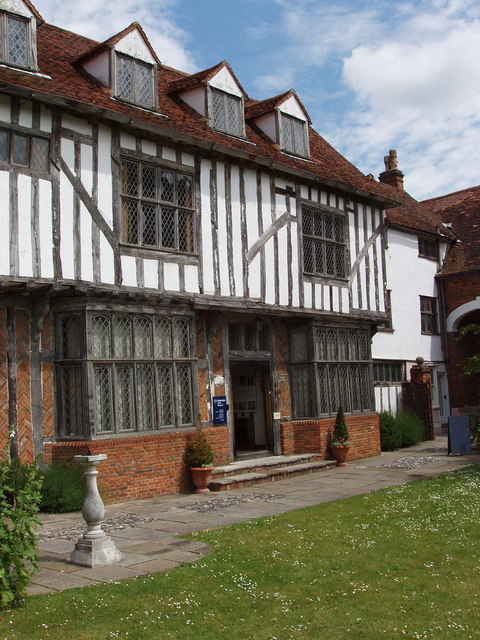
Tymperleys, a timber-framed 15th-century house in
Colchester, Essex. It is now a clock museum.
1306:
857:
842:
378:
204:
584:
8:
1342:
1162:
322:
281:
1407:
347:
93:
1378:
1324:
1179:
1417:
1388:
1219:
183:
131:
Tymperleys, 15th
Century house in Colchester - geograph.org.uk - 189178.jpg
193:
1352:
964:
900:
801:
735:
695:
651:
560:
500:
327:
1199:
1172:
339:
1427:
1189:
992:
Click on a date/time to view the file as it appeared at that time.
267:
1109:
1089:
1079:
252:
51° 53′ 18″ N, 0° 53′ 53″ E
172:
81:
1099:
466:
Add a one-line explanation of what this file represents
1129:
1050:
1070:
990:
105:
Commons is a freely licensed media file repository.
702:
Creative
Commons Attribution-ShareAlike 2.0 Generic
676:
Creative
Commons Attribution-ShareAlike 2.0 Generic
1057:Grade II* listed buildings in Colchester (borough)
71:(480 × 640 pixels, file size: 114 KB, MIME type:
1347:Flash did not fire, compulsory flash suppression
1282:Creative program (biased toward depth of field)
435:https://creativecommons.org/licenses/by-sa/2.0
86:
441:Creative Commons Attribution-Share Alike 2.0
359:
168:
128:
782:https:\/\/www.geograph.org.uk\/photo\/189178
235:Tymperleys, 15th Century house in Colchester
216:Tymperleys, 15th Century house in Colchester
189:
178:
14:
880:
529:https:\/\/www.geograph.org.uk\/profile\/560
401:– to copy, distribute and transmit the work
1072:The following other wikis use this file:
858:https://www.geograph.org.uk/photo/189178
585:https://www.geograph.org.uk/profile/560
274:View this and other nearby images on:
227:
117:
346:and is licensed for reuse under the
242:
983:
382:Attribution-Share Alike 2.0 Generic
370:
365:
350:Attribution-ShareAlike 2.0 license.
13:
1140:
471:
465:
356:
333:
296:
147:
135:
118:
64:
1444:
1147:
470:
1210:Date and time of data generation
1051:
456:
412:Under the following conditions:
377:This file is licensed under the
369:
364:
358:
326:
280:
266:
258:
85:
31:
21:
1154:OLYMPUS DIGITAL CAMERA
453:
136:
1067:
987:
808:file available on the internet
758:file available on the internet
452:
334:This image was taken from the
26:
1:
891:coordinates of depicted place
873:coordinates of depicted place
36:
1047:
828:Geograph Britain and Ireland
766:Geograph Britain and Ireland
606:object of statement has role
537:object of statement has role
486:Items portrayed in this file
318:
7:
1298:Date and time of digitizing
1137:
1096:Usage on en.wikivoyage.org
1062:William Gilbert (physicist)
257:
10:
1449:
1126:Usage on www.wikidata.org
1116:Usage on sr.wikipedia.org
1106:Usage on es.wikipedia.org
1086:Usage on ca.wikipedia.org
1076:Usage on bs.wikipedia.org
426:same or compatible license
292:
233:David Hawgood /
214:David Hawgood /
143:
125:
120:
1263:File change date and time
984:
906:51°53'17.9"N, 0°53'52.8"E
16:
836:geograph.org.uk image ID
770:geograph.org.uk image ID
455:
392:
92:This is a file from the
41:
1362:Custom image processing
1041:
205:required by the license
171:
96:. Information from its
1020:19:32, 31 January 2010
340:this photograph's page
286:51.888300; 0.898000
99:description page there
46:Size of this preview:
1316:Maximum land aperture
1237:Horizontal resolution
955:location of creation
941:location of creation
1301:12:00, 15 June 2006
1271:Y and C positioning
1266:21:21, 15 June 2006
1245:Vertical resolution
1213:12:00, 15 June 2006
1163:OLYMPUS CORPORATION
1159:Camera manufacturer
407:– to adapt the work
297:This is a photo of
148:This is a photo of
52:Other resolutions:
1399:Scene capture type
1383:Auto white balance
1257:CAMEDIA Master 4.2
1184:1/400 sec (0.0025)
593:author name string
533:author name string
1436:
1435:
1068:Global file usage
1045:
882:
686:copyright license
672:copyright license
464:
355:
354:
338:collection. See
313:
312:
291:
290:
240:
239:
208:
164:
163:
114:
113:
94:Wikimedia Commons
32:Global file usage
1440:
1279:Exposure Program
1173:X-3,C-60Z
1148:
1032:
994:
928:
927:
922:
860:
855:
851:described at URL
845:
840:
830:
825:
778:described at URL
642:copyright status
628:copyright status
615:
610:
600:
597:
587:
582:
462:
448:
445:
442:
439:
436:
428:as the original.
390:
379:Creative Commons
373:
372:
368:
367:
362:
361:
348:Creative Commons
336:Geograph project
330:
323:
306:
293:
287:
284:
270:
269:
263:
262:
261:
255:
254:
243:
202:
174:
157:
144:
140:
132:
126:
110:
89:
88:
82:
76:
74:
61:
58:480 × 640 pixels
54:180 × 240 pixels
48:450 × 600 pixels
1448:
1447:
1443:
1442:
1441:
1439:
1438:
1437:
1319:3 APEX (f/2.83)
1136:
1120:Вилијам Гилберт
1110:William Gilbert
1090:William Gilbert
1080:William Gilbert
1066:
1053:
1046:
1038:
1030:
986:
985:
982:
981:
980:
979:
978:
977:
976:
975:
973:
961:
960:
959:
957:
938:
937:
936:
935:
934:
933:
932:
931:
930:
929:
925:
923:
920:
911:
910:
909:
907:
897:
896:
895:
893:
870:
869:
868:
867:
866:
865:
864:
863:
862:
861:
856:
853:
847:
846:
841:
838:
832:
831:
826:
823:
814:
813:
812:
810:
798:
797:
796:
794:
751:
750:
749:
748:
747:
746:
745:
744:
742:
732:
731:
730:
728:
713:
712:
711:
710:
709:
708:
707:
706:
704:
692:
691:
690:
688:
669:
668:
667:
666:
665:
664:
663:
662:
660:
648:
647:
646:
644:
625:
624:
623:
622:
621:
620:
619:
618:
617:
616:
611:
608:
602:
601:
598:
595:
589:
588:
583:
580:
571:
570:
569:
567:
557:
556:
555:
553:
518:
517:
516:
515:
514:
513:
512:
511:
509:
497:
496:
495:
493:
469:
468:
467:
450:
449:
446:
443:
440:
437:
434:
433:
391:
388:
385:
374:
351:
321:
308:
302:
299:listed building
285:
259:
250:
249:
246:Object location
241:
230:
223:
211:
184:geograph.org.uk
159:
153:
150:listed building
142:
130:
123:
116:
115:
104:
103:
102:is shown below.
78:
72:
70:
63:
62:
51:
12:
11:
5:
1446:
1434:
1433:
1430:
1424:
1423:
1420:
1414:
1413:
1410:
1404:
1403:
1400:
1396:
1395:
1392:
1385:
1384:
1381:
1375:
1374:
1371:
1367:
1366:
1365:Custom process
1363:
1359:
1358:
1355:
1349:
1348:
1345:
1339:
1338:
1335:
1331:
1330:
1327:
1321:
1320:
1317:
1313:
1312:
1309:
1303:
1302:
1299:
1295:
1294:
1291:
1284:
1283:
1280:
1276:
1275:
1272:
1268:
1267:
1264:
1260:
1259:
1254:
1250:
1249:
1246:
1242:
1241:
1238:
1234:
1233:
1230:
1226:
1225:
1222:
1215:
1214:
1211:
1207:
1206:
1203:
1196:
1195:
1192:
1186:
1185:
1182:
1176:
1175:
1170:
1166:
1165:
1160:
1156:
1155:
1152:
1139:
1135:
1134:
1133:
1132:
1124:
1123:
1122:
1114:
1113:
1112:
1104:
1103:
1102:
1094:
1093:
1092:
1084:
1083:
1082:
1069:
1065:
1064:
1059:
1049:
1044:
1043:
1040:
1036:
1033:
1027:
1022:
1017:
1013:
1012:
1009:
1006:
1003:
1000:
997:
989:
974:
969:
967:
966:
965:
963:
962:
958:
953:
951:
950:
949:
948:
946:
942:
916:
915:
914:
913:
912:
908:
905:
903:
902:
901:
899:
898:
894:
889:
887:
886:
885:
884:
878:
874:
849:
848:
834:
833:
819:
818:
817:
816:
815:
811:
806:
804:
803:
802:
800:
799:
795:
792:source of file
790:
788:
787:
786:
785:
783:
779:
775:
771:
767:
763:
759:
755:
754:source of file
743:
740:
738:
737:
736:
734:
733:
729:
724:
722:
721:
720:
719:
717:
705:
700:
698:
697:
696:
694:
693:
689:
684:
682:
681:
680:
679:
677:
673:
661:
656:
654:
653:
652:
650:
649:
645:
640:
638:
637:
636:
635:
633:
629:
604:
603:
591:
590:
576:
575:
574:
573:
572:
568:
565:
563:
562:
561:
559:
558:
554:
549:
547:
546:
545:
544:
542:
538:
534:
530:
526:
522:
510:
505:
503:
502:
501:
499:
498:
494:
489:
487:
484:
483:
482:
481:
479:
475:
461:
460:
457:
454:
432:
431:
430:
429:
419:
410:
409:
408:
402:
395:You are free:
386:
376:
375:
357:
353:
352:
331:
320:
317:
311:
310:
289:
288:
278:
272:
247:
238:
237:
231:
228:
225:
224:
219:
212:
209:
197:
196:
191:
187:
186:
180:
176:
175:
170:
166:
165:
162:
161:
133:
124:
122:
119:
112:
111:
90:
80:
79:
45:
40:
39:
34:
29:
24:
19:
9:
6:
4:
3:
2:
1445:
1431:
1429:
1426:
1425:
1421:
1419:
1416:
1415:
1411:
1409:
1406:
1405:
1401:
1398:
1397:
1393:
1390:
1387:
1386:
1382:
1380:
1379:White balance
1377:
1376:
1373:Auto exposure
1372:
1370:Exposure mode
1369:
1368:
1364:
1361:
1360:
1356:
1354:
1351:
1350:
1346:
1344:
1341:
1340:
1336:
1333:
1332:
1328:
1326:
1325:Metering mode
1323:
1322:
1318:
1315:
1314:
1310:
1308:
1307:Exposure bias
1305:
1304:
1300:
1297:
1296:
1292:
1289:
1286:
1285:
1281:
1278:
1277:
1273:
1270:
1269:
1265:
1262:
1261:
1258:
1255:
1253:Software used
1252:
1251:
1247:
1244:
1243:
1239:
1236:
1235:
1231:
1228:
1227:
1223:
1221:
1217:
1216:
1212:
1209:
1208:
1204:
1201:
1198:
1197:
1193:
1191:
1188:
1187:
1183:
1181:
1180:Exposure time
1178:
1177:
1174:
1171:
1168:
1167:
1164:
1161:
1158:
1157:
1153:
1150:
1149:
1146:
1143:
1131:
1128:
1127:
1125:
1121:
1118:
1117:
1115:
1111:
1108:
1107:
1105:
1101:
1098:
1097:
1095:
1091:
1088:
1087:
1085:
1081:
1078:
1077:
1075:
1074:
1073:
1063:
1060:
1058:
1055:
1054:
1039:
1034:
1028:
1026:
1023:
1021:
1018:
1015:
1014:
1010:
1007:
1004:
1001:
998:
996:
995:
993:
972:
968:
956:
952:
919:
904:
892:
888:
859:
852:
844:
837:
829:
822:
809:
805:
793:
789:
739:
727:
723:
703:
699:
687:
683:
659:
655:
643:
639:
614:
607:
599:David Hawgood
594:
586:
579:
564:
552:
548:
508:
504:
492:
488:
485:
458:
451:
438:CC BY-SA 2.0
427:
423:
420:
417:
414:
413:
411:
406:
403:
400:
397:
396:
394:
393:
389:David Hawgood
387:Attribution:
383:
380:
363:
349:
345:
344:David Hawgood
341:
337:
332:
329:
325:
324:
316:
315:
309:
305:
300:
295:
294:
283:
279:
277:
276:OpenStreetMap
273:
271:
253:
248:
245:
244:
236:
232:
226:
222:
218: /
217:
213:
206:
201:
199:
198:
195:
194:David Hawgood
192:
188:
185:
181:
177:
167:
160:
156:
151:
146:
145:
139:
134:
127:
108:
101:
100:
95:
91:
84:
83:
77:
68:
67:Original file
59:
55:
49:
44:
38:
35:
33:
30:
28:
25:
23:
20:
18:
15:
1389:Digital zoom
1334:Light source
1220:focal length
1169:Camera model
1144:
1141:
1071:
991:
988:File history
741:15 June 2006
613:photographer
541:photographer
421:
415:
404:
398:
343:
314:
256:
234:
221:CC BY-SA 2.0
215:
173:15 June 2006
137:
107:You can help
97:
65:
22:File history
1353:Color space
1229:Orientation
1151:Image title
1037:GeographBot
658:copyrighted
632:copyrighted
422:share alike
416:attribution
200:Attribution
129:Description
1418:Saturation
1100:Colchester
1048:File usage
1029:480 × 640
1005:Dimensions
971:Colchester
945:Colchester
566:some value
507:Tymperleys
478:Tymperleys
73:image/jpeg
27:File usage
1428:Sharpness
1200:ISO speed
1130:Q17545337
1002:Thumbnail
999:Date/Time
726:inception
716:inception
319:Licensing
229:InfoField
210:InfoField
138:English:
1408:Contrast
1402:Standard
1274:Co-sited
1190:F-number
1138:Metadata
1031:(114 KB)
821:operator
762:operator
459:Captions
405:to remix
399:to share
384:license.
37:Metadata
1337:Unknown
1329:Pattern
1290:version
1248:200 dpi
1240:200 dpi
1016:current
1011:Comment
918:heading
877:heading
551:creator
521:creator
491:depicts
474:depicts
463:English
304:1169553
301:number
155:1169553
152:number
121:Summary
69:
1432:Normal
1422:Normal
1412:Normal
1232:Normal
1224:7.8 mm
1202:rating
926:degree
881:degree
843:189178
774:189178
264:
190:Author
179:Source
1391:ratio
1343:Flash
1218:Lens
1194:f/5.6
182:From
1357:sRGB
1293:2.21
1288:Exif
1008:User
447:true
444:true
169:Date
17:File
924:45
578:URL
525:URL
1205:64
921::
854::
839::
824::
609::
596::
581::
56:|
50:.
1394:1
1311:0
307:.
207:)
203:(
158:.
109:.
75:)
60:.
Text is available under the Creative Commons Attribution-ShareAlike License. Additional terms may apply.
_heading:45.00&language=en)
