558:"}},"text\/plain":{"en":{"":"inception"}}},"{\"value\":{\"time\":\"+2023-04-12T00:00:00Z\",\"timezone\":0,\"before\":0,\"after\":0,\"precision\":11,\"calendarmodel\":\"http:\\\/\\\/www.wikidata.org\\\/entity\\\/Q1985727\"},\"type\":\"time\"}":{"text\/html":{"en":{"P571":"12 April 2023"}},"text\/plain":{"en":{"P571":"12 April 2023"}}}}": -->
316:
43:
270:
322:
327:
95:
596:"}},"text\/plain":{"en":{"":"media type"}}},"{\"value\":\"image\\\/svg+xml\",\"type\":\"string\"}":{"text\/html":{"en":{"P1163":"image\/svg+xml"}},"text\/plain":{"en":{"P1163":"image\/svg+xml"}}}}": -->
514:"}},"text\/plain":{"en":{"":"copyright license"}}},"{\"value\":{\"entity-type\":\"item\",\"numeric-id\":19068220,\"id\":\"Q19068220\"},\"type\":\"wikibase-entityid\"}":{"text\/html":{"en":{"P275":"
470:"}},"text\/plain":{"en":{"":"copyright status"}}},"{\"value\":{\"entity-type\":\"item\",\"numeric-id\":50423863,\"id\":\"Q50423863\"},\"type\":\"wikibase-entityid\"}":{"text\/html":{"en":{"P6216":"
592:
368:– You must give appropriate credit, provide a link to the license, and indicate if changes were made. You may do so in any reasonable manner, but not in any way that suggests the licensor endorses you or your use.
289:
The ODbL does not require any particular license for maps produced from ODbL data. Prior to 1 August 2020, map tiles produced by the OpenStreetMap
Foundation were licensed under the
515:
471:
593:
467:
555:
511:
798:
793:
518:"}},"text\/plain":{"en":{"P275":"Creative Commons Attribution-ShareAlike 2.0 Generic"}}}}": -->
69:
246:
65:
61:
57:
53:
47:
106:
541:
497:
78:
689:
Uploaded a work by Open Street Map contributors from https://www.openstreetmap.org/#map=11/-19.3037/146.7928 with UploadWizard
849:
This file contains additional information, probably added from the digital camera or scanner used to create or digitize it.
375:
603:
481:
565:
525:
456:
337:
852:
If the file has been modified from its original state, some details may not fully reflect the modified file.
708:
262:). Map tiles are licensed under the Creative Commons Attribution-ShareAlike 2.0 license (CC-BY-SA 2.0).
374:– If you remix, transform, or build upon the material, you must distribute your contributions under the
748:
474:"}},"text\/plain":{"en":{"P6216":"copyrighted"}}}}": -->
699:
The following pages on the
English Knowledge use this file (pages on other projects are not listed):
753:
743:
821:
114:
768:
758:
836:
816:
778:
728:
703:
682:
671:
666:
42:
763:
723:
334:
207:
This map may be incomplete, and may contain errors. Don't rely solely on it for navigation.
831:
168:
8:
788:
773:
733:
783:
738:
718:
713:
409:
101:
446:
290:
282:
202:
255:
613:
575:
535:
491:
259:
269:
264:
639:
Click on a date/time to view the file as it appeared at that time.
293:. Maps produced by other people may be subject to other licences.
278:
225:
83:(SVG file, nominally 294 × 385 pixels, file size: 3.42 MB)
158:
89:
418:
If inappropriate please set warp_status = skip to hide.
169:
https://www.openstreetmap.org/#map=11/-19.3037/146.7928
697:
807:
637:
149:
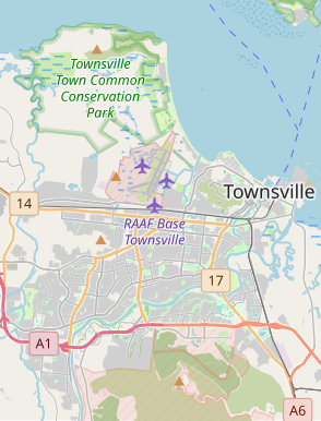
Locator map of the city of
Townsville in Queensland.
113:
Commons is a freely licensed media file repository.
542:
Creative
Commons Attribution-ShareAlike 2.0 Generic
516:
Creative
Commons Attribution-ShareAlike 2.0 Generic
404:
837:Module:Location map/data/Australia Townsville/doc
822:Module:Location map/data/Australia Townsville/doc
799:Module:Location map/data/Australia Townsville/doc
440:Locator map of Townsville, a city in Queensland.
385:https://creativecommons.org/licenses/by-sa/2.0
94:
832:Module:Location map/data/Australia Townsville
817:Module:Location map/data/Australia Townsville
794:Module:Location map/data/Australia Townsville
391:Creative Commons Attribution-Share Alike 2.0
315:
302:http://opendatacommons.org/licenses/odbl/1.0/
241:
213:
193:
154:
136:
231:
221:
174:
164:
14:
351:– to copy, distribute and transmit the work
46:Size of this PNG preview of this SVG file:
254:OpenStreetMap data is available under the
205:project data, collected by the community.
190:
809:The following other wikis use this file:
412:Georeference the map in Wikimaps Warper
125:
281:, which is made available under the
277:This work contains information from
630:
338:Attribution-Share Alike 2.0 Generic
326:
321:
13:
847:
445:
439:
312:
143:
126:
76:
881:
854:
444:
698:
430:
362:Under the following conditions:
333:This file is licensed under the
325:
320:
314:
268:
93:
31:
21:
427:
144:
813:Usage on simple.wikipedia.org
804:
634:
426:
26:
1:
410:
36:
694:
452:Items portrayed in this file
283:Open Database License (ODbL)
267:
185:
178:Open Street Map contributors
7:
844:
709:Belgian Gardens, Queensland
201:This map was created from
10:
886:
828:Usage on si.wikipedia.org
376:same or compatible license
236:OpenStreetMap contributors
196:Townsville locator map.svg
139:Townsville locator map.svg
133:
128:
749:Mount St John, Queensland
631:
16:
754:Mundingburra, Queensland
744:Mount Louisa, Queensland
429:
342:
100:This is a file from the
41:
688:
157:
104:. Information from its
769:Pallarenda, Queensland
759:North Ward, Queensland
107:description page there
779:Rowes Bay, Queensland
729:Currajong, Queensland
704:Annandale, Queensland
296:Open Database License
256:Open Database License
764:Oonoonba, Queensland
724:Cosgrove, Queensland
667:04:11, 12 April 2023
291:CC-BY-SA-2.0 license
70:1,564 × 2,048 pixels
789:Vincent, Queensland
774:Rosslea, Queensland
734:Douglas, Queensland
357:– to adapt the work
52:Other resolutions:
784:Stuart, Queensland
739:Kirwan, Queensland
719:Cluden, Queensland
217:(see file history)
66:782 × 1,024 pixels
873:
872:
805:Global file usage
714:Bohle, Queensland
692:
526:copyright license
512:copyright license
438:
423:
422:
419:
311:
310:
294:
250:
247:Reusing this file
226:openstreetmap.org
208:
182:
181:
122:
121:
102:Wikimedia Commons
32:Global file usage
877:
855:
684:Thiscouldbeauser
679:
641:
482:copyright status
468:copyright status
436:
417:
416:
414:
413:
398:
395:
392:
389:
386:
378:as the original.
335:Creative Commons
329:
328:
324:
323:
318:
317:
306:
303:
300:
297:
288:
272:
265:
244:
206:
197:
191:
160:
148:
140:
134:
118:
97:
96:
90:
84:
73:
62:586 × 768 pixels
58:366 × 480 pixels
54:183 × 240 pixels
48:294 × 385 pixels
885:
884:
880:
879:
878:
876:
875:
874:
843:
803:
700:
693:
685:
677:
633:
632:
629:
628:
627:
626:
625:
624:
623:
622:
620:
610:
609:
608:
606:
591:
590:
589:
588:
587:
586:
585:
584:
582:
572:
571:
570:
568:
553:
552:
551:
550:
549:
548:
547:
546:
544:
532:
531:
530:
528:
509:
508:
507:
506:
505:
504:
503:
502:
500:
488:
487:
486:
484:
465:
464:
463:
462:
461:
459:
443:
442:
441:
424:
411:
408:
400:
399:
396:
393:
390:
387:
384:
383:
341:
330:
304:
301:
298:
295:
237:
209:
195:
188:
183:
150:
138:
131:
124:
123:
112:
111:
110:is shown below.
86:
82:
75:
74:
51:
12:
11:
5:
883:
871:
870:
867:
863:
862:
859:
846:
842:
841:
840:
839:
834:
826:
825:
824:
819:
806:
802:
801:
796:
791:
786:
781:
776:
771:
766:
761:
756:
751:
746:
741:
736:
731:
726:
721:
716:
711:
706:
696:
691:
690:
687:
683:
680:
674:
669:
664:
660:
659:
656:
653:
650:
647:
644:
636:
621:
618:
616:
615:
614:
612:
611:
607:
602:
600:
599:
598:
597:
595:
583:
580:
578:
577:
576:
574:
573:
569:
564:
562:
561:
560:
559:
557:
545:
540:
538:
537:
536:
534:
533:
529:
524:
522:
521:
520:
519:
517:
513:
501:
496:
494:
493:
492:
490:
489:
485:
480:
478:
477:
476:
475:
473:
469:
460:
455:
453:
450:
449:
448:
447:
435:
434:
431:
428:
421:
420:
406:
405:Georeferencing
402:
401:
382:
381:
380:
379:
369:
360:
359:
358:
352:
345:You are free:
332:
331:
313:
309:
308:
275:
273:
251:
239:
238:
235:
233:
229:
228:
223:
219:
218:
215:
211:
210:
200:
198:
189:
187:
184:
180:
179:
176:
172:
171:
166:
162:
161:
156:
152:
151:
141:
132:
130:
127:
120:
119:
98:
88:
87:
45:
40:
39:
34:
29:
24:
19:
9:
6:
4:
3:
2:
882:
868:
865:
864:
860:
857:
856:
853:
850:
838:
835:
833:
830:
829:
827:
823:
820:
818:
815:
814:
812:
811:
810:
800:
797:
795:
792:
790:
787:
785:
782:
780:
777:
775:
772:
770:
767:
765:
762:
760:
757:
755:
752:
750:
747:
745:
742:
740:
737:
735:
732:
730:
727:
725:
722:
720:
717:
715:
712:
710:
707:
705:
702:
701:
686:
681:
675:
673:
670:
668:
665:
662:
661:
657:
654:
651:
648:
645:
643:
642:
640:
619:image/svg+xml
617:
605:
601:
581:12 April 2023
579:
567:
563:
543:
539:
527:
523:
499:
495:
483:
479:
458:
454:
451:
432:
425:
415:
407:
403:
388:CC BY-SA 2.0
377:
373:
370:
367:
364:
363:
361:
356:
353:
350:
347:
346:
344:
343:
339:
336:
319:
307:
292:
286:
284:
280:
279:OpenStreetMap
276:
274:
271:
266:
263:
261:
257:
252:
248:
243:
240:
234:
230:
227:
224:
220:
216:
212:
204:
203:OpenStreetMap
199:
192:
177:
173:
170:
167:
163:
159:12 April 2023
153:
147:
142:
135:
116:
109:
108:
103:
99:
92:
91:
85:
80:
79:Original file
71:
67:
63:
59:
55:
49:
44:
38:
35:
33:
30:
28:
25:
23:
20:
18:
15:
851:
848:
808:
638:
635:File history
371:
365:
354:
348:
287:
253:
145:
115:You can help
105:
77:
22:File history
498:copyrighted
472:copyrighted
372:share alike
366:attribution
194:Description
137:Description
695:File usage
676:294 × 385
652:Dimensions
604:media type
594:media type
242:Permission
27:File usage
678:(3.42 MB)
649:Thumbnail
646:Date/Time
566:inception
556:inception
186:Licensing
146:English:
845:Metadata
433:Captions
355:to remix
349:to share
340:license.
37:Metadata
663:current
658:Comment
457:depicts
437:English
260:details
232:Creator
129:Summary
81:
866:Height
222:Source
175:Author
165:Source
869:308pt
861:235pt
858:Width
655:User
397:true
394:true
305:true
299:ODbL
214:Date
155:Date
17:File
285:.
68:|
64:|
60:|
56:|
50:.
258:(
249:)
245:(
117:.
72:.
Text is available under the Creative Commons Attribution-ShareAlike License. Additional terms may apply.
