789:"}},"text\/plain":{"en":{"":"coordinates of depicted place"}}},"{\"value\":{\"latitude\":51.794226,\"longitude\":-0.78225,\"altitude\":null,\"precision\":1.0e-6,\"globe\":\"http:\\\/\\\/www.wikidata.org\\\/entity\\\/Q2\"},\"type\":\"globecoordinate\"}":{"text\/html":{"en":{"P9149":"51\u00b047'39.214"N, 0\u00b046'56.100"W"}},"text\/plain":{"en":{"P9149":"51\u00b047'39.214\"N, 0\u00b046'56.100\"W"}}},"{\"value\":{\"entity-type\":\"property\",\"numeric-id\":7787,\"id\":\"P7787\"},\"type\":\"wikibase-entityid\"}":{"text\/html":{"en":{"":"
449:"}},"text\/plain":{"en":{"":"author name string"}}},"{\"value\":\"sijon\",\"type\":\"string\"}":{"text\/html":{"en":{"P2093":"sijon"}},"text\/plain":{"en":{"P2093":"sijon"}}},"{\"value\":{\"entity-type\":\"property\",\"numeric-id\":3831,\"id\":\"P3831\"},\"type\":\"wikibase-entityid\"}":{"text\/html":{"en":{"":"
632:"}},"text\/plain":{"en":{"":"inception"}}},"{\"value\":{\"time\":\"+2006-10-29T00:00:00Z\",\"timezone\":0,\"before\":0,\"after\":0,\"precision\":11,\"calendarmodel\":\"http:\\\/\\\/www.wikidata.org\\\/entity\\\/Q1985727\"},\"type\":\"time\"}":{"text\/html":{"en":{"P571":"29 October 2006"}},"text\/plain":{"en":{"P571":"29 October 2006"}}}}": -->
666:
231:
223:
785:
269:
307:
312:
895:
72:
445:"}},"text\/plain":{"en":{"P2699":"https:\/\/www.geograph.org.uk\/profile\/8036"}}},"{\"value\":{\"entity-type\":\"property\",\"numeric-id\":2093,\"id\":\"P2093\"},\"type\":\"wikibase-entityid\"}":{"text\/html":{"en":{"":"
674:"}},"text\/plain":{"en":{"P7482":"file available on the internet"}}},"{\"value\":{\"entity-type\":\"property\",\"numeric-id\":137,\"id\":\"P137\"},\"type\":\"wikibase-entityid\"}":{"text\/html":{"en":{"":"
682:"}},"text\/plain":{"en":{"P137":"Geograph Britain and Ireland"}}},"{\"value\":{\"entity-type\":\"property\",\"numeric-id\":7384,\"id\":\"P7384\"},\"type\":\"wikibase-entityid\"}":{"text\/html":{"en":{"":"
453:"}},"text\/plain":{"en":{"":"object of statement has role"}}},"{\"value\":{\"entity-type\":\"item\",\"numeric-id\":33231,\"id\":\"Q33231\"},\"type\":\"wikibase-entityid\"}":{"text\/html":{"en":{"P3831":"
588:"}},"text\/plain":{"en":{"":"copyright license"}}},"{\"value\":{\"entity-type\":\"item\",\"numeric-id\":19068220,\"id\":\"Q19068220\"},\"type\":\"wikibase-entityid\"}":{"text\/html":{"en":{"P275":"
544:"}},"text\/plain":{"en":{"":"copyright status"}}},"{\"value\":{\"entity-type\":\"item\",\"numeric-id\":50423863,\"id\":\"Q50423863\"},\"type\":\"wikibase-entityid\"}":{"text\/html":{"en":{"P6216":"
670:"}},"text\/plain":{"en":{"":"source of file"}}},"{\"value\":{\"entity-type\":\"item\",\"numeric-id\":74228490,\"id\":\"Q74228490\"},\"type\":\"wikibase-entityid\"}":{"text\/html":{"en":{"P7482":"
793:"}},"text\/plain":{"en":{"":"heading"}}},"{\"value\":{\"amount\":\"+157\",\"unit\":\"http:\\\/\\\/www.wikidata.org\\\/entity\\\/Q28390\"},\"type\":\"quantity\"}":{"text\/html":{"en":{"P7787":"157
678:"}},"text\/plain":{"en":{"":"operator"}}},"{\"value\":{\"entity-type\":\"item\",\"numeric-id\":1503119,\"id\":\"Q1503119\"},\"type\":\"wikibase-entityid\"}":{"text\/html":{"en":{"P137":"
690:"}},"text\/plain":{"en":{"P7384":"269826"}}},"{\"value\":{\"entity-type\":\"property\",\"numeric-id\":973,\"id\":\"P973\"},\"type\":\"wikibase-entityid\"}":{"text\/html":{"en":{"":"
437:"}},"text\/plain":{"en":{"":"creator"}}},"{\"value\":{\"entity-type\":\"property\",\"numeric-id\":2699,\"id\":\"P2699\"},\"type\":\"wikibase-entityid\"}":{"text\/html":{"en":{"":"
540:
628:
694:"}},"text\/plain":{"en":{"":"described at URL"}}},"{\"value\":\"https:\\\/\\\/www.geograph.org.uk\\\/photo\\\/269826\",\"type\":\"string\"}":{"text\/html":{"en":{"P973":"
441:"}},"text\/plain":{"en":{"":"URL"}}},"{\"value\":\"https:\\\/\\\/www.geograph.org.uk\\\/profile\\\/8036\",\"type\":\"string\"}":{"text\/html":{"en":{"P2699":"
686:"}},"text\/plain":{"en":{"":"geograph.org.uk image ID"}}},"{\"value\":\"269826\",\"type\":\"string\"}":{"text\/html":{"en":{"P7384":"
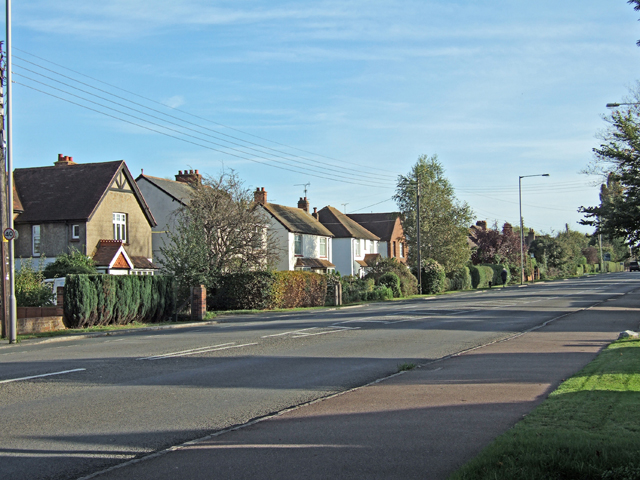
912:== {{int:filedesc}} == {{Information |description={{en|1=The A413 in Stoke Mandeville, going towards Wendover The pavement on the right is shared by cyclists & pedestrians. The houses on the left come just within the Weston Turville boundary.}} |date=200
83:
51:
359:– You must give appropriate credit, provide a link to the license, and indicate if changes were made. You may do so in any reasonable manner, but not in any way that suggests the licensor endorses you or your use.
228:
126:
The A413 in Stoke
Mandeville, going towards Wendover The pavement on the right is shared by cyclists & pedestrians. The houses on the left come just within the Weston Turville boundary.
954:
687:
671:
589:
545:
679:
454:
790:
786:
683:
667:
541:
450:
446:
438:
695:
691:
675:
629:
585:
442:
434:
905:
894:
889:
42:
1034:
592:"}},"text\/plain":{"en":{"P275":"Creative Commons Attribution-ShareAlike 2.0 Generic"}}}}": -->
698:"}},"text\/plain":{"en":{"P973":"https:\/\/www.geograph.org.uk\/photo\/269826"}}}}": -->
964:
721:
615:
571:
238:
741:
276:
1137:
This file contains additional information, probably added from the digital camera or scanner used to create or digitize it.
1104:
1084:
366:
526:
831:
804:
749:
705:
555:
519:
506:
491:
764:
734:
639:
599:
464:
423:
1274:
322:
1140:
If the file has been modified from its original state, some details may not fully reflect the modified file.
365:– If you remix, transform, or build upon the material, you must distribute your contributions under the
283:
on the
Geograph website for the photographer's contact details. The copyright on this image is owned by
1243:
457:"}},"text\/plain":{"en":{"P3831":"photographer"}}}}": -->
548:"}},"text\/plain":{"en":{"P6216":"copyrighted"}}}}": -->
922:
The following pages on the
English Knowledge use this file (pages on other projects are not listed):
797:"}},"text\/plain":{"en":{"P7787":"157 degree"}}}}": -->
1044:
91:
183:
1327:
1094:
771:
756:
498:
319:
167:
8:
1363:
263:
244:
288:
78:
413:
926:
116:
The A413 in Stoke
Mandeville, going towards Wendover - geograph.org.uk - 269826.jpg
52:
The_A413_in_Stoke_Mandeville,_going_towards_Wendover_-_geograph.org.uk_-_269826.jpg
1054:
1431:
1345:
1301:
1166:
1206:
156:
146:
814:
715:
649:
609:
565:
474:
1373:
1159:
268:
974:
1186:
1124:
280:
1449:
1176:
1149:
862:
Click on a date/time to view the file as it appeared at that time.
230:
215:
51° 47′ 39.21″ N, 0° 46′ 56.1″ W
1074:
1024:
1014:
1004:
994:
984:
944:
1064:
135:
66:
407:
Add a one-line explanation of what this file represents
1114:
920:
935:
860:
198:
The A413 in Stoke
Mandeville, going towards Wendover
179:
The A413 in Stoke
Mandeville, going towards Wendover
90:
Commons is a freely licensed media file repository.
616:
Creative
Commons Attribution-ShareAlike 2.0 Generic
590:
Creative
Commons Attribution-ShareAlike 2.0 Generic
56:(640 × 480 pixels, file size: 283 KB, MIME type:
1368:Flash did not fire, compulsory flash suppression
376:https://creativecommons.org/licenses/by-sa/2.0
71:
382:Creative Commons Attribution-Share Alike 2.0
300:
131:
113:
696:https:\/\/www.geograph.org.uk\/photo\/269826
443:https:\/\/www.geograph.org.uk\/profile\/8036
152:
141:
14:
1095:Användare:Lsjbot/Dubletter/Stoke Mandeville
794:
342:– to copy, distribute and transmit the work
937:The following other wikis use this file:
772:https://www.geograph.org.uk/photo/269826
499:https://www.geograph.org.uk/profile/8036
237:View this and other nearby images on:
190:
102:
287:and is licensed for reuse under the
205:
853:
323:Attribution-Share Alike 2.0 Generic
311:
306:
291:Attribution-ShareAlike 2.0 license.
13:
1135:
1121:Usage on zh-min-nan.wikipedia.org
1055:Stoke Mandeville (Buckinghamshire)
412:
406:
297:
274:
120:
103:
49:
1474:
1142:
411:
1197:Date and time of data generation
921:
397:
353:Under the following conditions:
318:This file is licensed under the
310:
305:
299:
267:
243:
229:
221:
70:
31:
21:
394:
121:
46:No higher resolution available.
932:
857:
722:file available on the internet
672:file available on the internet
393:
275:This image was taken from the
26:
1:
820:51°47'39.214"N, 0°46'56.100"W
805:coordinates of depicted place
787:coordinates of depicted place
36:
917:
742:Geograph Britain and Ireland
680:Geograph Britain and Ireland
520:object of statement has role
451:object of statement has role
419:Items portrayed in this file
259:
220:
7:
1399:Focal plane resolution unit
1285:Date and time of digitizing
1132:
1051:Usage on lld.wikipedia.org
971:Usage on ceb.wikipedia.org
961:Usage on arz.wikipedia.org
10:
1479:
1410:One-chip color area sensor
1244:Adobe Photoshop CS Windows
1111:Usage on www.wikidata.org
1101:Usage on uk.wikipedia.org
1091:Usage on sv.wikipedia.org
1081:Usage on ru.wikipedia.org
1071:Usage on no.wikipedia.org
1061:Usage on lt.wikipedia.org
1041:Usage on ko.wikipedia.org
1031:Usage on ja.wikipedia.org
1021:Usage on it.wikipedia.org
1011:Usage on fr.wikipedia.org
1001:Usage on eu.wikipedia.org
991:Usage on es.wikipedia.org
981:Usage on cy.wikipedia.org
975:Stoke Mandeville (lungsod)
951:Usage on ar.wikipedia.org
941:Usage on af.wikipedia.org
367:same or compatible license
110:
105:
1250:File change date and time
955:ستك مندويل (باكينجهامشير)
854:
16:
1391:Focal plane Y resolution
1383:Focal plane X resolution
750:geograph.org.uk image ID
684:geograph.org.uk image ID
396:
333:
77:This is a file from the
41:
1415:Custom image processing
911:
890:16:29, 12 December 2010
168:required by the license
134:
81:. Information from its
1459:Subject distance range
1293:Image compression mode
1288:14:45, 29 October 2006
1253:15:21, 30 October 2006
1200:14:45, 29 October 2006
281:this photograph's page
249:51.794226; -0.782250
84:description page there
1337:Maximum land aperture
1224:Horizontal resolution
1258:Y and C positioning
1232:Vertical resolution
1146:Camera manufacturer
348:– to adapt the work
1441:Scene capture type
1436:Auto white balance
507:author name string
447:author name string
196:sijon /
177:sijon /
1466:
1465:
1171:1/250 sec (0.004)
933:Global file usage
915:
796:
600:copyright license
586:copyright license
405:
296:
295:
279:collection. See
254:
253:
203:
202:
171:
99:
98:
79:Wikimedia Commons
32:Global file usage
1470:
1266:Exposure Program
1143:
1125:Stoke Mandeville
1075:Stoke Mandeville
1025:Stoke Mandeville
1015:Stoke Mandeville
1005:Stoke Mandeville
995:Stoke Mandeville
985:Stoke Mandeville
945:Stoke Mandeville
927:Stoke Mandeville
902:
864:
842:
841:
836:
774:
769:
765:described at URL
759:
754:
744:
739:
692:described at URL
556:copyright status
542:copyright status
529:
524:
514:
511:
501:
496:
403:
389:
386:
383:
380:
377:
369:as the original.
331:
320:Creative Commons
314:
313:
309:
308:
303:
302:
289:Creative Commons
277:Geograph project
271:
264:
250:
247:
233:
232:
226:
225:
224:
218:
217:
206:
165:
137:
125:
117:
111:
95:
74:
73:
67:
61:
59:
1478:
1477:
1473:
1472:
1471:
1469:
1468:
1467:
1340:3 APEX (f/2.83)
1319:APEX brightness
1160:FinePix F10
1131:
1065:Stok Mandevilis
965:ستوكى مانديڤيلى
931:
923:
916:
908:
900:
856:
855:
852:
851:
850:
849:
848:
847:
846:
845:
844:
843:
839:
837:
834:
825:
824:
823:
821:
811:
810:
809:
807:
784:
783:
782:
781:
780:
779:
778:
777:
776:
775:
770:
767:
761:
760:
755:
752:
746:
745:
740:
737:
728:
727:
726:
724:
712:
711:
710:
708:
665:
664:
663:
662:
661:
660:
659:
658:
656:
655:29 October 2006
646:
645:
644:
642:
627:
626:
625:
624:
623:
622:
621:
620:
618:
606:
605:
604:
602:
583:
582:
581:
580:
579:
578:
577:
576:
574:
562:
561:
560:
558:
539:
538:
537:
536:
535:
534:
533:
532:
531:
530:
525:
522:
516:
515:
512:
509:
503:
502:
497:
494:
485:
484:
483:
481:
471:
470:
469:
467:
432:
431:
430:
429:
428:
426:
410:
409:
408:
391:
390:
387:
384:
381:
378:
375:
374:
332:
329:
326:
315:
292:
262:
248:
222:
213:
212:
209:Object location
204:
193:
186:
174:
147:geograph.org.uk
136:29 October 2006
127:
115:
108:
101:
100:
89:
88:
87:is shown below.
63:
57:
55:
48:
47:
12:
11:
5:
1476:
1464:
1463:
1460:
1456:
1455:
1452:
1446:
1445:
1442:
1438:
1437:
1434:
1428:
1427:
1424:
1420:
1419:
1418:Normal process
1416:
1412:
1411:
1408:
1407:Sensing method
1404:
1403:
1400:
1396:
1395:
1392:
1388:
1387:
1384:
1380:
1379:
1376:
1370:
1369:
1366:
1360:
1359:
1356:
1352:
1351:
1348:
1342:
1341:
1338:
1334:
1333:
1330:
1324:
1323:
1320:
1316:
1315:
1312:
1308:
1307:
1304:
1298:
1297:
1294:
1290:
1289:
1286:
1282:
1281:
1278:
1271:
1270:
1269:Normal program
1267:
1263:
1262:
1259:
1255:
1254:
1251:
1247:
1246:
1241:
1237:
1236:
1233:
1229:
1228:
1225:
1221:
1220:
1217:
1213:
1212:
1209:
1202:
1201:
1198:
1194:
1193:
1190:
1183:
1182:
1179:
1173:
1172:
1169:
1163:
1162:
1157:
1153:
1152:
1147:
1134:
1130:
1129:
1128:
1127:
1119:
1118:
1117:
1109:
1108:
1107:
1105:Сток-Мандевілл
1099:
1098:
1097:
1089:
1088:
1087:
1085:Сток-Мандевилл
1079:
1078:
1077:
1069:
1068:
1067:
1059:
1058:
1057:
1049:
1048:
1047:
1039:
1038:
1037:
1029:
1028:
1027:
1019:
1018:
1017:
1009:
1008:
1007:
999:
998:
997:
989:
988:
987:
979:
978:
977:
969:
968:
967:
959:
958:
957:
949:
948:
947:
934:
930:
929:
919:
914:
913:
910:
906:
903:
897:
892:
887:
883:
882:
879:
876:
873:
870:
867:
859:
830:
829:
828:
827:
826:
822:
819:
817:
816:
815:
813:
812:
808:
803:
801:
800:
799:
798:
792:
788:
763:
762:
748:
747:
733:
732:
731:
730:
729:
725:
720:
718:
717:
716:
714:
713:
709:
706:source of file
704:
702:
701:
700:
699:
697:
693:
689:
685:
681:
677:
673:
669:
668:source of file
657:
654:
652:
651:
650:
648:
647:
643:
638:
636:
635:
634:
633:
631:
619:
614:
612:
611:
610:
608:
607:
603:
598:
596:
595:
594:
593:
591:
587:
575:
570:
568:
567:
566:
564:
563:
559:
554:
552:
551:
550:
549:
547:
543:
518:
517:
505:
504:
490:
489:
488:
487:
486:
482:
479:
477:
476:
475:
473:
472:
468:
463:
461:
460:
459:
458:
456:
452:
448:
444:
440:
436:
427:
422:
420:
417:
416:
415:
414:
402:
401:
398:
395:
373:
372:
371:
370:
360:
351:
350:
349:
343:
336:You are free:
327:
317:
316:
298:
294:
293:
272:
261:
258:
252:
251:
241:
235:
210:
201:
200:
194:
191:
188:
187:
182:
175:
172:
160:
159:
154:
150:
149:
143:
139:
138:
133:
129:
128:
118:
109:
107:
104:
97:
96:
75:
65:
64:
45:
40:
39:
34:
29:
24:
19:
9:
6:
4:
3:
2:
1475:
1461:
1458:
1457:
1453:
1451:
1448:
1447:
1443:
1440:
1439:
1435:
1433:
1432:White balance
1430:
1429:
1426:Auto exposure
1425:
1423:Exposure mode
1422:
1421:
1417:
1414:
1413:
1409:
1406:
1405:
1401:
1398:
1397:
1393:
1390:
1389:
1385:
1382:
1381:
1377:
1375:
1372:
1371:
1367:
1365:
1362:
1361:
1357:
1354:
1353:
1349:
1347:
1346:Metering mode
1344:
1343:
1339:
1336:
1335:
1331:
1329:
1328:Exposure bias
1326:
1325:
1321:
1318:
1317:
1313:
1311:APEX aperture
1310:
1309:
1305:
1303:
1302:Shutter speed
1300:
1299:
1295:
1292:
1291:
1287:
1284:
1283:
1279:
1276:
1273:
1272:
1268:
1265:
1264:
1260:
1257:
1256:
1252:
1249:
1248:
1245:
1242:
1240:Software used
1239:
1238:
1234:
1231:
1230:
1226:
1223:
1222:
1218:
1215:
1214:
1210:
1208:
1204:
1203:
1199:
1196:
1195:
1191:
1188:
1185:
1184:
1180:
1178:
1175:
1174:
1170:
1168:
1167:Exposure time
1165:
1164:
1161:
1158:
1155:
1154:
1151:
1148:
1145:
1144:
1141:
1138:
1126:
1123:
1122:
1120:
1116:
1113:
1112:
1110:
1106:
1103:
1102:
1100:
1096:
1093:
1092:
1090:
1086:
1083:
1082:
1080:
1076:
1073:
1072:
1070:
1066:
1063:
1062:
1060:
1056:
1053:
1052:
1050:
1046:
1043:
1042:
1040:
1036:
1033:
1032:
1030:
1026:
1023:
1022:
1020:
1016:
1013:
1012:
1010:
1006:
1003:
1002:
1000:
996:
993:
992:
990:
986:
983:
982:
980:
976:
973:
972:
970:
966:
963:
962:
960:
956:
953:
952:
950:
946:
943:
942:
940:
939:
938:
928:
925:
924:
909:
904:
898:
896:
893:
891:
888:
885:
884:
880:
877:
874:
871:
868:
866:
865:
863:
833:
818:
806:
802:
773:
766:
758:
751:
743:
736:
723:
719:
707:
703:
653:
641:
637:
617:
613:
601:
597:
573:
569:
557:
553:
528:
521:
508:
500:
493:
478:
466:
462:
425:
421:
418:
399:
392:
379:CC BY-SA 2.0
368:
364:
361:
358:
355:
354:
352:
347:
344:
341:
338:
337:
335:
334:
328:Attribution:
324:
321:
304:
290:
286:
282:
278:
273:
270:
266:
265:
257:
256:
246:
242:
240:
239:OpenStreetMap
236:
234:
216:
211:
208:
207:
199:
195:
189:
185:
181: /
180:
176:
169:
164:
162:
161:
158:
155:
151:
148:
144:
140:
130:
124:
119:
112:
93:
86:
85:
80:
76:
69:
68:
62:
53:
44:
38:
35:
33:
30:
28:
25:
23:
20:
18:
15:
1355:Light source
1207:focal length
1156:Camera model
1139:
1136:
936:
861:
858:File history
527:photographer
455:photographer
362:
356:
345:
339:
284:
255:
219:
197:
184:CC BY-SA 2.0
178:
122:
92:You can help
82:
50:
22:File history
1374:Color space
1216:Orientation
1035:ストーク・マンデヴィル
907:GeographBot
572:copyrighted
546:copyrighted
363:share alike
357:attribution
163:Attribution
114:Description
918:File usage
899:640 × 480
875:Dimensions
480:some value
58:image/jpeg
27:File usage
1450:Sharpness
1187:ISO speed
872:Thumbnail
869:Date/Time
640:inception
630:inception
260:Licensing
192:InfoField
173:InfoField
123:English:
1444:Standard
1261:Co-sited
1177:F-number
1150:FUJIFILM
1133:Metadata
1115:Q1027124
901:(283 KB)
735:operator
676:operator
400:Captions
346:to remix
340:to share
325:license.
37:Metadata
1462:Unknown
1358:Unknown
1350:Pattern
1277:version
1211:12.2 mm
886:current
881:Comment
832:heading
791:heading
465:creator
435:creator
424:depicts
404:English
106:Summary
54:
1454:Normal
1235:72 dpi
1227:72 dpi
1219:Normal
1189:rating
1045:스토크맨더빌
840:degree
795:degree
757:269826
688:269826
227:
153:Author
142:Source
1394:3,703
1386:3,703
1364:Flash
1205:Lens
513:sijon
330:sijon
285:sijon
157:sijon
145:From
1378:sRGB
1322:8.09
1306:8.14
1275:Exif
878:User
838:157
388:true
385:true
132:Date
17:File
1314:4.6
1280:2.2
1181:f/5
492:URL
439:URL
1192:80
835::
768::
753::
738::
523::
510::
495::
1402:3
1332:0
1296:4
170:)
166:(
94:.
60:)
_heading:157.00&language=en)
