481:"}},"text\/plain":{"en":{"":"coordinates of the point of view"}}},"{\"value\":{\"latitude\":32.7191030556,\"longitude\":35.5712463889,\"altitude\":null,\"precision\":1.0e-8,\"globe\":\"http:\\\/\\\/www.wikidata.org\\\/entity\\\/Q2\"},\"type\":\"globecoordinate\"}":{"text\/html":{"en":{"P1259":"32\u00b043'8.77102"N, 35\u00b034'16.48700"E"}},"text\/plain":{"en":{"P1259":"32\u00b043'8.77102\"N, 35\u00b034'16.48700\"E"}}},"{\"value\":{\"entity-type\":\"property\",\"numeric-id\":7787,\"id\":\"P7787\"},\"type\":\"wikibase-entityid\"}":{"text\/html":{"en":{"":"
593:"}},"text\/plain":{"en":{"":"inception"}}},"{\"value\":{\"time\":\"+2011-10-01T00:00:00Z\",\"timezone\":0,\"before\":0,\"after\":0,\"precision\":11,\"calendarmodel\":\"http:\\\/\\\/www.wikidata.org\\\/entity\\\/Q1985727\"},\"type\":\"time\"}":{"text\/html":{"en":{"P571":"1 October 2011"}},"text\/plain":{"en":{"P571":"1 October 2011"}}}}": -->
202:
43:
324:
316:
477:
208:
213:
103:
675:"}},"text\/plain":{"en":{"":"ISO speed"}}},"{\"value\":{\"amount\":\"+100\",\"unit\":\"1\"},\"type\":\"quantity\"}":{"text\/html":{"en":{"P6789":"100"}},"text\/plain":{"en":{"P6789":"100"}}}}": -->
758:"}},"text\/plain":{"en":{"":"f-number"}}},"{\"value\":{\"amount\":\"+2.8\",\"unit\":\"1\"},\"type\":\"quantity\"}":{"text\/html":{"en":{"P6790":"2.8"}},"text\/plain":{"en":{"P6790":"2.8"}}}}": -->
713:"}},"text\/plain":{"en":{"":"exposure time"}}},"{\"value\":{\"amount\":\"+0.00125\",\"unit\":\"http:\\\/\\\/www.wikidata.org\\\/entity\\\/Q11574\"},\"type\":\"quantity\"}":{"text\/html":{"en":{"P6757":"0.00125
437:"}},"text\/plain":{"en":{"":"copyright license"}}},"{\"value\":{\"entity-type\":\"item\",\"numeric-id\":14946043,\"id\":\"Q14946043\"},\"type\":\"wikibase-entityid\"}":{"text\/html":{"en":{"P275":"
393:"}},"text\/plain":{"en":{"":"copyright status"}}},"{\"value\":{\"entity-type\":\"item\",\"numeric-id\":50423863,\"id\":\"Q50423863\"},\"type\":\"wikibase-entityid\"}":{"text\/html":{"en":{"P6216":"
631:"}},"text\/plain":{"en":{"":"source of file"}}},"{\"value\":{\"entity-type\":\"item\",\"numeric-id\":66458942,\"id\":\"Q66458942\"},\"type\":\"wikibase-entityid\"}":{"text\/html":{"en":{"P7482":"
549:"}},"text\/plain":{"en":{"":"captured with"}}},"{\"value\":{\"entity-type\":\"item\",\"numeric-id\":63567830,\"id\":\"Q63567830\"},\"type\":\"wikibase-entityid\"}":{"text\/html":{"en":{"P4082":"
796:"}},"text\/plain":{"en":{"":"focal length"}}},"{\"value\":{\"amount\":\"+4.8\",\"unit\":\"http:\\\/\\\/www.wikidata.org\\\/entity\\\/Q174789\"},\"type\":\"quantity\"}":{"text\/html":{"en":{"P2151":"4.8
485:"}},"text\/plain":{"en":{"":"heading"}}},"{\"value\":{\"amount\":\"+111.0\",\"unit\":\"http:\\\/\\\/www.wikidata.org\\\/entity\\\/Q28390\"},\"type\":\"quantity\"}":{"text\/html":{"en":{"P7787":"111.0
792:
260:– You must give appropriate credit, provide a link to the license, and indicate if changes were made. You may do so in any reasonable manner, but not in any way that suggests the licensor endorses you or your use.
321:
307:
632:
550:
438:
394:
793:
755:
710:
672:
628:
546:
482:
478:
390:
590:
434:
441:"}},"text\/plain":{"en":{"P275":"Creative Commons Attribution-ShareAlike 3.0 Unported"}}}}": -->
191:
69:
65:
61:
57:
53:
47:
658:
576:
464:
420:
331:
152:
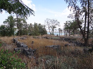
Tel Beth Yerah, "House of the Moon (god)") is a tell located on the southern shore of the Sea of
Galilee in modern day Israel
82:
985:
This file contains additional information, probably added from the digital camera or scanner used to create or digitize it.
267:
114:
807:
765:
724:
682:
642:
560:
523:
496:
404:
635:"}},"text\/plain":{"en":{"P7482":"original creation by uploader"}}}}": -->
600:
448:
379:
1136:
223:
914:
988:
If the file has been modified from its original state, some details may not fully reflect the modified file.
553:"}},"text\/plain":{"en":{"P4082":"Sony DSC-HX100V"}}}}": -->
800:"}},"text\/plain":{"en":{"P2151":"4.8 millimetre"}}}}": -->
717:"}},"text\/plain":{"en":{"P6757":"0.00125 second"}}}}": -->
266:– If you remix, transform, or build upon the material, you must distribute your contributions under the
489:"}},"text\/plain":{"en":{"P7787":"111.0 degree"}}}}": -->
397:"}},"text\/plain":{"en":{"P6216":"copyrighted"}}}}": -->
905:
The following pages on the
English Knowledge use this file (pages on other projects are not listed):
122:
1192:
932:
878:
873:
73:
42:
220:
154:תל בית ירח הוא תל המצוי לחופה הדרומי מערבי של הכנרת בו נמצאים שרידי העיר העתיקה "בית ירח".
8:
1228:
337:
1317:
109:
369:
952:
1288:
1210:
1014:
1327:
1298:
1054:
817:
775:
734:
692:
652:
610:
570:
506:
458:
414:
1246:
909:
1034:
1007:
889:
1337:
1024:
846:
Click on a date/time to view the file as it appeared at that time.
1131:
Landscape mode (for landscape photos with the background in focus)
162:
323:
308:
32° 43′ 08.77″ N, 35° 34′ 16.49″ E
997:
962:
97:
942:
363:
Add a one-line explanation of what this file represents
87:(4,608 × 3,456 pixels, file size: 5.96 MB, MIME type:
972:
903:
923:
844:
465:
Creative
Commons Attribution-ShareAlike 3.0 Unported
439:
Creative
Commons Attribution-ShareAlike 3.0 Unported
121:
Commons is a freely licensed media file repository.
1233:Flash did not fire, compulsory flash suppression
277:https://creativecommons.org/licenses/by-sa/3.0
102:
283:Creative Commons Attribution-Share Alike 3.0
201:
186:
158:
144:
178:
168:
14:
797:
714:
486:
243:– to copy, distribute and transmit the work
925:The following other wikis use this file:
330:View this and other nearby images on:
133:
298:
224:Attribution-Share Alike 3.0 Unported
1395:Reference for direction of movement
837:
212:
207:
13:
983:
368:
362:
198:
134:
80:
1466:
990:
512:32°43'8.77102"N, 35°34'16.48700"E
367:
1411:Reference for direction of image
1045:Date and time of data generation
904:
497:coordinates of the point of view
479:coordinates of the point of view
353:
336:
322:
314:
254:Under the following conditions:
219:This file is licensed under the
211:
206:
200:
101:
31:
21:
350:
920:
841:
349:
26:
1:
1267:A directly photographed image
1083:20,147 meters below sea level
915:User:Ryanmhorne/pleiades List
659:original creation by uploader
633:original creation by uploader
36:
900:
375:Items portrayed in this file
313:
7:
1443:GPS differential correction
1147:Date and time of digitizing
980:
10:
1471:
1238:Supported Flashpix version
969:Usage on www.wikidata.org
959:Usage on id.wikipedia.org
949:Usage on fa.wikipedia.org
939:Usage on es.wikipedia.org
929:Usage on ar.wikipedia.org
268:same or compatible license
141:
136:
1427:Geodetic survey data used
1366:3-dimensional measurement
1155:Meaning of each component
1112:File change date and time
838:
172:
16:
352:
234:
163:1 October 2011, 14:14:26
108:This is a file from the
41:
1358:Measurement in progress
1347:GPS time (atomic clock)
1272:Custom image processing
1008:DSC-HX100V
895:
874:16:05, 20 December 2011
161:
147:Tel Beth Yerah (17).JPG
112:. Information from its
1176:Image compression mode
342:32.719103; 35.571246
115:description page there
46:Size of this preview:
1403:Direction of movement
1387:Speed of GPS receiver
1371:Measurement precision
1202:Maximum land aperture
1150:14:14, 1 October 2011
1115:14:14, 1 October 2011
1096:Horizontal resolution
1048:14:14, 1 October 2011
1259:Digital still camera
74:4,608 × 3,456 pixels
70:2,560 × 1,920 pixels
1382:Kilometers per hour
1120:Y and C positioning
1104:Vertical resolution
1019:1/800 sec (0.00125)
994:Camera manufacturer
249:– to adapt the work
52:Other resolutions:
1419:Direction of image
1414:Magnetic direction
1309:Scene capture type
1293:Auto white balance
66:1,280 × 960 pixels
62:1,024 × 768 pixels
1458:
1457:
921:Global file usage
898:
799:
716:
488:
449:copyright license
435:copyright license
361:
347:
346:
296:
295:
195:
192:Reusing this file
130:
129:
110:Wikimedia Commons
32:Global file usage
1462:
1363:Measurement mode
1128:Exposure Program
1075:35° 34′ 16.49″ E
991:
886:
848:
826:
743:
534:
533:
528:
405:copyright status
391:copyright status
359:
343:
340:
326:
325:
319:
318:
317:
311:
310:
299:
290:
287:
284:
281:
278:
270:as the original.
232:
221:Creative Commons
215:
214:
210:
209:
204:
203:
189:
174:
164:
148:
142:
126:
105:
104:
98:
92:
90:
77:
58:640 × 480 pixels
54:320 × 240 pixels
48:800 × 600 pixels
1470:
1469:
1465:
1464:
1463:
1461:
1460:
1459:
1451:GPS tag version
1355:Receiver status
1205:3 APEX (f/2.83)
1184:APEX brightness
1067:32° 43′ 8.77″ N
979:
919:
906:
899:
892:
884:
840:
839:
836:
835:
834:
833:
832:
831:
830:
829:
827:
824:
814:
813:
812:
810:
791:
790:
789:
788:
787:
786:
785:
784:
782:
772:
771:
770:
768:
753:
752:
751:
750:
749:
748:
747:
746:
744:
741:
731:
730:
729:
727:
708:
707:
706:
705:
704:
703:
702:
701:
699:
689:
688:
687:
685:
670:
669:
668:
667:
666:
665:
664:
663:
661:
649:
648:
647:
645:
626:
625:
624:
623:
622:
621:
620:
619:
617:
607:
606:
605:
603:
588:
587:
586:
585:
584:
583:
582:
581:
579:
577:Sony DSC-HX100V
567:
566:
565:
563:
551:Sony DSC-HX100V
544:
543:
542:
541:
540:
539:
538:
537:
536:
535:
531:
529:
526:
517:
516:
515:
513:
503:
502:
501:
499:
476:
475:
474:
473:
472:
471:
470:
469:
467:
455:
454:
453:
451:
432:
431:
430:
429:
428:
427:
426:
425:
423:
411:
410:
409:
407:
388:
387:
386:
385:
384:
382:
366:
365:
364:
341:
315:
306:
305:
302:Camera location
297:
292:
291:
288:
285:
282:
279:
276:
275:
233:
230:
227:
216:
146:
139:
132:
131:
120:
119:
118:is shown below.
94:
88:
86:
79:
78:
51:
12:
11:
5:
1468:
1456:
1455:
1452:
1448:
1447:
1444:
1440:
1439:
1438:1 October 2011
1436:
1432:
1431:
1428:
1424:
1423:
1420:
1416:
1415:
1412:
1408:
1407:
1404:
1400:
1399:
1398:True direction
1396:
1392:
1391:
1388:
1384:
1383:
1380:
1376:
1375:
1372:
1368:
1367:
1364:
1360:
1359:
1356:
1352:
1351:
1348:
1344:
1343:
1340:
1334:
1333:
1330:
1324:
1323:
1320:
1314:
1313:
1310:
1306:
1305:
1302:
1295:
1294:
1291:
1285:
1284:
1281:
1277:
1276:
1275:Normal process
1273:
1269:
1268:
1265:
1261:
1260:
1257:
1253:
1252:
1249:
1243:
1242:
1239:
1235:
1234:
1231:
1225:
1224:
1221:
1217:
1216:
1213:
1207:
1206:
1203:
1199:
1198:
1195:
1189:
1188:
1185:
1181:
1180:
1177:
1173:
1172:
1171:
1170:
1169:does not exist
1167:
1164:
1161:
1156:
1152:
1151:
1148:
1144:
1143:
1140:
1133:
1132:
1129:
1125:
1124:
1121:
1117:
1116:
1113:
1109:
1108:
1105:
1101:
1100:
1097:
1093:
1092:
1089:
1085:
1084:
1081:
1077:
1076:
1073:
1069:
1068:
1065:
1061:
1060:
1057:
1050:
1049:
1046:
1042:
1041:
1038:
1031:
1030:
1027:
1021:
1020:
1017:
1011:
1010:
1005:
1001:
1000:
995:
982:
978:
977:
976:
975:
967:
966:
965:
957:
956:
955:
947:
946:
945:
937:
936:
935:
922:
918:
917:
912:
902:
897:
896:
894:
890:
887:
883:4,608 × 3,456
881:
876:
871:
867:
866:
863:
860:
857:
854:
851:
843:
828:
822:
820:
819:
818:
816:
815:
811:
806:
804:
803:
802:
801:
795:
783:
780:
778:
777:
776:
774:
773:
769:
764:
762:
761:
760:
759:
757:
745:
739:
737:
736:
735:
733:
732:
728:
723:
721:
720:
719:
718:
712:
700:
697:
695:
694:
693:
691:
690:
686:
681:
679:
678:
677:
676:
674:
662:
657:
655:
654:
653:
651:
650:
646:
643:source of file
641:
639:
638:
637:
636:
634:
630:
629:source of file
618:
616:1 October 2011
615:
613:
612:
611:
609:
608:
604:
599:
597:
596:
595:
594:
592:
580:
575:
573:
572:
571:
569:
568:
564:
559:
557:
556:
555:
554:
552:
548:
522:
521:
520:
519:
518:
514:
511:
509:
508:
507:
505:
504:
500:
495:
493:
492:
491:
490:
484:
480:
468:
463:
461:
460:
459:
457:
456:
452:
447:
445:
444:
443:
442:
440:
436:
424:
419:
417:
416:
415:
413:
412:
408:
403:
401:
400:
399:
398:
396:
392:
383:
378:
376:
373:
372:
371:
370:
358:
357:
354:
351:
345:
344:
334:
328:
303:
294:
293:
274:
273:
272:
271:
261:
252:
251:
250:
244:
237:You are free:
228:
218:
217:
199:
196:
184:
183:
180:
176:
175:
170:
166:
165:
160:
156:
155:
149:
140:
138:
135:
128:
127:
106:
96:
95:
45:
40:
39:
34:
29:
24:
19:
9:
6:
4:
3:
2:
1467:
1453:
1450:
1449:
1445:
1442:
1441:
1437:
1434:
1433:
1429:
1426:
1425:
1421:
1418:
1417:
1413:
1410:
1409:
1405:
1402:
1401:
1397:
1394:
1393:
1389:
1386:
1385:
1381:
1378:
1377:
1374:Poor (1.3185)
1373:
1370:
1369:
1365:
1362:
1361:
1357:
1354:
1353:
1349:
1346:
1345:
1341:
1339:
1336:
1335:
1331:
1329:
1326:
1325:
1321:
1319:
1316:
1315:
1311:
1308:
1307:
1303:
1300:
1297:
1296:
1292:
1290:
1289:White balance
1287:
1286:
1283:Auto exposure
1282:
1280:Exposure mode
1279:
1278:
1274:
1271:
1270:
1266:
1263:
1262:
1258:
1255:
1254:
1250:
1248:
1245:
1244:
1240:
1237:
1236:
1232:
1230:
1227:
1226:
1222:
1219:
1218:
1214:
1212:
1211:Metering mode
1209:
1208:
1204:
1201:
1200:
1196:
1194:
1193:Exposure bias
1191:
1190:
1186:
1183:
1182:
1178:
1175:
1174:
1168:
1165:
1162:
1159:
1158:
1157:
1154:
1153:
1149:
1146:
1145:
1141:
1138:
1135:
1134:
1130:
1127:
1126:
1122:
1119:
1118:
1114:
1111:
1110:
1106:
1103:
1102:
1098:
1095:
1094:
1090:
1087:
1086:
1082:
1079:
1078:
1074:
1071:
1070:
1066:
1063:
1062:
1058:
1056:
1052:
1051:
1047:
1044:
1043:
1039:
1036:
1033:
1032:
1028:
1026:
1023:
1022:
1018:
1016:
1015:Exposure time
1013:
1012:
1009:
1006:
1003:
1002:
999:
996:
993:
992:
989:
986:
974:
971:
970:
968:
964:
963:Ash-Shinnabra
961:
960:
958:
954:
951:
950:
948:
944:
941:
940:
938:
934:
931:
930:
928:
927:
926:
916:
913:
911:
908:
907:
893:
888:
882:
880:
877:
875:
872:
869:
868:
864:
861:
858:
855:
852:
850:
849:
847:
821:
809:
805:
779:
767:
763:
738:
726:
725:exposure time
722:
711:exposure time
696:
684:
680:
660:
656:
644:
640:
614:
602:
598:
578:
574:
562:
561:captured with
558:
547:captured with
525:
510:
498:
494:
466:
462:
450:
446:
422:
418:
406:
402:
381:
377:
374:
355:
348:
339:
335:
333:
332:OpenStreetMap
329:
327:
309:
304:
301:
300:
280:CC BY-SA 3.0
269:
265:
262:
259:
256:
255:
253:
248:
245:
242:
239:
238:
236:
235:
229:Attribution:
225:
222:
205:
197:
193:
188:
185:
181:
177:
171:
167:
157:
153:
150:
143:
124:
117:
116:
111:
107:
100:
99:
93:
84:
83:Original file
75:
71:
67:
63:
59:
55:
49:
44:
38:
35:
33:
30:
28:
25:
23:
20:
18:
15:
1299:Digital zoom
1220:Light source
1055:focal length
1004:Camera model
987:
984:
924:
845:
842:File history
808:focal length
794:focal length
312:
263:
257:
246:
240:
151:
123:You can help
113:
81:
22:File history
1256:File source
1247:Color space
1088:Orientation
943:Al-Sinnabra
910:Al-Sinnabra
421:copyrighted
395:copyrighted
264:share alike
258:attribution
145:Description
1379:Speed unit
1328:Saturation
1264:Scene type
901:File usage
859:Dimensions
825:millimetre
798:millimetre
187:Permission
89:image/jpeg
27:File usage
1338:Sharpness
1312:Landscape
1072:Longitude
1035:ISO speed
885:(5.96 MB)
856:Thumbnail
853:Date/Time
683:ISO speed
673:ISO speed
601:inception
591:inception
1435:GPS date
1318:Contrast
1123:Co-sited
1080:Altitude
1064:Latitude
1025:F-number
981:Metadata
973:Q4703258
933:الصنابرة
766:f-number
756:f-number
740:0.00125
356:Captions
247:to remix
241:to share
226:license.
173:Own work
37:Metadata
1454:0.0.3.2
1223:Unknown
1215:Pattern
1139:version
870:current
865:Comment
524:heading
483:heading
380:depicts
360:English
137:Summary
85:
1430:WGS-84
1406:311.96
1342:Normal
1332:Normal
1322:Normal
1187:8.8375
1107:72 dpi
1099:72 dpi
1091:Normal
1059:4.8 mm
1037:rating
953:صنابره
742:second
715:second
532:degree
530:111.0
487:degree
320:
179:Author
169:Source
1390:0.517
1350:12:14
1301:ratio
1229:Flash
1053:Lens
1029:f/2.8
891:Hanay
231:Hanay
182:Hanay
1251:sRGB
1137:Exif
998:SONY
862:User
823:4.8
289:true
286:true
159:Date
17:File
1422:111
1142:2.3
1040:100
781:2.8
698:100
1166:Cr
1163:Cb
527::
72:|
68:|
64:|
60:|
56:|
50:.
1446:0
1304:1
1241:1
1197:0
1179:3
1160:Y
194:)
190:(
125:.
91:)
76:.

.JPG)
.JPG¶ms=032.719103_N_0035.571246_E_globe:Earth_type:camera_heading:111.00&language=en)