795:"}},"text\/plain":{"en":{"":"coordinates of the point of view"}}},"{\"value\":{\"latitude\":57.832344,\"longitude\":-3.828805,\"altitude\":null,\"precision\":1.0e-6,\"globe\":\"http:\\\/\\\/www.wikidata.org\\\/entity\\\/Q2\"},\"type\":\"globecoordinate\"}":{"text\/html":{"en":{"P1259":"57\u00b049'56.438"N, 3\u00b049'43.698"W"}},"text\/plain":{"en":{"P1259":"57\u00b049'56.438\"N, 3\u00b049'43.698\"W"}}},"{\"value\":{\"entity-type\":\"property\",\"numeric-id\":7787,\"id\":\"P7787\"},\"type\":\"wikibase-entityid\"}":{"text\/html":{"en":{"":"
1036:"}},"text\/plain":{"en":{"":"checksum"}}},"{\"value\":\"1f42ebaf8f3ffc21f37a62a30a824f6e97086341\",\"type\":\"string\"}":{"text\/html":{"en":{"P4092":"1f42ebaf8f3ffc21f37a62a30a824f6e97086341"}},"text\/plain":{"en":{"P4092":"1f42ebaf8f3ffc21f37a62a30a824f6e97086341"}}},"{\"value\":{\"entity-type\":\"property\",\"numeric-id\":459,\"id\":\"P459\"},\"type\":\"wikibase-entityid\"}":{"text\/html":{"en":{"":"
455:"}},"text\/plain":{"en":{"":"author name string"}}},"{\"value\":\"Jim Bain\",\"type\":\"string\"}":{"text\/html":{"en":{"P2093":"Jim Bain"}},"text\/plain":{"en":{"P2093":"Jim Bain"}}},"{\"value\":{\"entity-type\":\"property\",\"numeric-id\":3831,\"id\":\"P3831\"},\"type\":\"wikibase-entityid\"}":{"text\/html":{"en":{"":"
757:"}},"text\/plain":{"en":{"":"inception"}}},"{\"value\":{\"time\":\"+2007-04-01T00:00:00Z\",\"timezone\":0,\"before\":0,\"after\":0,\"precision\":11,\"calendarmodel\":\"http:\\\/\\\/www.wikidata.org\\\/entity\\\/Q1985727\"},\"type\":\"time\"}":{"text\/html":{"en":{"P571":"1 April 2007"}},"text\/plain":{"en":{"P571":"1 April 2007"}}}}": -->
634:
439:
1032:
254:
275:
313:
318:
72:
451:"}},"text\/plain":{"en":{"P2699":"https:\/\/www.geograph.org.uk\/profile\/1825"}}},"{\"value\":{\"entity-type\":\"property\",\"numeric-id\":2093,\"id\":\"P2093\"},\"type\":\"wikibase-entityid\"}":{"text\/html":{"en":{"":"
650:"}},"text\/plain":{"en":{"P973":"https:\/\/www.geograph.org.uk\/photo\/384920"}}},"{\"value\":{\"entity-type\":\"property\",\"numeric-id\":137,\"id\":\"P137\"},\"type\":\"wikibase-entityid\"}":{"text\/html":{"en":{"":"
642:"}},"text\/plain":{"en":{"P7482":"file available on the internet"}}},"{\"value\":{\"entity-type\":\"property\",\"numeric-id\":973,\"id\":\"P973\"},\"type\":\"wikibase-entityid\"}":{"text\/html":{"en":{"":"
658:"}},"text\/plain":{"en":{"P137":"Geograph Britain and Ireland"}}},"{\"value\":{\"entity-type\":\"property\",\"numeric-id\":7384,\"id\":\"P7384\"},\"type\":\"wikibase-entityid\"}":{"text\/html":{"en":{"":"
459:"}},"text\/plain":{"en":{"":"object of statement has role"}}},"{\"value\":{\"entity-type\":\"item\",\"numeric-id\":33231,\"id\":\"Q33231\"},\"type\":\"wikibase-entityid\"}":{"text\/html":{"en":{"P3831":"
1040:"}},"text\/plain":{"en":{"":"determination method"}}},"{\"value\":{\"entity-type\":\"item\",\"numeric-id\":13414952,\"id\":\"Q13414952\"},\"type\":\"wikibase-entityid\"}":{"text\/html":{"en":{"P459":"
863:"}},"text\/plain":{"en":{"":"media type"}}},"{\"value\":\"image\\\/jpeg\",\"type\":\"string\"}":{"text\/html":{"en":{"P1163":"image\/jpeg"}},"text\/plain":{"en":{"P1163":"image\/jpeg"}}}}": -->
594:"}},"text\/plain":{"en":{"":"copyright license"}}},"{\"value\":{\"entity-type\":\"item\",\"numeric-id\":19068220,\"id\":\"Q19068220\"},\"type\":\"wikibase-entityid\"}":{"text\/html":{"en":{"P275":"
550:"}},"text\/plain":{"en":{"":"copyright status"}}},"{\"value\":{\"entity-type\":\"item\",\"numeric-id\":50423863,\"id\":\"Q50423863\"},\"type\":\"wikibase-entityid\"}":{"text\/html":{"en":{"P6216":"
638:"}},"text\/plain":{"en":{"":"source of file"}}},"{\"value\":{\"entity-type\":\"item\",\"numeric-id\":74228490,\"id\":\"Q74228490\"},\"type\":\"wikibase-entityid\"}":{"text\/html":{"en":{"P7482":"
901:"}},"text\/plain":{"en":{"":"data size"}}},"{\"value\":{\"amount\":\"+76519\",\"unit\":\"http:\\\/\\\/www.wikidata.org\\\/entity\\\/Q8799\"},\"type\":\"quantity\"}":{"text\/html":{"en":{"P3575":"76,519
946:"}},"text\/plain":{"en":{"":"height"}}},"{\"value\":{\"amount\":\"+423\",\"unit\":\"http:\\\/\\\/www.wikidata.org\\\/entity\\\/Q355198\"},\"type\":\"quantity\"}":{"text\/html":{"en":{"P2048":"423
654:"}},"text\/plain":{"en":{"":"operator"}}},"{\"value\":{\"entity-type\":\"item\",\"numeric-id\":1503119,\"id\":\"Q1503119\"},\"type\":\"wikibase-entityid\"}":{"text\/html":{"en":{"P137":"
991:"}},"text\/plain":{"en":{"":"width"}}},"{\"value\":{\"amount\":\"+640\",\"unit\":\"http:\\\/\\\/www.wikidata.org\\\/entity\\\/Q355198\"},\"type\":\"quantity\"}":{"text\/html":{"en":{"P2049":"640
799:"}},"text\/plain":{"en":{"":"heading"}}},"{\"value\":{\"amount\":\"+0\",\"unit\":\"http:\\\/\\\/www.wikidata.org\\\/entity\\\/Q28390\"},\"type\":\"quantity\"}":{"text\/html":{"en":{"P7787":"0
443:"}},"text\/plain":{"en":{"":"creator"}}},"{\"value\":{\"entity-type\":\"property\",\"numeric-id\":2699,\"id\":\"P2699\"},\"type\":\"wikibase-entityid\"}":{"text\/html":{"en":{"":"
987:
662:"}},"text\/plain":{"en":{"":"geograph.org.uk image ID"}}},"{\"value\":\"384920\",\"type\":\"string\"}":{"text\/html":{"en":{"P7384":"
1197:
43:
365:– You must give appropriate credit, provide a link to the license, and indicate if changes were made. You may do so in any reasonable manner, but not in any way that suggests the licensor endorses you or your use.
237:
223:
1041:
663:
639:
595:
551:
655:
460:
1033:
988:
943:
898:
860:
796:
792:
659:
635:
547:
456:
452:
444:
1037:
754:
651:
647:
643:
591:
448:
440:
1158:== Summary == {{Information |Description=Old Tarbat Parish Church |Source=From |Date=2007-04-01 |Author= |Permission=Creative Commons Attribution S
598:"}},"text\/plain":{"en":{"P275":"Creative Commons Attribution-ShareAlike 2.0 Generic"}}}}": -->
1177:
160:
1085:
689:
621:
577:
247:
724:
282:
1238:
This file contains additional information, probably added from the digital camera or scanner used to create or digitize it.
372:
532:
1051:
1002:
957:
912:
870:
837:
810:
732:
673:
561:
525:
512:
497:
1192:
83:
1078:
764:
717:
702:
605:
470:
429:
51:
1182:
328:
1241:
If the file has been modified from its original state, some details may not fully reflect the modified file.
371:– If you remix, transform, or build upon the material, you must distribute your contributions under the
289:
on the
Geograph website for the photographer's contact details. The copyright on this image is owned by
463:"}},"text\/plain":{"en":{"P3831":"photographer"}}}}": -->
905:"}},"text\/plain":{"en":{"P3575":"76,519 byte"}}}}": -->
554:"}},"text\/plain":{"en":{"P6216":"copyrighted"}}}}": -->
1168:
The following pages on the
English Knowledge use this file (pages on other projects are not listed):
995:"}},"text\/plain":{"en":{"P2049":"640 pixel"}}}}": -->
950:"}},"text\/plain":{"en":{"P2048":"423 pixel"}}}}": -->
803:"}},"text\/plain":{"en":{"P7787":"0 degree"}}}}": -->
91:
666:"}},"text\/plain":{"en":{"P7384":"384920"}}}}": -->
192:
1044:"}},"text\/plain":{"en":{"P459":"SHA-1"}}}}": -->
739:
709:
504:
325:
176:
8:
269:
1140:
1135:
253:
42:
1198:
Knowledge:WikiProject
Historic sites/Images of listed buildings in Scotland without ID
294:
78:
419:
1172:
1151:
1187:
149:
139:
1061:
1012:
967:
922:
880:
820:
774:
683:
615:
571:
480:
274:
286:
1108:
Click on a date/time to view the file as it appeared at that time.
239:
224:
57° 49′ 56.44″ N, 3° 49′ 43.7″ W
1215:
128:
66:
413:
Add a one-line explanation of what this file represents
1225:
1166:
1206:
1106:
167:
Creative
Commons Attribution Share-alike license 2.0
90:
Commons is a freely licensed media file repository.
622:
Creative
Commons Attribution-ShareAlike 2.0 Generic
596:
Creative
Commons Attribution-ShareAlike 2.0 Generic
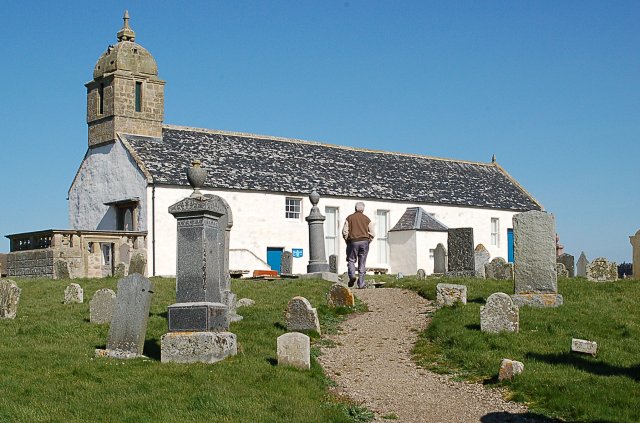
120:Old Tarbat Parish Church, Portmahomack, Scotland
56:(640 × 423 pixels, file size: 75 KB, MIME type:
382:https://creativecommons.org/licenses/by-sa/2.0
71:
388:Creative Commons Attribution-Share Alike 2.0
306:
155:
124:
113:
1178:List of listed buildings in Tarbat, Highland
648:https:\/\/www.geograph.org.uk\/photo\/384920
449:https:\/\/www.geograph.org.uk\/profile\/1825
145:
134:
14:
992:
947:
902:
800:
348:– to copy, distribute and transmit the work
1208:The following other wikis use this file:
1067:1f42ebaf8f3ffc21f37a62a30a824f6e97086341
710:https://www.geograph.org.uk/photo/384920
505:https://www.geograph.org.uk/profile/1825
246:View this and other nearby images on:
199:
102:
293:and is licensed for reuse under the
214:
1099:
329:Attribution-Share Alike 2.0 Generic
317:
312:
297:Attribution-ShareAlike 2.0 license.
13:
1236:
1193:User:MauraWen/sandbox Portmahomack
418:
412:
303:
280:
103:
49:
1262:
1243:
417:
1167:
811:coordinates of the point of view
793:coordinates of the point of view
403:
359:Under the following conditions:
324:This file is licensed under the
316:
311:
305:
273:
252:
238:
230:
70:
31:
21:
1183:List of wars involving Scotland
400:
46:No higher resolution available.
1203:
1103:
690:file available on the internet
640:file available on the internet
399:
281:This image was taken from the
26:
1:
826:57°49'56.438"N, 3°49'43.698"W
36:
1163:
725:Geograph Britain and Ireland
656:Geograph Britain and Ireland
526:object of statement has role
457:object of statement has role
425:Items portrayed in this file
265:
7:
1233:
10:
1267:
1222:Usage on www.wikidata.org
1212:Usage on it.wikipedia.org
373:same or compatible license
229:
110:
105:
1100:
16:
733:geograph.org.uk image ID
660:geograph.org.uk image ID
402:
339:
207:Old Tarbat Parish Church
188:Old Tarbat Parish Church
77:This is a file from the
41:
1157:
177:required by the license
127:
81:. Information from its
287:this photograph's page
258:57.832344; -3.828805
84:description page there
205:Jim Bain /
186:Jim Bain /
116:Tarbat Old Church.jpg
52:Tarbat_Old_Church.jpg
1136:10:14, 17 April 2009
1079:determination method
1038:determination method
354:– to adapt the work
513:author name string
453:author name string
1254:
1253:
1204:Global file usage
1161:
994:
949:
904:
802:
606:copyright license
592:copyright license
411:
302:
301:
285:collection. See
263:
262:
212:
211:
180:
164:
161:Reusing this file
99:
98:
79:Wikimedia Commons
32:Global file usage
1258:
1244:
1173:Battle of Tarbat
1148:
1110:
1088:
1083:
1021:
976:
931:
848:
847:
842:
742:
737:
727:
722:
712:
707:
703:described at URL
644:described at URL
562:copyright status
548:copyright status
535:
530:
520:
517:
507:
502:
409:
395:
392:
389:
386:
383:
375:as the original.
337:
326:Creative Commons
320:
319:
315:
314:
309:
308:
295:Creative Commons
283:Geograph project
277:
270:
259:
256:
242:
241:
235:
234:
233:
227:
226:
215:
174:
158:
130:
117:
111:
95:
74:
73:
67:
61:
59:
1266:
1265:
1261:
1260:
1259:
1257:
1256:
1255:
1232:
1202:
1169:
1162:
1154:
1146:
1102:
1101:
1098:
1097:
1096:
1095:
1094:
1093:
1092:
1091:
1090:
1089:
1084:
1081:
1072:
1071:
1070:
1068:
1058:
1057:
1056:
1054:
1031:
1030:
1029:
1028:
1027:
1026:
1025:
1024:
1022:
1019:
1009:
1008:
1007:
1005:
986:
985:
984:
983:
982:
981:
980:
979:
977:
974:
964:
963:
962:
960:
941:
940:
939:
938:
937:
936:
935:
934:
932:
929:
919:
918:
917:
915:
896:
895:
894:
893:
892:
891:
890:
889:
887:
877:
876:
875:
873:
858:
857:
856:
855:
854:
853:
852:
851:
850:
849:
845:
843:
840:
831:
830:
829:
827:
817:
816:
815:
813:
790:
789:
788:
787:
786:
785:
784:
783:
781:
771:
770:
769:
767:
752:
751:
750:
749:
748:
747:
746:
745:
744:
743:
738:
735:
729:
728:
723:
720:
714:
713:
708:
705:
696:
695:
694:
692:
680:
679:
678:
676:
633:
632:
631:
630:
629:
628:
627:
626:
624:
612:
611:
610:
608:
589:
588:
587:
586:
585:
584:
583:
582:
580:
568:
567:
566:
564:
545:
544:
543:
542:
541:
540:
539:
538:
537:
536:
531:
528:
522:
521:
518:
515:
509:
508:
503:
500:
491:
490:
489:
487:
477:
476:
475:
473:
438:
437:
436:
435:
434:
432:
416:
415:
414:
397:
396:
393:
390:
387:
384:
381:
380:
338:
335:
332:
321:
298:
268:
257:
231:
222:
221:
218:Camera location
213:
202:
195:
183:
140:geograph.org.uk
115:
108:
101:
100:
89:
88:
87:is shown below.
63:
57:
55:
48:
47:
12:
11:
5:
1264:
1252:
1251:
1248:
1235:
1231:
1230:
1229:
1228:
1220:
1219:
1218:
1205:
1201:
1200:
1195:
1190:
1185:
1180:
1175:
1165:
1160:
1159:
1156:
1152:
1149:
1143:
1138:
1133:
1129:
1128:
1125:
1122:
1119:
1116:
1113:
1105:
1077:
1076:
1075:
1074:
1073:
1069:
1066:
1064:
1063:
1062:
1060:
1059:
1055:
1050:
1048:
1047:
1046:
1045:
1043:
1039:
1035:
1023:
1017:
1015:
1014:
1013:
1011:
1010:
1006:
1001:
999:
998:
997:
996:
990:
978:
972:
970:
969:
968:
966:
965:
961:
956:
954:
953:
952:
951:
945:
933:
927:
925:
924:
923:
921:
920:
916:
911:
909:
908:
907:
906:
900:
888:
885:
883:
882:
881:
879:
878:
874:
869:
867:
866:
865:
864:
862:
836:
835:
834:
833:
832:
828:
825:
823:
822:
821:
819:
818:
814:
809:
807:
806:
805:
804:
798:
794:
782:
779:
777:
776:
775:
773:
772:
768:
763:
761:
760:
759:
758:
756:
731:
730:
716:
715:
701:
700:
699:
698:
697:
693:
688:
686:
685:
684:
682:
681:
677:
674:source of file
672:
670:
669:
668:
667:
665:
661:
657:
653:
649:
645:
641:
637:
636:source of file
625:
620:
618:
617:
616:
614:
613:
609:
604:
602:
601:
600:
599:
597:
593:
581:
576:
574:
573:
572:
570:
569:
565:
560:
558:
557:
556:
555:
553:
549:
524:
523:
511:
510:
496:
495:
494:
493:
492:
488:
485:
483:
482:
481:
479:
478:
474:
469:
467:
466:
465:
464:
462:
458:
454:
450:
446:
442:
433:
428:
426:
423:
422:
421:
420:
408:
407:
404:
401:
379:
378:
377:
376:
366:
357:
356:
355:
349:
342:You are free:
333:
323:
322:
304:
300:
299:
278:
267:
264:
261:
260:
250:
244:
219:
210:
209:
203:
200:
197:
196:
191:
184:
181:
169:
168:
165:
153:
152:
147:
143:
142:
136:
132:
131:
126:
122:
121:
118:
109:
107:
104:
97:
96:
75:
65:
64:
45:
40:
39:
34:
29:
24:
19:
9:
6:
4:
3:
2:
1263:
1249:
1246:
1245:
1242:
1239:
1227:
1224:
1223:
1221:
1217:
1214:
1213:
1211:
1210:
1209:
1199:
1196:
1194:
1191:
1189:
1186:
1184:
1181:
1179:
1176:
1174:
1171:
1170:
1155:
1150:
1144:
1142:
1139:
1137:
1134:
1131:
1130:
1126:
1123:
1120:
1117:
1114:
1112:
1111:
1109:
1087:
1080:
1065:
1053:
1049:
1016:
1004:
1000:
971:
959:
955:
926:
914:
910:
884:
872:
868:
839:
824:
812:
808:
778:
766:
762:
741:
734:
726:
719:
711:
704:
691:
687:
675:
671:
623:
619:
607:
603:
579:
575:
563:
559:
534:
527:
514:
506:
499:
484:
472:
468:
431:
427:
424:
405:
398:
385:CC BY-SA 2.0
374:
370:
367:
364:
361:
360:
358:
353:
350:
347:
344:
343:
341:
340:
334:Attribution:
330:
327:
310:
296:
292:
288:
284:
279:
276:
272:
271:
255:
251:
249:
248:OpenStreetMap
245:
243:
225:
220:
217:
216:
208:
204:
198:
194:
190: /
189:
185:
178:
173:
171:
170:
166:
162:
157:
154:
151:
148:
144:
141:
137:
133:
123:
119:
112:
93:
86:
85:
80:
76:
69:
68:
62:
53:
44:
38:
35:
33:
30:
28:
25:
23:
20:
18:
15:
1240:
1237:
1216:Portmahomack
1207:
1188:Portmahomack
1107:
1104:File history
780:1 April 2007
533:photographer
461:photographer
368:
362:
351:
345:
290:
228:
206:
193:CC BY-SA 2.0
187:
129:1 April 2007
92:You can help
82:
50:
22:File history
578:copyrighted
552:copyrighted
369:share alike
363:attribution
172:Attribution
114:Description
1247:_error
1164:File usage
1145:640 × 423
1121:Dimensions
886:image/jpeg
871:media type
861:media type
486:some value
156:Permission
58:image/jpeg
27:File usage
1153:Le Deluge
1118:Thumbnail
1115:Date/Time
913:data size
899:data size
765:inception
755:inception
266:Licensing
201:InfoField
182:InfoField
1234:Metadata
1226:Q4872508
1052:checksum
1034:checksum
718:operator
652:operator
519:Jim Bain
406:Captions
352:to remix
346:to share
336:Jim Bain
331:license.
291:Jim Bain
150:Jim Bain
37:Metadata
1147:(75 KB)
1132:current
1127:Comment
928:76,519
838:heading
797:heading
471:creator
441:creator
430:depicts
410:English
106:Summary
54:
958:height
944:height
846:degree
801:degree
740:384920
664:384920
236:
146:Author
135:Source
1086:SHA-1
1042:SHA-1
1020:pixel
1003:width
993:pixel
989:width
975:pixel
948:pixel
138:From
1124:User
1018:640
973:423
930:byte
903:byte
394:true
391:true
125:Date
17:File
498:URL
445:URL
1082::
844:0
841::
736::
721::
706::
529::
516::
501::
1250:0
179:)
175:(
163:)
159:(
94:.
60:)
