413:"}},"text\/plain":{"en":{"":"inception"}}},"{\"value\":{\"time\":\"+2020-11-21T00:00:00Z\",\"timezone\":0,\"before\":0,\"after\":0,\"precision\":11,\"calendarmodel\":\"http:\\\/\\\/www.wikidata.org\\\/entity\\\/Q1985727\"},\"type\":\"time\"}":{"text\/html":{"en":{"P571":"21 November 2020"}},"text\/plain":{"en":{"P571":"21 November 2020"}}}}": -->
195:
43:
201:
206:
99:
369:"}},"text\/plain":{"en":{"":"copyright license"}}},"{\"value\":{\"entity-type\":\"item\",\"numeric-id\":14946043,\"id\":\"Q14946043\"},\"type\":\"wikibase-entityid\"}":{"text\/html":{"en":{"P275":"
325:"}},"text\/plain":{"en":{"":"copyright status"}}},"{\"value\":{\"entity-type\":\"item\",\"numeric-id\":50423863,\"id\":\"Q50423863\"},\"type\":\"wikibase-entityid\"}":{"text\/html":{"en":{"P6216":"
321:
489:
247:– You must give appropriate credit, provide a link to the license, and indicate if changes were made. You may do so in any reasonable manner, but not in any way that suggests the licensor endorses you or your use.
370:
326:
322:
410:
366:
675:
600:
785:
373:"}},"text\/plain":{"en":{"P275":"Creative Commons Attribution-ShareAlike 3.0 Unported"}}}}": -->
833:
1092:
396:
352:
888:
878:
853:
1103:
This file contains additional information, probably added from the digital camera or scanner used to create or digitize it.
73:
69:
65:
536:
Uploaded a work by Own work based on User:NordNordWest from
Derivative of File:Sudan adm location map.svg with UploadWizard
254:
61:
57:
53:
47:
336:
805:
770:
828:
420:
380:
311:
110:
82:
883:
873:
730:
800:
518:
513:
216:
1106:
If the file has been modified from its original state, some details may not fully reflect the modified file.
655:
780:
760:
253:– If you remix, transform, or build upon the material, you must distribute your contributions under the
790:
858:
795:
329:"}},"text\/plain":{"en":{"P6216":"copyrighted"}}}}": -->
868:
848:
546:
The following pages on the
English Knowledge use this file (pages on other projects are not listed):
680:
153:
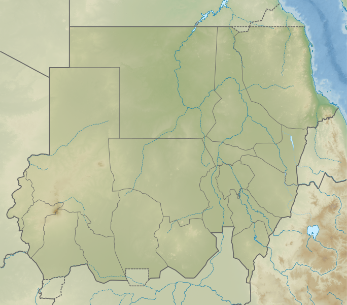
Relief map of Sudan. Elevation data from STRM30, bathymetry from GMRT, rivers/coastline from GSHHG.
740:
118:
595:
1078:
838:
690:
565:
1053:
580:
213:
715:
8:
775:
725:
700:
665:
863:
488:
483:
42:
898:
745:
650:
560:
105:
625:
301:
750:
685:
605:
575:
843:
823:
938:
765:
720:
998:
660:
550:
943:
755:
670:
645:
630:
615:
585:
430:
390:
346:
1048:
973:
983:
735:
695:
640:
635:
610:
988:
968:
555:
529:
499:
1018:
978:
1038:
590:
456:
Click on a date/time to view the file as it appeared at that time.
993:
1003:
87:(SVG file, nominally 1,654 × 1,450 pixels, file size: 2.09 MB)
620:
570:
1033:
1028:
1043:
1013:
963:
913:
710:
705:
1023:
1008:
162:
93:
958:
1073:
953:
544:
908:
814:
454:
397:
Creative
Commons Attribution-ShareAlike 3.0 Unported
371:
Creative
Commons Attribution-ShareAlike 3.0 Unported
117:
Commons is a freely licensed media file repository.
933:
923:
1083:
1068:
1063:
928:
918:
676:List of fossiliferous stratigraphic units in Sudan
948:
506:Fixed incorrectly-colored Eritrea-Ethiopia border
601:Gaafar Ibnauf Children's Emergency Hospital
1054:Sudana Universitato por Scienco kaj Teknologio
786:User:CarrotsandCelery/Ghaba Neolithic Cemetery
264:https://creativecommons.org/licenses/by-sa/3.0
98:
270:Creative Commons Attribution-Share Alike 3.0
194:
172:Derivative of File:Sudan adm location map.svg
158:
140:
176:
168:
14:
230:– to copy, distribute and transmit the work
46:Size of this PNG preview of this SVG file:
816:The following other wikis use this file:
899:Knowledge:Kartenwerkstatt/Archiv/2022-03
1079:Plantilla:Mapa de localización de Sudán
129:
217:Attribution-Share Alike 3.0 Unported
447:
205:
200:
180:Own work based on User:NordNordWest
13:
1101:
806:Module:Location map/data/Sudan/doc
771:Upper Atbara and Setit Dam Complex
300:
294:
191:
147:
130:
80:
1135:
1108:
299:
545:
285:
241:Under the following conditions:
212:This file is licensed under the
204:
199:
193:
97:
31:
21:
731:Relief of Gebel Sheikh Suleiman
282:
148:
811:
801:Module:Location map/data/Sudan
451:
281:
26:
1:
939:Ŝablono:Situo sur mapo Sudano
36:
999:Okcidenta Darfuro (subŝtato)
656:Kadero (archaeological site)
541:
307:Items portrayed in this file
187:
7:
1098:
781:User:CarrotsandCelery/Ghaba
761:Temple of Mut, Jebel Barkal
10:
1140:
1060:Usage on es.wikipedia.org
905:Usage on eo.wikipedia.org
895:Usage on de.wikipedia.org
820:Usage on bg.wikipedia.org
791:User:Firecracker28/sandbox
255:same or compatible license
137:
132:
796:User:PotteryCrumb/sandbox
448:
16:
681:List of monarchs of Kush
284:
221:
104:This is a file from the
41:
1049:Universitato de Ĥartumo
741:Second Battle of Heglig
535:
514:04:21, 22 November 2020
505:
484:04:23, 22 November 2020
161:
108:. Information from its
984:Blanka Nilo (subŝtato)
596:First Battle of Heglig
111:description page there
691:Meidob volcanic field
566:Bayuda volcanic field
989:Blua Nilo (subŝtato)
969:Al Gezira (subŝtato)
944:Ruĝa Maro (subŝtato)
581:Dinder National Park
143:Sudan relief map.svg
74:1,654 × 1,450 pixels
70:2,336 × 2,048 pixels
66:1,168 × 1,024 pixels
1004:Okcidenta Kurdufano
776:Wadi Milk Formation
726:Radom National Park
701:Musawwarat es-Sufra
666:Khashm el-Girba Dam
295:Relief map of Sudan
236:– to adapt the work
52:Other resolutions:
1019:Kassala (subŝtato)
979:Gedaref (subŝtato)
974:Ĥartumo (subŝtato)
626:Gulf of 'Agig
1127:
1126:
1093:more global usage
1039:Sennar (subŝtato)
812:Global file usage
746:Sedeinga pyramids
716:Pyramids of Meroë
651:Jebel Umm Arafieb
561:Battle of Geneina
539:
381:copyright license
367:copyright license
293:
184:
183:
126:
125:
106:Wikimedia Commons
32:Global file usage
1131:
1109:
994:Norda (subŝtato)
889:Кордофан (плато)
879:Байюда (пустиня)
834:Нубийска пустиня
751:Shendi Formation
686:Marrah Mountains
606:Gabal El Uweinat
576:Deriba (caldera)
526:
496:
458:
436:21 November 2020
337:copyright status
323:copyright status
291:
277:
274:
271:
268:
265:
257:as the original.
214:Creative Commons
208:
207:
203:
202:
197:
196:
164:
163:21 November 2020
152:
144:
138:
122:
101:
100:
94:
88:
77:
62:876 × 768 pixels
58:548 × 480 pixels
54:274 × 240 pixels
48:684 × 600 pixels
1139:
1138:
1134:
1133:
1132:
1130:
1129:
1128:
1097:
1034:Orienta Darfuro
1029:Norda Kurdufano
854:Шаблон:ПК Судан
810:
547:
540:
532:
524:
502:
494:
450:
449:
446:
445:
444:
443:
442:
441:
440:
439:
437:
427:
426:
425:
423:
408:
407:
406:
405:
404:
403:
402:
401:
399:
387:
386:
385:
383:
364:
363:
362:
361:
360:
359:
358:
357:
355:
343:
342:
341:
339:
320:
319:
318:
317:
316:
314:
298:
297:
296:
279:
278:
275:
272:
269:
266:
263:
262:
220:
209:
190:
185:
154:
142:
135:
128:
127:
116:
115:
114:is shown below.
90:
86:
79:
78:
51:
12:
11:
5:
1137:
1125:
1124:
1121:
1117:
1116:
1113:
1100:
1095:of this file.
1089:
1088:
1087:
1086:
1081:
1076:
1071:
1066:
1058:
1057:
1056:
1051:
1046:
1044:Centra Darfuro
1041:
1036:
1031:
1026:
1021:
1016:
1014:Suda Kurdufano
1011:
1006:
1001:
996:
991:
986:
981:
976:
971:
966:
961:
956:
951:
946:
941:
936:
931:
926:
921:
916:
914:Bajuda-Dezerto
911:
903:
902:
901:
893:
892:
891:
886:
884:Дарфур (плато)
881:
876:
874:Гедареф (град)
871:
866:
861:
856:
851:
846:
841:
836:
831:
826:
813:
809:
808:
803:
798:
793:
788:
783:
778:
773:
768:
766:Tombos (Nubia)
763:
758:
753:
748:
743:
738:
733:
728:
723:
721:R12 (cemetery)
718:
713:
708:
703:
698:
693:
688:
683:
678:
673:
668:
663:
658:
653:
648:
643:
638:
633:
628:
623:
618:
613:
608:
603:
598:
593:
588:
583:
578:
573:
568:
563:
558:
553:
543:
538:
537:
534:
530:
527:
523:1,654 × 1,450
521:
516:
511:
508:
507:
504:
500:
497:
493:1,654 × 1,450
491:
486:
481:
477:
476:
473:
470:
467:
464:
461:
453:
438:
435:
433:
432:
431:
429:
428:
424:
419:
417:
416:
415:
414:
412:
400:
395:
393:
392:
391:
389:
388:
384:
379:
377:
376:
375:
374:
372:
368:
356:
351:
349:
348:
347:
345:
344:
340:
335:
333:
332:
331:
330:
328:
324:
315:
310:
308:
305:
304:
303:
302:
290:
289:
286:
283:
261:
260:
259:
258:
248:
239:
238:
237:
231:
224:You are free:
211:
210:
192:
189:
186:
182:
181:
178:
174:
173:
170:
166:
165:
160:
156:
155:
145:
136:
134:
131:
124:
123:
102:
92:
91:
45:
40:
39:
34:
29:
24:
19:
9:
6:
4:
3:
2:
1136:
1122:
1119:
1118:
1114:
1111:
1110:
1107:
1104:
1096:
1094:
1085:
1082:
1080:
1077:
1075:
1072:
1070:
1067:
1065:
1062:
1061:
1059:
1055:
1052:
1050:
1047:
1045:
1042:
1040:
1037:
1035:
1032:
1030:
1027:
1025:
1024:Norda Darfuro
1022:
1020:
1017:
1015:
1012:
1010:
1007:
1005:
1002:
1000:
997:
995:
992:
990:
987:
985:
982:
980:
977:
975:
972:
970:
967:
965:
962:
960:
957:
955:
952:
950:
947:
945:
942:
940:
937:
935:
932:
930:
927:
925:
922:
920:
917:
915:
912:
910:
907:
906:
904:
900:
897:
896:
894:
890:
887:
885:
882:
880:
877:
875:
872:
870:
867:
865:
862:
860:
857:
855:
852:
850:
847:
845:
842:
840:
837:
835:
832:
830:
829:Джебел Баркал
827:
825:
822:
821:
819:
818:
817:
807:
804:
802:
799:
797:
794:
792:
789:
787:
784:
782:
779:
777:
774:
772:
769:
767:
764:
762:
759:
757:
754:
752:
749:
747:
744:
742:
739:
737:
734:
732:
729:
727:
724:
722:
719:
717:
714:
712:
709:
707:
704:
702:
699:
697:
694:
692:
689:
687:
684:
682:
679:
677:
674:
672:
669:
667:
664:
662:
661:Karima, Sudan
659:
657:
654:
652:
649:
647:
644:
642:
639:
637:
634:
632:
629:
627:
624:
622:
619:
617:
614:
612:
609:
607:
604:
602:
599:
597:
594:
592:
589:
587:
584:
582:
579:
577:
574:
572:
569:
567:
564:
562:
559:
557:
554:
552:
551:Agok Skirmish
549:
548:
533:
528:
522:
520:
517:
515:
512:
510:
509:
503:
498:
492:
490:
487:
485:
482:
479:
478:
474:
471:
468:
465:
462:
460:
459:
457:
434:
422:
418:
398:
394:
382:
378:
354:
350:
338:
334:
313:
309:
306:
287:
280:
267:CC BY-SA 3.0
256:
252:
249:
246:
243:
242:
240:
235:
232:
229:
226:
225:
223:
222:
218:
215:
198:
179:
175:
171:
167:
157:
151:
146:
139:
120:
113:
112:
107:
103:
96:
95:
89:
84:
83:Original file
75:
71:
67:
63:
59:
55:
49:
44:
38:
35:
33:
30:
28:
25:
23:
20:
18:
15:
1105:
1102:
1090:
1009:Suda Darfuro
859:Абией (град)
815:
756:Tagabo Hills
671:Lake Ptolemy
646:Jebel Sahaba
631:Jebel Barkal
616:Gebel al-Ain
586:Dungonab Bay
455:
452:File history
250:
244:
233:
227:
149:
119:You can help
109:
81:
22:File history
353:copyrighted
327:copyrighted
251:share alike
245:attribution
141:Description
1123:1450.109px
1115:1653.539px
869:Ад-Дамазин
849:Порт Судан
736:Sabu-Jaddi
696:Merowe Dam
641:Jebel Moya
636:Jebel Dair
611:Gabal Elba
542:File usage
469:Dimensions
27:File usage
964:Bir Taŭil
959:Kurdufano
556:Al-Khiday
525:(2.09 MB)
495:(2.09 MB)
466:Thumbnail
463:Date/Time
421:inception
411:inception
188:Licensing
150:English:
1099:Metadata
1074:Mirgissa
954:El-Kurru
839:Омдурман
591:El-Kurru
288:Captions
234:to remix
228:to share
219:license.
37:Metadata
909:Darfuro
864:Кадукли
480:current
475:Comment
312:depicts
292:English
133:Summary
85:
1120:Height
934:Tungul
924:Napata
844:Абидия
824:Хартум
177:Author
169:Source
1112:Width
1091:View
1084:Aksha
1069:Buhen
1064:Kerma
929:Meroe
919:Nubio
621:Ghaba
571:Buhen
949:Nuri
711:Nuri
706:Naqa
531:C1MM
501:C1MM
472:User
276:true
273:true
159:Date
17:File
72:|
68:|
64:|
60:|
56:|
50:.
121:.
76:.

