784:"}},"text\/plain":{"en":{"":"coordinates of depicted place"}}},"{\"value\":{\"latitude\":53.0632,\"longitude\":-3.202,\"altitude\":null,\"precision\":0.0001,\"globe\":\"http:\\\/\\\/www.wikidata.org\\\/entity\\\/Q2\"},\"type\":\"globecoordinate\"}":{"text\/html":{"en":{"P9149":"53\u00b03'47.5"N, 3\u00b012'7.2"W"}},"text\/plain":{"en":{"P9149":"53\u00b03'47.5\"N, 3\u00b012'7.2\"W"}}}}": -->
746:"}},"text\/plain":{"en":{"":"inception"}}},"{\"value\":{\"time\":\"+2006-02-25T00:00:00Z\",\"timezone\":0,\"before\":0,\"after\":0,\"precision\":11,\"calendarmodel\":\"http:\\\/\\\/www.wikidata.org\\\/entity\\\/Q1985727\"},\"type\":\"time\"}":{"text\/html":{"en":{"P571":"25 February 2006"}},"text\/plain":{"en":{"P571":"25 February 2006"}}}}": -->
623:
428:
240:
264:
302:
307:
72:
950:"}},"text\/plain":{"en":{"":"ISO speed"}}},"{\"value\":{\"amount\":\"+100\",\"unit\":\"1\"},\"type\":\"quantity\"}":{"text\/html":{"en":{"P6789":"100"}},"text\/plain":{"en":{"P6789":"100"}}}}": -->
867:"}},"text\/plain":{"en":{"":"f-number"}}},"{\"value\":{\"amount\":\"+4.5\",\"unit\":\"1\"},\"type\":\"quantity\"}":{"text\/html":{"en":{"P6790":"4.5"}},"text\/plain":{"en":{"P6790":"4.5"}}}}": -->
440:"}},"text\/plain":{"en":{"P2699":"https:\/\/www.geograph.org.uk\/profile\/4582"}}},"{\"value\":{\"entity-type\":\"property\",\"numeric-id\":3831,\"id\":\"P3831\"},\"type\":\"wikibase-entityid\"}":{"text\/html":{"en":{"":"
639:"}},"text\/plain":{"en":{"P973":"https:\/\/www.geograph.org.uk\/photo\/127765"}}},"{\"value\":{\"entity-type\":\"property\",\"numeric-id\":137,\"id\":\"P137\"},\"type\":\"wikibase-entityid\"}":{"text\/html":{"en":{"":"
452:"}},"text\/plain":{"en":{"":"author name string"}}},"{\"value\":\"Eirian Evans\",\"type\":\"string\"}":{"text\/html":{"en":{"P2093":"Eirian Evans"}},"text\/plain":{"en":{"P2093":"Eirian Evans"}}}}": -->
631:"}},"text\/plain":{"en":{"P7482":"file available on the internet"}}},"{\"value\":{\"entity-type\":\"property\",\"numeric-id\":973,\"id\":\"P973\"},\"type\":\"wikibase-entityid\"}":{"text\/html":{"en":{"":"
647:"}},"text\/plain":{"en":{"P137":"Geograph Britain and Ireland"}}},"{\"value\":{\"entity-type\":\"property\",\"numeric-id\":7384,\"id\":\"P7384\"},\"type\":\"wikibase-entityid\"}":{"text\/html":{"en":{"":"
444:"}},"text\/plain":{"en":{"":"object of statement has role"}}},"{\"value\":{\"entity-type\":\"item\",\"numeric-id\":33231,\"id\":\"Q33231\"},\"type\":\"wikibase-entityid\"}":{"text\/html":{"en":{"P3831":"
822:"}},"text\/plain":{"en":{"":"exposure time"}}},"{\"value\":{\"amount\":\"+0.00125\",\"unit\":\"http:\\\/\\\/www.wikidata.org\\\/entity\\\/Q11574\"},\"type\":\"quantity\"}":{"text\/html":{"en":{"P6757":"0.00125
988:"}},"text\/plain":{"en":{"":"media type"}}},"{\"value\":\"image\\\/jpeg\",\"type\":\"string\"}":{"text\/html":{"en":{"P1163":"image\/jpeg"}},"text\/plain":{"en":{"P1163":"image\/jpeg"}}}}": -->
583:"}},"text\/plain":{"en":{"":"copyright license"}}},"{\"value\":{\"entity-type\":\"item\",\"numeric-id\":19068220,\"id\":\"Q19068220\"},\"type\":\"wikibase-entityid\"}":{"text\/html":{"en":{"P275":"
539:"}},"text\/plain":{"en":{"":"copyright status"}}},"{\"value\":{\"entity-type\":\"item\",\"numeric-id\":50423863,\"id\":\"Q50423863\"},\"type\":\"wikibase-entityid\"}":{"text\/html":{"en":{"P6216":"
627:"}},"text\/plain":{"en":{"":"source of file"}}},"{\"value\":{\"entity-type\":\"item\",\"numeric-id\":74228490,\"id\":\"Q74228490\"},\"type\":\"wikibase-entityid\"}":{"text\/html":{"en":{"P7482":"
905:"}},"text\/plain":{"en":{"":"focal length"}}},"{\"value\":{\"amount\":\"+6.8\",\"unit\":\"http:\\\/\\\/www.wikidata.org\\\/entity\\\/Q174789\"},\"type\":\"quantity\"}":{"text\/html":{"en":{"P2151":"6.8
448:"}},"text\/plain":{"en":{"P3831":"photographer"}}},"{\"value\":{\"entity-type\":\"property\",\"numeric-id\":2093,\"id\":\"P2093\"},\"type\":\"wikibase-entityid\"}":{"text\/html":{"en":{"":"
1026:"}},"text\/plain":{"en":{"":"instance of"}}},"{\"value\":{\"entity-type\":\"item\",\"numeric-id\":125191,\"id\":\"Q125191\"},\"type\":\"wikibase-entityid\"}":{"text\/html":{"en":{"P31":"
643:"}},"text\/plain":{"en":{"":"operator"}}},"{\"value\":{\"entity-type\":\"item\",\"numeric-id\":1503119,\"id\":\"Q1503119\"},\"type\":\"wikibase-entityid\"}":{"text\/html":{"en":{"P137":"
432:"}},"text\/plain":{"en":{"":"creator"}}},"{\"value\":{\"entity-type\":\"property\",\"numeric-id\":2699,\"id\":\"P2699\"},\"type\":\"wikibase-entityid\"}":{"text\/html":{"en":{"":"
1108:
984:
651:"}},"text\/plain":{"en":{"":"geograph.org.uk image ID"}}},"{\"value\":\"127765\",\"type\":\"string\"}":{"text\/html":{"en":{"P7384":"
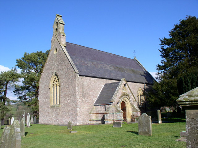
1125:== {{int:filedesc}} == {{Information |description={{en|1=St Tegla's Church. Rebuilt in 1866 on an early medieval foundation. http://www.cpat.demon.co.uk/projects/longer/churches/denbigh/16828.htm}} |date=2006-02-25 |source=From [http://www.geograph.org.uk
217:
354:– You must give appropriate credit, provide a link to the license, and indicate if changes were made. You may do so in any reasonable manner, but not in any way that suggests the licensor endorses you or your use.
223:
83:
51:
652:
628:
584:
540:
644:
1027:
445:
985:
947:
902:
864:
819:
781:
648:
624:
536:
449:
441:
433:
743:
640:
636:
632:
580:
437:
429:
1023:
1118:
1270:
587:"}},"text\/plain":{"en":{"P275":"Creative Commons Attribution-ShareAlike 2.0 Generic"}}}}": -->
1354:
678:
610:
566:
233:
713:
271:
1240:
This file contains additional information, probably added from the digital camera or scanner used to create or digitize it.
1053:
361:
508:
995:
957:
916:
874:
833:
791:
721:
662:
550:
516:
501:
486:
753:
706:
691:
594:
459:
418:
1107:
1102:
1037:
42:
1385:
317:
1243:
If the file has been modified from its original state, some details may not fully reflect the modified file.
1207:
127:
909:"}},"text\/plain":{"en":{"P2151":"6.8 millimetre"}}}}": -->
826:"}},"text\/plain":{"en":{"P6757":"0.00125 second"}}}}": -->
360:– If you remix, transform, or build upon the material, you must distribute your contributions under the
278:
on the
Geograph website for the photographer's contact details. The copyright on this image is owned by
543:"}},"text\/plain":{"en":{"P6216":"copyrighted"}}}}": -->
1135:
The following pages on the
English Knowledge use this file (pages on other projects are not listed):
1030:"}},"text\/plain":{"en":{"P31":"photograph"}}}}": -->
1260:
91:
655:"}},"text\/plain":{"en":{"P7384":"127765"}}}}": -->
186:
1412:
728:
698:
493:
314:
170:
8:
1448:
258:
239:
1513:
283:
78:
408:
1484:
1430:
1277:
1523:
1494:
1317:
159:
149:
1458:
1047:
1005:
967:
926:
884:
843:
801:
763:
672:
604:
560:
469:
263:
1297:
128:
http://www.cpat.demon.co.uk/projects/longer/churches/denbigh/16828.htm
1139:
275:
126:
St Tegla's Church. Rebuilt in 1866 on an early medieval foundation.
1533:
1287:
1177:
1075:
Click on a date/time to view the file as it appeared at that time.
225:
218:
53° 03′ 48″ N, 3° 12′ 07″ W
138:
66:
1208:
Utente:BohemianRhapsody/Lista delle comunità del Galles
402:
Add a one-line explanation of what this file represents
1227:
1217:
1197:
1187:
1167:
1157:
1133:
1148:
1073:
90:
Commons is a freely licensed media file repository.
52:
St_Tegla's_Church_-_geograph.org.uk_-_127765.jpg
611:
Creative
Commons Attribution-ShareAlike 2.0 Generic
585:
Creative
Commons Attribution-ShareAlike 2.0 Generic
116:St Tegla's Church - geograph.org.uk - 127765.jpg
56:(640 × 479 pixels, file size: 97 KB, MIME type:
1380:Creative program (biased toward depth of field)
371:https://creativecommons.org/licenses/by-sa/2.0
71:
377:Creative Commons Attribution-Share Alike 2.0
295:
134:
113:
637:https:\/\/www.geograph.org.uk\/photo\/127765
438:https:\/\/www.geograph.org.uk\/profile\/4582
155:
144:
14:
906:
823:
337:– to copy, distribute and transmit the work
1150:The following other wikis use this file:
699:https://www.geograph.org.uk/photo/127765
494:https://www.geograph.org.uk/profile/4582
232:View this and other nearby images on:
193:
102:
282:and is licensed for reuse under the
208:
1066:
318:Attribution-Share Alike 2.0 Generic
306:
301:
286:Attribution-ShareAlike 2.0 license.
13:
1238:
407:
401:
292:
269:
120:
103:
49:
1550:
1245:
406:
1308:Date and time of data generation
1134:
392:
348:Under the following conditions:
313:This file is licensed under the
305:
300:
294:
262:
238:
224:
70:
31:
21:
1252:OLYMPUS DIGITAL CAMERA
389:
121:
46:No higher resolution available.
1145:
1070:
679:file available on the internet
629:file available on the internet
388:
270:This image was taken from the
26:
1:
1453:Flash did not fire, auto mode
792:coordinates of depicted place
782:coordinates of depicted place
36:
1130:
714:Geograph Britain and Ireland
645:Geograph Britain and Ireland
502:object of statement has role
442:object of statement has role
414:Items portrayed in this file
254:
7:
1396:Date and time of digitizing
1235:
10:
1555:
1224:Usage on sv.wikipedia.org
1214:Usage on kw.wikipedia.org
1204:Usage on it.wikipedia.org
1194:Usage on gd.wikipedia.org
1184:Usage on es.wikipedia.org
1174:Usage on de.wikipedia.org
1164:Usage on cy.wikipedia.org
1154:Usage on br.wikipedia.org
362:same or compatible license
110:
105:
1361:File change date and time
1067:
199:Eirian Evans /
180:Eirian Evans /
16:
722:geograph.org.uk image ID
649:geograph.org.uk image ID
391:
328:
77:This is a file from the
41:
1468:Custom image processing
1399:13:36, 25 February 2006
1364:13:36, 25 February 2006
1311:13:36, 25 February 2006
1261:OLYMPUS OPTICAL CO.,LTD
1124:
807:53°3'47.5"N, 3°12'7.2"W
171:required by the license
137:
81:. Information from its
1404:Image compression mode
1178:Tegla von Denbighshire
1103:04:52, 31 January 2010
276:this photograph's page
244:53.063200; -3.202000
84:description page there
1422:Maximum land aperture
1335:Horizontal resolution
1369:Y and C positioning
1343:Vertical resolution
1282:1/800 sec (0.00125)
1257:Camera manufacturer
343:– to adapt the work
1505:Scene capture type
1489:Auto white balance
517:author name string
450:author name string
1542:
1541:
1146:Global file usage
1128:
908:
825:
595:copyright license
581:copyright license
400:
291:
290:
274:collection. See
249:
248:
206:
205:
201:St Tegla's Church
182:St Tegla's Church
174:
99:
98:
79:Wikimedia Commons
32:Global file usage
1546:
1377:Exposure Program
1246:
1115:
1077:
935:
852:
769:25 February 2006
731:
726:
716:
711:
701:
696:
692:described at URL
633:described at URL
551:copyright status
537:copyright status
524:
521:
511:
506:
496:
491:
398:
384:
381:
378:
375:
372:
364:as the original.
326:
315:Creative Commons
309:
308:
304:
303:
298:
297:
284:Creative Commons
272:Geograph project
266:
259:
245:
242:
228:
227:
221:
220:
209:
168:
140:
139:25 February 2006
125:
117:
111:
95:
74:
73:
67:
61:
59:
1554:
1553:
1549:
1548:
1547:
1545:
1544:
1543:
1425:3 APEX (f/2.83)
1234:
1144:
1136:
1129:
1121:
1113:
1069:
1068:
1065:
1064:
1063:
1062:
1061:
1060:
1059:
1058:
1056:
1044:
1043:
1042:
1040:
1021:
1020:
1019:
1018:
1017:
1016:
1015:
1014:
1012:
1002:
1001:
1000:
998:
983:
982:
981:
980:
979:
978:
977:
976:
974:
964:
963:
962:
960:
945:
944:
943:
942:
941:
940:
939:
938:
936:
933:
923:
922:
921:
919:
900:
899:
898:
897:
896:
895:
894:
893:
891:
881:
880:
879:
877:
862:
861:
860:
859:
858:
857:
856:
855:
853:
850:
840:
839:
838:
836:
817:
816:
815:
814:
813:
812:
811:
810:
808:
798:
797:
796:
794:
779:
778:
777:
776:
775:
774:
773:
772:
770:
760:
759:
758:
756:
741:
740:
739:
738:
737:
736:
735:
734:
733:
732:
727:
724:
718:
717:
712:
709:
703:
702:
697:
694:
685:
684:
683:
681:
669:
668:
667:
665:
622:
621:
620:
619:
618:
617:
616:
615:
613:
601:
600:
599:
597:
578:
577:
576:
575:
574:
573:
572:
571:
569:
557:
556:
555:
553:
534:
533:
532:
531:
530:
529:
528:
527:
526:
525:
522:
519:
513:
512:
507:
504:
498:
497:
492:
489:
480:
479:
478:
476:
466:
465:
464:
462:
427:
426:
425:
424:
423:
421:
405:
404:
403:
386:
385:
382:
379:
376:
373:
370:
369:
327:
324:
321:
310:
287:
257:
243:
216:
215:
212:Object location
207:
196:
189:
177:
150:geograph.org.uk
130:
115:
108:
101:
100:
89:
88:
87:is shown below.
63:
57:
55:
48:
47:
12:
11:
5:
1552:
1540:
1539:
1536:
1530:
1529:
1526:
1520:
1519:
1516:
1510:
1509:
1506:
1502:
1501:
1498:
1491:
1490:
1487:
1481:
1480:
1477:
1473:
1472:
1471:Normal process
1469:
1465:
1464:
1461:
1455:
1454:
1451:
1445:
1444:
1441:
1437:
1436:
1433:
1427:
1426:
1423:
1419:
1418:
1415:
1409:
1408:
1405:
1401:
1400:
1397:
1393:
1392:
1389:
1382:
1381:
1378:
1374:
1373:
1370:
1366:
1365:
1362:
1358:
1357:
1352:
1348:
1347:
1344:
1340:
1339:
1336:
1332:
1331:
1328:
1324:
1323:
1320:
1313:
1312:
1309:
1305:
1304:
1301:
1294:
1293:
1290:
1284:
1283:
1280:
1274:
1273:
1268:
1264:
1263:
1258:
1254:
1253:
1250:
1237:
1233:
1232:
1231:
1230:
1222:
1221:
1220:
1212:
1211:
1210:
1202:
1201:
1200:
1192:
1191:
1190:
1182:
1181:
1180:
1172:
1171:
1170:
1162:
1161:
1160:
1147:
1143:
1142:
1132:
1127:
1126:
1123:
1119:
1116:
1110:
1105:
1100:
1096:
1095:
1092:
1089:
1086:
1083:
1080:
1072:
1057:
1052:
1050:
1049:
1048:
1046:
1045:
1041:
1036:
1034:
1033:
1032:
1031:
1029:
1025:
1013:
1010:
1008:
1007:
1006:
1004:
1003:
999:
994:
992:
991:
990:
989:
987:
975:
972:
970:
969:
968:
966:
965:
961:
956:
954:
953:
952:
951:
949:
937:
931:
929:
928:
927:
925:
924:
920:
915:
913:
912:
911:
910:
904:
892:
889:
887:
886:
885:
883:
882:
878:
873:
871:
870:
869:
868:
866:
854:
848:
846:
845:
844:
842:
841:
837:
832:
830:
829:
828:
827:
821:
809:
806:
804:
803:
802:
800:
799:
795:
790:
788:
787:
786:
785:
783:
771:
768:
766:
765:
764:
762:
761:
757:
752:
750:
749:
748:
747:
745:
720:
719:
705:
704:
690:
689:
688:
687:
686:
682:
677:
675:
674:
673:
671:
670:
666:
663:source of file
661:
659:
658:
657:
656:
654:
650:
646:
642:
638:
634:
630:
626:
625:source of file
614:
609:
607:
606:
605:
603:
602:
598:
593:
591:
590:
589:
588:
586:
582:
570:
565:
563:
562:
561:
559:
558:
554:
549:
547:
546:
545:
544:
542:
538:
515:
514:
500:
499:
485:
484:
483:
482:
481:
477:
474:
472:
471:
470:
468:
467:
463:
458:
456:
455:
454:
453:
451:
447:
443:
439:
435:
431:
422:
417:
415:
412:
411:
410:
409:
397:
396:
393:
390:
368:
367:
366:
365:
355:
346:
345:
344:
338:
331:You are free:
322:
312:
311:
293:
289:
288:
267:
256:
253:
247:
246:
236:
230:
213:
204:
203:
197:
194:
191:
190:
185:
178:
175:
163:
162:
157:
153:
152:
146:
142:
141:
136:
132:
131:
118:
109:
107:
104:
97:
96:
75:
65:
64:
45:
40:
39:
34:
29:
24:
19:
9:
6:
4:
3:
2:
1551:
1537:
1535:
1532:
1531:
1527:
1525:
1522:
1521:
1517:
1515:
1512:
1511:
1507:
1504:
1503:
1499:
1496:
1493:
1492:
1488:
1486:
1485:White balance
1483:
1482:
1479:Auto exposure
1478:
1476:Exposure mode
1475:
1474:
1470:
1467:
1466:
1462:
1460:
1457:
1456:
1452:
1450:
1447:
1446:
1442:
1439:
1438:
1434:
1432:
1431:Metering mode
1429:
1428:
1424:
1421:
1420:
1416:
1414:
1413:Exposure bias
1411:
1410:
1406:
1403:
1402:
1398:
1395:
1394:
1390:
1387:
1384:
1383:
1379:
1376:
1375:
1371:
1368:
1367:
1363:
1360:
1359:
1356:
1353:
1351:Software used
1350:
1349:
1345:
1342:
1341:
1337:
1334:
1333:
1329:
1326:
1325:
1321:
1319:
1315:
1314:
1310:
1307:
1306:
1302:
1299:
1296:
1295:
1291:
1289:
1286:
1285:
1281:
1279:
1278:Exposure time
1276:
1275:
1272:
1271:C4100Z,C4000Z
1269:
1266:
1265:
1262:
1259:
1256:
1255:
1251:
1248:
1247:
1244:
1241:
1229:
1226:
1225:
1223:
1219:
1216:
1215:
1213:
1209:
1206:
1205:
1203:
1199:
1196:
1195:
1193:
1189:
1186:
1185:
1183:
1179:
1176:
1175:
1173:
1169:
1166:
1165:
1163:
1159:
1156:
1155:
1153:
1152:
1151:
1141:
1138:
1137:
1122:
1117:
1111:
1109:
1106:
1104:
1101:
1098:
1097:
1093:
1090:
1087:
1084:
1081:
1079:
1078:
1076:
1055:
1051:
1039:
1035:
1009:
997:
993:
971:
959:
955:
930:
918:
914:
888:
876:
872:
847:
835:
834:exposure time
831:
820:exposure time
805:
793:
789:
767:
755:
751:
730:
723:
715:
708:
700:
693:
680:
676:
664:
660:
612:
608:
596:
592:
568:
564:
552:
548:
518:
510:
503:
495:
488:
473:
461:
457:
420:
416:
413:
394:
387:
374:CC BY-SA 2.0
363:
359:
356:
353:
350:
349:
347:
342:
339:
336:
333:
332:
330:
329:
323:Attribution:
319:
316:
299:
285:
281:
277:
273:
268:
265:
261:
260:
252:
251:
241:
237:
235:
234:OpenStreetMap
231:
229:
219:
214:
211:
210:
202:
198:
192:
188:
184: /
183:
179:
172:
167:
165:
164:
161:
158:
154:
151:
147:
143:
133:
129:
124:
119:
112:
93:
86:
85:
80:
76:
69:
68:
62:
53:
44:
38:
35:
33:
30:
28:
25:
23:
20:
18:
15:
1495:Digital zoom
1440:Light source
1318:focal length
1267:Camera model
1242:
1239:
1149:
1074:
1071:File history
917:focal length
903:focal length
523:Eirian Evans
509:photographer
446:photographer
357:
351:
340:
334:
325:Eirian Evans
280:Eirian Evans
279:
250:
200:
187:CC BY-SA 2.0
181:
160:Eirian Evans
122:
92:You can help
82:
50:
22:File history
1459:Color space
1327:Orientation
1249:Image title
1120:GeographBot
1038:instance of
1024:instance of
567:copyrighted
541:copyrighted
358:share alike
352:attribution
166:Attribution
114:Description
1524:Saturation
1131:File usage
1112:640 × 479
1088:Dimensions
1054:photograph
1028:photograph
1011:image/jpeg
996:media type
986:media type
934:millimetre
907:millimetre
475:some value
58:image/jpeg
27:File usage
1534:Sharpness
1508:Landscape
1298:ISO speed
1228:Llandegla
1218:Llandegla
1198:Llandegla
1188:Llandegla
1168:Llandegla
1158:Llandegla
1140:Llandegla
1085:Thumbnail
1082:Date/Time
958:ISO speed
948:ISO speed
754:inception
744:inception
255:Licensing
195:InfoField
176:InfoField
123:English:
1514:Contrast
1372:Co-sited
1355:v575u-77
1288:F-number
1236:Metadata
875:f-number
865:f-number
849:0.00125
707:operator
641:operator
395:Captions
341:to remix
335:to share
320:license.
37:Metadata
1443:Unknown
1435:Pattern
1388:version
1114:(97 KB)
1099:current
1094:Comment
460:creator
430:creator
419:depicts
399:English
106:Summary
54:
1538:Normal
1528:Normal
1518:Normal
1346:72 dpi
1338:72 dpi
1330:Normal
1322:6.8 mm
1300:rating
851:second
824:second
729:127765
653:127765
222:
156:Author
145:Source
1497:ratio
1449:Flash
1316:Lens
1292:f/4.5
148:From
1463:sRGB
1386:Exif
1091:User
932:6.8
383:true
380:true
135:Date
17:File
1391:2.2
1303:100
973:100
890:4.5
487:URL
434:URL
725::
710::
695::
520::
505::
490::
1500:0
1417:0
1407:2
173:)
169:(
94:.
60:)
_&language=en)
