786:"}},"text\/plain":{"en":{"":"coordinates of the point of view"}}},"{\"value\":{\"latitude\":53.16851,\"longitude\":-3.144321,\"altitude\":null,\"precision\":1.0e-6,\"globe\":\"http:\\\/\\\/www.wikidata.org\\\/entity\\\/Q2\"},\"type\":\"globecoordinate\"}":{"text\/html":{"en":{"P1259":"53\u00b010'6.636"N, 3\u00b08'39.556"W"}},"text\/plain":{"en":{"P1259":"53\u00b010'6.636\"N, 3\u00b08'39.556\"W"}}},"{\"value\":{\"entity-type\":\"property\",\"numeric-id\":7787,\"id\":\"P7787\"},\"type\":\"wikibase-entityid\"}":{"text\/html":{"en":{"":"
446:"}},"text\/plain":{"en":{"":"author name string"}}},"{\"value\":\"Aaron Thomas\",\"type\":\"string\"}":{"text\/html":{"en":{"P2093":"Aaron Thomas"}},"text\/plain":{"en":{"P2093":"Aaron Thomas"}}},"{\"value\":{\"entity-type\":\"property\",\"numeric-id\":3831,\"id\":\"P3831\"},\"type\":\"wikibase-entityid\"}":{"text\/html":{"en":{"":"
629:"}},"text\/plain":{"en":{"":"inception"}}},"{\"value\":{\"time\":\"+2006-12-02T00:00:00Z\",\"timezone\":0,\"before\":0,\"after\":0,\"precision\":11,\"calendarmodel\":\"http:\\\/\\\/www.wikidata.org\\\/entity\\\/Q1985727\"},\"type\":\"time\"}":{"text\/html":{"en":{"P571":"2 December 2006"}},"text\/plain":{"en":{"P571":"2 December 2006"}}}}": -->
663:
430:
782:
245:
266:
304:
309:
72:
442:"}},"text\/plain":{"en":{"P2699":"https:\/\/www.geograph.org.uk\/profile\/8220"}}},"{\"value\":{\"entity-type\":\"property\",\"numeric-id\":2093,\"id\":\"P2093\"},\"type\":\"wikibase-entityid\"}":{"text\/html":{"en":{"":"
671:"}},"text\/plain":{"en":{"P7482":"file available on the internet"}}},"{\"value\":{\"entity-type\":\"property\",\"numeric-id\":137,\"id\":\"P137\"},\"type\":\"wikibase-entityid\"}":{"text\/html":{"en":{"":"
679:"}},"text\/plain":{"en":{"P137":"Geograph Britain and Ireland"}}},"{\"value\":{\"entity-type\":\"property\",\"numeric-id\":7384,\"id\":\"P7384\"},\"type\":\"wikibase-entityid\"}":{"text\/html":{"en":{"":"
450:"}},"text\/plain":{"en":{"":"object of statement has role"}}},"{\"value\":{\"entity-type\":\"item\",\"numeric-id\":33231,\"id\":\"Q33231\"},\"type\":\"wikibase-entityid\"}":{"text\/html":{"en":{"P3831":"
585:"}},"text\/plain":{"en":{"":"copyright license"}}},"{\"value\":{\"entity-type\":\"item\",\"numeric-id\":19068220,\"id\":\"Q19068220\"},\"type\":\"wikibase-entityid\"}":{"text\/html":{"en":{"P275":"
541:"}},"text\/plain":{"en":{"":"copyright status"}}},"{\"value\":{\"entity-type\":\"item\",\"numeric-id\":50423863,\"id\":\"Q50423863\"},\"type\":\"wikibase-entityid\"}":{"text\/html":{"en":{"P6216":"
667:"}},"text\/plain":{"en":{"":"source of file"}}},"{\"value\":{\"entity-type\":\"item\",\"numeric-id\":74228490,\"id\":\"Q74228490\"},\"type\":\"wikibase-entityid\"}":{"text\/html":{"en":{"P7482":"
675:"}},"text\/plain":{"en":{"":"operator"}}},"{\"value\":{\"entity-type\":\"item\",\"numeric-id\":1503119,\"id\":\"Q1503119\"},\"type\":\"wikibase-entityid\"}":{"text\/html":{"en":{"P137":"
790:"}},"text\/plain":{"en":{"":"heading"}}},"{\"value\":{\"amount\":\"+45\",\"unit\":\"http:\\\/\\\/www.wikidata.org\\\/entity\\\/Q28390\"},\"type\":\"quantity\"}":{"text\/html":{"en":{"P7787":"45
687:"}},"text\/plain":{"en":{"P7384":"298867"}}},"{\"value\":{\"entity-type\":\"property\",\"numeric-id\":973,\"id\":\"P973\"},\"type\":\"wikibase-entityid\"}":{"text\/html":{"en":{"":"
434:"}},"text\/plain":{"en":{"":"creator"}}},"{\"value\":{\"entity-type\":\"property\",\"numeric-id\":2699,\"id\":\"P2699\"},\"type\":\"wikibase-entityid\"}":{"text\/html":{"en":{"":"
537:
691:"}},"text\/plain":{"en":{"":"described at URL"}}},"{\"value\":\"https:\\\/\\\/www.geograph.org.uk\\\/photo\\\/298867\",\"type\":\"string\"}":{"text\/html":{"en":{"P973":"
438:"}},"text\/plain":{"en":{"":"URL"}}},"{\"value\":\"https:\\\/\\\/www.geograph.org.uk\\\/profile\\\/8220\",\"type\":\"string\"}":{"text\/html":{"en":{"P2699":"
909:{{Information |Description={{en|1=Photograph of St Mary's Church, Mold, from the south}} |Source=http://www.geograph.org.uk/photo/298867 |Author=Aaron Thomas |Date=2006-12-02 |Permission= |other_versions= }} {{geograph}} <!--{{ImageUpload|full}}--> [[Cate
683:"}},"text\/plain":{"en":{"":"geograph.org.uk image ID"}}},"{\"value\":\"298867\",\"type\":\"string\"}":{"text\/html":{"en":{"P7384":"
43:
356:– You must give appropriate credit, provide a link to the license, and indicate if changes were made. You may do so in any reasonable manner, but not in any way that suggests the licensor endorses you or your use.
228:
214:
928:
684:
668:
586:
542:
676:
451:
787:
783:
680:
664:
538:
447:
443:
435:
692:
688:
672:
626:
582:
439:
431:
589:"}},"text\/plain":{"en":{"P275":"Creative Commons Attribution-ShareAlike 2.0 Generic"}}}}": -->
958:
83:
51:
695:"}},"text\/plain":{"en":{"P973":"https:\/\/www.geograph.org.uk\/photo\/298867"}}}}": -->
953:
718:
612:
568:
238:
738:
273:
989:
This file contains additional information, probably added from the digital camera or scanner used to create or digitize it.
938:
363:
523:
828:
801:
746:
702:
552:
516:
503:
488:
948:
761:
731:
636:
596:
461:
420:
1116:
319:
992:
If the file has been modified from its original state, some details may not fully reflect the modified file.
943:
362:– If you remix, transform, or build upon the material, you must distribute your contributions under the
280:
on the
Geograph website for the photographer's contact details. The copyright on this image is owned by
933:
454:"}},"text\/plain":{"en":{"P3831":"photographer"}}}}": -->
923:
545:"}},"text\/plain":{"en":{"P6216":"copyrighted"}}}}": -->
919:
The following pages on the
English Knowledge use this file (pages on other projects are not listed):
794:"}},"text\/plain":{"en":{"P7787":"45 degree"}}}}": -->
91:
891:
886:
183:
42:
1143:
768:
753:
495:
316:
167:
8:
1179:
902:
260:
244:
1233:
285:
78:
410:
1215:
1161:
1018:
1243:
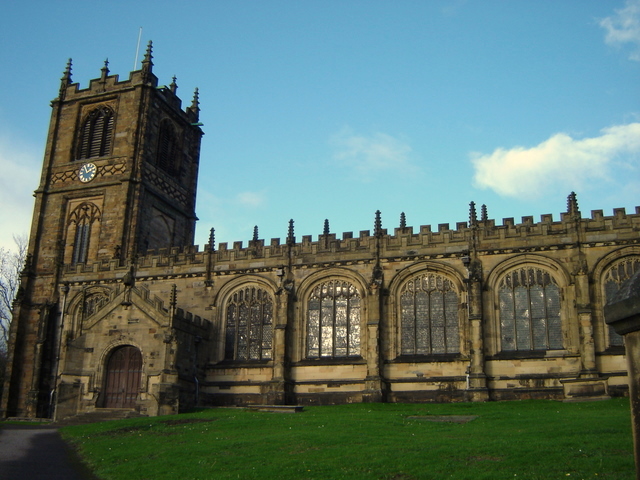
1058:
156:
146:
1189:
811:
712:
646:
606:
562:
471:
265:
1038:
976:
929:
List of church restorations, amendments and furniture by John
Douglas
277:
1253:
1028:
859:
Click on a date/time to view the file as it appeared at that time.
1011:
230:
215:
53° 10′ 06.64″ N, 3° 08′ 39.56″ W
1001:
135:
66:
404:
Add a one-line explanation of what this file represents
917:
967:
857:
90:
Commons is a freely licensed media file repository.
613:
Creative
Commons Attribution-ShareAlike 2.0 Generic
587:
Creative
Commons Attribution-ShareAlike 2.0 Generic
56:(640 × 480 pixels, file size: 187 KB, MIME type:
373:https://creativecommons.org/licenses/by-sa/2.0
71:
379:Creative Commons Attribution-Share Alike 2.0
297:
131:
113:
959:Portal:United Kingdom/Did you know/July 2009
693:https:\/\/www.geograph.org.uk\/photo\/298867
440:https:\/\/www.geograph.org.uk\/profile\/8220
152:
141:
14:
791:
339:– to copy, distribute and transmit the work
969:The following other wikis use this file:
769:https://www.geograph.org.uk/photo/298867
496:https://www.geograph.org.uk/profile/8220
954:Portal:United Kingdom/Did you know/2009
237:View this and other nearby images on:
190:
102:
939:Knowledge:Recent additions/2009/June
284:and is licensed for reuse under the
205:
850:
320:Attribution-Share Alike 2.0 Generic
308:
303:
288:Attribution-ShareAlike 2.0 license.
13:
987:
949:Portal:United Kingdom/Did you know
409:
403:
294:
271:
120:
103:
49:
1278:
994:
408:
1266:09a51127643e6a33ccf1cef1580d8bd4
1049:Date and time of data generation
918:
802:coordinates of the point of view
784:coordinates of the point of view
394:
350:Under the following conditions:
315:This file is licensed under the
307:
302:
296:
264:
243:
229:
221:
70:
31:
21:
391:
121:
46:No higher resolution available.
964:
854:
719:file available on the internet
669:file available on the internet
390:
272:This image was taken from the
52:St_Mary's_Church,_Mold.jpg
26:
1:
1184:Flash did not fire, auto mode
36:
914:
739:Geograph Britain and Ireland
677:Geograph Britain and Ireland
517:object of statement has role
448:object of statement has role
416:Items portrayed in this file
256:
7:
1127:Date and time of digitizing
984:
944:Knowledge:WikiProject Wales
934:St Mary's Church, Mold
817:53°10'6.636"N, 3°8'39.556"W
220:
10:
1283:
973:Usage on cy.wikipedia.org
364:same or compatible license
116:St Mary's Church, Mold.jpg
110:
105:
1092:File change date and time
977:Defnyddiwr:Ham II/Gradd I
924:Joseph Turner (architect)
851:
196:Aaron Thomas /
177:Aaron Thomas /
16:
747:geograph.org.uk image ID
681:geograph.org.uk image ID
393:
330:
77:This is a file from the
41:
1199:Custom image processing
908:
168:required by the license
134:
81:. Information from its
1135:Image compression mode
1130:13:48, 2 December 2006
1095:13:48, 2 December 2006
1052:13:48, 2 December 2006
278:this photograph's page
249:53.168510; -3.144321
198:St Mary's church, Mold
179:St Mary's church, Mold
126:St Mary's church, Mold
84:description page there
1153:Maximum land aperture
1076:Horizontal resolution
1100:Y and C positioning
1084:Vertical resolution
1023:1/160 sec (0.00625)
998:Camera manufacturer
887:11:13, 20 June 2009
345:– to adapt the work
1225:Scene capture type
1220:Auto white balance
504:author name string
444:author name string
1270:
1269:
965:Global file usage
912:
793:
597:copyright license
583:copyright license
402:
293:
292:
276:collection. See
254:
253:
203:
202:
171:
99:
98:
79:Wikimedia Commons
32:Global file usage
1274:
1108:Exposure Program
995:
899:
861:
839:
838:
833:
771:
766:
762:described at URL
756:
751:
741:
736:
689:described at URL
553:copyright status
539:copyright status
526:
521:
511:
508:
498:
493:
400:
386:
383:
380:
377:
374:
366:as the original.
328:
317:Creative Commons
311:
310:
306:
305:
300:
299:
286:Creative Commons
274:Geograph project
268:
261:
250:
247:
233:
232:
226:
225:
224:
218:
217:
206:
165:
137:
125:
117:
111:
95:
74:
73:
67:
61:
59:
1282:
1281:
1277:
1276:
1275:
1273:
1272:
1271:
1263:Unique image ID
1156:3 APEX (f/2.83)
983:
963:
920:
913:
905:
897:
853:
852:
849:
848:
847:
846:
845:
844:
843:
842:
841:
840:
836:
834:
831:
822:
821:
820:
818:
808:
807:
806:
804:
781:
780:
779:
778:
777:
776:
775:
774:
773:
772:
767:
764:
758:
757:
752:
749:
743:
742:
737:
734:
725:
724:
723:
721:
709:
708:
707:
705:
662:
661:
660:
659:
658:
657:
656:
655:
653:
652:2 December 2006
643:
642:
641:
639:
624:
623:
622:
621:
620:
619:
618:
617:
615:
603:
602:
601:
599:
580:
579:
578:
577:
576:
575:
574:
573:
571:
559:
558:
557:
555:
536:
535:
534:
533:
532:
531:
530:
529:
528:
527:
522:
519:
513:
512:
509:
506:
500:
499:
494:
491:
482:
481:
480:
478:
468:
467:
466:
464:
429:
428:
427:
426:
425:
423:
407:
406:
405:
388:
387:
384:
381:
378:
375:
372:
371:
329:
326:
323:
312:
289:
259:
248:
222:
213:
212:
209:Camera location
204:
193:
186:
174:
147:geograph.org.uk
136:2 December 2006
127:
115:
108:
101:
100:
89:
88:
87:is shown below.
63:
57:
55:
48:
47:
12:
11:
5:
1280:
1268:
1267:
1264:
1260:
1259:
1256:
1250:
1249:
1246:
1240:
1239:
1236:
1230:
1229:
1226:
1222:
1221:
1218:
1212:
1211:
1208:
1204:
1203:
1202:Normal process
1200:
1196:
1195:
1192:
1186:
1185:
1182:
1176:
1175:
1172:
1168:
1167:
1164:
1158:
1157:
1154:
1150:
1149:
1146:
1140:
1139:
1136:
1132:
1131:
1128:
1124:
1123:
1120:
1113:
1112:
1111:Normal program
1109:
1105:
1104:
1101:
1097:
1096:
1093:
1089:
1088:
1085:
1081:
1080:
1077:
1073:
1072:
1069:
1065:
1064:
1061:
1054:
1053:
1050:
1046:
1045:
1042:
1035:
1034:
1031:
1025:
1024:
1021:
1015:
1014:
1009:
1005:
1004:
999:
986:
982:
981:
980:
979:
966:
962:
961:
956:
951:
946:
941:
936:
931:
926:
916:
911:
910:
907:
904:Peter I. Vardy
903:
900:
894:
889:
884:
880:
879:
876:
873:
870:
867:
864:
856:
827:
826:
825:
824:
823:
819:
816:
814:
813:
812:
810:
809:
805:
800:
798:
797:
796:
795:
789:
785:
760:
759:
745:
744:
730:
729:
728:
727:
726:
722:
717:
715:
714:
713:
711:
710:
706:
703:source of file
701:
699:
698:
697:
696:
694:
690:
686:
682:
678:
674:
670:
666:
665:source of file
654:
651:
649:
648:
647:
645:
644:
640:
635:
633:
632:
631:
630:
628:
616:
611:
609:
608:
607:
605:
604:
600:
595:
593:
592:
591:
590:
588:
584:
572:
567:
565:
564:
563:
561:
560:
556:
551:
549:
548:
547:
546:
544:
540:
515:
514:
502:
501:
487:
486:
485:
484:
483:
479:
476:
474:
473:
472:
470:
469:
465:
460:
458:
457:
456:
455:
453:
449:
445:
441:
437:
433:
424:
419:
417:
414:
413:
412:
411:
399:
398:
395:
392:
370:
369:
368:
367:
357:
348:
347:
346:
340:
333:You are free:
324:
314:
313:
295:
291:
290:
269:
258:
255:
252:
251:
241:
235:
210:
201:
200:
194:
191:
188:
187:
182:
175:
172:
160:
159:
154:
150:
149:
143:
139:
138:
133:
129:
128:
118:
109:
107:
104:
97:
96:
75:
65:
64:
45:
40:
39:
34:
29:
24:
19:
9:
6:
4:
3:
2:
1279:
1265:
1262:
1261:
1257:
1255:
1252:
1251:
1247:
1245:
1242:
1241:
1237:
1235:
1232:
1231:
1227:
1224:
1223:
1219:
1217:
1216:White balance
1214:
1213:
1210:Auto exposure
1209:
1207:Exposure mode
1206:
1205:
1201:
1198:
1197:
1193:
1191:
1188:
1187:
1183:
1181:
1178:
1177:
1173:
1170:
1169:
1165:
1163:
1162:Metering mode
1160:
1159:
1155:
1152:
1151:
1147:
1145:
1144:Exposure bias
1142:
1141:
1137:
1134:
1133:
1129:
1126:
1125:
1121:
1118:
1115:
1114:
1110:
1107:
1106:
1102:
1099:
1098:
1094:
1091:
1090:
1086:
1083:
1082:
1078:
1075:
1074:
1070:
1067:
1066:
1062:
1060:
1056:
1055:
1051:
1048:
1047:
1043:
1040:
1037:
1036:
1032:
1030:
1027:
1026:
1022:
1020:
1019:Exposure time
1017:
1016:
1013:
1010:
1007:
1006:
1003:
1000:
997:
996:
993:
990:
978:
975:
974:
972:
971:
970:
960:
957:
955:
952:
950:
947:
945:
942:
940:
937:
935:
932:
930:
927:
925:
922:
921:
906:
901:
895:
893:
890:
888:
885:
882:
881:
877:
874:
871:
868:
865:
863:
862:
860:
830:
815:
803:
799:
770:
763:
755:
748:
740:
733:
720:
716:
704:
700:
650:
638:
634:
614:
610:
598:
594:
570:
566:
554:
550:
525:
518:
505:
497:
490:
475:
463:
459:
422:
418:
415:
396:
389:
376:CC BY-SA 2.0
365:
361:
358:
355:
352:
351:
349:
344:
341:
338:
335:
334:
332:
331:
325:Attribution:
321:
318:
301:
287:
283:
279:
275:
270:
267:
263:
262:
246:
242:
240:
239:OpenStreetMap
236:
234:
216:
211:
208:
207:
199:
195:
189:
185:
181: /
180:
176:
169:
164:
162:
161:
158:
155:
151:
148:
144:
140:
130:
124:
119:
112:
93:
86:
85:
80:
76:
69:
68:
62:
53:
44:
38:
35:
33:
30:
28:
25:
23:
20:
18:
15:
1194:Uncalibrated
1171:Light source
1059:focal length
1008:Camera model
991:
988:
968:
858:
855:File history
524:photographer
510:Aaron Thomas
452:photographer
359:
353:
342:
336:
327:Aaron Thomas
282:Aaron Thomas
281:
219:
197:
184:CC BY-SA 2.0
178:
157:Aaron Thomas
122:
92:You can help
82:
50:
22:File history
1190:Color space
1068:Orientation
569:copyrighted
543:copyrighted
360:share alike
354:attribution
163:Attribution
114:Description
1244:Saturation
915:File usage
896:640 × 480
872:Dimensions
477:some value
58:image/jpeg
27:File usage
1254:Sharpness
1039:ISO speed
869:Thumbnail
866:Date/Time
637:inception
627:inception
257:Licensing
192:InfoField
173:InfoField
123:English:
1234:Contrast
1228:Standard
1103:Co-sited
1029:F-number
985:Metadata
898:(187 KB)
732:operator
673:operator
397:Captions
343:to remix
337:to share
322:license.
37:Metadata
1174:Unknown
1166:Pattern
1119:version
1012:DSC-P73
883:current
878:Comment
829:heading
788:heading
462:creator
432:creator
421:depicts
401:English
106:Summary
54:
1258:Normal
1248:Normal
1238:Normal
1087:72 dpi
1079:72 dpi
1041:rating
837:degree
792:degree
754:298867
685:298867
227:
153:Author
142:Source
1180:Flash
1057:Lens
1033:f/5.6
145:From
1117:Exif
1063:6 mm
1002:SONY
875:User
385:true
382:true
132:Date
17:File
1122:2.2
1044:100
835:45
489:URL
436:URL
832::
765::
750::
735::
520::
507::
492::
1148:0
1138:8
1071:0
170:)
166:(
94:.
60:)
