840:"}},"text\/plain":{"en":{"":"coordinates of the point of view"}}},"{\"value\":{\"latitude\":50.28569,\"longitude\":-3.7146,\"altitude\":null,\"precision\":1.0e-5,\"globe\":\"http:\\\/\\\/www.wikidata.org\\\/entity\\\/Q2\"},\"type\":\"globecoordinate\"}":{"text\/html":{"en":{"P1259":"50\u00b017'8.48"N, 3\u00b042'52.56"W"}},"text\/plain":{"en":{"P1259":"50\u00b017'8.48\"N, 3\u00b042'52.56\"W"}}},"{\"value\":{\"entity-type\":\"property\",\"numeric-id\":7787,\"id\":\"P7787\"},\"type\":\"wikibase-entityid\"}":{"text\/html":{"en":{"":"
990:"}},"text\/plain":{"en":{"":"coordinates of depicted place"}}},"{\"value\":{\"latitude\":50.28604,\"longitude\":-3.7152,\"altitude\":null,\"precision\":1.0e-5,\"globe\":\"http:\\\/\\\/www.wikidata.org\\\/entity\\\/Q2\"},\"type\":\"globecoordinate\"}":{"text\/html":{"en":{"P9149":"50\u00b017'9.74"N, 3\u00b042'54.72"W"}},"text\/plain":{"en":{"P9149":"50\u00b017'9.74\"N, 3\u00b042'54.72\"W"}}},"{\"value\":{\"entity-type\":\"property\",\"numeric-id\":7787,\"id\":\"P7787\"},\"type\":\"wikibase-entityid\"}":{"text\/html":{"en":{"":"
952:"}},"text\/plain":{"en":{"":"inception"}}},"{\"value\":{\"time\":\"+1996-08-01T00:00:00Z\",\"timezone\":0,\"before\":0,\"after\":0,\"precision\":10,\"calendarmodel\":\"http:\\\/\\\/www.wikidata.org\\\/entity\\\/Q1985727\"},\"type\":\"time\"}":{"text\/html":{"en":{"P571":"August 1996"}},"text\/plain":{"en":{"P571":"August 1996"}}}}": -->
43:
717:
296:
246:
986:
238:
310:
260:
331:
369:
374:
87:
542:"}},"text\/plain":{"en":{"P2699":"https:\/\/www.geograph.org.uk\/profile\/9419"}}},"{\"value\":{\"entity-type\":\"property\",\"numeric-id\":2093,\"id\":\"P2093\"},\"type\":\"wikibase-entityid\"}":{"text\/html":{"en":{"":"
741:"}},"text\/plain":{"en":{"P973":"https:\/\/www.geograph.org.uk\/photo\/1732072"}}},"{\"value\":{\"entity-type\":\"property\",\"numeric-id\":137,\"id\":\"P137\"},\"type\":\"wikibase-entityid\"}":{"text\/html":{"en":{"":"
1134:
725:"}},"text\/plain":{"en":{"P7482":"file available on the internet"}}},"{\"value\":{\"entity-type\":\"property\",\"numeric-id\":7384,\"id\":\"P7384\"},\"type\":\"wikibase-entityid\"}":{"text\/html":{"en":{"":"
546:"}},"text\/plain":{"en":{"":"author name string"}}},"{\"value\":\"John Salmon\",\"type\":\"string\"}":{"text\/html":{"en":{"P2093":"John Salmon"}},"text\/plain":{"en":{"P2093":"John Salmon"}}}}": -->
530:"}},"text\/plain":{"en":{"":"object of statement has role"}}},"{\"value\":{\"entity-type\":\"item\",\"numeric-id\":33231,\"id\":\"Q33231\"},\"type\":\"wikibase-entityid\"}":{"text\/html":{"en":{"P3831":"
908:"}},"text\/plain":{"en":{"":"location of creation"}}},"{\"value\":{\"entity-type\":\"item\",\"numeric-id\":16992530,\"id\":\"Q16992530\"},\"type\":\"wikibase-entityid\"}":{"text\/html":{"en":{"P1071":"
1058:"}},"text\/plain":{"en":{"":"media type"}}},"{\"value\":\"image\\\/jpeg\",\"type\":\"string\"}":{"text\/html":{"en":{"P1163":"image\/jpeg"}},"text\/plain":{"en":{"P1163":"image\/jpeg"}}}}": -->
677:"}},"text\/plain":{"en":{"":"copyright license"}}},"{\"value\":{\"entity-type\":\"item\",\"numeric-id\":19068220,\"id\":\"Q19068220\"},\"type\":\"wikibase-entityid\"}":{"text\/html":{"en":{"P275":"
633:"}},"text\/plain":{"en":{"":"copyright status"}}},"{\"value\":{\"entity-type\":\"item\",\"numeric-id\":50423863,\"id\":\"Q50423863\"},\"type\":\"wikibase-entityid\"}":{"text\/html":{"en":{"P6216":"
721:"}},"text\/plain":{"en":{"":"source of file"}}},"{\"value\":{\"entity-type\":\"item\",\"numeric-id\":74228490,\"id\":\"Q74228490\"},\"type\":\"wikibase-entityid\"}":{"text\/html":{"en":{"P7482":"
534:"}},"text\/plain":{"en":{"P3831":"photographer"}}},"{\"value\":{\"entity-type\":\"property\",\"numeric-id\":2699,\"id\":\"P2699\"},\"type\":\"wikibase-entityid\"}":{"text\/html":{"en":{"":"
994:"}},"text\/plain":{"en":{"":"heading"}}},"{\"value\":{\"amount\":\"+315\",\"unit\":\"http:\\\/\\\/www.wikidata.org\\\/entity\\\/Q28390\"},\"type\":\"quantity\"}":{"text\/html":{"en":{"P7787":"315
844:"}},"text\/plain":{"en":{"":"heading"}}},"{\"value\":{\"amount\":\"+315\",\"unit\":\"http:\\\/\\\/www.wikidata.org\\\/entity\\\/Q28390\"},\"type\":\"quantity\"}":{"text\/html":{"en":{"P7787":"315
745:"}},"text\/plain":{"en":{"":"operator"}}},"{\"value\":{\"entity-type\":\"item\",\"numeric-id\":1503119,\"id\":\"Q1503119\"},\"type\":\"wikibase-entityid\"}":{"text\/html":{"en":{"P137":"
733:"}},"text\/plain":{"en":{"P7384":"1732072"}}},"{\"value\":{\"entity-type\":\"property\",\"numeric-id\":973,\"id\":\"P973\"},\"type\":\"wikibase-entityid\"}":{"text\/html":{"en":{"":"
479:"}},"text\/plain":{"en":{"":"depicts"}}},"{\"value\":{\"entity-type\":\"item\",\"numeric-id\":16970,\"id\":\"Q16970\"},\"type\":\"wikibase-entityid\"}":{"text\/html":{"en":{"P180":"
526:"}},"text\/plain":{"en":{"":"creator"}}},"{\"value\":{\"entity-type\":\"property\",\"numeric-id\":3831,\"id\":\"P3831\"},\"type\":\"wikibase-entityid\"}":{"text\/html":{"en":{"":"
1054:
229:
729:"}},"text\/plain":{"en":{"":"geograph.org.uk image ID"}}},"{\"value\":\"1732072\",\"type\":\"string\"}":{"text\/html":{"en":{"P7384":"
53:
47:
421:– You must give appropriate credit, provide a link to the license, and indicate if changes were made. You may do so in any reasonable manner, but not in any way that suggests the licensor endorses you or your use.
66:
98:
293:
243:
730:
909:
722:
678:
634:
746:
531:
480:
1055:
991:
987:
905:
841:
837:
726:
718:
630:
543:
535:
527:
738:
949:
742:
734:
674:
539:
523:
476:
1144:
1151:== {{int:filedesc}} == {{Information |description={{en|1=St Martin of Tours, Sherford, Devon}} |date=1996-08 |source=From |author= |permission=
681:"}},"text\/plain":{"en":{"P275":"Creative Commons Attribution-ShareAlike 2.0 Generic"}}}}": -->
1133:
1128:
57:
42:
935:
772:
704:
660:
303:
253:
1165:
822:
338:
1201:
This file contains additional information, probably added from the digital camera or scanner used to create or digitize it.
428:
587:
509:
1065:
1032:
1005:
919:
882:
855:
785:
756:
644:
610:
595:
580:
959:
815:
800:
688:
553:
493:
749:"}},"text\/plain":{"en":{"P137":"Geograph Britain and Ireland"}}}}": -->
912:"}},"text\/plain":{"en":{"P1071":"Frogmore and Sherford"}}}}": -->
384:
1204:
If the file has been modified from its original state, some details may not fully reflect the modified file.
1237:
1170:
483:"}},"text\/plain":{"en":{"P180":"church building"}}}}": -->
427:– If you remix, transform, or build upon the material, you must distribute your contributions under the
345:
on the
Geograph website for the photographer's contact details. The copyright on this image is owned by
637:"}},"text\/plain":{"en":{"P6216":"copyrighted"}}}}": -->
1161:
The following pages on the
English Knowledge use this file (pages on other projects are not listed):
998:"}},"text\/plain":{"en":{"P7787":"315 degree"}}}}": -->
848:"}},"text\/plain":{"en":{"P7787":"315 degree"}}}}": -->
106:
198:
807:
792:
602:
381:
182:
8:
325:
309:
259:
350:
93:
161:
171:
1075:
1015:
969:
929:
865:
766:
698:
654:
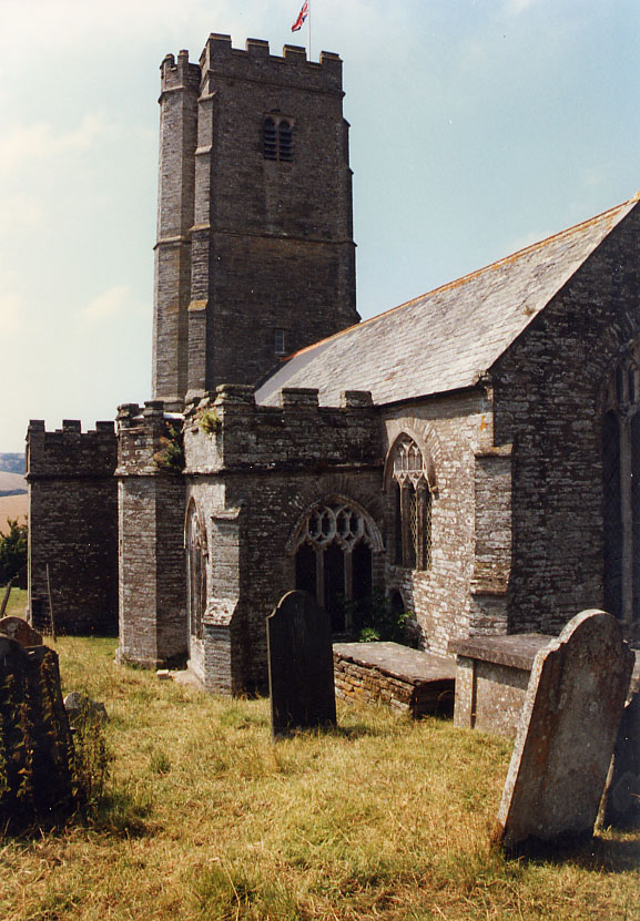
563:
503:
1252:
330:
342:
1101:
Click on a date/time to view the file as it appeared at that time.
131:
St Martin of Tours, Sherford, Devon - geograph.org.uk - 1732072.jpg
295:
245:
280:
50° 17′ 10″ N, 3° 42′ 55″ W
230:
50° 17′ 08″ N, 3° 42′ 53″ W
81:
469:
Add a one-line explanation of what this file represents
1188:
150:
1159:
1179:
1099:
105:
Commons is a freely licensed media file repository.
705:
Creative
Commons Attribution-ShareAlike 2.0 Generic
679:
Creative
Commons Attribution-ShareAlike 2.0 Generic
71:(577 × 831 pixels, file size: 182 KB, MIME type:
438:https://creativecommons.org/licenses/by-sa/2.0
86:
739:https:\/\/www.geograph.org.uk\/photo\/1732072
444:Creative Commons Attribution-Share Alike 2.0
362:
146:
128:
540:https:\/\/www.geograph.org.uk\/profile\/9419
167:
156:
14:
995:
845:
404:– to copy, distribute and transmit the work
1181:The following other wikis use this file:
808:https://www.geograph.org.uk/photo/1732072
603:https://www.geograph.org.uk/profile/9419
1166:Grade I listed buildings in South Hams
302:View this and other nearby images on:
252:View this and other nearby images on:
205:
117:
349:and is licensed for reuse under the
270:
220:
1092:
385:Attribution-Share Alike 2.0 Generic
373:
368:
353:Attribution-ShareAlike 2.0 license.
213:St Martin of Tours, Sherford, Devon
194:St Martin of Tours, Sherford, Devon
141:St Martin of Tours, Sherford, Devon
13:
1199:
474:
468:
359:
336:
135:
118:
64:
1269:
1206:
473:
1160:
856:coordinates of the point of view
838:coordinates of the point of view
459:
415:Under the following conditions:
380:This file is licensed under the
372:
367:
361:
329:
308:
294:
286:
258:
244:
236:
85:
31:
21:
456:
136:
1176:
1096:
773:file available on the internet
723:file available on the internet
455:
337:This image was taken from the
26:
1:
1006:coordinates of depicted place
988:coordinates of depicted place
36:
1156:
823:Geograph Britain and Ireland
747:Geograph Britain and Ireland
581:object of statement has role
528:object of statement has role
489:Items portrayed in this file
321:
285:
235:
7:
1238:Adobe Photoshop CS2 Windows
1196:
1171:Sherford (near Kingsbridge)
10:
1274:
1185:Usage on www.wikidata.org
1021:50°17'9.74"N, 3°42'54.72"W
871:50°17'8.48"N, 3°42'52.56"W
429:same or compatible license
125:
120:
1244:File change date and time
1093:
16:
786:geograph.org.uk image ID
727:geograph.org.uk image ID
458:
395:
211:John Salmon /
192:John Salmon /
92:This is a file from the
41:
1150:
183:required by the license
149:
96:. Information from its
343:this photograph's page
314:50.286040; -3.715200
264:50.285690; -3.714600
99:description page there
46:Size of this preview:
1218:Horizontal resolution
936:Frogmore and Sherford
910:Frogmore and Sherford
920:location of creation
906:location of creation
1247:15:27, 2 March 2010
1226:Vertical resolution
1129:16:30, 5 March 2011
410:– to adapt the work
52:Other resolutions:
611:author name string
544:author name string
1261:
1260:
1177:Global file usage
1154:
997:
847:
689:copyright license
675:copyright license
467:
358:
357:
341:collection. See
319:
318:
269:
268:
218:
217:
186:
114:
113:
94:Wikimedia Commons
32:Global file usage
1265:
1207:
1141:
1103:
1043:
1042:
1037:
893:
892:
887:
825:
820:
810:
805:
801:described at URL
795:
790:
735:described at URL
645:copyright status
631:copyright status
618:
615:
605:
600:
590:
585:
465:
451:
448:
445:
442:
439:
431:as the original.
393:
382:Creative Commons
376:
375:
371:
370:
365:
364:
351:Creative Commons
339:Geograph project
333:
326:
315:
312:
298:
297:
291:
290:
289:
283:
282:
271:
265:
262:
248:
247:
241:
240:
239:
233:
232:
221:
180:
152:
140:
132:
126:
110:
89:
88:
82:
76:
74:
61:
58:577 × 831 pixels
54:166 × 240 pixels
48:416 × 599 pixels
1273:
1272:
1268:
1267:
1266:
1264:
1263:
1262:
1195:
1175:
1162:
1155:
1147:
1139:
1095:
1094:
1091:
1090:
1089:
1088:
1087:
1086:
1085:
1084:
1082:
1072:
1071:
1070:
1068:
1053:
1052:
1051:
1050:
1049:
1048:
1047:
1046:
1045:
1044:
1040:
1038:
1035:
1026:
1025:
1024:
1022:
1012:
1011:
1010:
1008:
985:
984:
983:
982:
981:
980:
979:
978:
976:
966:
965:
964:
962:
947:
946:
945:
944:
943:
942:
941:
940:
938:
926:
925:
924:
922:
903:
902:
901:
900:
899:
898:
897:
896:
895:
894:
890:
888:
885:
876:
875:
874:
872:
862:
861:
860:
858:
835:
834:
833:
832:
831:
830:
829:
828:
827:
826:
821:
818:
812:
811:
806:
803:
797:
796:
791:
788:
779:
778:
777:
775:
763:
762:
761:
759:
716:
715:
714:
713:
712:
711:
710:
709:
707:
695:
694:
693:
691:
672:
671:
670:
669:
668:
667:
666:
665:
663:
651:
650:
649:
647:
628:
627:
626:
625:
624:
623:
622:
621:
620:
619:
616:
613:
607:
606:
601:
598:
592:
591:
586:
583:
574:
573:
572:
570:
560:
559:
558:
556:
521:
520:
519:
518:
517:
516:
515:
514:
512:
510:church building
500:
499:
498:
496:
481:church building
472:
471:
470:
453:
452:
449:
446:
443:
440:
437:
436:
394:
391:
388:
377:
354:
324:
313:
287:
278:
277:
274:Object location
263:
237:
228:
227:
224:Camera location
219:
208:
201:
189:
162:geograph.org.uk
142:
130:
123:
116:
115:
104:
103:
102:is shown below.
78:
72:
70:
63:
62:
51:
12:
11:
5:
1271:
1259:
1258:
1255:
1249:
1248:
1245:
1241:
1240:
1235:
1231:
1230:
1227:
1223:
1222:
1219:
1215:
1214:
1211:
1198:
1194:
1193:
1192:
1191:
1178:
1174:
1173:
1168:
1158:
1153:
1152:
1149:
1145:
1142:
1136:
1131:
1126:
1122:
1121:
1118:
1115:
1112:
1109:
1106:
1098:
1083:
1080:
1078:
1077:
1076:
1074:
1073:
1069:
1064:
1062:
1061:
1060:
1059:
1057:
1031:
1030:
1029:
1028:
1027:
1023:
1020:
1018:
1017:
1016:
1014:
1013:
1009:
1004:
1002:
1001:
1000:
999:
993:
989:
977:
974:
972:
971:
970:
968:
967:
963:
958:
956:
955:
954:
953:
951:
939:
934:
932:
931:
930:
928:
927:
923:
918:
916:
915:
914:
913:
911:
907:
881:
880:
879:
878:
877:
873:
870:
868:
867:
866:
864:
863:
859:
854:
852:
851:
850:
849:
843:
839:
814:
813:
799:
798:
784:
783:
782:
781:
780:
776:
771:
769:
768:
767:
765:
764:
760:
757:source of file
755:
753:
752:
751:
750:
748:
744:
740:
736:
732:
728:
724:
720:
719:source of file
708:
703:
701:
700:
699:
697:
696:
692:
687:
685:
684:
683:
682:
680:
676:
664:
659:
657:
656:
655:
653:
652:
648:
643:
641:
640:
639:
638:
636:
632:
609:
608:
594:
593:
579:
578:
577:
576:
575:
571:
568:
566:
565:
564:
562:
561:
557:
552:
550:
549:
548:
547:
545:
541:
537:
533:
529:
525:
513:
508:
506:
505:
504:
502:
501:
497:
492:
490:
487:
486:
485:
484:
482:
478:
464:
463:
460:
457:
435:
434:
433:
432:
422:
413:
412:
411:
405:
398:You are free:
389:
379:
378:
360:
356:
355:
334:
323:
320:
317:
316:
306:
300:
275:
267:
266:
256:
250:
225:
216:
215:
209:
206:
203:
202:
197:
190:
187:
175:
174:
169:
165:
164:
158:
154:
153:
148:
144:
143:
133:
124:
122:
119:
112:
111:
90:
80:
79:
45:
40:
39:
34:
29:
24:
19:
9:
6:
4:
3:
2:
1270:
1256:
1254:
1251:
1250:
1246:
1243:
1242:
1239:
1236:
1234:Software used
1233:
1232:
1228:
1225:
1224:
1220:
1217:
1216:
1212:
1209:
1208:
1205:
1202:
1190:
1187:
1186:
1184:
1183:
1182:
1172:
1169:
1167:
1164:
1163:
1148:
1143:
1137:
1135:
1132:
1130:
1127:
1124:
1123:
1119:
1116:
1113:
1110:
1107:
1105:
1104:
1102:
1079:
1067:
1063:
1034:
1019:
1007:
1003:
973:
961:
957:
937:
933:
921:
917:
884:
869:
857:
853:
824:
817:
809:
802:
794:
787:
774:
770:
758:
754:
706:
702:
690:
686:
662:
658:
646:
642:
612:
604:
597:
589:
582:
567:
555:
551:
511:
507:
495:
491:
488:
461:
454:
441:CC BY-SA 2.0
430:
426:
423:
420:
417:
416:
414:
409:
406:
403:
400:
399:
397:
396:
390:Attribution:
386:
383:
366:
352:
348:
344:
340:
335:
332:
328:
327:
311:
307:
305:
304:OpenStreetMap
301:
299:
281:
276:
273:
272:
261:
257:
255:
254:OpenStreetMap
251:
249:
231:
226:
223:
222:
214:
210:
204:
200:
196: /
195:
191:
184:
179:
177:
176:
173:
170:
166:
163:
159:
155:
145:
139:
134:
127:
108:
101:
100:
95:
91:
84:
83:
77:
68:
67:Original file
59:
55:
49:
44:
38:
35:
33:
30:
28:
25:
23:
20:
18:
15:
1203:
1200:
1180:
1100:
1097:File history
588:photographer
532:photographer
424:
418:
407:
401:
346:
284:
234:
212:
199:CC BY-SA 2.0
193:
137:
107:You can help
97:
65:
22:File history
1253:Color space
1210:Orientation
1146:GeographBot
975:August 1996
661:copyrighted
635:copyrighted
617:John Salmon
425:share alike
419:attribution
392:John Salmon
347:John Salmon
178:Attribution
172:John Salmon
151:August 1996
129:Description
1157:File usage
1138:577 × 831
1114:Dimensions
1081:image/jpeg
1066:media type
1056:media type
569:some value
73:image/jpeg
27:File usage
1189:Q17527045
1111:Thumbnail
1108:Date/Time
960:inception
950:inception
322:Licensing
207:InfoField
188:InfoField
138:English:
1197:Metadata
1140:(182 KB)
816:operator
743:operator
462:Captions
408:to remix
402:to share
387:license.
37:Metadata
1229:150 dpi
1221:150 dpi
1125:current
1120:Comment
1033:heading
992:heading
883:heading
842:heading
793:1732072
731:1732072
554:creator
524:creator
494:depicts
477:depicts
466:English
121:Summary
69:
1213:Normal
1041:degree
996:degree
891:degree
846:degree
292:
242:
168:Author
157:Source
160:From
1257:sRGB
1117:User
1039:315
889:315
450:true
447:true
147:Date
17:File
596:URL
536:URL
1036::
886::
819::
804::
789::
614::
599::
584::
56:|
50:.
185:)
181:(
109:.
75:)
60:.
Text is available under the Creative Commons Attribution-ShareAlike License. Additional terms may apply.
_heading:315.00&language=en)
_heading:315.00&language=en)
