Index
FileFile history
File usage
Metadata

800 × 512 pixels
320 × 205 pixels
640 × 409 pixels
1,024 × 655 pixels
1,600 × 1,023 pixels
Original file
Wikimedia Commons
description page there
You can help
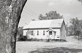
St. Margaret's Anglican Church, Cecil Plains, Queensland, 1975
27° 32′ 03.84″ S, 151° 11′ 31.92″ E
OpenStreetMap
Creative Commons
Attribution 4.0 International
depicts<\/a>"}},"text\/plain":{"en":{"":"depicts"}}},"{\"value\":{\"entity-type\":\"item\",\"numeric-id\":56242045,\"id\":\"Q56242045\"},\"type\":\"wikibase-entityid\"}":{"text\/html":{"en":{"P180":"Anglican church building<\/a>"}},"text\/plain":{"en":{"P180":"Anglican church building"}}},"{\"value\":{\"entity-type\":\"item\",\"numeric-id\":5056273,\"id\":\"Q5056273\"},\"type\":\"wikibase-entityid\"}":{"text\/html":{"en":{"P180":"Cecil Plains<\/a>"}},"text\/plain":{"en":{"P180":"Cecil Plains"}}}}">
Items portrayed in this file
depicts
Anglican church building
Cecil Plains
copyright status<\/a>"}},"text\/plain":{"en":{"":"copyright status"}}},"{\"value\":{\"entity-type\":\"item\",\"numeric-id\":50423863,\"id\":\"Q50423863\"},\"type\":\"wikibase-entityid\"}":{"text\/html":{"en":{"P6216":"copyrighted<\/a>"}},"text\/plain":{"en":{"P6216":"copyrighted"}}}}">copyright status
copyrighted
copyright license<\/a>"}},"text\/plain":{"en":{"":"copyright license"}}},"{\"value\":{\"entity-type\":\"item\",\"numeric-id\":20007257,\"id\":\"Q20007257\"},\"type\":\"wikibase-entityid\"}":{"text\/html":{"en":{"P275":"Creative Commons Attribution 4.0 International<\/a>"}},"text\/plain":{"en":{"P275":"Creative Commons Attribution 4.0 International"}}}}">copyright license
Creative Commons Attribution 4.0 International
inception<\/a>"}},"text\/plain":{"en":{"":"inception"}}},"{\"value\":{\"time\":\"+1975-01-01T00:00:00Z\",\"timezone\":0,\"before\":0,\"after\":0,\"precision\":9,\"calendarmodel\":\"http:\\\/\\\/www.wikidata.org\\\/entity\\\/Q1985727\"},\"type\":\"time\"}":{"text\/html":{"en":{"P571":"1975"}},"text\/plain":{"en":{"P571":"1975"}}}}">inception
coordinates of the point of view<\/a>"}},"text\/plain":{"en":{"":"coordinates of the point of view"}}},"{\"value\":{\"latitude\":-27.5344,\"longitude\":151.1922,\"altitude\":null,\"precision\":0.0001,\"globe\":\"http:\\\/\\\/www.wikidata.org\\\/entity\\\/Q2\"},\"type\":\"globecoordinate\"}":{"text\/html":{"en":{"P1259":"27\u00b032'3.8"S, 151\u00b011'31.9"E"}},"text\/plain":{"en":{"P1259":"27\u00b032'3.8\"S, 151\u00b011'31.9\"E"}}}}">
Text is available under the Creative Commons Attribution-ShareAlike License. Additional terms may apply.
↑
copyright status
copyrighted
copyright license<\/a>"}},"text\/plain":{"en":{"":"copyright license"}}},"{\"value\":{\"entity-type\":\"item\",\"numeric-id\":20007257,\"id\":\"Q20007257\"},\"type\":\"wikibase-entityid\"}":{"text\/html":{"en":{"P275":"Creative Commons Attribution 4.0 International<\/a>"}},"text\/plain":{"en":{"P275":"Creative Commons Attribution 4.0 International"}}}}">copyright license
Creative Commons Attribution 4.0 International
inception<\/a>"}},"text\/plain":{"en":{"":"inception"}}},"{\"value\":{\"time\":\"+1975-01-01T00:00:00Z\",\"timezone\":0,\"before\":0,\"after\":0,\"precision\":9,\"calendarmodel\":\"http:\\\/\\\/www.wikidata.org\\\/entity\\\/Q1985727\"},\"type\":\"time\"}":{"text\/html":{"en":{"P571":"1975"}},"text\/plain":{"en":{"P571":"1975"}}}}">inception
coordinates of the point of view<\/a>"}},"text\/plain":{"en":{"":"coordinates of the point of view"}}},"{\"value\":{\"latitude\":-27.5344,\"longitude\":151.1922,\"altitude\":null,\"precision\":0.0001,\"globe\":\"http:\\\/\\\/www.wikidata.org\\\/entity\\\/Q2\"},\"type\":\"globecoordinate\"}":{"text\/html":{"en":{"P1259":"27\u00b032'3.8"S, 151\u00b011'31.9"E"}},"text\/plain":{"en":{"P1259":"27\u00b032'3.8\"S, 151\u00b011'31.9\"E"}}}}">
Text is available under the Creative Commons Attribution-ShareAlike License. Additional terms may apply.
↑
copyright license
Creative Commons Attribution 4.0 International
inception<\/a>"}},"text\/plain":{"en":{"":"inception"}}},"{\"value\":{\"time\":\"+1975-01-01T00:00:00Z\",\"timezone\":0,\"before\":0,\"after\":0,\"precision\":9,\"calendarmodel\":\"http:\\\/\\\/www.wikidata.org\\\/entity\\\/Q1985727\"},\"type\":\"time\"}":{"text\/html":{"en":{"P571":"1975"}},"text\/plain":{"en":{"P571":"1975"}}}}">inception
coordinates of the point of view<\/a>"}},"text\/plain":{"en":{"":"coordinates of the point of view"}}},"{\"value\":{\"latitude\":-27.5344,\"longitude\":151.1922,\"altitude\":null,\"precision\":0.0001,\"globe\":\"http:\\\/\\\/www.wikidata.org\\\/entity\\\/Q2\"},\"type\":\"globecoordinate\"}":{"text\/html":{"en":{"P1259":"27\u00b032'3.8"S, 151\u00b011'31.9"E"}},"text\/plain":{"en":{"P1259":"27\u00b032'3.8\"S, 151\u00b011'31.9\"E"}}}}">
Text is available under the Creative Commons Attribution-ShareAlike License. Additional terms may apply.
↑
inception
coordinates of the point of view<\/a>"}},"text\/plain":{"en":{"":"coordinates of the point of view"}}},"{\"value\":{\"latitude\":-27.5344,\"longitude\":151.1922,\"altitude\":null,\"precision\":0.0001,\"globe\":\"http:\\\/\\\/www.wikidata.org\\\/entity\\\/Q2\"},\"type\":\"globecoordinate\"}":{"text\/html":{"en":{"P1259":"27\u00b032'3.8"S, 151\u00b011'31.9"E"}},"text\/plain":{"en":{"P1259":"27\u00b032'3.8\"S, 151\u00b011'31.9\"E"}}}}">
Text is available under the Creative Commons Attribution-ShareAlike License. Additional terms may apply.
↑
Text is available under the Creative Commons Attribution-ShareAlike License. Additional terms may apply.
↑