826:"}},"text\/plain":{"en":{"":"coordinates of depicted place"}}},"{\"value\":{\"latitude\":53.3291,\"longitude\":-0.146,\"altitude\":null,\"precision\":0.0001,\"globe\":\"http:\\\/\\\/www.wikidata.org\\\/entity\\\/Q2\"},\"type\":\"globecoordinate\"}":{"text\/html":{"en":{"P9149":"53\u00b019'44.8"N, 0\u00b08'45.6"W"}},"text\/plain":{"en":{"P9149":"53\u00b019'44.8\"N, 0\u00b08'45.6\"W"}}}}": -->
744:"}},"text\/plain":{"en":{"":"inception"}}},"{\"value\":{\"time\":\"+2006-01-04T00:00:00Z\",\"timezone\":0,\"before\":0,\"after\":0,\"precision\":11,\"calendarmodel\":\"http:\\\/\\\/www.wikidata.org\\\/entity\\\/Q1985727\"},\"type\":\"time\"}":{"text\/html":{"en":{"P571":"4 January 2006"}},"text\/plain":{"en":{"P571":"4 January 2006"}}}}": -->
621:
426:
238:
262:
300:
305:
1150:
72:
992:"}},"text\/plain":{"en":{"":"ISO speed"}}},"{\"value\":{\"amount\":\"+100\",\"unit\":\"1\"},\"type\":\"quantity\"}":{"text\/html":{"en":{"P6789":"100"}},"text\/plain":{"en":{"P6789":"100"}}}}": -->
909:"}},"text\/plain":{"en":{"":"f-number"}}},"{\"value\":{\"amount\":\"+4\",\"unit\":\"1\"},\"type\":\"quantity\"}":{"text\/html":{"en":{"P6790":"4"}},"text\/plain":{"en":{"P6790":"4"}}}}": -->
438:"}},"text\/plain":{"en":{"P2699":"https:\/\/www.geograph.org.uk\/profile\/1904"}}},"{\"value\":{\"entity-type\":\"property\",\"numeric-id\":3831,\"id\":\"P3831\"},\"type\":\"wikibase-entityid\"}":{"text\/html":{"en":{"":"
637:"}},"text\/plain":{"en":{"P973":"https:\/\/www.geograph.org.uk\/photo\/101201"}}},"{\"value\":{\"entity-type\":\"property\",\"numeric-id\":137,\"id\":\"P137\"},\"type\":\"wikibase-entityid\"}":{"text\/html":{"en":{"":"
450:"}},"text\/plain":{"en":{"":"author name string"}}},"{\"value\":\"Richard Croft\",\"type\":\"string\"}":{"text\/html":{"en":{"P2093":"Richard Croft"}},"text\/plain":{"en":{"P2093":"Richard Croft"}}}}": -->
629:"}},"text\/plain":{"en":{"P7482":"file available on the internet"}}},"{\"value\":{\"entity-type\":\"property\",\"numeric-id\":973,\"id\":\"P973\"},\"type\":\"wikibase-entityid\"}":{"text\/html":{"en":{"":"
645:"}},"text\/plain":{"en":{"P137":"Geograph Britain and Ireland"}}},"{\"value\":{\"entity-type\":\"property\",\"numeric-id\":7384,\"id\":\"P7384\"},\"type\":\"wikibase-entityid\"}":{"text\/html":{"en":{"":"
442:"}},"text\/plain":{"en":{"":"object of statement has role"}}},"{\"value\":{\"entity-type\":\"item\",\"numeric-id\":33231,\"id\":\"Q33231\"},\"type\":\"wikibase-entityid\"}":{"text\/html":{"en":{"P3831":"
1030:"}},"text\/plain":{"en":{"":"media type"}}},"{\"value\":\"image\\\/jpeg\",\"type\":\"string\"}":{"text\/html":{"en":{"P1163":"image\/jpeg"}},"text\/plain":{"en":{"P1163":"image\/jpeg"}}}}": -->
581:"}},"text\/plain":{"en":{"":"copyright license"}}},"{\"value\":{\"entity-type\":\"item\",\"numeric-id\":19068220,\"id\":\"Q19068220\"},\"type\":\"wikibase-entityid\"}":{"text\/html":{"en":{"P275":"
537:"}},"text\/plain":{"en":{"":"copyright status"}}},"{\"value\":{\"entity-type\":\"item\",\"numeric-id\":50423863,\"id\":\"Q50423863\"},\"type\":\"wikibase-entityid\"}":{"text\/html":{"en":{"P6216":"
864:"}},"text\/plain":{"en":{"":"exposure time"}}},"{\"value\":{\"amount\":\"+0.025\",\"unit\":\"http:\\\/\\\/www.wikidata.org\\\/entity\\\/Q11574\"},\"type\":\"quantity\"}":{"text\/html":{"en":{"P6757":"0.025
625:"}},"text\/plain":{"en":{"":"source of file"}}},"{\"value\":{\"entity-type\":\"item\",\"numeric-id\":74228490,\"id\":\"Q74228490\"},\"type\":\"wikibase-entityid\"}":{"text\/html":{"en":{"P7482":"
947:"}},"text\/plain":{"en":{"":"focal length"}}},"{\"value\":{\"amount\":\"+22\",\"unit\":\"http:\\\/\\\/www.wikidata.org\\\/entity\\\/Q174789\"},\"type\":\"quantity\"}":{"text\/html":{"en":{"P2151":"22
446:"}},"text\/plain":{"en":{"P3831":"photographer"}}},"{\"value\":{\"entity-type\":\"property\",\"numeric-id\":2093,\"id\":\"P2093\"},\"type\":\"wikibase-entityid\"}":{"text\/html":{"en":{"":"
782:"}},"text\/plain":{"en":{"":"captured with"}}},"{\"value\":{\"entity-type\":\"item\",\"numeric-id\":64072,\"id\":\"Q64072\"},\"type\":\"wikibase-entityid\"}":{"text\/html":{"en":{"P4082":"
1068:"}},"text\/plain":{"en":{"":"instance of"}}},"{\"value\":{\"entity-type\":\"item\",\"numeric-id\":125191,\"id\":\"Q125191\"},\"type\":\"wikibase-entityid\"}":{"text\/html":{"en":{"P31":"
641:"}},"text\/plain":{"en":{"":"operator"}}},"{\"value\":{\"entity-type\":\"item\",\"numeric-id\":1503119,\"id\":\"Q1503119\"},\"type\":\"wikibase-entityid\"}":{"text\/html":{"en":{"P137":"
430:"}},"text\/plain":{"en":{"":"creator"}}},"{\"value\":{\"entity-type\":\"property\",\"numeric-id\":2699,\"id\":\"P2699\"},\"type\":\"wikibase-entityid\"}":{"text\/html":{"en":{"":"
1026:
1064:
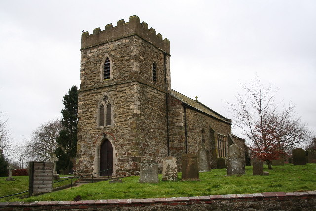
1167:== {{int:filedesc}} == {{Information |description={{en|1=St. Andrew's church, Donington on Bain, Lincs. St. Andrew's has a Norman tower and font with later medieval gothic additions. There's also an early 17th century brass to a former rector "... the lea
649:"}},"text\/plain":{"en":{"":"geograph.org.uk image ID"}}},"{\"value\":\"101201\",\"type\":\"string\"}":{"text\/html":{"en":{"P7384":"
51:
83:
126:
St. Andrew's church, Donington on Bain, Lincs. St. Andrew's has a Norman tower and font with later medieval gothic additions. There's also an early 17th century brass to a former rector "... the learned, prudent, pious Thomas Kent
352:– You must give appropriate credit, provide a link to the license, and indicate if changes were made. You may do so in any reasonable manner, but not in any way that suggests the licensor endorses you or your use.
221:
650:
626:
582:
538:
642:
1069:
783:
443:
1027:
989:
944:
906:
861:
823:
779:
646:
622:
534:
447:
439:
431:
741:
638:
634:
630:
578:
435:
427:
1065:
1160:
1149:
1144:
42:
585:"}},"text\/plain":{"en":{"P275":"Creative Commons Attribution-ShareAlike 2.0 Generic"}}}}": -->
1186:
1234:
676:
608:
564:
231:
711:
269:
1312:
This file contains additional information, probably added from the digital camera or scanner used to create or digitize it.
1095:
359:
809:
506:
1037:
999:
958:
916:
875:
833:
793:
719:
660:
548:
514:
499:
484:
751:
704:
689:
592:
457:
416:
1079:
1439:
315:
1315:
If the file has been modified from its original state, some details may not fully reflect the modified file.
786:"}},"text\/plain":{"en":{"P4082":"Canon EOS 350D"}}}}": -->
358:– If you remix, transform, or build upon the material, you must distribute your contributions under the
276:
on the
Geograph website for the photographer's contact details. The copyright on this image is owned by
951:"}},"text\/plain":{"en":{"P2151":"22 millimetre"}}}}": -->
868:"}},"text\/plain":{"en":{"P6757":"0.025 second"}}}}": -->
541:"}},"text\/plain":{"en":{"P6216":"copyrighted"}}}}": -->
1177:
The following pages on the
English Knowledge use this file (pages on other projects are not listed):
1072:"}},"text\/plain":{"en":{"P31":"photograph"}}}}": -->
91:
653:"}},"text\/plain":{"en":{"P7384":"101201"}}}}": -->
184:
1334:
1476:
726:
696:
491:
312:
168:
8:
1496:
256:
237:
1181:
281:
78:
406:
1324:
52:
St._Andrew's_church,_Donington_on_Bain,_Lincs_-_geograph.org.uk_-_101201.jpg
1556:
1486:
1458:
1341:
116:
St. Andrew's church, Donington on Bain, Lincs - geograph.org.uk - 101201.jpg
1381:
157:
147:
1506:
1089:
1047:
1009:
968:
926:
885:
843:
803:
761:
670:
602:
558:
467:
261:
1361:
273:
1351:
1117:
Click on a date/time to view the file as it appeared at that time.
223:
1264:
1224:
1204:
1284:
1274:
1254:
1244:
1214:
216:
53° 19′ 45″ N, 0° 08′ 46″ W
136:
66:
400:
Add a one-line explanation of what this file represents
1299:
1294:
1175:
1195:
1115:
90:
Commons is a freely licensed media file repository.
609:
Creative
Commons Attribution-ShareAlike 2.0 Generic
583:
Creative
Commons Attribution-ShareAlike 2.0 Generic
1501:Flash did not fire, compulsory flash suppression
56:(640 × 427 pixels, file size: 95 KB, MIME type:
369:https://creativecommons.org/licenses/by-sa/2.0
71:
375:Creative Commons Attribution-Share Alike 2.0
293:
199:St. Andrew's church, Donington on Bain, Lincs
180:St. Andrew's church, Donington on Bain, Lincs
132:
113:
635:https:\/\/www.geograph.org.uk\/photo\/101201
436:https:\/\/www.geograph.org.uk\/profile\/1904
153:
142:
14:
948:
865:
335:– to copy, distribute and transmit the work
1187:Grade II* listed buildings in East Lindsey
1197:The following other wikis use this file:
697:https://www.geograph.org.uk/photo/101201
492:https://www.geograph.org.uk/profile/1904
230:View this and other nearby images on:
191:
102:
280:and is licensed for reuse under the
206:
1108:
316:Attribution-Share Alike 2.0 Generic
304:
299:
284:Attribution-ShareAlike 2.0 license.
13:
1310:
405:
399:
290:
267:
120:
103:
49:
1581:
1317:
404:
1372:Date and time of data generation
1176:
390:
346:Under the following conditions:
311:This file is licensed under the
303:
298:
292:
260:
236:
222:
70:
31:
21:
387:
121:
46:No higher resolution available.
1192:
1112:
677:file available on the internet
627:file available on the internet
386:
268:This image was taken from the
26:
1:
834:coordinates of depicted place
824:coordinates of depicted place
36:
1172:
712:Geograph Britain and Ireland
643:Geograph Britain and Ireland
500:object of statement has role
440:object of statement has role
412:Items portrayed in this file
252:
7:
1532:Focal plane resolution unit
1450:Date and time of digitizing
1307:
1261:Usage on lld.wikipedia.org
1221:Usage on de.wikivoyage.org
1201:Usage on ceb.wikipedia.org
10:
1586:
1291:Usage on www.wikidata.org
1281:Usage on tr.wikipedia.org
1271:Usage on pl.wikipedia.org
1251:Usage on it.wikipedia.org
1241:Usage on fr.wikipedia.org
1231:Usage on fa.wikipedia.org
1211:Usage on cy.wikipedia.org
360:same or compatible license
197:Richard Croft /
178:Richard Croft /
110:
105:
1415:File change date and time
1109:
16:
1524:Focal plane Y resolution
1516:Focal plane X resolution
849:53°19'44.8"N, 0°8'45.6"W
720:geograph.org.uk image ID
647:geograph.org.uk image ID
389:
326:
77:This is a file from the
41:
1540:Custom image processing
1166:
169:required by the license
135:
81:. Information from its
1335:Canon EOS 350D DIGITAL
1145:01:49, 31 January 2010
274:this photograph's page
242:53.329100; -0.146000
84:description page there
1453:12:18, 4 January 2006
1418:12:18, 4 January 2006
1399:Horizontal resolution
1375:12:18, 4 January 2006
1423:Y and C positioning
1407:Vertical resolution
1321:Camera manufacturer
341:– to adapt the work
1566:Scene capture type
1561:Auto white balance
515:author name string
448:author name string
1573:
1572:
1285:Donington on Bain
1275:Donington on Bain
1265:Donington on Bain
1255:Donington on Bain
1245:Donington on Bain
1225:Donington on Bain
1215:Donington on Bain
1205:Donington on Bain
1193:Global file usage
1182:Donington on Bain
1170:
950:
867:
593:copyright license
579:copyright license
398:
289:
288:
272:collection. See
247:
246:
204:
203:
172:
99:
98:
79:Wikimedia Commons
32:Global file usage
1577:
1527:3,958.7628865979
1431:Exposure Program
1346:1/40 sec (0.025)
1318:
1235:دانینگتون آن بین
1157:
1119:
977:
894:
729:
724:
714:
709:
699:
694:
690:described at URL
631:described at URL
549:copyright status
535:copyright status
522:
519:
509:
504:
494:
489:
396:
382:
379:
376:
373:
370:
362:as the original.
324:
313:Creative Commons
307:
306:
302:
301:
296:
295:
282:Creative Commons
270:Geograph project
264:
257:
243:
240:
226:
225:
219:
218:
207:
166:
138:
125:
117:
111:
95:
74:
73:
67:
61:
59:
1585:
1584:
1580:
1579:
1578:
1576:
1575:
1574:
1519:3,954.233409611
1463:5.3219299316406
1306:
1191:
1178:
1171:
1163:
1155:
1111:
1110:
1107:
1106:
1105:
1104:
1103:
1102:
1101:
1100:
1098:
1086:
1085:
1084:
1082:
1063:
1062:
1061:
1060:
1059:
1058:
1057:
1056:
1054:
1044:
1043:
1042:
1040:
1025:
1024:
1023:
1022:
1021:
1020:
1019:
1018:
1016:
1006:
1005:
1004:
1002:
987:
986:
985:
984:
983:
982:
981:
980:
978:
975:
965:
964:
963:
961:
942:
941:
940:
939:
938:
937:
936:
935:
933:
923:
922:
921:
919:
904:
903:
902:
901:
900:
899:
898:
897:
895:
892:
882:
881:
880:
878:
859:
858:
857:
856:
855:
854:
853:
852:
850:
840:
839:
838:
836:
821:
820:
819:
818:
817:
816:
815:
814:
812:
800:
799:
798:
796:
777:
776:
775:
774:
773:
772:
771:
770:
768:
758:
757:
756:
754:
739:
738:
737:
736:
735:
734:
733:
732:
731:
730:
725:
722:
716:
715:
710:
707:
701:
700:
695:
692:
683:
682:
681:
679:
667:
666:
665:
663:
620:
619:
618:
617:
616:
615:
614:
613:
611:
599:
598:
597:
595:
576:
575:
574:
573:
572:
571:
570:
569:
567:
555:
554:
553:
551:
532:
531:
530:
529:
528:
527:
526:
525:
524:
523:
520:
517:
511:
510:
505:
502:
496:
495:
490:
487:
478:
477:
476:
474:
464:
463:
462:
460:
425:
424:
423:
422:
421:
419:
403:
402:
401:
384:
383:
380:
377:
374:
371:
368:
367:
325:
322:
319:
308:
285:
255:
241:
214:
213:
210:Object location
205:
194:
187:
175:
148:geograph.org.uk
128:
115:
108:
101:
100:
89:
88:
87:is shown below.
63:
57:
55:
48:
47:
12:
11:
5:
1583:
1571:
1570:
1567:
1563:
1562:
1559:
1553:
1552:
1549:
1545:
1544:
1543:Normal process
1541:
1537:
1536:
1533:
1529:
1528:
1525:
1521:
1520:
1517:
1513:
1512:
1509:
1503:
1502:
1499:
1493:
1492:
1489:
1483:
1482:
1479:
1473:
1472:
1469:
1465:
1464:
1461:
1455:
1454:
1451:
1447:
1446:
1443:
1436:
1435:
1434:Normal program
1432:
1428:
1427:
1424:
1420:
1419:
1416:
1412:
1411:
1408:
1404:
1403:
1400:
1396:
1395:
1392:
1388:
1387:
1384:
1377:
1376:
1373:
1369:
1368:
1365:
1358:
1357:
1354:
1348:
1347:
1344:
1338:
1337:
1332:
1328:
1327:
1322:
1309:
1305:
1304:
1303:
1302:
1297:
1289:
1288:
1287:
1279:
1278:
1277:
1269:
1268:
1267:
1259:
1258:
1257:
1249:
1248:
1247:
1239:
1238:
1237:
1229:
1228:
1227:
1219:
1218:
1217:
1209:
1208:
1207:
1194:
1190:
1189:
1184:
1174:
1169:
1168:
1165:
1161:
1158:
1152:
1147:
1142:
1138:
1137:
1134:
1131:
1128:
1125:
1122:
1114:
1099:
1094:
1092:
1091:
1090:
1088:
1087:
1083:
1078:
1076:
1075:
1074:
1073:
1071:
1067:
1055:
1052:
1050:
1049:
1048:
1046:
1045:
1041:
1036:
1034:
1033:
1032:
1031:
1029:
1017:
1014:
1012:
1011:
1010:
1008:
1007:
1003:
998:
996:
995:
994:
993:
991:
979:
973:
971:
970:
969:
967:
966:
962:
957:
955:
954:
953:
952:
946:
934:
931:
929:
928:
927:
925:
924:
920:
915:
913:
912:
911:
910:
908:
896:
890:
888:
887:
886:
884:
883:
879:
874:
872:
871:
870:
869:
863:
851:
848:
846:
845:
844:
842:
841:
837:
832:
830:
829:
828:
827:
825:
813:
810:Canon EOS 350D
808:
806:
805:
804:
802:
801:
797:
792:
790:
789:
788:
787:
785:
784:Canon EOS 350D
781:
769:
767:4 January 2006
766:
764:
763:
762:
760:
759:
755:
750:
748:
747:
746:
745:
743:
718:
717:
703:
702:
688:
687:
686:
685:
684:
680:
675:
673:
672:
671:
669:
668:
664:
661:source of file
659:
657:
656:
655:
654:
652:
648:
644:
640:
636:
632:
628:
624:
623:source of file
612:
607:
605:
604:
603:
601:
600:
596:
591:
589:
588:
587:
586:
584:
580:
568:
563:
561:
560:
559:
557:
556:
552:
547:
545:
544:
543:
542:
540:
536:
513:
512:
498:
497:
483:
482:
481:
480:
479:
475:
472:
470:
469:
468:
466:
465:
461:
456:
454:
453:
452:
451:
449:
445:
441:
437:
433:
429:
420:
415:
413:
410:
409:
408:
407:
395:
394:
391:
388:
366:
365:
364:
363:
353:
344:
343:
342:
336:
329:You are free:
320:
310:
309:
291:
287:
286:
265:
254:
251:
245:
244:
234:
228:
211:
202:
201:
195:
192:
189:
188:
183:
176:
173:
161:
160:
155:
151:
150:
144:
140:
139:
137:4 January 2006
134:
130:
129:
118:
109:
107:
104:
97:
96:
75:
65:
64:
45:
40:
39:
34:
29:
24:
19:
9:
6:
4:
3:
2:
1582:
1568:
1565:
1564:
1560:
1558:
1557:White balance
1555:
1554:
1551:Auto exposure
1550:
1548:Exposure mode
1547:
1546:
1542:
1539:
1538:
1534:
1531:
1530:
1526:
1523:
1522:
1518:
1515:
1514:
1510:
1508:
1505:
1504:
1500:
1498:
1495:
1494:
1490:
1488:
1487:Metering mode
1485:
1484:
1480:
1478:
1477:Exposure bias
1475:
1474:
1470:
1468:APEX aperture
1467:
1466:
1462:
1460:
1459:Shutter speed
1457:
1456:
1452:
1449:
1448:
1444:
1441:
1438:
1437:
1433:
1430:
1429:
1425:
1422:
1421:
1417:
1414:
1413:
1409:
1406:
1405:
1401:
1398:
1397:
1393:
1390:
1389:
1385:
1383:
1379:
1378:
1374:
1371:
1370:
1366:
1363:
1360:
1359:
1355:
1353:
1350:
1349:
1345:
1343:
1342:Exposure time
1340:
1339:
1336:
1333:
1330:
1329:
1326:
1323:
1320:
1319:
1316:
1313:
1301:
1298:
1296:
1293:
1292:
1290:
1286:
1283:
1282:
1280:
1276:
1273:
1272:
1270:
1266:
1263:
1262:
1260:
1256:
1253:
1252:
1250:
1246:
1243:
1242:
1240:
1236:
1233:
1232:
1230:
1226:
1223:
1222:
1220:
1216:
1213:
1212:
1210:
1206:
1203:
1202:
1200:
1199:
1198:
1188:
1185:
1183:
1180:
1179:
1164:
1159:
1153:
1151:
1148:
1146:
1143:
1140:
1139:
1135:
1132:
1129:
1126:
1123:
1121:
1120:
1118:
1097:
1093:
1081:
1077:
1051:
1039:
1035:
1013:
1001:
997:
972:
960:
956:
930:
918:
914:
889:
877:
876:exposure time
873:
862:exposure time
847:
835:
831:
811:
807:
795:
794:captured with
791:
780:captured with
765:
753:
749:
728:
721:
713:
706:
698:
691:
678:
674:
662:
658:
610:
606:
594:
590:
566:
562:
550:
546:
521:Richard Croft
516:
508:
501:
493:
486:
471:
459:
455:
418:
414:
411:
392:
385:
372:CC BY-SA 2.0
361:
357:
354:
351:
348:
347:
345:
340:
337:
334:
331:
330:
328:
327:
323:Richard Croft
321:Attribution:
317:
314:
297:
283:
279:
278:Richard Croft
275:
271:
266:
263:
259:
258:
250:
249:
239:
235:
233:
232:OpenStreetMap
229:
227:
217:
212:
209:
208:
200:
196:
190:
186:
182: /
181:
177:
170:
165:
163:
162:
159:
158:Richard Croft
156:
152:
149:
145:
141:
131:
124:
119:
112:
93:
86:
85:
80:
76:
69:
68:
62:
53:
44:
38:
35:
33:
30:
28:
25:
23:
20:
18:
15:
1382:focal length
1331:Camera model
1314:
1311:
1196:
1116:
1113:File history
959:focal length
945:focal length
507:photographer
444:photographer
355:
349:
338:
332:
277:
248:
198:
185:CC BY-SA 2.0
179:
122:
92:You can help
82:
50:
22:File history
1507:Color space
1391:Orientation
1162:GeographBot
1080:instance of
1066:instance of
565:copyrighted
539:copyrighted
356:share alike
350:attribution
164:Attribution
114:Description
1173:File usage
1154:640 × 427
1130:Dimensions
1096:photograph
1070:photograph
1053:image/jpeg
1038:media type
1028:media type
976:millimetre
949:millimetre
473:some value
58:image/jpeg
27:File usage
1362:ISO speed
1300:Q17548424
1127:Thumbnail
1124:Date/Time
1000:ISO speed
990:ISO speed
752:inception
742:inception
253:Licensing
193:InfoField
174:InfoField
123:English:
1569:Standard
1426:Co-sited
1352:F-number
1308:Metadata
1295:Q1241551
917:f-number
907:f-number
705:operator
639:operator
393:Captions
339:to remix
333:to share
318:license.
37:Metadata
1491:Pattern
1442:version
1156:(95 KB)
1141:current
1136:Comment
458:creator
428:creator
417:depicts
397:English
106:Summary
54:
1535:inches
1410:72 dpi
1402:72 dpi
1394:Normal
1364:rating
893:second
891:0.025
866:second
727:101201
651:101201
220:
154:Author
143:Source
1497:Flash
1386:22 mm
1380:Lens
1325:Canon
146:From
1511:sRGB
1445:2.21
1440:Exif
1133:User
381:true
378:true
133:Date
127:..."
17:File
1367:100
1356:f/4
1015:100
974:22
485:URL
432:URL
723::
708::
693::
518::
503::
488::
1481:0
1471:4
932:4
171:)
167:(
94:.
60:)
_&language=en)
