43:
576:"}},"text\/plain":{"en":{"":"inception"}}},"{\"value\":{\"time\":\"+2013-01-04T00:00:00Z\",\"timezone\":0,\"before\":0,\"after\":0,\"precision\":11,\"calendarmodel\":\"http:\\\/\\\/www.wikidata.org\\\/entity\\\/Q1985727\"},\"type\":\"time\"}":{"text\/html":{"en":{"P571":"4 January 2013"}},"text\/plain":{"en":{"P571":"4 January 2013"}}}}": -->
1125:
1120:
377:
241:
246:
99:
389:"}},"text\/plain":{"en":{"P2093":"Htonl","P4174":"Htonl"}}},"{\"value\":{\"entity-type\":\"property\",\"numeric-id\":4174,\"id\":\"P4174\"},\"type\":\"wikibase-entityid\"}":{"text\/html":{"en":{"":"
682:
532:"}},"text\/plain":{"en":{"":"copyright license"}}},"{\"value\":{\"entity-type\":\"item\",\"numeric-id\":14946043,\"id\":\"Q14946043\"},\"type\":\"wikibase-entityid\"}":{"text\/html":{"en":{"P275":"
488:"}},"text\/plain":{"en":{"":"copyright status"}}},"{\"value\":{\"entity-type\":\"item\",\"numeric-id\":50423863,\"id\":\"Q50423863\"},\"type\":\"wikibase-entityid\"}":{"text\/html":{"en":{"P6216":"
393:"}},"text\/plain":{"en":{"":"Wikimedia username"}}},"{\"value\":{\"entity-type\":\"property\",\"numeric-id\":2699,\"id\":\"P2699\"},\"type\":\"wikibase-entityid\"}":{"text\/html":{"en":{"":"
381:"}},"text\/plain":{"en":{"":"creator"}}},"{\"value\":{\"entity-type\":\"property\",\"numeric-id\":2093,\"id\":\"P2093\"},\"type\":\"wikibase-entityid\"}":{"text\/html":{"en":{"":"
652:
484:
287:– You must give appropriate credit, provide a link to the license, and indicate if changes were made. You may do so in any reasonable manner, but not in any way that suggests the licensor endorses you or your use.
386:
1354:
73:
69:
65:
61:
57:
53:
47:
533:
489:
110:
82:
398:
485:
394:
390:
382:
573:
529:
378:
1022:
703:
Equirectangular projection, N/S stretching 117%. Geographic limits of the map: * N: 29.75° S * S: 34.5° S * W: 22.5° E * E: 30.5° E}} |Source ...
1017:
328:
189:
536:"}},"text\/plain":{"en":{"P275":"Creative Commons Attribution-ShareAlike 3.0 Unported"}}}}": -->
681:
676:
401:"}},"text\/plain":{"en":{"P2699":"https:\/\/commons.wikimedia.org\/wiki\/user:Htonl"}}}}": -->
752:
218:
559:
515:
1235:
837:
1012:
1365:
This file contains additional information, probably added from the digital camera or scanner used to create or digitize it.
1110:
294:
747:
499:
463:
448:
435:
1090:
583:
543:
408:
367:
852:
822:
777:
651:
646:
42:
907:
812:
802:
1240:
967:
256:
1002:
757:
742:
1368:
If the file has been modified from its original state, some details may not fully reflect the modified file.
1065:
455:
987:
972:
922:
877:
817:
792:
997:
782:
772:
732:
293:– If you remix, transform, or build upon the material, you must distribute your contributions under the
762:
727:
722:
932:
492:"}},"text\/plain":{"en":{"P6216":"copyrighted"}}}}": -->
1225:
713:
The following pages on the
English Knowledge use this file (pages on other projects are not listed):
867:
992:
118:
942:
927:
857:
847:
807:
1135:
1150:
1007:
962:
957:
952:
897:
1345:
1295:
882:
470:
253:
1310:
1270:
8:
1165:
937:
797:
1100:
832:
1300:
872:
737:
105:
357:
228:
I, the copyright holder of this work, hereby publish it under the following license:
947:
917:
1255:
892:
1320:
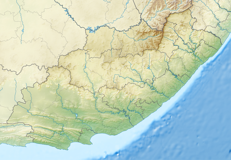
153:
Equirectangular projection, N/S stretching 117%. Geographic limits of the map:
1075:
149:
982:
1280:
1085:
902:
787:
700:
593:
553:
509:
418:
862:
717:
207:
1245:
912:
692:
662:
1305:
1095:
842:
827:
767:
1180:
1236:
Wikiproyecto:Ilustración/Taller de
Cartografía/Realizaciones/África
1055:
977:
619:
Click on a date/time to view the file as it appeared at that time.
1126:মডিউল:অবস্থান মানচিত্র/উপাত্ত/দক্ষিণ আফ্রিকা পূর্বাঞ্চলীয় কেপ/নথি
887:
699:{{Information |Description ={{en|1=Relief location map of the
1220:
1265:
1200:
1121:মডিউল:অবস্থান মানচিত্র/উপাত্ত/দক্ষিণ আফ্রিকা পূর্বাঞ্চলীয় কেপ
1050:
1335:
1325:
1241:
Plantilla:Mapa de localización de
Provincia Oriental del Cabo
1210:
1195:
1330:
1290:
1045:
87:(SVG file, nominally 1,298 × 902 pixels, file size: 2.29 MB)
1215:
1190:
1185:
1160:
1040:
1285:
177:
93:
1170:
1315:
1145:
351:
Add a one-line explanation of what this file represents
1175:
1155:
1023:
Module:Location map/data/South Africa
Eastern Cape/doc
711:
1031:
617:
560:
Creative
Commons Attribution-ShareAlike 3.0 Unported
534:
Creative
Commons Attribution-ShareAlike 3.0 Unported
117:
Commons is a freely licensed media file repository.
1226:Ŝablono:Situo sur mapo Sud-Afriko Orienta Kablando
1018:Module:Location map/data/South Africa Eastern Cape
399:https:\/\/commons.wikimedia.org\/wiki\/user:Htonl
138:South Africa Eastern Cape relief location map.svg
1151:Knowledge:Kartenwerkstatt/Positionskarten/Afrika
1136:Plantilya:Location map South Africa Eastern Cape
329:File:South Africa Eastern Cape location map.svg
190:File:South Africa Eastern Cape location map.svg
304:https://creativecommons.org/licenses/by-sa/3.0
98:
310:Creative Commons Attribution-Share Alike 3.0
234:
213:
173:
135:
1106:Шаблон:ПК Република Южна Африка Източен Кейп
324:
203:
183:
14:
1066:قالب:Location map South Africa Eastern Cape
270:– to copy, distribute and transmit the work
46:Size of this PNG preview of this SVG file:
1346:Berjocht:Posysjekaart Súd-Afrika East-Kaap
753:Chief Dawid Stuurman International Airport
1033:The following other wikis use this file:
471:https://commons.wikimedia.org/user:Htonl
1296:Parc national des Éléphants d'Addo
1271:Vorlage:Positionskarte Südafrika Ostkap
1166:Vorlage:Positionskarte Südafrika Ostkap
838:King William's Town Nature Reserve
1013:Module:Location map/data/Eastern Cape
129:
1301:Parc national des Zèbres de montagne
257:Attribution-Share Alike 3.0 Unported
1311:Modèle:Géolocalisation/Cap-Oriental
748:Buffalo Kloof Protected Environment
610:
245:
240:
13:
1363:
356:
350:
231:
227:
142:
130:
80:
1397:
1370:
853:Kwelera National Botanical Garden
355:
823:Inkwenkwezi Private Game Reserve
778:East London Coast Nature Reserve
712:
341:
281:Under the following conditions:
252:This file is licensed under the
244:
239:
233:
97:
31:
21:
1281:Col de Joubert (Afrique du Sud)
908:Nelson Mandela Bay Championship
813:Hole-in-the-Wall (Eastern Cape)
803:Great Fish River Nature Reserve
338:
143:
1028:
968:South African PGA Championship
614:
337:
26:
1:
1321:Grottes de la rivière Klasies
1003:Waters Meeting Nature Reserve
758:Commando Drift Nature Reserve
743:Bloukrans River (Grahamstown)
36:
988:Thomas Baines Nature Reserve
973:St. Croix Island (Algoa Bay)
878:Mountain Zebra National Park
818:Indalo Protected Environment
793:Fort Frederick, Eastern Cape
708:
363:Items portrayed in this file
7:
1360:
1262:Usage on frr.wikipedia.org
1132:Usage on ceb.wikipedia.org
1076:Taman Nasional Gunung Zébra
1072:Usage on ban.wikipedia.org
783:Entle Protected Environment
773:Double Mouth Nature Reserve
733:Blaauwkrantz Nature Reserve
148:Relief location map of the
10:
1402:
1342:Usage on fy.wikipedia.org
1277:Usage on fr.wikipedia.org
1252:Usage on fa.wikipedia.org
1232:Usage on es.wikipedia.org
1207:Usage on eo.wikipedia.org
1142:Usage on de.wikipedia.org
1117:Usage on bn.wikipedia.org
1082:Usage on bg.wikipedia.org
1062:Usage on ar.wikipedia.org
1037:Usage on af.wikipedia.org
763:Doddington (East Indiaman)
728:Ben Macdhui (Eastern Cape)
723:Baviaanskloof Mega Reserve
295:same or compatible license
132:
1306:Parc national de Camdeboo
933:Plettenberg Bay Aerodrome
611:
16:
923:Orange–Fish River Tunnel
868:Makana Botanical Gardens
340:
261:
104:This is a file from the
41:
1181:Bird Island (Algoa Bay)
998:Venpet–Venoil collision
993:Tsolwana Nature Reserve
698:
668:
176:
108:. Information from its
1246:Cuevas del río Klasies
1056:Port Elizabeth-lughawe
943:Quenera Nature Reserve
928:Oviston Nature Reserve
858:Kwelera Nature Reserve
848:Kragga Kamma Game Park
808:Hluleka Nature Reserve
111:description page there
1008:User:Xhantar/Sandbox2
963:South African Masters
958:Silaka Nature Reserve
953:Shamwari Game Reserve
898:Nahoon Nature Reserve
677:21:48, 4 January 2013
647:22:05, 4 January 2013
883:Mpofu Nature Reserve
70:2,560 × 1,779 pixels
1221:Universitato Rhodes
938:Port Alfred Airport
798:General Motors Open
669:Fix Lesotho masking
276:– to adapt the work
52:Other resolutions:
1291:Lundean's Nek
833:King Phalo Airport
449:Wikimedia username
436:author name string
391:Wikimedia username
383:author name string
74:1,298 × 902 pixels
66:1,280 × 889 pixels
62:1,024 × 712 pixels
1389:
1388:
1355:more global usage
1266:Uastkap (Prowins)
1201:St. Croix Islands
1051:Oos-Londenlughawe
1029:Global file usage
873:Melkhoutboom Cave
738:Blaauwkrantz Pass
706:
544:copyright license
530:copyright license
349:
334:
333:
222:
219:Reusing this file
126:
125:
106:Wikimedia Commons
32:Global file usage
1393:
1371:
1336:Van Stadens Pass
1326:Col de Buyspoort
1286:Qacha's Nek
1211:Orienta Kablando
1196:St. Croix Island
948:SDC Championship
918:Olifantskop Pass
689:
659:
621:
500:copyright status
486:copyright status
473:
468:
458:
453:
443:
440:
347:
317:
314:
311:
308:
305:
297:as the original.
254:Creative Commons
248:
247:
243:
242:
237:
236:
216:
179:
147:
139:
133:
122:
101:
100:
94:
88:
77:
58:640 × 445 pixels
54:320 × 222 pixels
48:800 × 556 pixels
1401:
1400:
1396:
1395:
1394:
1392:
1391:
1390:
1359:
1331:Col de Bidstone
1046:Mthatha-lughawe
1027:
893:Mthatha Airport
714:
707:
695:
687:
665:
657:
613:
612:
609:
608:
607:
606:
605:
604:
603:
602:
600:
590:
589:
588:
586:
571:
570:
569:
568:
567:
566:
565:
564:
562:
550:
549:
548:
546:
527:
526:
525:
524:
523:
522:
521:
520:
518:
506:
505:
504:
502:
483:
482:
481:
480:
479:
478:
477:
476:
475:
474:
469:
466:
460:
459:
454:
451:
445:
444:
441:
438:
429:
428:
427:
425:
415:
414:
413:
411:
376:
375:
374:
373:
372:
370:
354:
353:
352:
335:
320:
319:
318:
315:
312:
309:
306:
303:
302:
260:
249:
230:
229:
169:
137:
128:
127:
116:
115:
114:is shown below.
90:
86:
79:
78:
51:
12:
11:
5:
1399:
1387:
1386:
1383:
1379:
1378:
1375:
1362:
1357:of this file.
1351:
1350:
1349:
1348:
1340:
1339:
1338:
1333:
1328:
1323:
1318:
1313:
1308:
1303:
1298:
1293:
1288:
1283:
1275:
1274:
1273:
1268:
1260:
1259:
1258:
1250:
1249:
1248:
1243:
1238:
1230:
1229:
1228:
1223:
1218:
1216:Orient-Londono
1213:
1205:
1204:
1203:
1198:
1193:
1191:Jahleel Island
1188:
1186:Brenton Island
1183:
1178:
1173:
1168:
1163:
1161:Darlington Dam
1158:
1153:
1148:
1140:
1139:
1138:
1130:
1129:
1128:
1123:
1115:
1114:
1113:
1111:Източен Лондон
1108:
1103:
1098:
1093:
1088:
1080:
1079:
1078:
1070:
1069:
1068:
1060:
1059:
1058:
1053:
1048:
1043:
1041:Oceanos (skip)
1030:
1026:
1025:
1020:
1015:
1010:
1005:
1000:
995:
990:
985:
980:
975:
970:
965:
960:
955:
950:
945:
940:
935:
930:
925:
920:
915:
910:
905:
900:
895:
890:
885:
880:
875:
870:
865:
860:
855:
850:
845:
840:
835:
830:
825:
820:
815:
810:
805:
800:
795:
790:
785:
780:
775:
770:
765:
760:
755:
750:
745:
740:
735:
730:
725:
720:
710:
705:
704:
697:
693:
690:
684:
679:
674:
671:
670:
667:
663:
660:
654:
649:
644:
640:
639:
636:
633:
630:
627:
624:
616:
601:
599:4 January 2013
598:
596:
595:
594:
592:
591:
587:
582:
580:
579:
578:
577:
575:
563:
558:
556:
555:
554:
552:
551:
547:
542:
540:
539:
538:
537:
535:
531:
519:
514:
512:
511:
510:
508:
507:
503:
498:
496:
495:
494:
493:
491:
487:
462:
461:
447:
446:
434:
433:
432:
431:
430:
426:
423:
421:
420:
419:
417:
416:
412:
407:
405:
404:
403:
402:
400:
396:
392:
388:
384:
380:
371:
366:
364:
361:
360:
359:
358:
346:
345:
342:
339:
332:
331:
326:
325:Other versions
322:
321:
301:
300:
299:
298:
288:
279:
278:
277:
271:
264:You are free:
251:
250:
232:
226:
225:
223:
211:
210:
205:
201:
200:
199:
198:
195:
192:
185:
181:
180:
178:4 January 2013
175:
171:
170:
168:
167:
164:
161:
158:
140:
131:
124:
123:
102:
92:
91:
45:
40:
39:
34:
29:
24:
19:
9:
6:
4:
3:
2:
1398:
1384:
1381:
1380:
1376:
1373:
1372:
1369:
1366:
1358:
1356:
1347:
1344:
1343:
1341:
1337:
1334:
1332:
1329:
1327:
1324:
1322:
1319:
1317:
1314:
1312:
1309:
1307:
1304:
1302:
1299:
1297:
1294:
1292:
1289:
1287:
1284:
1282:
1279:
1278:
1276:
1272:
1269:
1267:
1264:
1263:
1261:
1257:
1254:
1253:
1251:
1247:
1244:
1242:
1239:
1237:
1234:
1233:
1231:
1227:
1224:
1222:
1219:
1217:
1214:
1212:
1209:
1208:
1206:
1202:
1199:
1197:
1194:
1192:
1189:
1187:
1184:
1182:
1179:
1177:
1174:
1172:
1169:
1167:
1164:
1162:
1159:
1157:
1154:
1152:
1149:
1147:
1144:
1143:
1141:
1137:
1134:
1133:
1131:
1127:
1124:
1122:
1119:
1118:
1116:
1112:
1109:
1107:
1104:
1102:
1099:
1097:
1094:
1092:
1091:Порт Елизабет
1089:
1087:
1084:
1083:
1081:
1077:
1074:
1073:
1071:
1067:
1064:
1063:
1061:
1057:
1054:
1052:
1049:
1047:
1044:
1042:
1039:
1038:
1036:
1035:
1034:
1024:
1021:
1019:
1016:
1014:
1011:
1009:
1006:
1004:
1001:
999:
996:
994:
991:
989:
986:
984:
983:Suurberg Pass
981:
979:
976:
974:
971:
969:
966:
964:
961:
959:
956:
954:
951:
949:
946:
944:
941:
939:
936:
934:
931:
929:
926:
924:
921:
919:
916:
914:
911:
909:
906:
904:
901:
899:
896:
894:
891:
889:
886:
884:
881:
879:
876:
874:
871:
869:
866:
864:
861:
859:
856:
854:
851:
849:
846:
844:
841:
839:
836:
834:
831:
829:
826:
824:
821:
819:
816:
814:
811:
809:
806:
804:
801:
799:
796:
794:
791:
789:
786:
784:
781:
779:
776:
774:
771:
769:
766:
764:
761:
759:
756:
754:
751:
749:
746:
744:
741:
739:
736:
734:
731:
729:
726:
724:
721:
719:
716:
715:
702:
696:
691:
685:
683:
680:
678:
675:
673:
672:
666:
661:
655:
653:
650:
648:
645:
642:
641:
637:
634:
631:
628:
625:
623:
622:
620:
597:
585:
581:
561:
557:
545:
541:
517:
513:
501:
497:
472:
465:
457:
450:
437:
422:
410:
406:
369:
365:
362:
343:
336:
330:
327:
323:
307:CC BY-SA 3.0
296:
292:
289:
286:
283:
282:
280:
275:
272:
269:
266:
265:
263:
262:
258:
255:
238:
224:
220:
215:
212:
209:
206:
202:
196:
193:
191:
188:
187:
186:
182:
172:
165:
162:
159:
156:
155:
154:
151:
146:
141:
134:
120:
113:
112:
107:
103:
96:
95:
89:
84:
83:Original file
75:
71:
67:
63:
59:
55:
49:
44:
38:
35:
33:
30:
28:
25:
23:
20:
18:
15:
1367:
1364:
1352:
1032:
903:Nahoon River
788:Formosa Peak
701:Eastern Cape
686:1,298 × 902
656:1,298 × 902
618:
615:File history
290:
284:
273:
267:
152:
150:Eastern Cape
144:
119:You can help
109:
81:
22:File history
1171:Ben Macdhui
863:MTS Oceanos
718:Africa Open
516:copyrighted
490:copyrighted
291:share alike
285:attribution
157:N: 29.75° S
136:Description
1316:Tiffindell
1146:Gariep Dam
913:Nqweba Dam
709:File usage
632:Dimensions
424:some value
214:Permission
166:E: 30.5° E
163:W: 22.5° E
160:S: 34.5° S
27:File usage
1176:Algoa Bay
1156:Ecca-Pass
843:Kouga Dam
828:Kat River
768:Doringnek
688:(2.29 MB)
658:(2.29 MB)
629:Thumbnail
626:Date/Time
584:inception
574:inception
145:English:
1361:Metadata
978:Suurberg
344:Captions
274:to remix
268:to share
259:license.
37:Metadata
1256:سد کوگا
1101:Ютънхах
888:Mthatha
643:current
638:Comment
409:creator
379:creator
368:depicts
348:English
85:
1382:Height
204:Author
197:ETOPO1
184:Source
1374:Width
1353:View
1086:Цгуну
694:Htonl
664:Htonl
456:Htonl
442:Htonl
387:Htonl
208:Htonl
1377:1298
1096:Бишо
635:User
316:true
313:true
194:SRTM
174:Date
17:File
1385:902
464:URL
395:URL
467::
452::
439::
72:|
68:|
64:|
60:|
56:|
50:.
221:)
217:(
121:.
76:.
