825:"}},"text\/plain":{"en":{"":"coordinates of the point of view"}}},"{\"value\":{\"latitude\":53.08033,\"longitude\":-3.056139,\"altitude\":null,\"precision\":1.0e-6,\"globe\":\"http:\\\/\\\/www.wikidata.org\\\/entity\\\/Q2\"},\"type\":\"globecoordinate\"}":{"text\/html":{"en":{"P1259":"53\u00b04'49.188"N, 3\u00b03'22.100"W"}},"text\/plain":{"en":{"P1259":"53\u00b04'49.188\"N, 3\u00b03'22.100\"W"}}},"{\"value\":{\"entity-type\":\"property\",\"numeric-id\":7787,\"id\":\"P7787\"},\"type\":\"wikibase-entityid\"}":{"text\/html":{"en":{"":"
893:"}},"text\/plain":{"en":{"":"coordinates of depicted place"}}},"{\"value\":{\"latitude\":53.08038,\"longitude\":-3.0561,\"altitude\":null,\"precision\":1.0e-5,\"globe\":\"http:\\\/\\\/www.wikidata.org\\\/entity\\\/Q2\"},\"type\":\"globecoordinate\"}":{"text\/html":{"en":{"P9149":"53\u00b04'49.37"N, 3\u00b03'21.96"W"}},"text\/plain":{"en":{"P9149":"53\u00b04'49.37\"N, 3\u00b03'21.96\"W"}}},"{\"value\":{\"entity-type\":\"property\",\"numeric-id\":7787,\"id\":\"P7787\"},\"type\":\"wikibase-entityid\"}":{"text\/html":{"en":{"":"
477:"}},"text\/plain":{"en":{"":"author name string"}}},"{\"value\":\"Ben Brooksbank\",\"type\":\"string\"}":{"text\/html":{"en":{"P2093":"Ben Brooksbank"}},"text\/plain":{"en":{"P2093":"Ben Brooksbank"}}},"{\"value\":{\"entity-type\":\"property\",\"numeric-id\":2699,\"id\":\"P2699\"},\"type\":\"wikibase-entityid\"}":{"text\/html":{"en":{"":"
668:"}},"text\/plain":{"en":{"":"inception"}}},"{\"value\":{\"time\":\"+1962-04-19T00:00:00Z\",\"timezone\":0,\"before\":0,\"after\":0,\"precision\":11,\"calendarmodel\":\"http:\\\/\\\/www.wikidata.org\\\/entity\\\/Q1985727\"},\"type\":\"time\"}":{"text\/html":{"en":{"P571":"19 April 1962"}},"text\/plain":{"en":{"P571":"19 April 1962"}}}}": -->
702:
270:
220:
262:
212:
889:
234:
305:
343:
348:
72:
485:"}},"text\/plain":{"en":{"P2699":"https:\/\/www.geograph.org.uk\/profile\/44502"}}},"{\"value\":{\"entity-type\":\"property\",\"numeric-id\":3831,\"id\":\"P3831\"},\"type\":\"wikibase-entityid\"}":{"text\/html":{"en":{"":"
1037:
710:"}},"text\/plain":{"en":{"P7482":"file available on the internet"}}},"{\"value\":{\"entity-type\":\"property\",\"numeric-id\":137,\"id\":\"P137\"},\"type\":\"wikibase-entityid\"}":{"text\/html":{"en":{"":"
718:"}},"text\/plain":{"en":{"P137":"Geograph Britain and Ireland"}}},"{\"value\":{\"entity-type\":\"property\",\"numeric-id\":7384,\"id\":\"P7384\"},\"type\":\"wikibase-entityid\"}":{"text\/html":{"en":{"":"
489:"}},"text\/plain":{"en":{"":"object of statement has role"}}},"{\"value\":{\"entity-type\":\"item\",\"numeric-id\":33231,\"id\":\"Q33231\"},\"type\":\"wikibase-entityid\"}":{"text\/html":{"en":{"P3831":"
961:"}},"text\/plain":{"en":{"":"media type"}}},"{\"value\":\"image\\\/jpeg\",\"type\":\"string\"}":{"text\/html":{"en":{"P1163":"image\/jpeg"}},"text\/plain":{"en":{"P1163":"image\/jpeg"}}}}": -->
624:"}},"text\/plain":{"en":{"":"copyright license"}}},"{\"value\":{\"entity-type\":\"item\",\"numeric-id\":19068220,\"id\":\"Q19068220\"},\"type\":\"wikibase-entityid\"}":{"text\/html":{"en":{"P275":"
580:"}},"text\/plain":{"en":{"":"copyright status"}}},"{\"value\":{\"entity-type\":\"item\",\"numeric-id\":50423863,\"id\":\"Q50423863\"},\"type\":\"wikibase-entityid\"}":{"text\/html":{"en":{"P6216":"
706:"}},"text\/plain":{"en":{"":"source of file"}}},"{\"value\":{\"entity-type\":\"item\",\"numeric-id\":74228490,\"id\":\"Q74228490\"},\"type\":\"wikibase-entityid\"}":{"text\/html":{"en":{"P7482":"
897:"}},"text\/plain":{"en":{"":"heading"}}},"{\"value\":{\"amount\":\"+112\",\"unit\":\"http:\\\/\\\/www.wikidata.org\\\/entity\\\/Q28390\"},\"type\":\"quantity\"}":{"text\/html":{"en":{"P7787":"112
829:"}},"text\/plain":{"en":{"":"heading"}}},"{\"value\":{\"amount\":\"+112\",\"unit\":\"http:\\\/\\\/www.wikidata.org\\\/entity\\\/Q28390\"},\"type\":\"quantity\"}":{"text\/html":{"en":{"P7787":"112
714:"}},"text\/plain":{"en":{"":"operator"}}},"{\"value\":{\"entity-type\":\"item\",\"numeric-id\":1503119,\"id\":\"Q1503119\"},\"type\":\"wikibase-entityid\"}":{"text\/html":{"en":{"P137":"
726:"}},"text\/plain":{"en":{"P7384":"1929001"}}},"{\"value\":{\"entity-type\":\"property\",\"numeric-id\":973,\"id\":\"P973\"},\"type\":\"wikibase-entityid\"}":{"text\/html":{"en":{"":"
473:"}},"text\/plain":{"en":{"":"creator"}}},"{\"value\":{\"entity-type\":\"property\",\"numeric-id\":2093,\"id\":\"P2093\"},\"type\":\"wikibase-entityid\"}":{"text\/html":{"en":{"":"
957:
730:"}},"text\/plain":{"en":{"":"described at URL"}}},"{\"value\":\"https:\\\/\\\/www.geograph.org.uk\\\/photo\\\/1929001\",\"type\":\"string\"}":{"text\/html":{"en":{"P973":"
253:
481:"}},"text\/plain":{"en":{"":"URL"}}},"{\"value\":\"https:\\\/\\\/www.geograph.org.uk\\\/profile\\\/44502\",\"type\":\"string\"}":{"text\/html":{"en":{"P2699":"
130:
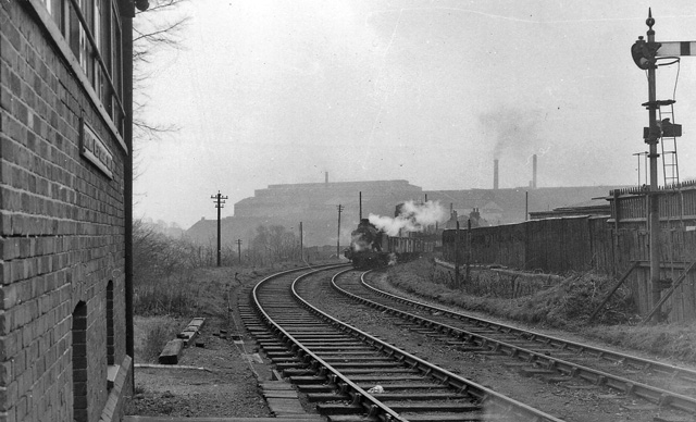
View SE, toward Brymbo and
Wrexham; ex-Great Western, Wrexham - Brymbo - Minera (Berwig Halt) line. The Halt closed when the passenger service ceased on 1/1/31, but the line remained open for goods until 1/10/82. A Down freight is approaching, headed by a 56XX 0-6-2T; beyond is Brymbo
722:"}},"text\/plain":{"en":{"":"geograph.org.uk image ID"}}},"{\"value\":\"1929001\",\"type\":\"string\"}":{"text\/html":{"en":{"P7384":"
1054:== {{int:filedesc}} == {{Information |Description={{en|1=Site of Brymbo West Crossing Halt, near to Brymbo, Wrexham/Wrecsam, Great Britain. View SE, toward Brymbo and Wrexham; ex-Great Western, Wrexham - Brymbo - Minera (Berwig Halt) line. The Halt closed
203:
395:– You must give appropriate credit, provide a link to the license, and indicate if changes were made. You may do so in any reasonable manner, but not in any way that suggests the licensor endorses you or your use.
83:
217:
51:
267:
1047:
723:
707:
625:
581:
715:
490:
958:
894:
890:
826:
822:
719:
703:
577:
486:
478:
474:
731:
482:
727:
711:
665:
621:
470:
155:
628:"}},"text\/plain":{"en":{"P275":"Creative Commons Attribution-ShareAlike 2.0 Generic"}}}}": -->
181:
734:"}},"text\/plain":{"en":{"P973":"https:\/\/www.geograph.org.uk\/photo\/1929001"}}}}": -->
1073:
1036:
1031:
42:
757:
651:
607:
277:
227:
777:
312:
1114:
This file contains additional information, probably added from the digital camera or scanner used to create or digitize it.
1158:
402:
562:
968:
935:
908:
867:
840:
785:
741:
591:
555:
540:
527:
800:
770:
675:
635:
500:
459:
358:
1117:
If the file has been modified from its original state, some details may not fully reflect the modified file.
1078:
401:– If you remix, transform, or build upon the material, you must distribute your contributions under the
319:
on the
Geograph website for the photographer's contact details. The copyright on this image is owned by
1083:
493:"}},"text\/plain":{"en":{"P3831":"photographer"}}}}": -->
584:"}},"text\/plain":{"en":{"P6216":"copyrighted"}}}}": -->
1064:
The following pages on the
English Knowledge use this file (pages on other projects are not listed):
901:"}},"text\/plain":{"en":{"P7787":"112 degree"}}}}": -->
833:"}},"text\/plain":{"en":{"P7787":"112 degree"}}}}": -->
91:
807:
792:
547:
355:
8:
299:
283:
233:
1068:
324:
78:
449:
127:
Site of Brymbo West
Crossing Halt, near to Brymbo, Wrexham/Wrecsam, Great Britain.
170:
151:
978:
918:
850:
751:
685:
645:
601:
510:
1173:
304:
316:
1004:
Click on a date/time to view the file as it appeared at that time.
116:
Site of Brymbo West
Crossing Halt - geograph.org.uk - 1929001.jpg
52:
Site_of_Brymbo_West_Crossing_Halt_-_geograph.org.uk_-_1929001.jpg
269:
219:
159:
204:
53° 04′ 49.19″ N, 3° 03′ 22.1″ W
254:
53° 04′ 49″ N, 3° 03′ 22″ W
140:
66:
443:
Add a one-line explanation of what this file represents
1101:
1062:
1092:
1002:
188:
Creative
Commons Attribution Share-alike license 2.0
90:
Commons is a freely licensed media file repository.
652:
Creative
Commons Attribution-ShareAlike 2.0 Generic
626:
Creative
Commons Attribution-ShareAlike 2.0 Generic
56:(640 × 388 pixels, file size: 112 KB, MIME type:
412:https://creativecommons.org/licenses/by-sa/2.0
71:
732:https:\/\/www.geograph.org.uk\/photo\/1929001
483:https:\/\/www.geograph.org.uk\/profile\/44502
418:Creative Commons Attribution-Share Alike 2.0
336:
176:
136:
113:
166:
146:
14:
898:
830:
378:– to copy, distribute and transmit the work
1094:The following other wikis use this file:
1074:Brymbo West Crossing Halt railway station
808:https://www.geograph.org.uk/photo/1929001
548:https://www.geograph.org.uk/profile/44502
276:View this and other nearby images on:
226:View this and other nearby images on:
102:
1159:Adobe Photoshop Elements 3.0 Windows
323:and is licensed for reuse under the
244:
194:
995:
359:Attribution-Share Alike 2.0 Generic
347:
342:
327:Attribution-ShareAlike 2.0 license.
13:
1112:
448:
442:
333:
310:
120:
103:
49:
1190:
1119:
447:
1063:
841:coordinates of the point of view
823:coordinates of the point of view
433:
389:Under the following conditions:
354:This file is licensed under the
346:
341:
335:
303:
282:
268:
260:
232:
218:
210:
70:
31:
21:
1049:File Upload Bot (Magnus Manske)
430:
121:
46:No higher resolution available.
1089:
999:
758:file available on the internet
708:file available on the internet
429:
311:This image was taken from the
26:
1:
909:coordinates of depicted place
891:coordinates of depicted place
36:
1059:
778:Geograph Britain and Ireland
716:Geograph Britain and Ireland
556:object of statement has role
487:object of statement has role
455:Items portrayed in this file
295:
259:
209:
7:
1109:
1079:Brymbo railway branch lines
856:53°4'49.188"N, 3°3'22.100"W
10:
1195:
1098:Usage on www.wikidata.org
1084:Wrexham and Minera Railway
403:same or compatible license
110:
105:
1165:File change date and time
996:
924:53°4'49.37"N, 3°3'21.96"W
16:
1032:11:49, 22 September 2010
786:geograph.org.uk image ID
720:geograph.org.uk image ID
432:
369:
77:This is a file from the
41:
1053:
139:
81:. Information from its
317:this photograph's page
288:53.080380; -3.056100
238:53.080330; -3.056139
84:description page there
1139:Horizontal resolution
160:geograph_org2commons
1168:23:17, 22 June 2010
1147:Vertical resolution
1126:EPSON scanner image
384:– to adapt the work
528:author name string
475:author name string
1182:
1181:
1090:Global file usage
1069:Brymbo Steelworks
1057:
900:
832:
636:copyright license
622:copyright license
441:
332:
331:
315:collection. See
293:
292:
243:
242:
192:
191:
185:
182:Reusing this file
154:; transferred by
99:
98:
79:Wikimedia Commons
32:Global file usage
1186:
1120:
1044:
1006:
946:
945:
940:
878:
877:
872:
810:
805:
801:described at URL
795:
790:
780:
775:
728:described at URL
592:copyright status
578:copyright status
565:
560:
550:
545:
535:
532:
439:
425:
422:
419:
416:
413:
405:as the original.
367:
356:Creative Commons
350:
349:
345:
344:
339:
338:
325:Creative Commons
313:Geograph project
307:
300:
289:
286:
272:
271:
265:
264:
263:
257:
256:
245:
239:
236:
222:
221:
215:
214:
213:
207:
206:
195:
179:
142:
125:
117:
111:
95:
74:
73:
67:
61:
59:
1194:
1193:
1189:
1188:
1187:
1185:
1184:
1183:
1108:
1088:
1065:
1058:
1050:
1042:
998:
997:
994:
993:
992:
991:
990:
989:
988:
987:
985:
975:
974:
973:
971:
956:
955:
954:
953:
952:
951:
950:
949:
948:
947:
943:
941:
938:
929:
928:
927:
925:
915:
914:
913:
911:
888:
887:
886:
885:
884:
883:
882:
881:
880:
879:
875:
873:
870:
861:
860:
859:
857:
847:
846:
845:
843:
820:
819:
818:
817:
816:
815:
814:
813:
812:
811:
806:
803:
797:
796:
791:
788:
782:
781:
776:
773:
764:
763:
762:
760:
748:
747:
746:
744:
701:
700:
699:
698:
697:
696:
695:
694:
692:
682:
681:
680:
678:
663:
662:
661:
660:
659:
658:
657:
656:
654:
642:
641:
640:
638:
619:
618:
617:
616:
615:
614:
613:
612:
610:
598:
597:
596:
594:
575:
574:
573:
572:
571:
570:
569:
568:
567:
566:
561:
558:
552:
551:
546:
543:
537:
536:
533:
530:
521:
520:
519:
517:
507:
506:
505:
503:
468:
467:
466:
465:
464:
462:
446:
445:
444:
427:
426:
423:
420:
417:
414:
411:
410:
368:
365:
362:
351:
328:
298:
287:
261:
252:
251:
248:Object location
237:
211:
202:
201:
198:Camera location
193:
152:geograph.org.uk
132:
115:
108:
101:
100:
89:
88:
87:is shown below.
63:
57:
55:
48:
47:
12:
11:
5:
1192:
1180:
1179:
1176:
1170:
1169:
1166:
1162:
1161:
1156:
1152:
1151:
1148:
1144:
1143:
1140:
1136:
1135:
1132:
1128:
1127:
1124:
1111:
1107:
1106:
1105:
1104:
1091:
1087:
1086:
1081:
1076:
1071:
1061:
1056:
1055:
1052:
1048:
1045:
1039:
1034:
1029:
1025:
1024:
1021:
1018:
1015:
1012:
1009:
1001:
986:
983:
981:
980:
979:
977:
976:
972:
967:
965:
964:
963:
962:
960:
934:
933:
932:
931:
930:
926:
923:
921:
920:
919:
917:
916:
912:
907:
905:
904:
903:
902:
896:
892:
866:
865:
864:
863:
862:
858:
855:
853:
852:
851:
849:
848:
844:
839:
837:
836:
835:
834:
828:
824:
799:
798:
784:
783:
769:
768:
767:
766:
765:
761:
756:
754:
753:
752:
750:
749:
745:
742:source of file
740:
738:
737:
736:
735:
733:
729:
725:
721:
717:
713:
709:
705:
704:source of file
693:
690:
688:
687:
686:
684:
683:
679:
674:
672:
671:
670:
669:
667:
655:
650:
648:
647:
646:
644:
643:
639:
634:
632:
631:
630:
629:
627:
623:
611:
606:
604:
603:
602:
600:
599:
595:
590:
588:
587:
586:
585:
583:
579:
554:
553:
539:
538:
534:Ben Brooksbank
526:
525:
524:
523:
522:
518:
515:
513:
512:
511:
509:
508:
504:
499:
497:
496:
495:
494:
492:
488:
484:
480:
476:
472:
463:
458:
456:
453:
452:
451:
450:
438:
437:
434:
431:
409:
408:
407:
406:
396:
387:
386:
385:
379:
372:You are free:
366:Ben Brooksbank
363:
353:
352:
334:
330:
329:
321:Ben Brooksbank
308:
297:
294:
291:
290:
280:
274:
249:
241:
240:
230:
224:
199:
190:
189:
186:
174:
173:
171:Ben Brooksbank
168:
164:
163:
148:
144:
143:
138:
134:
133:
118:
109:
107:
104:
97:
96:
75:
65:
64:
45:
40:
39:
34:
29:
24:
19:
9:
6:
4:
3:
2:
1191:
1177:
1175:
1172:
1171:
1167:
1164:
1163:
1160:
1157:
1155:Software used
1154:
1153:
1149:
1146:
1145:
1141:
1138:
1137:
1133:
1130:
1129:
1125:
1122:
1121:
1118:
1115:
1103:
1100:
1099:
1097:
1096:
1095:
1085:
1082:
1080:
1077:
1075:
1072:
1070:
1067:
1066:
1051:
1046:
1040:
1038:
1035:
1033:
1030:
1027:
1026:
1022:
1019:
1016:
1013:
1010:
1008:
1007:
1005:
982:
970:
966:
937:
922:
910:
906:
869:
854:
842:
838:
809:
802:
794:
787:
779:
772:
759:
755:
743:
739:
691:19 April 1962
689:
677:
673:
653:
649:
637:
633:
609:
605:
593:
589:
564:
557:
549:
542:
529:
514:
502:
498:
461:
457:
454:
435:
428:
415:CC BY-SA 2.0
404:
400:
397:
394:
391:
390:
388:
383:
380:
377:
374:
373:
371:
370:
364:Attribution:
360:
357:
340:
326:
322:
318:
314:
309:
306:
302:
301:
285:
281:
279:
278:OpenStreetMap
275:
273:
255:
250:
247:
246:
235:
231:
229:
228:OpenStreetMap
225:
223:
205:
200:
197:
196:
187:
183:
178:
175:
172:
169:
165:
161:
157:
153:
149:
145:
141:19 April 1962
135:
129:
128:
124:
119:
112:
93:
86:
85:
80:
76:
69:
68:
62:
53:
44:
38:
35:
33:
30:
28:
25:
23:
20:
18:
15:
1178:Uncalibrated
1116:
1113:
1093:
1003:
1000:File history
563:photographer
491:photographer
398:
392:
381:
375:
320:
258:
208:
156:User:svejk74
126:
122:
92:You can help
82:
50:
22:File history
1174:Color space
1131:Orientation
1123:Image title
608:copyrighted
582:copyrighted
399:share alike
393:attribution
131:Steelworks.
114:Description
1060:File usage
1041:640 × 388
1017:Dimensions
984:image/jpeg
969:media type
959:media type
516:some value
177:Permission
58:image/jpeg
27:File usage
1014:Thumbnail
1011:Date/Time
676:inception
666:inception
296:Licensing
123:English:
1110:Metadata
1102:Q2927199
1043:(112 KB)
771:operator
712:operator
436:Captions
382:to remix
376:to share
361:license.
37:Metadata
1028:current
1023:Comment
936:heading
895:heading
868:heading
827:heading
793:1929001
724:1929001
501:creator
471:creator
460:depicts
440:English
106:Summary
54:
1150:78 dpc
1142:78 dpc
1134:Normal
944:degree
899:degree
876:degree
831:degree
266:
216:
167:Author
158:using
147:Source
150:From
1020:User
942:112
874:112
424:true
421:true
137:Date
17:File
541:URL
479:URL
939::
871::
804::
789::
774::
559::
544::
531::
184:)
180:(
162:.
94:.
60:)
Text is available under the Creative Commons Attribution-ShareAlike License. Additional terms may apply.
_region:GB-GBN_heading:112.00&language=en)
