548:"}},"text\/plain":{"en":{"":"coordinates of the point of view"}}},"{\"value\":{\"latitude\":53.38747,\"longitude\":-1.4577,\"altitude\":null,\"precision\":1.0e-5,\"globe\":\"http:\\\/\\\/www.wikidata.org\\\/entity\\\/Q2\"},\"type\":\"globecoordinate\"}":{"text\/html":{"en":{"P1259":"53\u00b023'14.89"N, 1\u00b027'27.72"W"}},"text\/plain":{"en":{"P1259":"53\u00b023'14.89\"N, 1\u00b027'27.72\"W"}}},"{\"value\":{\"entity-type\":\"property\",\"numeric-id\":7787,\"id\":\"P7787\"},\"type\":\"wikibase-entityid\"}":{"text\/html":{"en":{"":"
654:"}},"text\/plain":{"en":{"":"coordinates of depicted place"}}},"{\"value\":{\"latitude\":53.38747,\"longitude\":-1.4577,\"altitude\":null,\"precision\":1.0e-5,\"globe\":\"http:\\\/\\\/www.wikidata.org\\\/entity\\\/Q2\"},\"type\":\"globecoordinate\"}":{"text\/html":{"en":{"P9149":"53\u00b023'14.89"N, 1\u00b027'27.72"W"}},"text\/plain":{"en":{"P9149":"53\u00b023'14.89\"N, 1\u00b027'27.72\"W"}}},"{\"value\":{\"entity-type\":\"property\",\"numeric-id\":7787,\"id\":\"P7787\"},\"type\":\"wikibase-entityid\"}":{"text\/html":{"en":{"":"
616:"}},"text\/plain":{"en":{"":"inception"}}},"{\"value\":{\"time\":\"+1957-06-17T00:00:00Z\",\"timezone\":0,\"before\":0,\"after\":0,\"precision\":11,\"calendarmodel\":\"http:\\\/\\\/www.wikidata.org\\\/entity\\\/Q1985727\"},\"type\":\"time\"}":{"text\/html":{"en":{"P571":"17 June 1957"}},"text\/plain":{"en":{"P571":"17 June 1957"}}}}": -->
219:
391:
341:
650:
333:
405:
355:
187:
225:
230:
141:
then on from
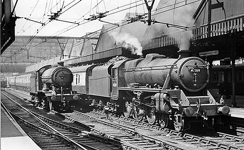
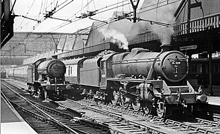
Sheffield to London Marylebone via Nottingham Victoria and Leicester Central. The express seen here, headed by Stanier Class 5 4-6-0 No. 45219, is NOT - however - the 'South Yorkshireman', but the 13.55 to Leicester Central, which had originated at Manchester London Road at 12.40, hauled by an electric locomotive. On the Through line is Class J39 0-6-0 No. 64753, and an electric locomotive is just in view behind.
91:
43:
504:"}},"text\/plain":{"en":{"":"copyright license"}}},"{\"value\":{\"entity-type\":\"item\",\"numeric-id\":19068220,\"id\":\"Q19068220\"},\"type\":\"wikibase-entityid\"}":{"text\/html":{"en":{"P275":"
460:"}},"text\/plain":{"en":{"":"copyright status"}}},"{\"value\":{\"entity-type\":\"item\",\"numeric-id\":50423863,\"id\":\"Q50423863\"},\"type\":\"wikibase-entityid\"}":{"text\/html":{"en":{"P6216":"
552:"}},"text\/plain":{"en":{"":"heading"}}},"{\"value\":{\"amount\":\"+315.0\",\"unit\":\"http:\\\/\\\/www.wikidata.org\\\/entity\\\/Q28390\"},\"type\":\"quantity\"}":{"text\/html":{"en":{"P7787":"315.0
658:"}},"text\/plain":{"en":{"":"heading"}}},"{\"value\":{\"amount\":\"+315\",\"unit\":\"http:\\\/\\\/www.wikidata.org\\\/entity\\\/Q28390\"},\"type\":\"quantity\"}":{"text\/html":{"en":{"P7787":"315
456:
140:
View NW, towards
Penistone and Manchester (London Road); ex-Great Central Manchester - Sheffield main line. The route had been electrified since June 1954, but was still traversed from Penistone by the steam-hauled 'South Yorkshireman', which ran from Bradford (Exchange), Halifax and Huddersfield,
777:{{Information |Description= Sheffield Victoria Station, with train View NW, towards Penistone and Manchester (London Road); ex-Great Central Manchester - Sheffield main line. The route had been electrified since June 1954, but was still traversed from Pen
374:
324:
277:– You must give appropriate credit, provide a link to the license, and indicate if changes were made. You may do so in any reasonable manner, but not in any way that suggests the licensor endorses you or your use.
388:
338:
505:
461:
655:
651:
549:
545:
457:
613:
501:
809:
508:"}},"text\/plain":{"en":{"P275":"Creative Commons Attribution-ShareAlike 2.0 Generic"}}}}": -->
57:
53:
47:
102:
174:
70:
531:
487:
398:
348:
194:
832:
This file contains additional information, probably added from the digital camera or scanner used to create or digitize it.
284:
696:
669:
590:
563:
471:
791:
623:
515:
446:
240:
835:
If the file has been modified from its original state, some details may not fully reflect the modified file.
283:– If you remix, transform, or build upon the material, you must distribute your contributions under the
201:
on the
Geograph website for the photographer's contact details. The copyright on this image is owned by
556:"}},"text\/plain":{"en":{"P7787":"315.0 degree"}}}}": -->
464:"}},"text\/plain":{"en":{"P6216":"copyrighted"}}}}": -->
787:
The following pages on the
English Knowledge use this file (pages on other projects are not listed):
662:"}},"text\/plain":{"en":{"P7787":"315 degree"}}}}": -->
110:
759:
754:
61:
42:
237:
8:
181:
404:
354:
206:
97:
436:
770:
679:
633:
573:
525:
481:
891:
186:
876:
198:
727:
Click on a date/time to view the file as it appeared at that time.
390:
340:
375:
53° 23′ 15″ N, 1° 27′ 28″ W
325:
53° 23′ 15″ N, 1° 27′ 28″ W
85:
430:
Add a one-line explanation of what this file represents
819:
785:
800:
725:
109:
Commons is a freely licensed media file repository.
532:
Creative
Commons Attribution-ShareAlike 2.0 Generic
506:
Creative
Commons Attribution-ShareAlike 2.0 Generic
75:(1,000 × 614 pixels, file size: 240 KB, MIME type:
294:https://creativecommons.org/licenses/by-sa/2.0
90:
300:Creative Commons Attribution-Share Alike 2.0
218:
169:
145:
127:
161:
153:
14:
659:
553:
260:– to copy, distribute and transmit the work
802:The following other wikis use this file:
136:Sheffield Victoria Station, with train.
397:View this and other nearby images on:
347:View this and other nearby images on:
121:
365:
315:
205:and is licensed for reuse under the
718:
241:Attribution-Share Alike 2.0 Generic
229:
224:
209:Attribution-ShareAlike 2.0 license.
13:
830:
792:Sheffield Victoria railway station
435:
429:
215:
192:
122:
68:
908:
837:
434:
786:
564:coordinates of the point of view
546:coordinates of the point of view
420:
403:
389:
381:
353:
339:
331:
271:Under the following conditions:
236:This file is licensed under the
228:
223:
217:
185:
89:
31:
21:
417:
797:
722:
416:
193:This image was taken from the
130:Sheffield Victoria 2061975.jpg
26:
1:
670:coordinates of depicted place
652:coordinates of depicted place
36:
782:
442:Items portrayed in this file
380:
330:
7:
827:
806:Usage on arz.wikipedia.org
685:53°23'14.89"N, 1°27'27.72"W
579:53°23'14.89"N, 1°27'27.72"W
10:
913:
816:Usage on www.wikidata.org
285:same or compatible license
149:Taken on 17 June 1957
124:
883:File change date and time
719:
16:
419:
251:
96:This is a file from the
41:
776:
148:
100:. Information from its
409:53.387470; -1.457700
359:53.387470; -1.457700
199:this photograph's page
103:description page there
46:Size of this preview:
886:18:09, 8 October 2010
857:Horizontal resolution
755:19:15, 8 October 2010
810:محطة شيفيلد ڤيكتوريا
865:Vertical resolution
844:EPSON scanner image
266:– to adapt the work
52:Other resolutions:
62:1,000 × 614 pixels
900:
899:
798:Global file usage
780:
661:
555:
516:copyright license
502:copyright license
428:
414:
413:
364:
363:
313:
312:
214:
213:
197:collection. See
178:
175:Reusing this file
118:
117:
98:Wikimedia Commons
32:Global file usage
904:
838:
767:
729:
707:
706:
701:
601:
600:
595:
472:copyright status
458:copyright status
426:
410:
407:
393:
392:
386:
385:
384:
378:
377:
366:
360:
357:
343:
342:
336:
335:
334:
328:
327:
316:
307:
304:
301:
298:
295:
287:as the original.
249:
238:Creative Commons
232:
231:
227:
226:
221:
220:
207:Creative Commons
195:Geograph project
189:
182:
172:
157:Geograph Project
131:
125:
114:
93:
92:
86:
80:
78:
65:
58:640 × 393 pixels
54:320 × 196 pixels
48:800 × 491 pixels
912:
911:
907:
906:
905:
903:
902:
901:
826:
796:
788:
781:
773:
765:
721:
720:
717:
716:
715:
714:
713:
712:
711:
710:
709:
708:
704:
702:
699:
690:
689:
688:
686:
676:
675:
674:
672:
649:
648:
647:
646:
645:
644:
643:
642:
640:
630:
629:
628:
626:
611:
610:
609:
608:
607:
606:
605:
604:
603:
602:
598:
596:
593:
584:
583:
582:
580:
570:
569:
568:
566:
543:
542:
541:
540:
539:
538:
537:
536:
534:
522:
521:
520:
518:
499:
498:
497:
496:
495:
494:
493:
492:
490:
478:
477:
476:
474:
455:
454:
453:
452:
451:
449:
433:
432:
431:
408:
382:
373:
372:
369:Object location
358:
332:
323:
322:
319:Camera location
314:
309:
308:
305:
302:
299:
296:
293:
292:
250:
247:
244:
233:
210:
129:
120:
119:
108:
107:
106:is shown below.
82:
76:
74:
67:
66:
51:
12:
11:
5:
910:
898:
897:
894:
888:
887:
884:
880:
879:
874:
870:
869:
866:
862:
861:
858:
854:
853:
850:
846:
845:
842:
829:
825:
824:
823:
822:
814:
813:
812:
799:
795:
794:
784:
779:
778:
775:
771:
768:
762:
757:
752:
748:
747:
744:
741:
738:
735:
732:
724:
695:
694:
693:
692:
691:
687:
684:
682:
681:
680:
678:
677:
673:
668:
666:
665:
664:
663:
657:
653:
641:
638:
636:
635:
634:
632:
631:
627:
622:
620:
619:
618:
617:
615:
589:
588:
587:
586:
585:
581:
578:
576:
575:
574:
572:
571:
567:
562:
560:
559:
558:
557:
551:
547:
535:
530:
528:
527:
526:
524:
523:
519:
514:
512:
511:
510:
509:
507:
503:
491:
486:
484:
483:
482:
480:
479:
475:
470:
468:
467:
466:
465:
463:
459:
450:
445:
443:
440:
439:
438:
437:
425:
424:
421:
418:
412:
411:
401:
395:
370:
362:
361:
351:
345:
320:
311:
310:
291:
290:
289:
288:
278:
269:
268:
267:
261:
254:You are free:
248:Ben Brooksbank
245:
235:
234:
216:
212:
211:
203:Ben Brooksbank
190:
179:
167:
166:
165:Ben Brooksbank
163:
159:
158:
155:
151:
150:
147:
143:
142:
132:
123:
116:
115:
94:
84:
83:
45:
40:
39:
34:
29:
24:
19:
9:
6:
4:
3:
2:
909:
895:
893:
890:
889:
885:
882:
881:
878:
875:
873:Software used
872:
871:
867:
864:
863:
859:
856:
855:
851:
848:
847:
843:
840:
839:
836:
833:
821:
818:
817:
815:
811:
808:
807:
805:
804:
803:
793:
790:
789:
774:
769:
763:
761:
758:
756:
753:
750:
749:
745:
742:
739:
736:
733:
731:
730:
728:
698:
683:
671:
667:
637:
625:
621:
592:
577:
565:
561:
533:
529:
517:
513:
489:
485:
473:
469:
448:
444:
441:
422:
415:
406:
402:
400:
399:OpenStreetMap
396:
394:
376:
371:
368:
367:
356:
352:
350:
349:OpenStreetMap
346:
344:
326:
321:
318:
317:
297:CC BY-SA 2.0
286:
282:
279:
276:
273:
272:
270:
265:
262:
259:
256:
255:
253:
252:
246:Attribution:
242:
239:
222:
208:
204:
200:
196:
191:
188:
184:
183:
180:
176:
171:
168:
164:
160:
156:
152:
144:
139:
138:
137:
133:
126:
112:
105:
104:
99:
95:
88:
87:
81:
72:
71:Original file
63:
59:
55:
49:
44:
38:
35:
33:
30:
28:
25:
23:
20:
18:
15:
896:Uncalibrated
834:
831:
801:
764:1,000 × 614
726:
723:File history
639:17 June 1957
379:
329:
280:
274:
263:
257:
202:
135:
134:
111:You can help
101:
69:
22:File history
892:Color space
849:Orientation
841:Image title
488:copyrighted
462:copyrighted
281:share alike
275:attribution
128:Description
877:GIMP 2.6.8
783:File usage
740:Dimensions
170:Permission
77:image/jpeg
27:File usage
737:Thumbnail
734:Date/Time
624:inception
614:inception
828:Metadata
820:Q7492778
766:(240 KB)
423:Captions
264:to remix
258:to share
243:license.
37:Metadata
868:200 dpi
860:200 dpi
772:G-13114
751:current
746:Comment
697:heading
656:heading
591:heading
550:heading
447:depicts
427:English
73:
852:Normal
705:degree
660:degree
599:degree
597:315.0
554:degree
387:
337:
162:Author
154:Source
743:User
703:315
306:true
303:true
146:Date
17:File
700::
594::
60:|
56:|
50:.
177:)
173:(
113:.
79:)
64:.
Text is available under the Creative Commons Attribution-ShareAlike License. Additional terms may apply.


_heading:315.00&language=en)
_heading:315.00&language=en)