822:"}},"text\/plain":{"en":{"":"coordinates of depicted place"}}},"{\"value\":{\"latitude\":55.8286,\"longitude\":-4.287,\"altitude\":null,\"precision\":0.0001,\"globe\":\"http:\\\/\\\/www.wikidata.org\\\/entity\\\/Q2\"},\"type\":\"globecoordinate\"}":{"text\/html":{"en":{"P9149":"55\u00b049'43.0"N, 4\u00b017'13.2"W"}},"text\/plain":{"en":{"P9149":"55\u00b049'43.0\"N, 4\u00b017'13.2\"W"}}}}": -->
438:"}},"text\/plain":{"en":{"":"author name string"}}},"{\"value\":\"s allison\",\"type\":\"string\"}":{"text\/html":{"en":{"P2093":"s allison"}},"text\/plain":{"en":{"P2093":"s allison"}}},"{\"value\":{\"entity-type\":\"property\",\"numeric-id\":2699,\"id\":\"P2699\"},\"type\":\"wikibase-entityid\"}":{"text\/html":{"en":{"":"
740:"}},"text\/plain":{"en":{"":"inception"}}},"{\"value\":{\"time\":\"+2005-08-05T00:00:00Z\",\"timezone\":0,\"before\":0,\"after\":0,\"precision\":11,\"calendarmodel\":\"http:\\\/\\\/www.wikidata.org\\\/entity\\\/Q1985727\"},\"type\":\"time\"}":{"text\/html":{"en":{"P571":"5 August 2005"}},"text\/plain":{"en":{"P571":"5 August 2005"}}}}": -->
617:
422:
237:
258:
296:
301:
72:
905:"}},"text\/plain":{"en":{"":"f-number"}}},"{\"value\":{\"amount\":\"+5\",\"unit\":\"1\"},\"type\":\"quantity\"}":{"text\/html":{"en":{"P6790":"5"}},"text\/plain":{"en":{"P6790":"5"}}}}": -->
625:"}},"text\/plain":{"en":{"P7482":"file available on the internet"}}},"{\"value\":{\"entity-type\":\"property\",\"numeric-id\":7384,\"id\":\"P7384\"},\"type\":\"wikibase-entityid\"}":{"text\/html":{"en":{"":"
430:"}},"text\/plain":{"en":{"":"object of statement has role"}}},"{\"value\":{\"entity-type\":\"item\",\"numeric-id\":33231,\"id\":\"Q33231\"},\"type\":\"wikibase-entityid\"}":{"text\/html":{"en":{"P3831":"
943:"}},"text\/plain":{"en":{"":"focal length"}}},"{\"value\":{\"amount\":\"+17.46875\",\"unit\":\"http:\\\/\\\/www.wikidata.org\\\/entity\\\/Q174789\"},\"type\":\"quantity\"}":{"text\/html":{"en":{"P2151":"17.46875
641:"}},"text\/plain":{"en":{"P137":"Geograph Britain and Ireland"}}},"{\"value\":{\"entity-type\":\"property\",\"numeric-id\":973,\"id\":\"P973\"},\"type\":\"wikibase-entityid\"}":{"text\/html":{"en":{"":"
988:"}},"text\/plain":{"en":{"":"media type"}}},"{\"value\":\"image\\\/jpeg\",\"type\":\"string\"}":{"text\/html":{"en":{"P1163":"image\/jpeg"}},"text\/plain":{"en":{"P1163":"image\/jpeg"}}}}": -->
577:"}},"text\/plain":{"en":{"":"copyright license"}}},"{\"value\":{\"entity-type\":\"item\",\"numeric-id\":19068220,\"id\":\"Q19068220\"},\"type\":\"wikibase-entityid\"}":{"text\/html":{"en":{"P275":"
533:"}},"text\/plain":{"en":{"":"copyright status"}}},"{\"value\":{\"entity-type\":\"item\",\"numeric-id\":50423863,\"id\":\"Q50423863\"},\"type\":\"wikibase-entityid\"}":{"text\/html":{"en":{"P6216":"
860:"}},"text\/plain":{"en":{"":"exposure time"}}},"{\"value\":{\"amount\":\"+0.008\",\"unit\":\"http:\\\/\\\/www.wikidata.org\\\/entity\\\/Q11574\"},\"type\":\"quantity\"}":{"text\/html":{"en":{"P6757":"0.008
621:"}},"text\/plain":{"en":{"":"source of file"}}},"{\"value\":{\"entity-type\":\"item\",\"numeric-id\":74228490,\"id\":\"Q74228490\"},\"type\":\"wikibase-entityid\"}":{"text\/html":{"en":{"P7482":"
778:"}},"text\/plain":{"en":{"":"captured with"}}},"{\"value\":{\"entity-type\":\"item\",\"numeric-id\":10887031,\"id\":\"Q10887031\"},\"type\":\"wikibase-entityid\"}":{"text\/html":{"en":{"P4082":"
434:"}},"text\/plain":{"en":{"P3831":"photographer"}}},"{\"value\":{\"entity-type\":\"property\",\"numeric-id\":2093,\"id\":\"P2093\"},\"type\":\"wikibase-entityid\"}":{"text\/html":{"en":{"":"
637:"}},"text\/plain":{"en":{"":"operator"}}},"{\"value\":{\"entity-type\":\"item\",\"numeric-id\":1503119,\"id\":\"Q1503119\"},\"type\":\"wikibase-entityid\"}":{"text\/html":{"en":{"P137":"
633:"}},"text\/plain":{"en":{"P7384":"34877"}}},"{\"value\":{\"entity-type\":\"property\",\"numeric-id\":137,\"id\":\"P137\"},\"type\":\"wikibase-entityid\"}":{"text\/html":{"en":{"":"
426:"}},"text\/plain":{"en":{"":"creator"}}},"{\"value\":{\"entity-type\":\"property\",\"numeric-id\":3831,\"id\":\"P3831\"},\"type\":\"wikibase-entityid\"}":{"text\/html":{"en":{"":"
984:
645:"}},"text\/plain":{"en":{"":"described at URL"}}},"{\"value\":\"https:\\\/\\\/www.geograph.org.uk\\\/photo\\\/34877\",\"type\":\"string\"}":{"text\/html":{"en":{"P973":"
442:"}},"text\/plain":{"en":{"":"URL"}}},"{\"value\":\"https:\\\/\\\/www.geograph.org.uk\\\/profile\\\/1545\",\"type\":\"string\"}":{"text\/html":{"en":{"P2699":"
1081:== {{int:filedesc}} == {{Information |description={{en|1=Shawlands Cross. Going south from central Glasgow you get to Shawlands Cross where there's the Granary pub (Previously Samuel Dow's). Left is Kilmarnock Road, Right Pollokshaws Road}} |date=2005-08-
43:
629:"}},"text\/plain":{"en":{"":"geograph.org.uk image ID"}}},"{\"value\":\"34877\",\"type\":\"string\"}":{"text\/html":{"en":{"P7384":"
214:
348:– You must give appropriate credit, provide a link to the license, and indicate if changes were made. You may do so in any reasonable manner, but not in any way that suggests the licensor endorses you or your use.
220:
126:
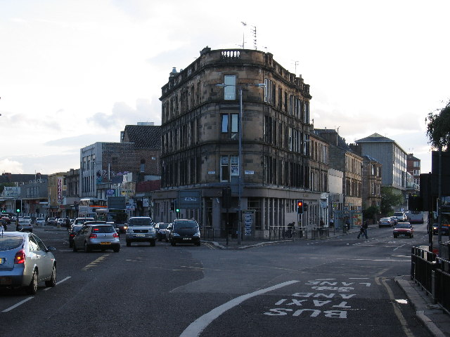
Shawlands Cross. Going south from central
Glasgow you get to Shawlands Cross where there's the Granary pub (Previously Samuel Dow's). Left is Kilmarnock Road, Right Pollokshaws Road
779:
622:
578:
534:
630:
638:
431:
985:
940:
902:
857:
819:
775:
626:
618:
530:
439:
435:
427:
83:
737:
642:
634:
574:
443:
423:
51:
646:
1074:
581:"}},"text\/plain":{"en":{"P275":"Creative Commons Attribution-ShareAlike 2.0 Generic"}}}}": -->
446:"}},"text\/plain":{"en":{"P2699":"https:\/\/www.geograph.org.uk\/profile\/1545"}}}}": -->
649:"}},"text\/plain":{"en":{"P973":"https:\/\/www.geograph.org.uk\/photo\/34877"}}}}": -->
805:
672:
604:
560:
230:
707:
265:
1146:
This file contains additional information, probably added from the digital camera or scanner used to create or digitize it.
355:
487:
995:
954:
912:
871:
829:
789:
685:
656:
544:
508:
495:
480:
747:
715:
700:
588:
453:
412:
1254:
1063:
1058:
42:
311:
947:"}},"text\/plain":{"en":{"P2151":"17.46875 millimetre"}}}}": -->
782:"}},"text\/plain":{"en":{"P4082":"Canon PowerShot S60"}}}}": -->
1149:
If the file has been modified from its original state, some details may not fully reflect the modified file.
354:– If you remix, transform, or build upon the material, you must distribute your contributions under the
272:
on the
Geograph website for the photographer's contact details. The copyright on this image is owned by
864:"}},"text\/plain":{"en":{"P6757":"0.008 second"}}}}": -->
537:"}},"text\/plain":{"en":{"P6216":"copyrighted"}}}}": -->
1091:
The following pages on the
English Knowledge use this file (pages on other projects are not listed):
91:
183:
1299:
515:
308:
167:
722:
692:
8:
1327:
1168:
252:
236:
277:
78:
402:
1158:
1395:
1317:
1281:
1175:
1405:
1204:
156:
146:
1337:
1005:
964:
922:
881:
839:
799:
757:
666:
598:
554:
463:
257:
1095:
269:
1185:
1031:
Click on a date/time to view the file as it appeared at that time.
222:
1123:
215:
55° 49′ 43″ N, 4° 17′ 13″ W
135:
66:
396:
Add a one-line explanation of what this file represents
1113:
1133:
1089:
1104:
1029:
90:
Commons is a freely licensed media file repository.
605:
Creative
Commons Attribution-ShareAlike 2.0 Generic
579:
Creative
Commons Attribution-ShareAlike 2.0 Generic
56:(640 × 480 pixels, file size: 80 KB, MIME type:
1332:Flash fired, auto mode, red-eye reduction mode
365:https://creativecommons.org/licenses/by-sa/2.0
71:
371:Creative Commons Attribution-Share Alike 2.0
289:
131:
116:Shawlands Cross - geograph.org.uk - 34877.jpg
113:
52:Shawlands_Cross_-_geograph.org.uk_-_34877.jpg
444:https:\/\/www.geograph.org.uk\/profile\/1545
152:
141:
14:
944:
861:
647:https:\/\/www.geograph.org.uk\/photo\/34877
331:– to copy, distribute and transmit the work
1106:The following other wikis use this file:
516:https://www.geograph.org.uk/profile/1545
723:https://www.geograph.org.uk/photo/34877
229:View this and other nearby images on:
190:
102:
276:and is licensed for reuse under the
205:
1022:
312:Attribution-Share Alike 2.0 Generic
300:
295:
280:Attribution-ShareAlike 2.0 license.
13:
1144:
401:
395:
286:
263:
120:
103:
49:
1431:
1151:
400:
1195:Date and time of data generation
1090:
386:
342:Under the following conditions:
307:This file is licensed under the
299:
294:
288:
256:
235:
221:
70:
31:
21:
383:
121:
46:No higher resolution available.
1101:
1026:
673:file available on the internet
623:file available on the internet
382:
264:This image was taken from the
26:
1:
830:coordinates of depicted place
820:coordinates of depicted place
36:
1086:
708:Geograph Britain and Ireland
639:Geograph Britain and Ireland
481:object of statement has role
428:object of statement has role
408:Items portrayed in this file
248:
7:
1363:Focal plane resolution unit
1265:Date and time of digitizing
1141:
10:
1436:
1374:One-chip color area sensor
1130:Usage on www.wikidata.org
1120:Usage on ga.wikipedia.org
1110:Usage on eu.wikipedia.org
356:same or compatible license
110:
105:
1238:File change date and time
1023:
845:55°49'43.0"N, 4°17'13.2"W
16:
1355:Focal plane Y resolution
1347:Focal plane X resolution
686:geograph.org.uk image ID
627:geograph.org.uk image ID
385:
322:
77:This is a file from the
41:
1379:Custom image processing
1080:
168:required by the license
134:
81:. Information from its
1273:Image compression mode
1059:17:01, 30 January 2010
270:this photograph's page
241:55.828600; -4.287000
196:s allison /
177:s allison /
84:description page there
1312:4.65625 APEX (f/5.02)
1309:Maximum land aperture
1222:Horizontal resolution
1268:19:47, 5 August 2005
1241:19:47, 5 August 2005
1198:19:47, 5 August 2005
1246:Y and C positioning
1230:Vertical resolution
1169:Canon PowerShot S60
1155:Camera manufacturer
806:Canon PowerShot S60
780:Canon PowerShot S60
337:– to adapt the work
1416:Scene capture type
1400:Auto white balance
496:author name string
436:author name string
1423:
1422:
1180:1/125 sec (0.008)
1102:Global file usage
1084:
946:
863:
589:copyright license
575:copyright license
394:
285:
284:
268:collection. See
246:
245:
203:
202:
171:
99:
98:
79:Wikimedia Commons
32:Global file usage
1427:
1358:9,169.8113207547
1350:9,159.0106007067
1152:
1124:Fearann na Doire
1071:
1033:
973:
890:
725:
720:
716:described at URL
710:
705:
695:
690:
643:described at URL
545:copyright status
531:copyright status
518:
513:
503:
500:
490:
485:
392:
378:
375:
372:
369:
366:
358:as the original.
320:
309:Creative Commons
303:
302:
298:
297:
292:
291:
278:Creative Commons
266:Geograph project
260:
253:
242:
239:
225:
224:
218:
217:
206:
165:
137:
125:
117:
111:
95:
74:
73:
67:
61:
59:
1435:
1434:
1430:
1429:
1428:
1426:
1425:
1424:
1140:
1100:
1092:
1085:
1077:
1069:
1025:
1024:
1021:
1020:
1019:
1018:
1017:
1016:
1015:
1014:
1012:
1002:
1001:
1000:
998:
983:
982:
981:
980:
979:
978:
977:
976:
974:
971:
961:
960:
959:
957:
938:
937:
936:
935:
934:
933:
932:
931:
929:
919:
918:
917:
915:
900:
899:
898:
897:
896:
895:
894:
893:
891:
888:
878:
877:
876:
874:
855:
854:
853:
852:
851:
850:
849:
848:
846:
836:
835:
834:
832:
817:
816:
815:
814:
813:
812:
811:
810:
808:
796:
795:
794:
792:
773:
772:
771:
770:
769:
768:
767:
766:
764:
754:
753:
752:
750:
735:
734:
733:
732:
731:
730:
729:
728:
727:
726:
721:
718:
712:
711:
706:
703:
697:
696:
691:
688:
679:
678:
677:
675:
663:
662:
661:
659:
616:
615:
614:
613:
612:
611:
610:
609:
607:
595:
594:
593:
591:
572:
571:
570:
569:
568:
567:
566:
565:
563:
551:
550:
549:
547:
528:
527:
526:
525:
524:
523:
522:
521:
520:
519:
514:
511:
505:
504:
501:
498:
492:
491:
486:
483:
474:
473:
472:
470:
460:
459:
458:
456:
421:
420:
419:
418:
417:
415:
399:
398:
397:
380:
379:
376:
373:
370:
367:
364:
363:
321:
318:
315:
304:
281:
251:
240:
213:
212:
209:Object location
204:
198:Shawlands Cross
193:
186:
179:Shawlands Cross
174:
147:geograph.org.uk
127:
115:
108:
101:
100:
89:
88:
87:is shown below.
63:
57:
55:
48:
47:
12:
11:
5:
1433:
1421:
1420:
1417:
1413:
1412:
1409:
1402:
1401:
1398:
1392:
1391:
1388:
1384:
1383:
1382:Normal process
1380:
1376:
1375:
1372:
1371:Sensing method
1368:
1367:
1364:
1360:
1359:
1356:
1352:
1351:
1348:
1344:
1343:
1340:
1334:
1333:
1330:
1324:
1323:
1320:
1314:
1313:
1310:
1306:
1305:
1302:
1296:
1295:
1292:
1288:
1287:
1284:
1278:
1277:
1274:
1270:
1269:
1266:
1262:
1261:
1258:
1251:
1250:
1247:
1243:
1242:
1239:
1235:
1234:
1231:
1227:
1226:
1223:
1219:
1218:
1215:
1211:
1210:
1207:
1200:
1199:
1196:
1192:
1191:
1188:
1182:
1181:
1178:
1172:
1171:
1166:
1162:
1161:
1156:
1143:
1139:
1138:
1137:
1136:
1128:
1127:
1126:
1118:
1117:
1116:
1103:
1099:
1098:
1088:
1083:
1082:
1079:
1075:
1072:
1066:
1061:
1056:
1052:
1051:
1048:
1045:
1042:
1039:
1036:
1028:
1013:
1010:
1008:
1007:
1006:
1004:
1003:
999:
994:
992:
991:
990:
989:
987:
975:
969:
967:
966:
965:
963:
962:
958:
953:
951:
950:
949:
948:
942:
930:
927:
925:
924:
923:
921:
920:
916:
911:
909:
908:
907:
906:
904:
892:
886:
884:
883:
882:
880:
879:
875:
870:
868:
867:
866:
865:
859:
847:
844:
842:
841:
840:
838:
837:
833:
828:
826:
825:
824:
823:
821:
809:
804:
802:
801:
800:
798:
797:
793:
788:
786:
785:
784:
783:
781:
777:
765:
762:
760:
759:
758:
756:
755:
751:
746:
744:
743:
742:
741:
739:
714:
713:
699:
698:
684:
683:
682:
681:
680:
676:
671:
669:
668:
667:
665:
664:
660:
657:source of file
655:
653:
652:
651:
650:
648:
644:
640:
636:
632:
628:
624:
620:
619:source of file
608:
603:
601:
600:
599:
597:
596:
592:
587:
585:
584:
583:
582:
580:
576:
564:
559:
557:
556:
555:
553:
552:
548:
543:
541:
540:
539:
538:
536:
532:
507:
506:
494:
493:
479:
478:
477:
476:
475:
471:
468:
466:
465:
464:
462:
461:
457:
452:
450:
449:
448:
447:
445:
441:
437:
433:
429:
425:
416:
411:
409:
406:
405:
404:
403:
391:
390:
387:
384:
362:
361:
360:
359:
349:
340:
339:
338:
332:
325:You are free:
316:
306:
305:
287:
283:
282:
261:
250:
247:
244:
243:
233:
227:
210:
201:
200:
194:
191:
188:
187:
182:
175:
172:
160:
159:
154:
150:
149:
143:
139:
138:
133:
129:
128:
118:
109:
107:
104:
97:
96:
75:
65:
64:
45:
40:
39:
34:
29:
24:
19:
9:
6:
4:
3:
2:
1432:
1418:
1415:
1414:
1410:
1407:
1404:
1403:
1399:
1397:
1396:White balance
1394:
1393:
1390:Auto exposure
1389:
1387:Exposure mode
1386:
1385:
1381:
1378:
1377:
1373:
1370:
1369:
1365:
1362:
1361:
1357:
1354:
1353:
1349:
1346:
1345:
1341:
1339:
1336:
1335:
1331:
1329:
1326:
1325:
1321:
1319:
1318:Metering mode
1316:
1315:
1311:
1308:
1307:
1303:
1301:
1300:Exposure bias
1298:
1297:
1293:
1291:APEX aperture
1290:
1289:
1285:
1283:
1282:Shutter speed
1280:
1279:
1275:
1272:
1271:
1267:
1264:
1263:
1259:
1256:
1253:
1252:
1248:
1245:
1244:
1240:
1237:
1236:
1232:
1229:
1228:
1224:
1221:
1220:
1216:
1213:
1212:
1208:
1206:
1202:
1201:
1197:
1194:
1193:
1189:
1187:
1184:
1183:
1179:
1177:
1176:Exposure time
1174:
1173:
1170:
1167:
1164:
1163:
1160:
1157:
1154:
1153:
1150:
1147:
1135:
1132:
1131:
1129:
1125:
1122:
1121:
1119:
1115:
1112:
1111:
1109:
1108:
1107:
1097:
1094:
1093:
1078:
1073:
1067:
1065:
1062:
1060:
1057:
1054:
1053:
1049:
1046:
1043:
1040:
1037:
1035:
1034:
1032:
1009:
997:
993:
968:
956:
952:
926:
914:
910:
885:
873:
872:exposure time
869:
858:exposure time
843:
831:
827:
807:
803:
791:
790:captured with
787:
776:captured with
763:5 August 2005
761:
749:
745:
724:
717:
709:
702:
694:
687:
674:
670:
658:
654:
606:
602:
590:
586:
562:
558:
546:
542:
517:
510:
497:
489:
482:
467:
455:
451:
414:
410:
407:
388:
381:
368:CC BY-SA 2.0
357:
353:
350:
347:
344:
343:
341:
336:
333:
330:
327:
326:
324:
323:
317:Attribution:
313:
310:
293:
279:
275:
271:
267:
262:
259:
255:
254:
238:
234:
232:
231:OpenStreetMap
228:
226:
216:
211:
208:
207:
199:
195:
189:
185:
181: /
180:
176:
169:
164:
162:
161:
158:
155:
151:
148:
144:
140:
136:5 August 2005
130:
124:
119:
112:
93:
86:
85:
80:
76:
69:
68:
62:
53:
44:
38:
35:
33:
30:
28:
25:
23:
20:
18:
15:
1406:Digital zoom
1205:focal length
1165:Camera model
1148:
1145:
1105:
1030:
1027:File history
955:focal length
941:focal length
488:photographer
432:photographer
351:
345:
334:
328:
273:
197:
184:CC BY-SA 2.0
178:
122:
92:You can help
82:
50:
22:File history
1338:Color space
1214:Orientation
1209:17.46875 mm
1076:GeographBot
561:copyrighted
535:copyrighted
352:share alike
346:attribution
163:Attribution
114:Description
1087:File usage
1068:640 × 480
1044:Dimensions
1011:image/jpeg
996:media type
986:media type
972:millimetre
945:millimetre
469:some value
58:image/jpeg
27:File usage
1114:Shawlands
1096:Shawlands
1041:Thumbnail
1038:Date/Time
970:17.46875
748:inception
738:inception
502:s allison
319:s allison
274:s allison
249:Licensing
192:InfoField
173:InfoField
157:s allison
123:English:
1419:Standard
1249:Centered
1186:F-number
1142:Metadata
1134:Q7491272
913:f-number
903:f-number
701:operator
635:operator
389:Captions
335:to remix
329:to share
314:license.
37:Metadata
1322:Pattern
1294:4.65625
1286:6.96875
1257:version
1233:180 dpi
1225:180 dpi
1070:(80 KB)
1055:current
1050:Comment
454:creator
424:creator
413:depicts
393:English
106:Summary
54:
1366:inches
1217:Normal
889:second
887:0.008
862:second
219:
153:Author
142:Source
1408:ratio
1328:Flash
1203:Lens
1159:Canon
693:34877
631:34877
145:From
1342:sRGB
1255:Exif
1047:User
377:true
374:true
132:Date
17:File
1260:2.2
1190:f/5
509:URL
440:URL
719::
704::
689::
512::
499::
484::
1411:1
1304:0
1276:5
928:5
170:)
166:(
94:.
60:)
_&language=en)
