837:"}},"text\/plain":{"en":{"":"coordinates of the point of view"}}},"{\"value\":{\"latitude\":53.29308,\"longitude\":-3.6743,\"altitude\":null,\"precision\":1.0e-5,\"globe\":\"http:\\\/\\\/www.wikidata.org\\\/entity\\\/Q2\"},\"type\":\"globecoordinate\"}":{"text\/html":{"en":{"P1259":"53\u00b017'35.09"N, 3\u00b040'27.48"W"}},"text\/plain":{"en":{"P1259":"53\u00b017'35.09\"N, 3\u00b040'27.48\"W"}}},"{\"value\":{\"entity-type\":\"property\",\"numeric-id\":7787,\"id\":\"P7787\"},\"type\":\"wikibase-entityid\"}":{"text\/html":{"en":{"":"
905:"}},"text\/plain":{"en":{"":"coordinates of depicted place"}}},"{\"value\":{\"latitude\":53.29308,\"longitude\":-3.6743,\"altitude\":null,\"precision\":1.0e-5,\"globe\":\"http:\\\/\\\/www.wikidata.org\\\/entity\\\/Q2\"},\"type\":\"globecoordinate\"}":{"text\/html":{"en":{"P9149":"53\u00b017'35.09"N, 3\u00b040'27.48"W"}},"text\/plain":{"en":{"P9149":"53\u00b017'35.09\"N, 3\u00b040'27.48\"W"}}},"{\"value\":{\"entity-type\":\"property\",\"numeric-id\":7787,\"id\":\"P7787\"},\"type\":\"wikibase-entityid\"}":{"text\/html":{"en":{"":"
497:"}},"text\/plain":{"en":{"":"author name string"}}},"{\"value\":\"Jonathan Wilkins\",\"type\":\"string\"}":{"text\/html":{"en":{"P2093":"Jonathan Wilkins"}},"text\/plain":{"en":{"P2093":"Jonathan Wilkins"}}},"{\"value\":{\"entity-type\":\"property\",\"numeric-id\":2699,\"id\":\"P2699\"},\"type\":\"wikibase-entityid\"}":{"text\/html":{"en":{"":"
799:"}},"text\/plain":{"en":{"":"inception"}}},"{\"value\":{\"time\":\"+2008-04-23T00:00:00Z\",\"timezone\":0,\"before\":0,\"after\":0,\"precision\":11,\"calendarmodel\":\"http:\\\/\\\/www.wikidata.org\\\/entity\\\/Q1985727\"},\"type\":\"time\"}":{"text\/html":{"en":{"P571":"23 April 2008"}},"text\/plain":{"en":{"P571":"23 April 2008"}}}}": -->
676:
282:
232:
274:
224:
901:
246:
317:
355:
360:
72:
692:"}},"text\/plain":{"en":{"P973":"https:\/\/www.geograph.org.uk\/photo\/775461"}}},"{\"value\":{\"entity-type\":\"property\",\"numeric-id\":7384,\"id\":\"P7384\"},\"type\":\"wikibase-entityid\"}":{"text\/html":{"en":{"":"
684:"}},"text\/plain":{"en":{"P7482":"file available on the internet"}}},"{\"value\":{\"entity-type\":\"property\",\"numeric-id\":973,\"id\":\"P973\"},\"type\":\"wikibase-entityid\"}":{"text\/html":{"en":{"":"
489:"}},"text\/plain":{"en":{"":"object of statement has role"}}},"{\"value\":{\"entity-type\":\"item\",\"numeric-id\":33231,\"id\":\"Q33231\"},\"type\":\"wikibase-entityid\"}":{"text\/html":{"en":{"P3831":"
973:"}},"text\/plain":{"en":{"":"media type"}}},"{\"value\":\"image\\\/jpeg\",\"type\":\"string\"}":{"text\/html":{"en":{"P1163":"image\/jpeg"}},"text\/plain":{"en":{"P1163":"image\/jpeg"}}}}": -->
636:"}},"text\/plain":{"en":{"":"copyright license"}}},"{\"value\":{\"entity-type\":\"item\",\"numeric-id\":19068220,\"id\":\"Q19068220\"},\"type\":\"wikibase-entityid\"}":{"text\/html":{"en":{"P275":"
592:"}},"text\/plain":{"en":{"":"copyright status"}}},"{\"value\":{\"entity-type\":\"item\",\"numeric-id\":50423863,\"id\":\"Q50423863\"},\"type\":\"wikibase-entityid\"}":{"text\/html":{"en":{"P6216":"
680:"}},"text\/plain":{"en":{"":"source of file"}}},"{\"value\":{\"entity-type\":\"item\",\"numeric-id\":74228490,\"id\":\"Q74228490\"},\"type\":\"wikibase-entityid\"}":{"text\/html":{"en":{"P7482":"
493:"}},"text\/plain":{"en":{"P3831":"photographer"}}},"{\"value\":{\"entity-type\":\"property\",\"numeric-id\":2093,\"id\":\"P2093\"},\"type\":\"wikibase-entityid\"}":{"text\/html":{"en":{"":"
909:"}},"text\/plain":{"en":{"":"heading"}}},"{\"value\":{\"amount\":\"+292\",\"unit\":\"http:\\\/\\\/www.wikidata.org\\\/entity\\\/Q28390\"},\"type\":\"quantity\"}":{"text\/html":{"en":{"P7787":"292
841:"}},"text\/plain":{"en":{"":"heading"}}},"{\"value\":{\"amount\":\"+292\",\"unit\":\"http:\\\/\\\/www.wikidata.org\\\/entity\\\/Q28390\"},\"type\":\"quantity\"}":{"text\/html":{"en":{"P7787":"292
704:"}},"text\/plain":{"en":{"":"operator"}}},"{\"value\":{\"entity-type\":\"item\",\"numeric-id\":1503119,\"id\":\"Q1503119\"},\"type\":\"wikibase-entityid\"}":{"text\/html":{"en":{"P137":"
700:"}},"text\/plain":{"en":{"P7384":"775461"}}},"{\"value\":{\"entity-type\":\"property\",\"numeric-id\":137,\"id\":\"P137\"},\"type\":\"wikibase-entityid\"}":{"text\/html":{"en":{"":"
485:"}},"text\/plain":{"en":{"":"creator"}}},"{\"value\":{\"entity-type\":\"property\",\"numeric-id\":3831,\"id\":\"P3831\"},\"type\":\"wikibase-entityid\"}":{"text\/html":{"en":{"":"
969:
688:"}},"text\/plain":{"en":{"":"described at URL"}}},"{\"value\":\"https:\\\/\\\/www.geograph.org.uk\\\/photo\\\/775461\",\"type\":\"string\"}":{"text\/html":{"en":{"P973":"
126:
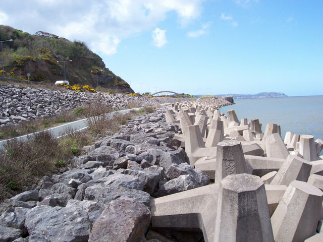
Sea defences The route of the A55 'Col-Con' Expressway was severely constrained by the coastal topography and built environment. Here the road passes through the site of a large coastal quarry and considerable engineering was required to create and defend the new formation. Cast-concrete anchor
501:"}},"text\/plain":{"en":{"":"URL"}}},"{\"value\":\"https:\\\/\\\/www.geograph.org.uk\\\/profile\\\/7090\",\"type\":\"string\"}":{"text\/html":{"en":{"P2699":"
1066:== {{int:filedesc}} == {{Information |description={{en|1=Sea defences The route of the A55 'Col-Con' Expressway was severely constrained by the coastal topography and built environment. Here the road passes through the site of a large coastal quarry and c
696:"}},"text\/plain":{"en":{"":"geograph.org.uk image ID"}}},"{\"value\":\"775461\",\"type\":\"string\"}":{"text\/html":{"en":{"P7384":"
265:
43:
215:
127:
blocks interlock to provide a primary energy-dispersive barrier, with conventional rock-armour to stabilise the upper slope. Very geometric, but very dangerous because the structure includes large voids into which anything can drop easily.
407:– You must give appropriate credit, provide a link to the license, and indicate if changes were made. You may do so in any reasonable manner, but not in any way that suggests the licensor endorses you or your use.
279:
229:
697:
681:
637:
593:
705:
490:
970:
906:
902:
838:
834:
693:
677:
589:
498:
494:
486:
796:
701:
689:
685:
633:
502:
482:
83:
51:
1059:
640:"}},"text\/plain":{"en":{"P275":"Creative Commons Attribution-ShareAlike 2.0 Generic"}}}}": -->
505:"}},"text\/plain":{"en":{"P2699":"https:\/\/www.geograph.org.uk\/profile\/7090"}}}}": -->
731:
663:
619:
289:
239:
781:
324:
1131:
This file contains additional information, probably added from the digital camera or scanner used to create or digitize it.
414:
546:
980:
947:
920:
879:
852:
759:
715:
603:
567:
554:
539:
806:
774:
744:
647:
512:
471:
708:"}},"text\/plain":{"en":{"P137":"Geograph Britain and Ireland"}}}}": -->
370:
1048:
1043:
42:
1134:
If the file has been modified from its original state, some details may not fully reflect the modified file.
413:– If you remix, transform, or build upon the material, you must distribute your contributions under the
331:
on the
Geograph website for the photographer's contact details. The copyright on this image is owned by
596:"}},"text\/plain":{"en":{"P6216":"copyrighted"}}}}": -->
1076:
The following pages on the
English Knowledge use this file (pages on other projects are not listed):
913:"}},"text\/plain":{"en":{"P7787":"292 degree"}}}}": -->
845:"}},"text\/plain":{"en":{"P7787":"292 degree"}}}}": -->
91:
1108:
184:
766:
751:
574:
367:
168:
8:
311:
295:
245:
336:
78:
461:
157:
147:
990:
930:
862:
816:
725:
657:
613:
522:
316:
328:
1016:
Click on a date/time to view the file as it appeared at that time.
1098:
281:
231:
1080:
266:
53° 17′ 35″ N, 3° 40′ 27″ W
216:
53° 17′ 35″ N, 3° 40′ 27″ W
136:
66:
1118:
455:
Add a one-line explanation of what this file represents
1074:
1089:
1014:
90:
Commons is a freely licensed media file repository.
664:
Creative
Commons Attribution-ShareAlike 2.0 Generic
638:
Creative
Commons Attribution-ShareAlike 2.0 Generic
56:(640 × 480 pixels, file size: 80 KB, MIME type:
424:https://creativecommons.org/licenses/by-sa/2.0
71:
430:Creative Commons Attribution-Share Alike 2.0
348:
132:
113:
690:https:\/\/www.geograph.org.uk\/photo\/775461
503:https:\/\/www.geograph.org.uk\/profile\/7090
153:
142:
14:
910:
842:
390:– to copy, distribute and transmit the work
116:Sea defences - geograph.org.uk - 775461.jpg
52:Sea_defences_-_geograph.org.uk_-_775461.jpg
1091:The following other wikis use this file:
752:https://www.geograph.org.uk/photo/775461
575:https://www.geograph.org.uk/profile/7090
288:View this and other nearby images on:
238:View this and other nearby images on:
191:
102:
335:and is licensed for reuse under the
256:
206:
1007:
371:Attribution-Share Alike 2.0 Generic
359:
354:
339:Attribution-ShareAlike 2.0 license.
13:
1129:
460:
454:
345:
322:
120:
103:
49:
1155:
1136:
459:
1075:
853:coordinates of the point of view
835:coordinates of the point of view
445:
401:Under the following conditions:
366:This file is licensed under the
358:
353:
347:
315:
294:
280:
272:
244:
230:
222:
70:
31:
21:
442:
121:
46:No higher resolution available.
1086:
1011:
732:file available on the internet
682:file available on the internet
441:
323:This image was taken from the
26:
1:
921:coordinates of depicted place
903:coordinates of depicted place
197:Jonathan Wilkins /
178:Jonathan Wilkins /
36:
1071:
782:Geograph Britain and Ireland
706:Geograph Britain and Ireland
540:object of statement has role
487:object of statement has role
467:Items portrayed in this file
307:
271:
221:
7:
1126:
936:53°17'35.09"N, 3°40'27.48"W
868:53°17'35.09"N, 3°40'27.48"W
10:
1160:
1115:Usage on id.wikipedia.org
1105:Usage on fa.wikipedia.org
1095:Usage on de.wikipedia.org
415:same or compatible license
110:
105:
1008:
16:
760:geograph.org.uk image ID
694:geograph.org.uk image ID
444:
381:
77:This is a file from the
41:
1065:
1044:22:57, 19 February 2011
169:required by the license
135:
81:. Information from its
329:this photograph's page
300:53.293080; -3.674300
250:53.293080; -3.674300
84:description page there
396:– to adapt the work
555:author name string
495:author name string
1147:
1146:
1087:Global file usage
1069:
912:
844:
648:copyright license
634:copyright license
453:
344:
343:
327:collection. See
305:
304:
255:
254:
204:
203:
172:
99:
98:
79:Wikimedia Commons
32:Global file usage
1151:
1137:
1056:
1018:
958:
957:
952:
890:
889:
884:
784:
779:
769:
764:
754:
749:
745:described at URL
686:described at URL
604:copyright status
590:copyright status
577:
572:
562:
561:Jonathan Wilkins
559:
549:
544:
451:
437:
434:
431:
428:
425:
417:as the original.
379:
378:Jonathan Wilkins
368:Creative Commons
362:
361:
357:
356:
351:
350:
337:Creative Commons
333:Jonathan Wilkins
325:Geograph project
319:
312:
301:
298:
284:
283:
277:
276:
275:
269:
268:
257:
251:
248:
234:
233:
227:
226:
225:
219:
218:
207:
166:
158:Jonathan Wilkins
138:
125:
117:
111:
95:
74:
73:
67:
61:
59:
1159:
1158:
1154:
1153:
1152:
1150:
1149:
1148:
1125:
1085:
1077:
1070:
1062:
1054:
1010:
1009:
1006:
1005:
1004:
1003:
1002:
1001:
1000:
999:
997:
987:
986:
985:
983:
968:
967:
966:
965:
964:
963:
962:
961:
960:
959:
955:
953:
950:
941:
940:
939:
937:
927:
926:
925:
923:
900:
899:
898:
897:
896:
895:
894:
893:
892:
891:
887:
885:
882:
873:
872:
871:
869:
859:
858:
857:
855:
832:
831:
830:
829:
828:
827:
826:
825:
823:
813:
812:
811:
809:
794:
793:
792:
791:
790:
789:
788:
787:
786:
785:
780:
777:
771:
770:
765:
762:
756:
755:
750:
747:
738:
737:
736:
734:
722:
721:
720:
718:
675:
674:
673:
672:
671:
670:
669:
668:
666:
654:
653:
652:
650:
631:
630:
629:
628:
627:
626:
625:
624:
622:
610:
609:
608:
606:
587:
586:
585:
584:
583:
582:
581:
580:
579:
578:
573:
570:
564:
563:
560:
557:
551:
550:
545:
542:
533:
532:
531:
529:
519:
518:
517:
515:
480:
479:
478:
477:
476:
474:
458:
457:
456:
439:
438:
435:
432:
429:
426:
423:
422:
380:
377:
374:
363:
340:
310:
299:
273:
264:
263:
260:Object location
249:
223:
214:
213:
210:Camera location
205:
194:
187:
175:
148:geograph.org.uk
128:
115:
108:
101:
100:
89:
88:
87:is shown below.
63:
57:
55:
48:
47:
12:
11:
5:
1157:
1145:
1144:
1141:
1128:
1124:
1123:
1122:
1121:
1113:
1112:
1111:
1103:
1102:
1101:
1099:Steinschüttung
1088:
1084:
1083:
1073:
1068:
1067:
1064:
1060:
1057:
1051:
1046:
1041:
1037:
1036:
1033:
1030:
1027:
1024:
1021:
1013:
998:
995:
993:
992:
991:
989:
988:
984:
979:
977:
976:
975:
974:
972:
946:
945:
944:
943:
942:
938:
935:
933:
932:
931:
929:
928:
924:
919:
917:
916:
915:
914:
908:
904:
878:
877:
876:
875:
874:
870:
867:
865:
864:
863:
861:
860:
856:
851:
849:
848:
847:
846:
840:
836:
824:
821:
819:
818:
817:
815:
814:
810:
805:
803:
802:
801:
800:
798:
773:
772:
758:
757:
743:
742:
741:
740:
739:
735:
730:
728:
727:
726:
724:
723:
719:
716:source of file
714:
712:
711:
710:
709:
707:
703:
699:
695:
691:
687:
683:
679:
678:source of file
667:
662:
660:
659:
658:
656:
655:
651:
646:
644:
643:
642:
641:
639:
635:
623:
618:
616:
615:
614:
612:
611:
607:
602:
600:
599:
598:
597:
595:
591:
566:
565:
553:
552:
538:
537:
536:
535:
534:
530:
527:
525:
524:
523:
521:
520:
516:
511:
509:
508:
507:
506:
504:
500:
496:
492:
488:
484:
475:
470:
468:
465:
464:
463:
462:
450:
449:
446:
443:
421:
420:
419:
418:
408:
399:
398:
397:
391:
384:You are free:
375:
365:
364:
346:
342:
341:
320:
309:
306:
303:
302:
292:
286:
261:
253:
252:
242:
236:
211:
202:
201:
195:
192:
189:
188:
183:
176:
173:
161:
160:
155:
151:
150:
144:
140:
139:
134:
130:
129:
118:
109:
107:
104:
97:
96:
75:
65:
64:
45:
40:
39:
34:
29:
24:
19:
9:
6:
4:
3:
2:
1156:
1142:
1139:
1138:
1135:
1132:
1120:
1117:
1116:
1114:
1110:
1107:
1106:
1104:
1100:
1097:
1096:
1094:
1093:
1092:
1082:
1079:
1078:
1063:
1058:
1052:
1050:
1047:
1045:
1042:
1039:
1038:
1034:
1031:
1028:
1025:
1022:
1020:
1019:
1017:
994:
982:
978:
949:
934:
922:
918:
881:
866:
854:
850:
822:23 April 2008
820:
808:
804:
783:
776:
768:
761:
753:
746:
733:
729:
717:
713:
665:
661:
649:
645:
621:
617:
605:
601:
576:
569:
556:
548:
541:
526:
514:
510:
473:
469:
466:
447:
440:
427:CC BY-SA 2.0
416:
412:
409:
406:
403:
402:
400:
395:
392:
389:
386:
385:
383:
382:
376:Attribution:
372:
369:
352:
338:
334:
330:
326:
321:
318:
314:
313:
297:
293:
291:
290:OpenStreetMap
287:
285:
267:
262:
259:
258:
247:
243:
241:
240:OpenStreetMap
237:
235:
217:
212:
209:
208:
200:
196:
190:
186:
182: /
181:
177:
170:
165:
163:
162:
159:
156:
152:
149:
145:
141:
137:23 April 2008
131:
124:
119:
112:
93:
86:
85:
80:
76:
69:
68:
62:
53:
44:
38:
35:
33:
30:
28:
25:
23:
20:
18:
15:
1133:
1130:
1090:
1015:
1012:File history
547:photographer
491:photographer
410:
404:
393:
387:
332:
270:
220:
199:Sea defences
198:
185:CC BY-SA 2.0
180:Sea defences
179:
122:
92:You can help
82:
50:
22:File history
1119:Batu halang
1061:GeographBot
620:copyrighted
594:copyrighted
411:share alike
405:attribution
164:Attribution
114:Description
1140:_error
1072:File usage
1053:640 × 480
1029:Dimensions
996:image/jpeg
981:media type
971:media type
528:some value
58:image/jpeg
27:File usage
1026:Thumbnail
1023:Date/Time
807:inception
797:inception
308:Licensing
193:InfoField
174:InfoField
123:English:
1127:Metadata
1109:سنگلاشه
775:operator
702:operator
448:Captions
394:to remix
388:to share
373:license.
37:Metadata
1055:(80 KB)
1040:current
1035:Comment
948:heading
907:heading
880:heading
839:heading
513:creator
483:creator
472:depicts
452:English
106:Summary
54:
1081:Riprap
956:degree
911:degree
888:degree
843:degree
767:775461
698:775461
278:
228:
154:Author
143:Source
146:From
1032:User
954:292
886:292
436:true
433:true
133:Date
17:File
568:URL
499:URL
951::
883::
778::
763::
748::
571::
558::
543::
1143:0
171:)
167:(
94:.
60:)
Text is available under the Creative Commons Attribution-ShareAlike License. Additional terms may apply.
_heading:292.00&language=en)
_heading:292.00&language=en)
