606:"}},"text\/plain":{"en":{"":"coordinates of the point of view"}}},"{\"value\":{\"latitude\":11.316667,\"longitude\":166.783333,\"altitude\":null,\"precision\":1.0e-6,\"globe\":\"http:\\\/\\\/www.wikidata.org\\\/entity\\\/Q2\"},\"type\":\"globecoordinate\"}":{"text\/html":{"en":{"P1259":"11\u00b019'0.001"N, 166\u00b046'59.999"E"}},"text\/plain":{"en":{"P1259":"11\u00b019'0.001\"N, 166\u00b046'59.999\"E"}}}}": -->
43:
568:"}},"text\/plain":{"en":{"":"inception"}}},"{\"value\":{\"time\":\"+2014-12-06T00:00:00Z\",\"timezone\":0,\"before\":0,\"after\":0,\"precision\":11,\"calendarmodel\":\"http:\\\/\\\/www.wikidata.org\\\/entity\\\/Q1985727\"},\"type\":\"time\"}":{"text\/html":{"en":{"P571":"6 December 2014"}},"text\/plain":{"en":{"P571":"6 December 2014"}}}}": -->
215:
468:
319:
270:
103:
308:
488:"}},"text\/plain":{"en":{"":"determination method"}}},"{\"value\":{\"entity-type\":\"item\",\"numeric-id\":60671452,\"id\":\"Q60671452\"},\"type\":\"wikibase-entityid\"}":{"text\/html":{"en":{"P459":"
484:"}},"text\/plain":{"en":{"P1001":"United States of America"}}},"{\"value\":{\"entity-type\":\"property\",\"numeric-id\":459,\"id\":\"P459\"},\"type\":\"wikibase-entityid\"}":{"text\/html":{"en":{"":"
480:"}},"text\/plain":{"en":{"":"applies to jurisdiction"}}},"{\"value\":{\"entity-type\":\"item\",\"numeric-id\":30,\"id\":\"Q30\"},\"type\":\"wikibase-entityid\"}":{"text\/html":{"en":{"P1001":"
472:"}},"text\/plain":{"en":{"":"copyright status"}}},"{\"value\":{\"entity-type\":\"item\",\"numeric-id\":19652,\"id\":\"Q19652\"},\"type\":\"wikibase-entityid\"}":{"text\/html":{"en":{"P6216":"
476:"}},"text\/plain":{"en":{"P6216":"public domain"}}},"{\"value\":{\"entity-type\":\"property\",\"numeric-id\":1001,\"id\":\"P1001\"},\"type\":\"wikibase-entityid\"}":{"text\/html":{"en":{"":"
682:
602:
206:
412:
692:
69:
65:
61:
57:
53:
47:
159:
NASA Landsat 8 OLI bands used were 4 (red), 3 (green), 2 (blue). Pan-sharpened with band 8. Manual color balance. Projection: UTM (zone 58), WGS84. Imagery courtesy NASA/USGS.
489:
114:
82:
473:
603:
477:
469:
565:
485:
481:
866:
776:
492:"}},"text\/plain":{"en":{"P459":"work of the federal government of the United States"}}}}": -->
391:
joint project implies that all materials created by its probe are copyrighted and require permission for commercial non-educational use.
340:
550:
222:
889:
This file contains additional information, probably added from the digital camera or scanner used to create or digitize it.
515:
408:
388:
613:
528:
499:
366:
575:
543:
458:
535:
681:
676:
73:
42:
398:
351:
892:
If the file has been modified from its original state, some details may not fully reflect the modified file.
816:
416:
419:
states that all of the images in the photo gallery are in the public domain "Unless otherwise noted."
709:
The following pages on the
English Knowledge use this file (pages on other projects are not listed):
362:
122:
392:
856:
347:
8:
403:
379:
373:
295:
291:
228:
109:
448:
286:. NASA copyright policy states that "NASA material is not protected by copyright
718:
278:
713:
623:
585:
509:
746:
299:
157:
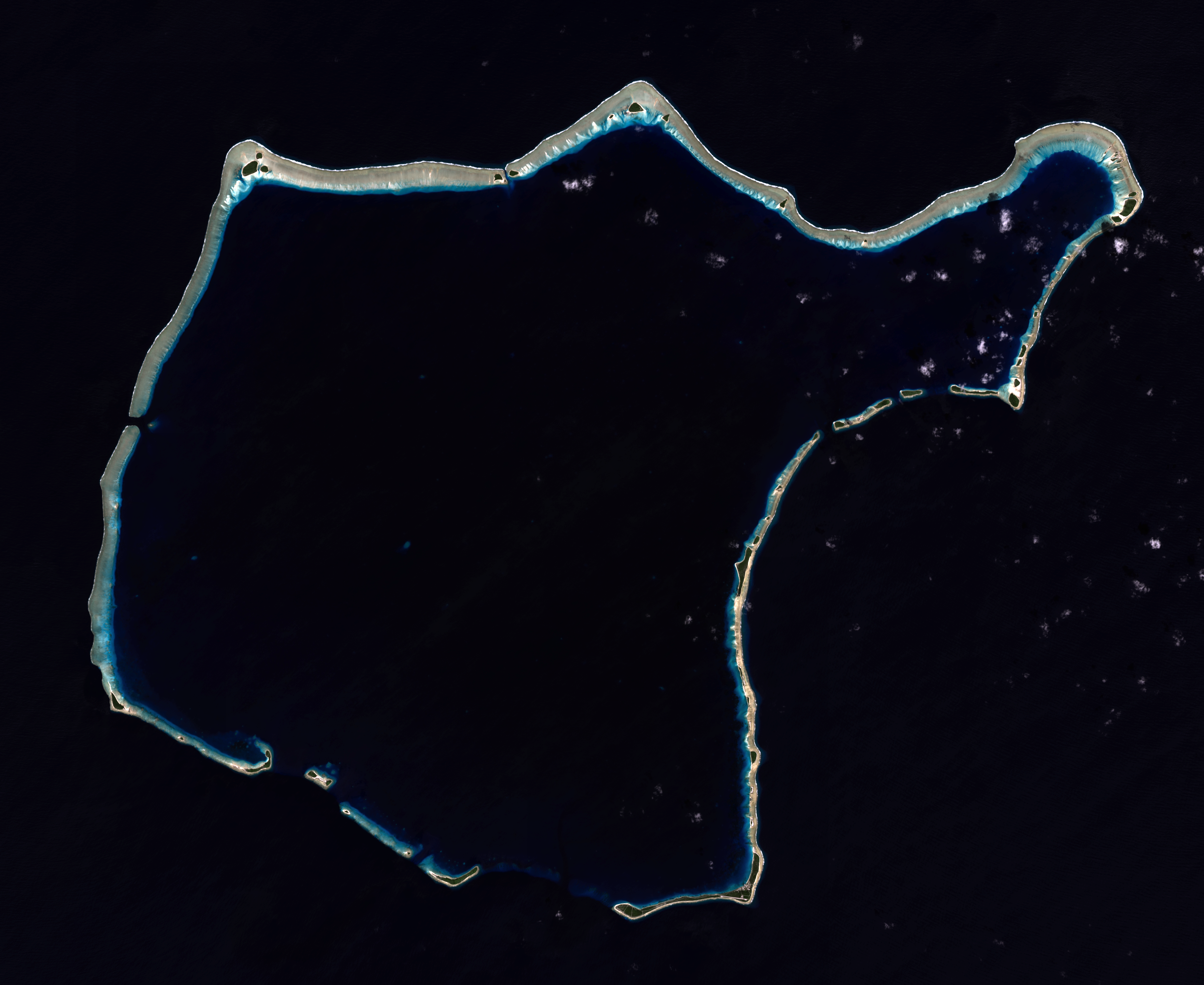
Composite "true color" multispectral satellite image of
Rongelap Atoll.
336:
736:
649:
Click on a date/time to view the file as it appeared at that time.
370:
365:
data may be copyrighted if they are not explicitly produced by the
826:
161:(note: atmospheric haze is present and could not be fully removed)
214:
283:
207:
11° 19′ 00″ N, 166° 47′ 00″ E
806:
181:
346:
The NASA website hosts a large number of images from the
170:
97:
846:
442:
Add a one-line explanation of what this file represents
796:
282:
in the United States because it was solely created by
87:(3,741 × 3,060 pixels, file size: 7.88 MB, MIME type:
836:
786:
766:
707:
876:
727:
647:
121:
Commons is a freely licensed media file repository.
756:
551:
work of the federal government of the United States
490:
work of the federal government of the United States
354:, and other non-American space agencies. These are
180:NASA/USGS Landsat satellite image GeoTIFF archive,
339:, insignia and emblems is restricted per U.S. law
147:Rongelap Atoll - 2014-12-06 - Landsat 8 - 15m.png
102:
166:
144:
187:
176:
14:
729:The following other wikis use this file:
817:Māršala Salu administratīvais iedalījums
221:View this and other nearby images on:
269:
133:
411:(NSSDC) site has been known to host
402:(APOD) web site may be copyrighted.
264:
197:
699:User created page with UploadWizard
640:
13:
887:
447:
441:
409:National Space Science Data Center
317:
306:
151:
134:
80:
943:
894:
446:
708:
614:coordinates of the point of view
604:coordinates of the point of view
432:
268:
227:
213:
101:
31:
21:
429:
152:
904:Wed 21 Jan 2015 19:45:38 -0700
724:
644:
629:11°19'0.001"N, 166°46'59.999"E
428:
26:
1:
36:
704:
454:Items portrayed in this file
399:Astronomy Picture of the Day
240:
7:
898:Date and time of digitizing
884:
793:Usage on fr.wiktionary.org
753:Usage on en.wikivoyage.org
743:Usage on ceb.wikipedia.org
733:Usage on ast.wikipedia.org
10:
948:
873:Usage on www.wikidata.org
863:Usage on ur.wikipedia.org
853:Usage on uk.wikipedia.org
843:Usage on pl.wikipedia.org
833:Usage on no.wikipedia.org
823:Usage on mt.wikipedia.org
813:Usage on lv.wikipedia.org
803:Usage on id.wikipedia.org
783:Usage on fr.wikipedia.org
773:Usage on fa.wikipedia.org
763:Usage on es.wikipedia.org
747:Rongelap Atoll (munisipyo)
296:NASA copyright policy page
141:
136:
912:File change date and time
641:
16:
536:United States of America
482:United States of America
431:
108:This is a file from the
41:
698:
529:applies to jurisdiction
478:applies to jurisdiction
396:Images featured on the
169:
112:. Information from its
915:02:51, 22 January 2015
677:02:57, 22 January 2015
363:Hubble Space Telescope
322:
311:
233:11.316667; 166.783333
182:http://glovis.usgs.gov
115:description page there
46:Size of this preview:
920:Horizontal resolution
867:رونگیلاپ جزیرہ مرجانی
389:SOHO (ESA & NASA)
358:in the public domain.
321:
310:
544:determination method
486:determination method
352:Russian space agency
300:JPL Image Use Policy
276:This file is in the
74:3,741 × 3,060 pixels
70:2,504 × 2,048 pixels
66:1,252 × 1,024 pixels
928:Vertical resolution
777:جزیره مرجانی رانگلپ
413:copyrighted content
361:Materials based on
52:Other resolutions:
737:Atolón de Rongelap
323:
312:
935:
934:
725:Global file usage
702:
440:
426:
425:
417:photo gallery FAQ
330:
292:Template:PD-USGov
263:
262:
238:
237:
195:
194:
130:
129:
110:Wikimedia Commons
32:Global file usage
939:
905:
895:
827:Gżejjer Marshall
689:
651:
553:
548:
538:
533:
500:copyright status
470:copyright status
438:
382:
376:
326:
320:
309:
272:
271:
265:
259:
256:
253:
250:
245:
244:
234:
231:
217:
216:
210:
209:
198:
172:
156:
148:
142:
126:
105:
104:
98:
92:
90:
77:
62:939 × 768 pixels
58:587 × 480 pixels
54:294 × 240 pixels
48:733 × 600 pixels
947:
946:
942:
941:
940:
938:
937:
936:
903:
883:
723:
710:
703:
695:
687:
643:
642:
639:
638:
637:
636:
635:
634:
633:
632:
630:
620:
619:
618:
616:
601:
600:
599:
598:
597:
596:
595:
594:
592:
591:6 December 2014
582:
581:
580:
578:
563:
562:
561:
560:
559:
558:
557:
556:
555:
554:
549:
546:
540:
539:
534:
531:
522:
521:
520:
518:
506:
505:
504:
502:
467:
466:
465:
464:
463:
461:
445:
444:
443:
422:
380:
374:
356:not necessarily
318:
307:
257:
254:
251:
248:
243:
232:
205:
204:
201:Camera location
196:
171:6 December 2014
162:
146:
139:
132:
131:
120:
119:
118:is shown below.
94:
88:
86:
79:
78:
51:
12:
11:
5:
945:
933:
932:
929:
925:
924:
921:
917:
916:
913:
909:
908:
907:
906:
899:
886:
882:
881:
880:
879:
871:
870:
869:
861:
860:
859:
851:
850:
849:
841:
840:
839:
831:
830:
829:
821:
820:
819:
811:
810:
809:
801:
800:
799:
791:
790:
789:
781:
780:
779:
771:
770:
769:
761:
760:
759:
751:
750:
749:
741:
740:
739:
726:
722:
721:
719:Rongelap Atoll
716:
706:
701:
700:
697:
693:
690:
686:3,741 × 3,060
684:
679:
674:
670:
669:
666:
663:
660:
657:
654:
646:
631:
628:
626:
625:
624:
622:
621:
617:
612:
610:
609:
608:
607:
605:
593:
590:
588:
587:
586:
584:
583:
579:
574:
572:
571:
570:
569:
567:
542:
541:
527:
526:
525:
524:
523:
519:
514:
512:
511:
510:
508:
507:
503:
498:
496:
495:
494:
493:
491:
487:
483:
479:
475:
471:
462:
457:
455:
452:
451:
450:
449:
437:
436:
433:
430:
424:
423:
421:
420:
405:
394:
385:
359:
344:
332:
324:
314:
313:
304:
273:
261:
260:
242:
239:
236:
235:
225:
219:
202:
193:
192:
189:
185:
184:
178:
174:
173:
168:
164:
163:
149:
140:
138:
135:
128:
127:
106:
96:
95:
45:
40:
39:
34:
29:
24:
19:
9:
6:
4:
3:
2:
944:
930:
927:
926:
922:
919:
918:
914:
911:
910:
902:
901:
900:
897:
896:
893:
890:
878:
875:
874:
872:
868:
865:
864:
862:
858:
855:
854:
852:
848:
845:
844:
842:
838:
835:
834:
832:
828:
825:
824:
822:
818:
815:
814:
812:
808:
807:Atol Rongelap
805:
804:
802:
798:
795:
794:
792:
788:
785:
784:
782:
778:
775:
774:
772:
768:
765:
764:
762:
758:
755:
754:
752:
748:
745:
744:
742:
738:
735:
734:
732:
731:
730:
720:
717:
715:
712:
711:
696:
691:
685:
683:
680:
678:
675:
672:
671:
667:
664:
661:
658:
655:
653:
652:
650:
627:
615:
611:
589:
577:
573:
552:
545:
537:
530:
517:
516:public domain
513:
501:
497:
474:public domain
460:
456:
453:
434:
427:
418:
414:
410:
406:
404:
401:
400:
395:
393:
390:
386:
383:
381:{{Cc-Hubble}}
377:
375:{{PD-Hubble}}
371:
368:
364:
360:
357:
353:
349:
345:
342:
338:
334:
333:
331:
329:
325:
316:
315:
305:
303:
301:
297:
293:
289:
285:
281:
280:
279:public domain
274:
267:
266:
252:Public domain
249:Public domain
247:
246:
230:
226:
224:
223:OpenStreetMap
220:
218:
208:
203:
200:
199:
190:
186:
183:
179:
175:
165:
160:
155:
150:
143:
124:
117:
116:
111:
107:
100:
99:
93:
84:
83:Original file
75:
71:
67:
63:
59:
55:
49:
44:
38:
35:
33:
30:
28:
25:
23:
20:
18:
15:
891:
888:
728:
714:Jeton Anjain
648:
645:File history
397:
355:
327:
288:unless noted
287:
277:
275:
158:
153:
123:You can help
113:
81:
22:File history
847:Ralik Chain
341:14 CFR 1221
145:Description
705:File usage
662:Dimensions
337:NASA logos
27:File usage
931:78.74 dpc
923:78.74 dpc
694:Разрывные
688:(7.88 MB)
659:Thumbnail
656:Date/Time
576:inception
566:inception
372:See also
328:Warnings:
241:Licensing
154:English:
89:image/png
885:Metadata
857:Ронгелап
837:Rongelap
797:Rongelap
787:Rongelap
767:Rongelap
435:Captions
290:". (See
37:Metadata
877:Q542619
673:current
668:Comment
459:depicts
439:English
335:Use of
137:Summary
85:
415:. Its
348:Soviet
211:
188:Author
177:Source
757:Ralik
367:STScI
258:false
255:false
665:User
407:The
387:The
378:and
284:NASA
191:NASA
167:Date
17:File
298:or
547::
532::
302:.)
294:,
72:|
68:|
64:|
60:|
56:|
50:.
384:.
369:.
350:/
343:.
125:.
91:)
76:.
Text is available under the Creative Commons Attribution-ShareAlike License. Additional terms may apply.