689:"}},"text\/plain":{"en":{"":"inception"}}},"{\"value\":{\"time\":\"+2013-08-27T00:00:00Z\",\"timezone\":0,\"before\":0,\"after\":0,\"precision\":11,\"calendarmodel\":\"http:\\\/\\\/www.wikidata.org\\\/entity\\\/Q1985727\"},\"type\":\"time\"}":{"text\/html":{"en":{"P571":"27 August 2013"}},"text\/plain":{"en":{"P571":"27 August 2013"}}}}": -->
367:
259:
43:
212:
373:
265:
378:
99:
565:"}},"text\/plain":{"en":{"P275":"GNU Free Documentation License, version 1.2 or later"}}},"{\"value\":{\"entity-type\":\"item\",\"numeric-id\":47001652,\"id\":\"Q47001652\"},\"type\":\"wikibase-entityid\"}":{"text\/html":{"en":{"P275":"
577:"}},"text\/plain":{"en":{"P275":"Creative Commons Attribution-ShareAlike 2.5 Generic"}}},"{\"value\":{\"entity-type\":\"item\",\"numeric-id\":14946043,\"id\":\"Q14946043\"},\"type\":\"wikibase-entityid\"}":{"text\/html":{"en":{"P275":"
573:"}},"text\/plain":{"en":{"P275":"Creative Commons Attribution-ShareAlike 2.0 Generic"}}},"{\"value\":{\"entity-type\":\"item\",\"numeric-id\":19113751,\"id\":\"Q19113751\"},\"type\":\"wikibase-entityid\"}":{"text\/html":{"en":{"P275":"
569:"}},"text\/plain":{"en":{"P275":"Creative Commons Attribution-ShareAlike 1.0 Generic"}}},"{\"value\":{\"entity-type\":\"item\",\"numeric-id\":19068220,\"id\":\"Q19068220\"},\"type\":\"wikibase-entityid\"}":{"text\/html":{"en":{"P275":"
270:
561:"}},"text\/plain":{"en":{"":"copyright license"}}},"{\"value\":{\"entity-type\":\"item\",\"numeric-id\":50829104,\"id\":\"Q50829104\"},\"type\":\"wikibase-entityid\"}":{"text\/html":{"en":{"P275":"
517:"}},"text\/plain":{"en":{"":"copyright status"}}},"{\"value\":{\"entity-type\":\"item\",\"numeric-id\":50423863,\"id\":\"Q50423863\"},\"type\":\"wikibase-entityid\"}":{"text\/html":{"en":{"P6216":"
727:"}},"text\/plain":{"en":{"":"source of file"}}},"{\"value\":{\"entity-type\":\"item\",\"numeric-id\":66458942,\"id\":\"Q66458942\"},\"type\":\"wikibase-entityid\"}":{"text\/html":{"en":{"P7482":"
723:
989:
959:
929:
839:
899:
809:
428:– You must give appropriate credit, provide a link to the license, and indicate if changes were made. You may do so in any reasonable manner, but not in any way that suggests the licensor endorses you or your use.
318:– You must give appropriate credit, provide a link to the license, and indicate if changes were made. You may do so in any reasonable manner, but not in any way that suggests the licensor endorses you or your use.
1006:{{Information |Description= {{de| Reliefkarte des Kantons Aargau}} Topographischer Hintergrund: (public domain). SRTM3 v.2. |Source={{own}} |Date= 2013-08-27 |Author= [[:de:User:Tsch...
728:
578:
574:
570:
566:
562:
518:
724:
514:
686:
558:
229:
999:
969:
939:
909:
879:
849:
819:
1065:
581:"}},"text\/plain":{"en":{"P275":"Creative Commons Attribution-ShareAlike 3.0 Unported"}}}}": -->
227:; with no Invariant Sections, no Front-Cover Texts, and no Back-Cover Texts. A copy of the license is included in the section entitled
193:
1060:
1118:
754:
672:
655:
638:
621:
604:
544:
1113:
1206:
This file contains additional information, probably added from the digital camera or scanner used to create or digitize it.
65:
435:
325:
61:
57:
53:
47:
110:
738:
528:
731:"}},"text\/plain":{"en":{"P7482":"original creation by uploader"}}}}": -->
219:
78:
696:
588:
503:
988:
983:
958:
953:
928:
923:
898:
893:
868:
863:
838:
833:
397:
393:
389:
279:
1209:
If the file has been modified from its original state, some details may not fully reflect the modified file.
224:
434:– If you remix, transform, or build upon the material, you must distribute your contributions under the
324:– If you remix, transform, or build upon the material, you must distribute your contributions under the
1050:
521:"}},"text\/plain":{"en":{"P6216":"copyrighted"}}}}": -->
1016:
The following pages on the
English Knowledge use this file (pages on other projects are not listed):
118:
1133:
339:
217:
Permission is granted to copy, distribute and/or modify this document under the terms of the
385:
276:
1183:
1148:
1128:
8:
1040:
808:
803:
69:
42:
1030:
1178:
1143:
976:{{Information |Description= |Source= |Date= |Author= |Permission= |other_versions= }}
946:{{Information |Description= |Source= |Date= |Author= |Permission= |other_versions= }}
916:{{Information |Description= |Source= |Date= |Author= |Permission= |other_versions= }}
886:{{Information |description= |date= |source= |author= |permission= |other versions= }}
856:{{Information |description= |date= |source= |author= |permission= |other versions= }}
826:{{Information |Description= |Source= |Date= |Author= |Permission= |other_versions= }}
203:
I, the copyright holder of this work, hereby publish it under the following licenses:
105:
493:
1020:
182:
1088:
1045:
1035:
748:
706:
666:
649:
632:
615:
598:
538:
1055:
206:
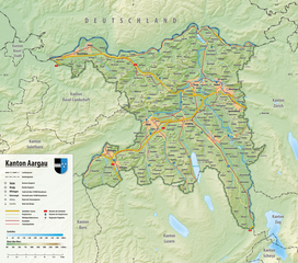
1025:
776:
Click on a date/time to view the file as it appeared at that time.
151:
1093:
338:
This licensing tag was added to this file as part of the GFDL
1083:
1158:
1103:
162:
93:
487:
Add a one-line explanation of what this file represents
83:(2,113 × 1,868 pixels, file size: 4.32 MB, MIME type:
1014:
1074:
774:
673:
Creative
Commons Attribution-ShareAlike 3.0 Unported
605:
579:
Creative
Commons Attribution-ShareAlike 3.0 Unported
563:
223:, Version 1.2 or any later version published by the
117:
Commons is a freely licensed media file repository.
1193:
1168:
656:
Creative
Commons Attribution-ShareAlike 2.5 Generic
639:
Creative
Commons Attribution-ShareAlike 2.0 Generic
622:
Creative
Commons Attribution-ShareAlike 1.0 Generic
575:
Creative
Commons Attribution-ShareAlike 2.5 Generic
571:
Creative
Commons Attribution-ShareAlike 2.0 Generic
567:
Creative Commons Attribution-ShareAlike 1.0 Generic
445:https://creativecommons.org/licenses/by-sa/2.5
345:http://creativecommons.org/licenses/by-sa/3.0/
98:
1184:Module:Location map/data/Canton of Aargau/doc
1149:Module:Location map/data/Canton of Aargau/doc
1134:Module:Location map/data/Canton of Aargau/doc
1066:Module:Location map/data/Canton of Aargau/doc
451:Creative Commons Attribution-Share Alike 2.5
366:
258:
188:
158:
135:
1119:モジュール:Location map/data/Canton of Aargau/doc
351:Creative Commons Attribution-Share Alike 3.0
178:
168:
14:
411:– to copy, distribute and transmit the work
301:– to copy, distribute and transmit the work
463:You may select the license of your choice.
1179:Module:Location map/data/Canton of Aargau
1144:Module:Location map/data/Canton of Aargau
1129:Module:Location map/data/Canton of Aargau
1076:The following other wikis use this file:
1061:Module:Location map/data/Canton of Aargau
1114:モジュール:Location map/data/Canton of Aargau
152:NASA Shuttle Radar Topography Mission
129:
280:Attribution-Share Alike 3.0 Unported
253:
235:http://www.gnu.org/copyleft/fdl.html
1089:Knowledge:Bsunders glungeni Artikel
767:
377:
372:
269:
264:
13:
1204:
492:
486:
462:
363:
202:
142:
130:
76:
1238:
1211:
491:
1015:
477:
422:Under the following conditions:
384:This file is licensed under the
376:
371:
365:
312:Under the following conditions:
275:This file is licensed under the
268:
263:
257:
211:
210:
97:
31:
21:
474:
1125:Usage on simple.wikipedia.org
1071:
771:
473:
241:GNU Free Documentation License
230:GNU Free Documentation License
220:GNU Free Documentation License
148:Reliefkarte des Kantons Aargau
143:
26:
1:
755:original creation by uploader
729:original creation by uploader
150:Topographischer Hintergrund:
36:
1011:
499:Items portrayed in this file
7:
1201:
1080:Usage on als.wikipedia.org
154:(public domain). SRTM3 v.2.
10:
1243:
1190:Usage on www.wikidata.org
1175:Usage on uz.wikipedia.org
1165:Usage on sv.wikipedia.org
1155:Usage on sl.wikipedia.org
1140:Usage on si.wikipedia.org
1110:Usage on ja.wikipedia.org
1100:Usage on de.wikipedia.org
1051:Synagogue of Baden, Aargau
436:same or compatible license
326:same or compatible license
132:
768:
284:
256:
172:
16:
476:
402:
388:Attribution-Share Alike
225:Free Software Foundation
104:This is a file from the
41:
1005:
975:
945:
915:
885:
855:
825:
804:18:29, 26 December 2021
161:
108:. Information from its
864:09:59, 23 January 2019
138:Reliefkarte Aargau.png
111:description page there
46:Size of this preview:
1215:Horizontal resolution
984:14:35, 27 August 2013
954:07:40, 17 April 2015
924:07:42, 17 April 2015
70:2,113 × 1,868 pixels
66:1,158 × 1,024 pixels
1223:Vertical resolution
1041:Linnerberg (Aargau)
834:19:43, 18 July 2020
417:– to adapt the work
307:– to adapt the work
52:Other resolutions:
1031:Klingnauer Stausee
1230:
1229:
1094:Surbtalerjiddisch
1072:Global file usage
1009:
894:14:21, 2 May 2016
589:copyright license
559:copyright license
485:
470:
469:
362:
361:
252:
251:
197:
194:Reusing this file
126:
125:
106:Wikimedia Commons
32:Global file usage
1234:
1212:
1021:Egelsee (Aargau)
996:
966:
936:
906:
876:
846:
816:
778:
529:copyright status
515:copyright status
483:
458:
455:
452:
449:
446:
438:as the original.
386:Creative Commons
380:
379:
375:
374:
369:
368:
358:
355:
352:
349:
346:
343:
340:licensing update
328:as the original.
277:Creative Commons
272:
271:
267:
266:
261:
260:
254:
248:
245:
242:
239:
236:
214:
213:
207:
191:
174:
164:
147:
139:
133:
122:
101:
100:
94:
88:
86:
73:
62:869 × 768 pixels
58:543 × 480 pixels
54:272 × 240 pixels
48:678 × 599 pixels
1242:
1241:
1237:
1236:
1235:
1233:
1232:
1231:
1200:
1070:
1017:
1010:
1002:
994:
972:
964:
942:
934:
912:
904:
882:
874:
852:
844:
822:
814:
770:
769:
766:
765:
764:
763:
762:
761:
760:
759:
757:
745:
744:
743:
741:
722:
721:
720:
719:
718:
717:
716:
715:
713:
703:
702:
701:
699:
684:
683:
682:
681:
680:
679:
678:
677:
675:
664:
663:
662:
661:
660:
658:
647:
646:
645:
644:
643:
641:
630:
629:
628:
627:
626:
624:
613:
612:
611:
610:
609:
607:
595:
594:
593:
591:
556:
555:
554:
553:
552:
551:
550:
549:
547:
535:
534:
533:
531:
512:
511:
510:
509:
508:
506:
490:
489:
488:
471:
466:
465:
464:
460:
459:
456:
453:
450:
447:
444:
443:
401:
381:
356:
353:
350:
347:
344:
337:
246:
243:
240:
237:
234:
205:
204:
149:
137:
128:
127:
116:
115:
114:is shown below.
90:
84:
82:
75:
74:
51:
12:
11:
5:
1240:
1228:
1227:
1224:
1220:
1219:
1216:
1203:
1199:
1198:
1197:
1196:
1188:
1187:
1186:
1181:
1173:
1172:
1171:
1163:
1162:
1161:
1153:
1152:
1151:
1146:
1138:
1137:
1136:
1131:
1123:
1122:
1121:
1116:
1108:
1107:
1106:
1098:
1097:
1096:
1091:
1086:
1073:
1069:
1068:
1063:
1058:
1053:
1048:
1043:
1038:
1033:
1028:
1023:
1013:
1008:
1007:
1004:
1000:
997:
993:2,117 × 1,871
991:
986:
981:
978:
977:
974:
970:
967:
963:2,116 × 1,871
961:
956:
951:
948:
947:
944:
940:
937:
933:2,116 × 1,871
931:
926:
921:
918:
917:
914:
910:
907:
903:2,117 × 1,871
901:
896:
891:
888:
887:
884:
880:
877:
873:2,113 × 1,868
871:
866:
861:
858:
857:
854:
850:
847:
843:2,113 × 1,868
841:
836:
831:
828:
827:
824:
820:
817:
813:2,113 × 1,868
811:
806:
801:
797:
796:
793:
790:
787:
784:
781:
773:
758:
753:
751:
750:
749:
747:
746:
742:
739:source of file
737:
735:
734:
733:
732:
730:
726:
725:source of file
714:
712:27 August 2013
711:
709:
708:
707:
705:
704:
700:
695:
693:
692:
691:
690:
688:
676:
671:
669:
668:
667:
665:
659:
654:
652:
651:
650:
648:
642:
637:
635:
634:
633:
631:
625:
620:
618:
617:
616:
614:
608:
603:
601:
600:
599:
597:
596:
592:
587:
585:
584:
583:
582:
580:
576:
572:
568:
564:
560:
548:
543:
541:
540:
539:
537:
536:
532:
527:
525:
524:
523:
522:
520:
516:
507:
502:
500:
497:
496:
495:
494:
482:
481:
478:
475:
468:
467:
461:
442:
441:
440:
439:
429:
420:
419:
418:
412:
405:You are free:
383:
382:
364:
360:
359:
334:
333:
332:
331:
330:
329:
319:
310:
309:
308:
302:
295:You are free:
290:
289:
286:
285:
283:
273:
250:
249:
215:
201:
200:
198:
186:
185:
180:
176:
175:
170:
166:
165:
163:27 August 2013
160:
156:
155:
140:
131:
124:
123:
102:
92:
91:
45:
40:
39:
34:
29:
24:
19:
9:
6:
4:
3:
2:
1239:
1225:
1222:
1221:
1217:
1214:
1213:
1210:
1207:
1195:
1192:
1191:
1189:
1185:
1182:
1180:
1177:
1176:
1174:
1170:
1167:
1166:
1164:
1160:
1159:Kanton Aargau
1157:
1156:
1154:
1150:
1147:
1145:
1142:
1141:
1139:
1135:
1132:
1130:
1127:
1126:
1124:
1120:
1117:
1115:
1112:
1111:
1109:
1105:
1104:Kanton Aargau
1102:
1101:
1099:
1095:
1092:
1090:
1087:
1085:
1084:Kanton Aargau
1082:
1081:
1079:
1078:
1077:
1067:
1064:
1062:
1059:
1057:
1054:
1052:
1049:
1047:
1044:
1042:
1039:
1037:
1034:
1032:
1029:
1027:
1024:
1022:
1019:
1018:
1003:
998:
992:
990:
987:
985:
982:
980:
979:
973:
968:
962:
960:
957:
955:
952:
950:
949:
943:
938:
932:
930:
927:
925:
922:
920:
919:
913:
908:
902:
900:
897:
895:
892:
890:
889:
883:
878:
872:
870:
867:
865:
862:
860:
859:
853:
848:
842:
840:
837:
835:
832:
830:
829:
823:
818:
812:
810:
807:
805:
802:
799:
798:
794:
791:
788:
785:
782:
780:
779:
777:
756:
752:
740:
736:
710:
698:
694:
674:
670:
657:
653:
640:
636:
623:
619:
606:
602:
590:
586:
546:
542:
530:
526:
505:
501:
498:
479:
472:
448:CC BY-SA 2.5
437:
433:
430:
427:
424:
423:
421:
416:
413:
410:
407:
406:
404:
403:
399:
395:
391:
387:
370:
341:
336:
335:
327:
323:
320:
317:
314:
313:
311:
306:
303:
300:
297:
296:
294:
293:
292:
291:
288:
287:
281:
278:
274:
262:
255:
232:
231:
226:
222:
221:
216:
209:
208:
199:
195:
190:
187:
184:
181:
177:
171:
167:
157:
153:
146:
141:
134:
120:
113:
112:
107:
103:
96:
95:
89:
80:
79:Original file
71:
67:
63:
59:
55:
49:
44:
38:
35:
33:
30:
28:
25:
23:
20:
18:
15:
1208:
1205:
1075:
1046:Salhöhe Pass
1036:Lake Hallwil
775:
772:File history
431:
425:
414:
408:
348:CC BY-SA 3.0
321:
315:
304:
298:
228:
218:
144:
119:You can help
109:
77:
22:File history
545:copyrighted
519:copyrighted
432:share alike
426:attribution
398:1.0 Generic
394:2.0 Generic
390:2.5 Generic
322:share alike
316:attribution
136:Description
1226:118.11 dpc
1218:118.11 dpc
1012:File usage
789:Dimensions
189:Permission
27:File usage
995:(4.54 MB)
965:(4.55 MB)
935:(4.54 MB)
905:(3.24 MB)
875:(4.32 MB)
845:(4.32 MB)
815:(4.32 MB)
786:Thumbnail
783:Date/Time
697:inception
687:inception
282:license.
145:Deutsch:
85:image/png
1202:Metadata
1026:Flachsee
1001:Tschubby
971:Tschubby
941:Tschubby
911:Tschubby
881:Tschubby
851:Tschubby
821:Tschubby
480:Captions
415:to remix
409:to share
400:license.
305:to remix
299:to share
183:Tschubby
173:Own work
37:Metadata
1056:Ägelsee
800:current
795:Comment
504:depicts
484:English
81:
1194:Q11972
1169:Aargau
179:Author
169:Source
792:User
457:true
454:true
396:and
357:true
354:true
247:true
244:true
238:GFDL
159:Date
17:File
392:,
68:|
64:|
60:|
56:|
50:.
342:.
233:.
196:)
192:(
121:.
87:)
72:.
Text is available under the Creative Commons Attribution-ShareAlike License. Additional terms may apply.
