566:"}},"text\/plain":{"en":{"":"inception"}}},"{\"value\":{\"time\":\"+2012-05-21T00:00:00Z\",\"timezone\":0,\"before\":0,\"after\":0,\"precision\":11,\"calendarmodel\":\"http:\\\/\\\/www.wikidata.org\\\/entity\\\/Q1985727\"},\"type\":\"time\"}":{"text\/html":{"en":{"P571":"21 May 2012"}},"text\/plain":{"en":{"P571":"21 May 2012"}}}}": -->
43:
466:
268:
99:
306:
181:
Regierung das Land in
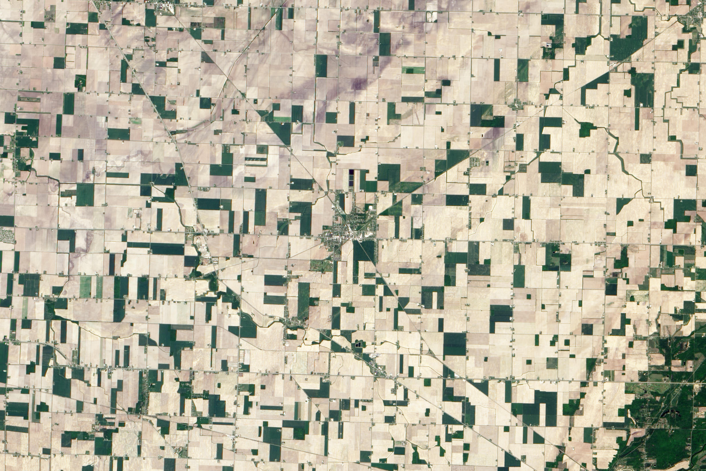
Townships von jeweils sechs Quadratmeilen Fläche ein; die Townships wurde in Flächen unterteilt, die jeweils eine Quadratmeile bzw. 640 Acre umfaßten. Die Vorschrift unterteilte als das Land im Westen in Quadrate und bildete die Grundlage für das Heimstättengesetz von 1865, mit dem öffentliches Land in Eigentum von Bürgern übertragen wurde, wenn diese auf dem Land lebten.
486:"}},"text\/plain":{"en":{"":"determination method"}}},"{\"value\":{\"entity-type\":\"item\",\"numeric-id\":60671452,\"id\":\"Q60671452\"},\"type\":\"wikibase-entityid\"}":{"text\/html":{"en":{"P459":"
482:"}},"text\/plain":{"en":{"P1001":"United States of America"}}},"{\"value\":{\"entity-type\":\"property\",\"numeric-id\":459,\"id\":\"P459\"},\"type\":\"wikibase-entityid\"}":{"text\/html":{"en":{"":"
478:"}},"text\/plain":{"en":{"":"applies to jurisdiction"}}},"{\"value\":{\"entity-type\":\"item\",\"numeric-id\":30,\"id\":\"Q30\"},\"type\":\"wikibase-entityid\"}":{"text\/html":{"en":{"P1001":"
185:
die damaligen
Dampflokomotiven alle 12 bis 15 Kilometer mit Wasser aufgeüllt werden mußten. Die Versorgungsstops wurden zu Knotenpunkten und bildeten Stützpunkte für die Verteilung der Post und dienten der Lagerung von landwirtschaftlichen Gütern, bevor diese verladen und von der Eisenbahn zu den Märkten gebracht wurde. Es entstanden auch Schulen und Kirchen.
470:"}},"text\/plain":{"en":{"":"copyright status"}}},"{\"value\":{\"entity-type\":\"item\",\"numeric-id\":19652,\"id\":\"Q19652\"},\"type\":\"wikibase-entityid\"}":{"text\/html":{"en":{"P6216":"
474:"}},"text\/plain":{"en":{"P6216":"public domain"}}},"{\"value\":{\"entity-type\":\"property\",\"numeric-id\":1001,\"id\":\"P1001\"},\"type\":\"wikibase-entityid\"}":{"text\/html":{"en":{"":"
562:
191:
Reese ist tausend anderen
Kleinstädten ähnlich, die man entlang der Verkehrswege in den Vereinigten Staaten findet. Als das Verkehrsnetz leistungsfähiger wurde, begann der Niedergang der kleinen Städte, und die Dienstleistungen wurden in größere Städten konzentriert. 2010 hatte Reese 1.454 Einwohner,
184:
Die Rest dieser quadratischen
Eigentumsgrenzen sind in dem regelmäßigen Muster der Felder um Reese deutlich erkennbar. Weil die Heimstättenbesitzer auf ihrem Land leben mußten, entstanden an Straßenkreuzungen kleine Versorgungszentren. Später entwickelten sich die Städte entlang der Eisenbahnen, weil
177:
Die kleine Stadt Reese, Michigan, zeigt sich in diesem
Echtfarbenbild als Cluster von weiß und grün an der Kreuzung von zwei Eisenbahnstrecken und einem Highway. Das mit dem Advanced Land Imager (ALI) auf den NASA-Satelliten Earth Observing-1 (EO-1) angefertigte Bild zeigt die Stadt am 21. Mai 2012.
164:
Reese seems to have been settled for all of these reasons. The town was established in 1873 along a new road connecting
Saginaw in the west and Watrousville in the east. The road is the straight line along the lower edge of the town. The railroad also came to the area in 1873, and G.W. Reese was the
188:
Es scheint, daß Reese aus all diesen Gründen besiedelt wurde. Die Stadt wurde 1873 an einer neuen Straße gegründet, die
Saginaw im Westen mit Watrousville im Osten verband. Diese Straße ist die gerade Linie am südlichen (im Bild unteren) Besiedlungsrand der Stadt. Auch die Eisenbahn erreicht in dem
156:
The patterns on display can be traced back to an act of the
Continental Congress. The new nation was expanding and trying to decide how to manage and govern newly settled lands west of the Appalachian Mountains. In the Ordinance of 1785, the young government divided the land into townships of six
160:
The remnants of those square property boundaries are evident in the regular shape of the fields surrounding Reese. Since homesteaders had to live on their property, small supply centers sprung up around crossroads. Later, towns developed along railroads, since trains needed to be resupplied with
180:
Das auf dem Bild sichtbare Muster hat seinen
Ursprung in einem Gesetz des (zweiten) Kontinentalkongresses. Die neugegründete amerikanische Nation expandierte und suchte, wie die neubesiedelten Gebiete westlich der Appalachen zu verwalten und zu regieren seien. In dem Erlaß von 1785 teilte die
167:
Reese is like a thousand other small towns found along transportation lines in the United States. As transportation became more efficient, small towns faded and services were consolidated in larger cities. In 2010, Reese had a population of 1,454, while nearby
Saginaw reached a population of
157:
square miles; townships were subdivided into individual plots measuring one square mile (640 acres) apiece. The act divided western lands into squares and laid the foundation for the Homestead Act of 1865, in which public lands were transferred to private citizens who lived on the land.
153:
The small town of Reese, Michigan, is a cluster of white and green around the crossroads of two railroads and a highway in this true-color image. Acquired by the Advanced Land Imager (ALI) on NASA’s Earth Observing-1 (EO-1) satellite, the image shows the town on May 21, 2012.
659:{{Information |Description ={{en|1=The small town of Reese, Michigan, is a cluster of white and green around the crossroads of two railroads and a highway in this true-color image. Acquired by the Advanced Land Imager (ALI) on NASA’s Earth Observi...
161:
water every eight to ten miles. These supply stops provided way points and hubs for mail delivery and for the storage of farm products (grain, livestock) for shipping to larger markets, stores, schools, and churches.
189:
Jahr den Ort, und G.W. Reese war der Leiter der Bahngesellschaft. Die Stadt wurde schließlich nach ihm benannt und expandierte entlang der Bahnstreke. Heute sitzt ihr Zentrum an der Kreuzung zweier Bahnstrecken.
410:
487:
471:
475:
467:
563:
483:
479:
165:
railroad superintendent. The town became known as Reese and expanded around the railroad, now sitting in the center of the ”X“ formed by the railroad lines.
65:
61:
57:
53:
47:
490:"}},"text\/plain":{"en":{"P459":"work of the federal government of the United States"}}}}": -->
389:
joint project implies that all materials created by its probe are copyrighted and require permission for commercial non-educational use.
78:
338:
110:
548:
229:
704:
This file contains additional information, probably added from the digital camera or scanner used to create or digitize it.
211:
513:
406:
386:
526:
497:
364:
573:
541:
456:
221:
NASA image by Jesse Allen and Robert Simmon using ALI data from the NASA EO-1 team. English caption by Holli Riebeek.
533:
820:
396:
349:
707:
If the file has been modified from its original state, some details may not fully reflect the modified file.
691:
414:
417:
states that all of the images in the photo gallery are in the public domain "Unless otherwise noted."
669:
The following pages on the English Knowledge use this file (pages on other projects are not listed):
641:
636:
69:
42:
360:
118:
390:
345:
8:
401:
377:
371:
212:
http://eoimages.gsfc.nasa.gov/images/imagerecords/82000/82663/reesemi_oli_2012141_lrg.jpg
293:
289:
105:
446:
673:
284:. NASA copyright policy states that "NASA material is not protected by copyright
652:
276:
583:
507:
835:
297:
334:
609:
Click on a date/time to view the file as it appeared at that time.
368:
363:
data may be copyrighted if they are not explicitly produced by the
281:
192:
und die nahe gelegene Stadt Saginaw zählte 51.508 Bewohner.
344:
The NASA website hosts a large number of images from the
201:
93:
440:
Add a one-line explanation of what this file represents
280:
in the United States because it was solely created by
83:(2,465 × 1,644 pixels, file size: 1.26 MB, MIME type:
667:
682:
607:
117:
Commons is a freely licensed media file repository.
549:
work of the federal government of the United States
488:
work of the federal government of the United States
352:, and other non-American space agencies. These are
337:, insignia and emblems is restricted per U.S. law
98:
197:
140:
225:
217:
207:
14:
684:The following other wikis use this file:
864:xmp.did:03EF5BA0F22068118C14C36102B06B64
267:
129:
409:(NSSDC) site has been known to host
400:(APOD) web site may be copyrighted.
262:
230:File:Reese, Michigan (NASA EO-1).tif
600:
13:
702:
445:
439:
407:National Space Science Data Center
315:
304:
171:
147:
130:
76:
876:
709:
444:
668:
430:
266:
97:
31:
21:
853:Date metadata was last modified
821:Adobe Photoshop CS6 (Macintosh)
427:
148:
861:Unique ID of original document
679:
604:
426:
172:
26:
1:
36:
664:
452:Items portrayed in this file
397:Astronomy Picture of the Day
238:
7:
845:Date and time of digitizing
699:
10:
881:
688:Usage on sr.wikipedia.org
294:NASA copyright policy page
143:Reese, Michigan (EO-1).jpg
137:
132:
827:File change date and time
601:
16:
534:United States of America
480:United States of America
429:
104:This is a file from the
41:
856:10:47, 16 December 2013
830:15:47, 16 December 2013
658:
637:12:09, 29 December 2013
527:applies to jurisdiction
476:applies to jurisdiction
394:Images featured on the
200:
108:. Information from its
361:Hubble Space Telescope
320:
309:
111:description page there
46:Size of this preview:
848:11:09, 14 August 2012
793:Horizontal resolution
387:SOHO (ESA & NASA)
356:in the public domain.
319:
308:
785:Number of components
542:determination method
484:determination method
350:Russian space agency
298:JPL Image Use Policy
274:This file is in the
70:2,465 × 1,644 pixels
801:Vertical resolution
411:copyrighted content
359:Materials based on
52:Other resolutions:
761:Compression scheme
743:Bits per component
321:
310:
66:1,280 × 854 pixels
62:1,024 × 683 pixels
868:
867:
769:Pixel composition
680:Global file usage
662:
438:
424:
423:
415:photo gallery FAQ
328:
290:Template:PD-USGov
261:
260:
235:
234:
126:
125:
106:Wikimedia Commons
32:Global file usage
872:
809:Data arrangement
720:
710:
649:
611:
551:
546:
536:
531:
498:copyright status
468:copyright status
436:
380:
374:
324:
318:
307:
270:
269:
263:
257:
254:
251:
248:
243:
242:
203:
176:
152:
144:
138:
122:
101:
100:
94:
88:
86:
73:
58:640 × 427 pixels
54:320 × 213 pixels
48:800 × 534 pixels
880:
879:
875:
874:
873:
871:
870:
869:
764:Deflate (Adobe)
718:
698:
678:
674:Reese, Michigan
670:
663:
655:
647:
603:
602:
599:
598:
597:
596:
595:
594:
593:
592:
590:
580:
579:
578:
576:
561:
560:
559:
558:
557:
556:
555:
554:
553:
552:
547:
544:
538:
537:
532:
529:
520:
519:
518:
516:
504:
503:
502:
500:
465:
464:
463:
462:
461:
459:
443:
442:
441:
420:
378:
372:
354:not necessarily
316:
305:
255:
252:
249:
246:
241:
236:
193:
169:
142:
135:
128:
127:
116:
115:
114:is shown below.
90:
84:
82:
75:
74:
51:
12:
11:
5:
878:
866:
865:
862:
858:
857:
854:
850:
849:
846:
842:
841:
838:
832:
831:
828:
824:
823:
818:
814:
813:
810:
806:
805:
802:
798:
797:
794:
790:
789:
786:
782:
781:
778:
774:
773:
770:
766:
765:
762:
758:
757:
756:
755:
752:
749:
744:
740:
739:
736:
732:
731:
728:
724:
723:
722:
721:
714:
701:
697:
696:
695:
694:
681:
677:
676:
666:
661:
660:
657:
653:
650:
646:2,465 × 1,644
644:
639:
634:
630:
629:
626:
623:
620:
617:
614:
606:
591:
588:
586:
585:
584:
582:
581:
577:
572:
570:
569:
568:
567:
565:
540:
539:
525:
524:
523:
522:
521:
517:
512:
510:
509:
508:
506:
505:
501:
496:
494:
493:
492:
491:
489:
485:
481:
477:
473:
469:
460:
455:
453:
450:
449:
448:
447:
435:
434:
431:
428:
422:
421:
419:
418:
403:
392:
383:
357:
342:
330:
322:
312:
311:
302:
271:
259:
258:
240:
237:
233:
232:
227:
226:Other versions
223:
222:
219:
215:
214:
209:
205:
204:
199:
195:
194:
145:
136:
134:
131:
124:
123:
102:
92:
91:
45:
40:
39:
34:
29:
24:
19:
9:
6:
4:
3:
2:
877:
863:
860:
859:
855:
852:
851:
847:
844:
843:
839:
837:
834:
833:
829:
826:
825:
822:
819:
817:Software used
816:
815:
812:chunky format
811:
808:
807:
803:
800:
799:
795:
792:
791:
787:
784:
783:
779:
776:
775:
771:
768:
767:
763:
760:
759:
753:
750:
747:
746:
745:
742:
741:
737:
734:
733:
729:
726:
725:
719:IDL TIFF file
717:
716:
715:
712:
711:
708:
705:
693:
692:Рис (Мичиген)
690:
689:
687:
686:
685:
675:
672:
671:
656:
651:
645:
643:
640:
638:
635:
632:
631:
627:
624:
621:
618:
615:
613:
612:
610:
587:
575:
571:
550:
543:
535:
528:
515:
514:public domain
511:
499:
495:
472:public domain
458:
454:
451:
432:
425:
416:
412:
408:
404:
402:
399:
398:
393:
391:
388:
384:
381:
379:{{Cc-Hubble}}
375:
373:{{PD-Hubble}}
369:
366:
362:
358:
355:
351:
347:
343:
340:
336:
332:
331:
329:
327:
323:
314:
313:
303:
301:
299:
295:
291:
287:
283:
279:
278:
277:public domain
272:
265:
264:
250:Public domain
247:Public domain
245:
244:
231:
228:
224:
220:
216:
213:
210:
206:
196:
190:
186:
182:
175:
170:
166:
162:
158:
151:
146:
139:
120:
113:
112:
107:
103:
96:
95:
89:
80:
79:Original file
71:
67:
63:
59:
55:
49:
44:
38:
35:
33:
30:
28:
25:
23:
20:
18:
15:
840:Uncalibrated
706:
703:
683:
608:
605:File history
395:
353:
325:
286:unless noted
285:
275:
273:
187:
183:
179:
173:
163:
159:
155:
149:
119:You can help
109:
77:
22:File history
836:Color space
777:Orientation
713:Image title
589:21 May 2012
339:14 CFR 1221
202:21 May 2012
141:Description
665:File usage
622:Dimensions
335:NASA logos
85:image/jpeg
27:File usage
738:10,681 px
654:Matthiasb
648:(1.26 MB)
619:Thumbnail
616:Date/Time
574:inception
564:inception
370:See also
326:Warnings:
239:Licensing
174:Deutsch:
150:English:
730:5,971 px
700:Metadata
433:Captions
288:". (See
37:Metadata
804:100 dpi
796:100 dpi
633:current
628:Comment
457:depicts
437:English
333:Use of
168:51,508.
133:Summary
81:
780:Normal
735:Height
413:. Its
346:Soviet
218:Author
208:Source
727:Width
365:STScI
256:false
253:false
625:User
405:The
385:The
376:and
282:NASA
198:Date
17:File
772:RGB
296:or
754:16
751:16
748:16
545::
530::
300:.)
292:,
68:|
64:|
60:|
56:|
50:.
788:3
382:.
367:.
348:/
341:.
121:.
87:)
72:.
Text is available under the Creative Commons Attribution-ShareAlike License. Additional terms may apply.

.jpg)