562:"}},"text\/plain":{"en":{"":"inception"}}},"{\"value\":{\"time\":\"+2010-09-26T00:00:00Z\",\"timezone\":0,\"before\":0,\"after\":0,\"precision\":11,\"calendarmodel\":\"http:\\\/\\\/www.wikidata.org\\\/entity\\\/Q1985727\"},\"type\":\"time\"}":{"text\/html":{"en":{"P571":"26 September 2010"}},"text\/plain":{"en":{"P571":"26 September 2010"}}}}": -->
253:
38:
259:
264:
94:
518:"}},"text\/plain":{"en":{"":"copyright license"}}},"{\"value\":{\"entity-type\":\"item\",\"numeric-id\":14946043,\"id\":\"Q14946043\"},\"type\":\"wikibase-entityid\"}":{"text\/html":{"en":{"P275":"
474:"}},"text\/plain":{"en":{"":"copyright status"}}},"{\"value\":{\"entity-type\":\"item\",\"numeric-id\":50423863,\"id\":\"Q50423863\"},\"type\":\"wikibase-entityid\"}":{"text\/html":{"en":{"P6216":"
389:"}},"text\/plain":{"en":{"P180":"Wales"}}},"{\"value\":{\"entity-type\":\"item\",\"numeric-id\":156150,\"id\":\"Q156150\"},\"type\":\"wikibase-entityid\"}":{"text\/html":{"en":{"P180":"
393:"}},"text\/plain":{"en":{"P180":"Powys"}}},"{\"value\":{\"entity-type\":\"item\",\"numeric-id\":28575,\"id\":\"Q28575\"},\"type\":\"wikibase-entityid\"}":{"text\/html":{"en":{"P180":"
385:"}},"text\/plain":{"en":{"":"depicts"}}},"{\"value\":{\"entity-type\":\"item\",\"numeric-id\":25,\"id\":\"Q25\"},\"type\":\"wikibase-entityid\"}":{"text\/html":{"en":{"P180":"
470:
311:– You must give appropriate credit, provide a link to the license, and indicate if changes were made. You may do so in any reasonable manner, but not in any way that suggests the licensor endorses you or your use.
659:, UK with the following information shown: *Administrative borders *Coastline, lakes and rivers *Roads and railways *Urban areas Equirectangular map projection on WGS 84 datum, with N/S stretched
519:
475:
390:
394:
471:
559:
515:
382:
386:
1179:
670:
1407:
1516:
522:"}},"text\/plain":{"en":{"P275":"Creative Commons Attribution-ShareAlike 3.0 Unported"}}}}": -->
242:
64:
68:
60:
56:
52:
48:
42:
545:
501:
105:
213:
77:
1397:
440:
318:
1282:
457:
1392:
485:
569:
529:
407:
375:
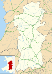
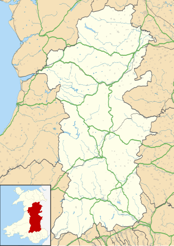
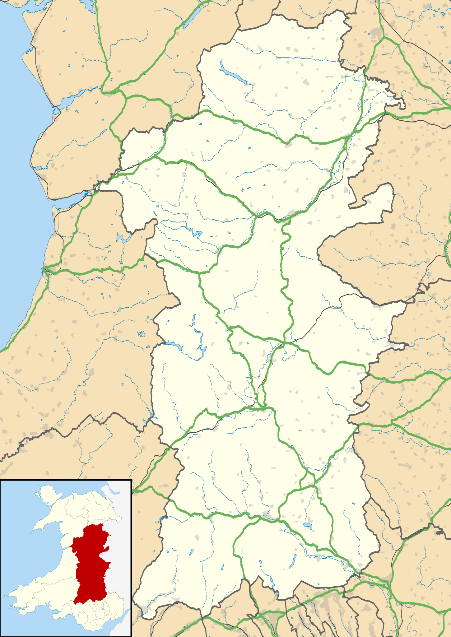
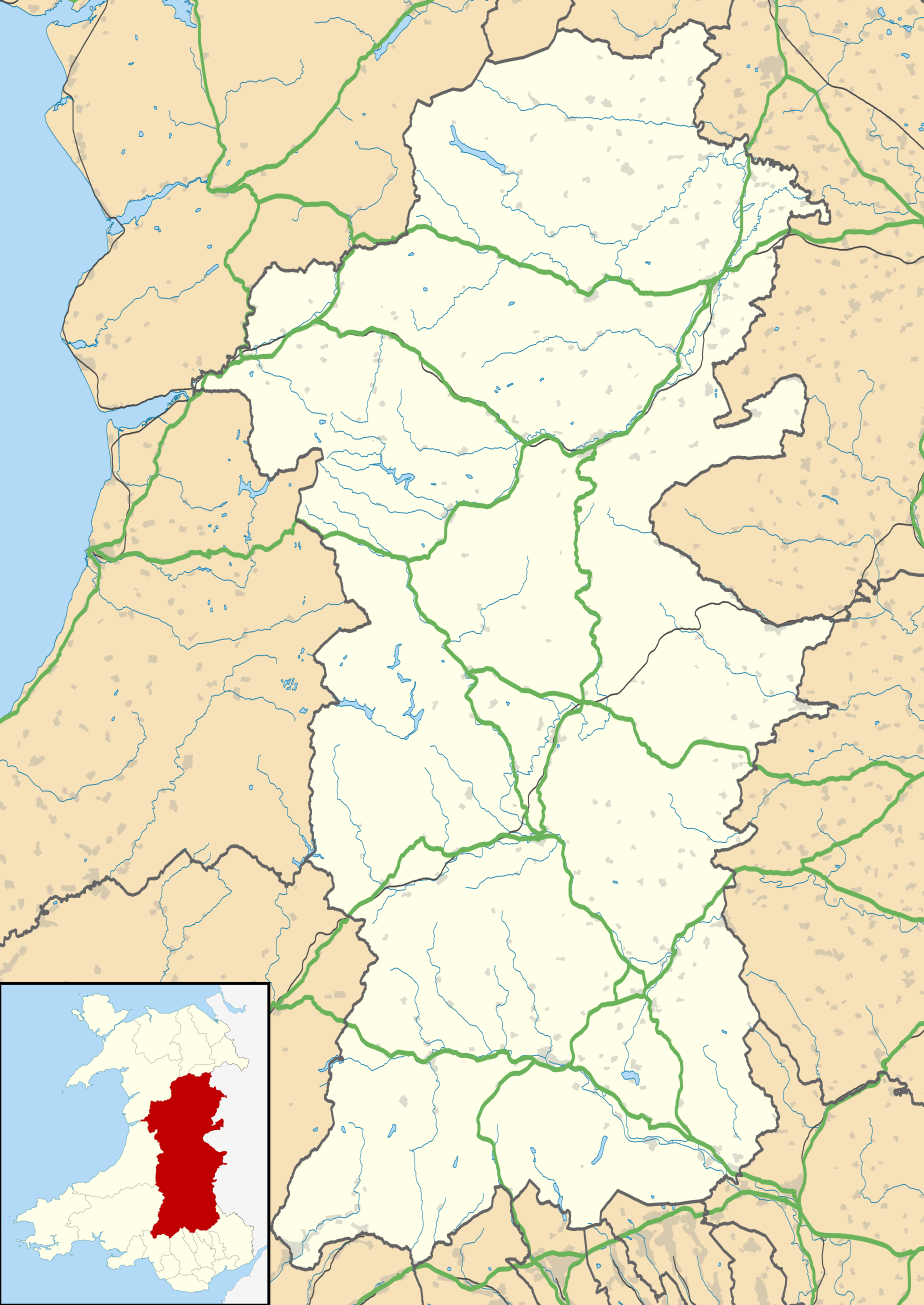
Map of Powys against the wider context of Wales with administritive borders, roads, railways, lakes, and rivers shown
423:
897:
274:
669:
More than 100 pages use this file. The following list shows the first 100 pages that use this file only. A
1332:
317:– If you remix, transform, or build upon the material, you must distribute your contributions under the
982:
862:
478:"}},"text\/plain":{"en":{"P6216":"copyrighted"}}}}": -->
199:
972:
113:
842:
397:"}},"text\/plain":{"en":{"P180":"county"}}}}": -->
351:
1322:
1197:
757:
877:
637:
632:
271:
37:
8:
1287:
937:
1367:
1337:
1042:
217:
1172:
1052:
1047:
922:
712:
100:
1357:
1072:
196:
1242:
1207:
1327:
1162:
1152:
1127:
1007:
887:
747:
737:
230:
1227:
1157:
1082:
1067:
977:
752:
648:
1387:
907:
857:
742:
1342:
1237:
912:
882:
832:
822:
817:
807:
777:
579:
539:
495:
451:
434:
417:
1132:
1112:
1107:
1077:
1027:
1022:
1012:
902:
837:
677:
1457:
159:
Equirectangular map projection on WGS 84 datum, with N/S stretched 165%
1452:
1142:
1117:
1097:
1087:
1062:
1032:
997:
967:
957:
942:
932:
927:
872:
867:
787:
767:
697:
692:
1352:
1167:
1137:
1002:
987:
962:
952:
917:
847:
812:
797:
717:
702:
682:
206:
Administrative borders and coastline data from
Boundary-Line product.
1283:
Wikiproyecto:Ilustración/Taller de
Cartografía/Realizaciones/Europa
1147:
1122:
1102:
992:
947:
892:
782:
772:
727:
722:
707:
605:
Click on a date/time to view the file as it appeared at that time.
282:
Contains
Ordnance Survey data © Crown copyright and database right
1017:
852:
802:
732:
687:
1492:
1487:
1297:
1057:
1037:
762:
139:
1422:
1362:
1312:
1272:
1502:
1447:
1092:
827:
792:
656:
1437:
1292:
82:(SVG file, nominally 924 × 1,305 pixels, file size: 1.75 MB)
1482:
1307:
1467:
1217:
185:
88:
1507:
1497:
1442:
1477:
1472:
1432:
1462:
1302:
667:
1188:
603:
546:
Creative
Commons Attribution-ShareAlike 3.0 Unported
520:
Creative
Commons Attribution-ShareAlike 3.0 Unported
112:
Commons is a freely licensed media file repository.
1427:
1417:
1377:
1277:
1262:
1252:
209:All other geographic data from Meridian 2 product.
328:https://creativecommons.org/licenses/by-sa/3.0
93:
334:Creative Commons Attribution-Share Alike 3.0
252:
237:
181:
130:
347:
226:
191:
14:
294:– to copy, distribute and transmit the work
142:, UK with the following information shown:
41:Size of this PNG preview of this SVG file:
1190:The following other wikis use this file:
655:{{Information |Description=Blank map of
1398:モジュール:Location map/data/Wales Powys/doc
1288:Plantilla:Mapa de localización de Powys
1368:Liste des sites mégalithiques du Powys
1243:Defnyddiwr:AlunWynHalen/Tref-y-clawdd
214:File: United Kingdom location map.svg
124:
275:Attribution-Share Alike 3.0 Unported
233:, created using Ordnance Survey data
1393:モジュール:Location map/data/Wales Powys
596:
263:
258:
13:
1408:ಟೆಂಪ್ಲೇಟು:Location map Wales Powys
1228:Plantilya:Location map Wales Powys
380:
374:
249:
125:
75:
1528:
1388:Template:Location map Wales Powys
379:
898:List of monastic houses in Wales
365:
305:Under the following conditions:
270:This file is licensed under the
262:
257:
251:
92:
31:
21:
362:
1238:Nodyn:Location map Wales Powys
1185:
600:
361:
26:
1:
1323:الگو:Location map Wales Powys
1198:قالب:Location map Wales Powys
1358:Modèle:Géolocalisation/Powys
664:
403:Items portrayed in this file
7:
1224:Usage on ceb.wikipedia.org
1204:Usage on azb.wikipedia.org
149:Coastline, lakes and rivers
10:
1533:
1414:Usage on pl.wikipedia.org
1404:Usage on kn.wikipedia.org
1384:Usage on ja.wikipedia.org
1374:Usage on gv.wikipedia.org
1349:Usage on fr.wikipedia.org
1319:Usage on fa.wikipedia.org
1269:Usage on es.wikipedia.org
1259:Usage on eo.wikipedia.org
1249:Usage on da.wikipedia.org
1234:Usage on cy.wikipedia.org
1214:Usage on ca.wikipedia.org
1194:Usage on ar.wikipedia.org
319:same or compatible license
127:
983:Llansantffraid-ym-Mechain
863:Four Crosses, Llandysilio
597:
133:Powys UK location map.svg
16:
633:19:41, 26 September 2010
364:
285:
99:This is a file from the
36:
973:Llanrhaeadr-ym-Mochnant
654:
184:
103:. Information from its
1458:Moduł:Mapa/dane/GB-POW
843:Criggion Radio Station
146:Administrative borders
106:description page there
1453:Moduł:Mapa/dane/Powys
758:Braichgoch slate mine
352:File:Powys UK map.svg
1353:Cathédrale de Brecon
878:Heartsease, Knighton
65:1,450 × 2,048 pixels
1493:Llanfair Caereinion
938:Llanfair Caereinion
300:– to adapt the work
212:Inset derived from
162:Geographic limits:
47:Other resolutions:
1488:Montgomery (Walia)
1298:Montgomery (Gales)
1043:Mid Wales Hospital
152:Roads and railways
69:924 × 1,305 pixels
61:725 × 1,024 pixels
1517:more global usage
1423:Llandrindod Wells
1363:Llandrindod Wells
1313:Llandrindod Wells
1273:Castillo de Powis
1186:Global file usage
1173:Welshpool Airport
1053:Montgomery Castle
1048:Montgomery, Powys
923:Llandrindod Wells
713:Abertridwr, Powys
662:
585:26 September 2010
530:copyright license
516:copyright license
373:
358:
357:
246:
243:Reusing this file
186:26 September 2010
121:
120:
101:Wikimedia Commons
32:Global file usage
1524:
1503:Knighton (Walia)
1448:Katedra w Brecon
1073:Old Church Stoke
645:
607:
486:copyright status
472:copyright status
371:
341:
338:
335:
332:
329:
321:as the original.
283:
272:Creative Commons
266:
265:
261:
260:
255:
254:
240:
187:
134:
128:
117:
96:
95:
89:
83:
72:
57:544 × 768 pixels
53:340 × 480 pixels
49:170 × 240 pixels
43:424 × 599 pixels
1532:
1531:
1527:
1526:
1525:
1523:
1522:
1521:
1438:Newtown (Powys)
1293:Newtown (Gales)
1184:
1163:Van, Llanidloes
1153:Tretower Castle
1128:Talybont-on-Usk
1008:Llanwrtyd Wells
888:Knighton, Powys
748:Bog snorkelling
738:Bettws Cedewain
663:
651:
643:
599:
598:
595:
594:
593:
592:
591:
590:
589:
588:
586:
576:
575:
574:
572:
557:
556:
555:
554:
553:
552:
551:
550:
548:
536:
535:
534:
532:
513:
512:
511:
510:
509:
508:
507:
506:
504:
492:
491:
490:
488:
469:
468:
467:
466:
465:
464:
463:
462:
460:
449:
448:
447:
446:
445:
443:
432:
431:
430:
429:
428:
426:
414:
413:
412:
410:
378:
377:
376:
359:
343:
342:
339:
336:
333:
330:
327:
326:
284:
281:
278:
267:
197:Ordnance Survey
132:
123:
122:
111:
110:
109:is shown below.
85:
81:
74:
73:
46:
12:
11:
5:
1530:
1519:of this file.
1513:
1512:
1511:
1510:
1505:
1500:
1495:
1490:
1485:
1480:
1475:
1470:
1465:
1460:
1455:
1450:
1445:
1440:
1435:
1430:
1425:
1420:
1412:
1411:
1410:
1402:
1401:
1400:
1395:
1390:
1382:
1381:
1380:
1372:
1371:
1370:
1365:
1360:
1355:
1347:
1346:
1345:
1340:
1335:
1330:
1325:
1317:
1316:
1315:
1310:
1305:
1300:
1295:
1290:
1285:
1280:
1275:
1267:
1266:
1265:
1257:
1256:
1255:
1247:
1246:
1245:
1240:
1232:
1231:
1230:
1222:
1221:
1220:
1212:
1211:
1210:
1202:
1201:
1200:
1187:
1182:to this file.
1176:
1175:
1170:
1165:
1160:
1158:Tretower Court
1155:
1150:
1145:
1140:
1135:
1130:
1125:
1120:
1115:
1110:
1105:
1100:
1095:
1090:
1085:
1083:Pontneddfechan
1080:
1075:
1070:
1068:Newtown, Powys
1065:
1060:
1055:
1050:
1045:
1040:
1035:
1030:
1025:
1020:
1015:
1010:
1005:
1000:
995:
990:
985:
980:
978:Llansantffraed
975:
970:
965:
960:
955:
950:
945:
940:
935:
930:
925:
920:
915:
910:
905:
900:
895:
890:
885:
880:
875:
870:
865:
860:
855:
850:
845:
840:
835:
830:
825:
820:
815:
810:
805:
800:
795:
790:
785:
780:
775:
770:
765:
760:
755:
753:Bont Dolgadfan
750:
745:
740:
735:
730:
725:
720:
715:
710:
705:
700:
695:
690:
685:
680:
673:is available.
666:
661:
660:
653:
649:
646:
640:
635:
630:
626:
625:
622:
619:
616:
613:
610:
602:
587:
584:
582:
581:
580:
578:
577:
573:
568:
566:
565:
564:
563:
561:
549:
544:
542:
541:
540:
538:
537:
533:
528:
526:
525:
524:
523:
521:
517:
505:
500:
498:
497:
496:
494:
493:
489:
484:
482:
481:
480:
479:
477:
473:
461:
456:
454:
453:
452:
450:
444:
439:
437:
436:
435:
433:
427:
422:
420:
419:
418:
416:
415:
411:
406:
404:
401:
400:
399:
398:
396:
392:
388:
384:
370:
369:
366:
363:
356:
355:
349:
348:Other versions
345:
344:
325:
324:
323:
322:
312:
303:
302:
301:
295:
288:You are free:
279:
269:
268:
250:
247:
235:
234:
228:
224:
223:
222:
221:
210:
207:
193:
189:
188:
183:
179:
178:
177:
176:
173:
170:
167:
157:
156:
153:
150:
147:
135:
126:
119:
118:
97:
87:
86:
40:
35:
34:
29:
24:
19:
9:
6:
4:
3:
2:
1529:
1520:
1518:
1509:
1506:
1504:
1501:
1499:
1496:
1494:
1491:
1489:
1486:
1484:
1483:Ystradgynlais
1481:
1479:
1476:
1474:
1471:
1469:
1466:
1464:
1461:
1459:
1456:
1454:
1451:
1449:
1446:
1444:
1441:
1439:
1436:
1434:
1431:
1429:
1426:
1424:
1421:
1419:
1416:
1415:
1413:
1409:
1406:
1405:
1403:
1399:
1396:
1394:
1391:
1389:
1386:
1385:
1383:
1379:
1376:
1375:
1373:
1369:
1366:
1364:
1361:
1359:
1356:
1354:
1351:
1350:
1348:
1344:
1341:
1339:
1336:
1334:
1331:
1329:
1326:
1324:
1321:
1320:
1318:
1314:
1311:
1309:
1308:Ystradgynlais
1306:
1304:
1301:
1299:
1296:
1294:
1291:
1289:
1286:
1284:
1281:
1279:
1276:
1274:
1271:
1270:
1268:
1264:
1261:
1260:
1258:
1254:
1251:
1250:
1248:
1244:
1241:
1239:
1236:
1235:
1233:
1229:
1226:
1225:
1223:
1219:
1216:
1215:
1213:
1209:
1206:
1205:
1203:
1199:
1196:
1195:
1193:
1192:
1191:
1183:
1181:
1174:
1171:
1169:
1166:
1164:
1161:
1159:
1156:
1154:
1151:
1149:
1146:
1144:
1141:
1139:
1136:
1134:
1131:
1129:
1126:
1124:
1121:
1119:
1116:
1114:
1111:
1109:
1106:
1104:
1101:
1099:
1096:
1094:
1091:
1089:
1086:
1084:
1081:
1079:
1076:
1074:
1071:
1069:
1066:
1064:
1061:
1059:
1056:
1054:
1051:
1049:
1046:
1044:
1041:
1039:
1036:
1034:
1031:
1029:
1026:
1024:
1021:
1019:
1016:
1014:
1011:
1009:
1006:
1004:
1001:
999:
996:
994:
991:
989:
986:
984:
981:
979:
976:
974:
971:
969:
966:
964:
961:
959:
956:
954:
951:
949:
946:
944:
941:
939:
936:
934:
931:
929:
926:
924:
921:
919:
916:
914:
911:
909:
908:Llanafan Fawr
906:
904:
901:
899:
896:
894:
891:
889:
886:
884:
881:
879:
876:
874:
871:
869:
866:
864:
861:
859:
858:Esgairgeiliog
856:
854:
851:
849:
846:
844:
841:
839:
836:
834:
831:
829:
826:
824:
821:
819:
816:
814:
811:
809:
806:
804:
801:
799:
796:
794:
791:
789:
786:
784:
781:
779:
776:
774:
771:
769:
766:
764:
761:
759:
756:
754:
751:
749:
746:
744:
743:Beulah, Powys
741:
739:
736:
734:
731:
729:
726:
724:
721:
719:
716:
714:
711:
709:
706:
704:
701:
699:
696:
694:
691:
689:
686:
684:
681:
679:
676:
675:
674:
672:
658:
652:
647:
641:
639:
636:
634:
631:
628:
627:
623:
620:
617:
614:
611:
609:
608:
606:
583:
571:
567:
547:
543:
531:
527:
503:
499:
487:
483:
459:
455:
442:
438:
425:
421:
409:
405:
402:
367:
360:
353:
350:
346:
331:CC BY-SA 3.0
320:
316:
313:
310:
307:
306:
304:
299:
296:
293:
290:
289:
287:
286:
280:Attribution:
276:
273:
256:
248:
244:
239:
236:
232:
229:
225:
219:
215:
211:
208:
205:
204:
203:
201:
198:
194:
190:
180:
175:South: 51.72N
174:
172:North: 52.92N
171:
168:
165:
164:
163:
160:
154:
151:
148:
145:
144:
143:
141:
138:Blank map of
136:
129:
115:
108:
107:
102:
98:
91:
90:
84:
79:
78:Original file
70:
66:
62:
58:
54:
50:
44:
39:
33:
30:
28:
25:
23:
20:
18:
15:
1514:
1468:Builth Wells
1218:Capel-y-ffin
1189:
1177:
913:Llanbrynmair
883:Kerry, Powys
833:Commins Coch
823:Church Stoke
818:Cemmaes Road
808:Capel-y-ffin
778:Builth Wells
668:
642:924 × 1,305
604:
601:File history
314:
308:
297:
291:
218:NordNordWest
195:
161:
158:
137:
114:You can help
104:
76:
22:File history
1508:Machynlleth
1498:Crickhowell
1443:Latham Park
1333:اولد رادنور
1133:Three Cocks
1113:Sennybridge
1108:Sarn, Powys
1078:Pontdolgoch
1028:Machynlleth
1023:MOMA, Wales
1013:Llanymynech
903:Llan, Powys
838:Crickhowell
678:Abbeycwmhir
502:copyrighted
476:copyrighted
354:- Blank map
315:share alike
309:attribution
169:East: 2.82W
166:West: 4.22W
155:Urban areas
131:Description
1478:Llanidloes
1473:Presteigne
1433:Hay-on-Wye
1180:more links
1143:Trefeglwys
1118:Staylittle
1098:Presteigne
1088:Pontrobert
1063:New Radnor
1033:Maen Madoc
998:Llanwrthwl
968:Llanidloes
958:Llangynidr
943:Llanfyllin
933:Llanelwedd
928:Llandrinio
873:Hay Castle
868:Hay-on-Wye
788:Buttington
768:Broneirion
698:Aberhafesp
693:Abergwydol
665:File usage
618:Dimensions
238:Permission
27:File usage
1463:Welshpool
1303:Welshpool
1168:Welshpool
1138:Trecastle
1003:Llanwrtyd
988:Llanwddyn
963:Llangynyw
953:Llangurig
918:Llandinam
848:Derwenlas
813:Cathedine
798:Caehopkin
718:Aberyscir
703:Aberhosan
683:Abercegir
671:full list
650:Nilfanion
644:(1.75 MB)
615:Thumbnail
612:Date/Time
570:inception
560:inception
231:Nilfanion
1148:Tregynon
1123:Talgarth
1103:Rhayader
993:Llanwrin
948:Llangors
893:Knucklas
783:Burgedin
773:Bronllys
728:Beguildy
723:Arddleen
708:Abermule
368:Captions
298:to remix
292:to share
277:license.
200:OpenData
1338:برانلیس
1018:Llanyre
853:Dolanog
803:Caersws
733:Berriew
688:Aberedw
629:current
624:Comment
408:depicts
383:depicts
372:English
80:
1428:Brecon
1328:ولشپول
1208:ولشپول
1058:Morben
1038:Meifod
763:Brecon
458:county
395:county
227:Author
192:Source
1515:View
1418:Powys
1378:Powys
1343:نانمل
1278:Powys
1263:Powys
1253:Powys
1178:View
1093:Powys
828:Clyro
793:Bwlch
657:Powys
441:Powys
424:Wales
391:Powys
387:Wales
140:Powys
621:User
340:true
337:true
182:Date
17:File
216:by
202:.
67:|
63:|
59:|
55:|
51:|
45:.
245:)
241:(
220:.
116:.
71:.
