477:"}},"text\/plain":{"en":{"":"inception"}}},"{\"value\":{\"time\":\"+2010-10-31T00:00:00Z\",\"timezone\":0,\"before\":0,\"after\":0,\"precision\":11,\"calendarmodel\":\"http:\\\/\\\/www.wikidata.org\\\/entity\\\/Q1985727\"},\"type\":\"time\"}":{"text\/html":{"en":{"P571":"31 October 2010"}},"text\/plain":{"en":{"P571":"31 October 2010"}}}}": -->
38:
248:
254:
259:
94:
433:"}},"text\/plain":{"en":{"":"copyright license"}}},"{\"value\":{\"entity-type\":\"item\",\"numeric-id\":14946043,\"id\":\"Q14946043\"},\"type\":\"wikibase-entityid\"}":{"text\/html":{"en":{"P275":"
389:"}},"text\/plain":{"en":{"":"copyright status"}}},"{\"value\":{\"entity-type\":\"item\",\"numeric-id\":50423863,\"id\":\"Q50423863\"},\"type\":\"wikibase-entityid\"}":{"text\/html":{"en":{"P6216":"
385:
306:– You must give appropriate credit, provide a link to the license, and indicate if changes were made. You may do so in any reasonable manner, but not in any way that suggests the licensor endorses you or your use.
574:, Devon, UK with the following information shown: *Administrative borders *Coastline, lakes and rivers *Roads and railways *Urban areas Equirectangular map projection on WGS 84 datum, with N/S stre
434:
390:
386:
474:
430:
686:
628:
623:
437:"}},"text\/plain":{"en":{"P275":"Creative Commons Attribution-ShareAlike 3.0 Unported"}}}}": -->
68:
64:
60:
56:
52:
48:
42:
237:
105:
77:
212:
460:
416:
313:
716:
400:
484:
444:
375:
711:
269:
656:
646:
312:– If you remix, transform, or build upon the material, you must distribute your contributions under the
393:"}},"text\/plain":{"en":{"P6216":"copyrighted"}}}}": -->
584:
The following pages on the
English Knowledge use this file (pages on other projects are not listed):
588:
199:
701:
618:
113:
598:
552:
547:
37:
696:
266:
8:
666:
100:
676:
365:
196:
225:
603:
593:
563:
613:
608:
494:
454:
410:
159:
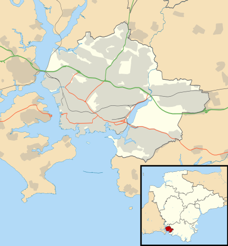
Equirectangular map projection on WGS 84 datum, with N/S stretched 150%
205:
Administrative borders and coastline data from
Boundary-Line product.
139:
571:
520:
Click on a date/time to view the file as it appeared at that time.
277:
Contains
Ordnance Survey data © Crown copyright and database right
82:(SVG file, nominally 1,100 × 1,187 pixels, file size: 573 KB)
717:
Modül:Konum haritası/veri/Birleşik Krallık
Plymouth/belge
185:
88:
359:
Add a one-line explanation of what this file represents
582:
702:
Module:Location map/data/United
Kingdom Plymouth/doc
637:
629:
Module:Location map/data/United
Kingdom Plymouth/doc
518:
461:
Creative
Commons Attribution-ShareAlike 3.0 Unported
435:
Creative
Commons Attribution-ShareAlike 3.0 Unported
112:
Commons is a freely licensed media file repository.
712:
Modül:Konum haritası/veri/Birleşik Krallık
Plymouth
208:All other geographic data from Meridian 2 product.
142:, Devon, UK with the following information shown:
697:Module:Location map/data/United Kingdom Plymouth
624:Module:Location map/data/United Kingdom Plymouth
687:ಟೆಂಪ್ಲೇಟು:Location map United Kingdom Plymouth
323:https://creativecommons.org/licenses/by-sa/3.0
93:
329:Creative Commons Attribution-Share Alike 3.0
247:
232:
181:
130:
221:
191:
14:
289:– to copy, distribute and transmit the work
41:Size of this PNG preview of this SVG file:
657:الگو:Location map United Kingdom Plymouth
647:قالب:Location map United Kingdom Plymouth
639:The following other wikis use this file:
213:File:Devon UK district map (blank).svg
124:
270:Attribution-Share Alike 3.0 Unported
228:, created using Ordnance Survey data
511:
258:
253:
13:
570:{{Information |Description=Map of
364:
358:
244:
125:
75:
730:
363:
583:
349:
300:Under the following conditions:
265:This file is licensed under the
257:
252:
246:
92:
31:
21:
667:Modèle:Géolocalisation/Plymouth
346:
634:
515:
345:
26:
1:
579:
371:Items portrayed in this file
133:Plymouth UK location map.svg
7:
149:Coastline, lakes and rivers
10:
735:
708:Usage on tr.wikipedia.org
693:Usage on si.wikipedia.org
683:Usage on kn.wikipedia.org
673:Usage on he.wikipedia.org
663:Usage on fr.wikipedia.org
653:Usage on fa.wikipedia.org
643:Usage on ar.wikipedia.org
314:same or compatible license
127:
512:
16:
589:Charles Church, Plymouth
348:
280:
99:This is a file from the
36:
619:Talk:Plymouth/Archive 2
569:
184:
103:. Information from its
599:Duke of Cornwall Hotel
548:22:32, 31 October 2010
146:Administrative borders
106:description page there
69:1,100 × 1,187 pixels
65:1,898 × 2,048 pixels
295:– to adapt the work
211:Inset derived from
162:Geographic limits:
47:Other resolutions:
152:Roads and railways
61:949 × 1,024 pixels
635:Global file usage
577:
445:copyright license
431:copyright license
357:
342:
341:
241:
238:Reusing this file
121:
120:
101:Wikimedia Commons
32:Global file usage
726:
560:
522:
401:copyright status
387:copyright status
355:
336:
333:
330:
327:
324:
316:as the original.
278:
267:Creative Commons
261:
260:
256:
255:
250:
249:
235:
187:
134:
128:
117:
96:
95:
89:
83:
72:
57:712 × 768 pixels
53:445 × 480 pixels
49:222 × 240 pixels
43:556 × 600 pixels
734:
733:
729:
728:
727:
725:
724:
723:
633:
585:
578:
566:
558:
514:
513:
510:
509:
508:
507:
506:
505:
504:
503:
501:
500:31 October 2010
491:
490:
489:
487:
472:
471:
470:
469:
468:
467:
466:
465:
463:
451:
450:
449:
447:
428:
427:
426:
425:
424:
423:
422:
421:
419:
407:
406:
405:
403:
384:
383:
382:
381:
380:
378:
362:
361:
360:
343:
338:
337:
334:
331:
328:
325:
322:
321:
279:
276:
273:
262:
197:Ordnance Survey
186:31 October 2010
132:
123:
122:
111:
110:
109:is shown below.
85:
81:
74:
73:
46:
12:
11:
5:
732:
722:
721:
720:
719:
714:
706:
705:
704:
699:
691:
690:
689:
681:
680:
679:
671:
670:
669:
661:
660:
659:
651:
650:
649:
636:
632:
631:
626:
621:
616:
611:
606:
604:Jennycliff Bay
601:
596:
594:Devonport Park
591:
581:
576:
575:
568:
564:
561:
557:1,100 × 1,187
555:
550:
545:
541:
540:
537:
534:
531:
528:
525:
517:
502:
499:
497:
496:
495:
493:
492:
488:
483:
481:
480:
479:
478:
476:
464:
459:
457:
456:
455:
453:
452:
448:
443:
441:
440:
439:
438:
436:
432:
420:
415:
413:
412:
411:
409:
408:
404:
399:
397:
396:
395:
394:
392:
388:
379:
374:
372:
369:
368:
367:
366:
354:
353:
350:
347:
340:
339:
320:
319:
318:
317:
307:
298:
297:
296:
290:
283:You are free:
274:
264:
263:
245:
242:
230:
229:
223:
219:
218:
217:
216:
209:
206:
193:
189:
188:
183:
179:
178:
177:
176:
173:
170:
167:
157:
156:
153:
150:
147:
135:
126:
119:
118:
97:
87:
86:
40:
35:
34:
29:
24:
19:
9:
6:
4:
3:
2:
731:
718:
715:
713:
710:
709:
707:
703:
700:
698:
695:
694:
692:
688:
685:
684:
682:
678:
675:
674:
672:
668:
665:
664:
662:
658:
655:
654:
652:
648:
645:
644:
642:
641:
640:
630:
627:
625:
622:
620:
617:
615:
614:Saltram House
612:
610:
609:Plymouth Dome
607:
605:
602:
600:
597:
595:
592:
590:
587:
586:
573:
567:
562:
556:
554:
551:
549:
546:
543:
542:
538:
535:
532:
529:
526:
524:
523:
521:
498:
486:
482:
462:
458:
446:
442:
418:
414:
402:
398:
377:
373:
370:
351:
344:
326:CC BY-SA 3.0
315:
311:
308:
305:
302:
301:
299:
294:
291:
288:
285:
284:
282:
281:
275:Attribution:
271:
268:
251:
243:
239:
234:
231:
227:
224:
220:
214:
210:
207:
204:
203:
202:
201:
198:
194:
190:
180:
175:South: 50.28N
174:
172:North: 50.46N
171:
168:
165:
164:
163:
160:
154:
151:
148:
145:
144:
143:
141:
136:
129:
115:
108:
107:
102:
98:
91:
90:
84:
79:
78:Original file
70:
66:
62:
58:
54:
50:
44:
39:
33:
30:
28:
25:
23:
20:
18:
15:
677:פלימות'
638:
519:
516:File history
309:
303:
292:
286:
195:
161:
158:
137:
114:You can help
104:
76:
22:File history
417:copyrighted
391:copyrighted
310:share alike
304:attribution
169:East: 4.00W
166:West: 4.25W
155:Urban areas
131:Description
580:File usage
533:Dimensions
233:Permission
27:File usage
565:Nilfanion
530:Thumbnail
527:Date/Time
485:inception
475:inception
226:Nilfanion
572:Plymouth
559:(573 KB)
352:Captions
293:to remix
287:to share
272:license.
200:OpenData
140:Plymouth
544:current
539:Comment
376:depicts
356:English
138:Map of
80:
222:Author
192:Source
536:User
335:true
332:true
182:Date
17:File
67:|
63:|
59:|
55:|
51:|
45:.
240:)
236:(
215:.
116:.
71:.

.svg)