38:
482:"}},"text\/plain":{"en":{"":"inception"}}},"{\"value\":{\"time\":\"+2010-11-29T00:00:00Z\",\"timezone\":0,\"before\":0,\"after\":0,\"precision\":11,\"calendarmodel\":\"http:\\\/\\\/www.wikidata.org\\\/entity\\\/Q1985727\"},\"type\":\"time\"}":{"text\/html":{"en":{"P571":"29 November 2010"}},"text\/plain":{"en":{"P571":"29 November 2010"}}}}": -->
242:
248:
253:
94:
438:"}},"text\/plain":{"en":{"":"copyright license"}}},"{\"value\":{\"entity-type\":\"item\",\"numeric-id\":14946043,\"id\":\"Q14946043\"},\"type\":\"wikibase-entityid\"}":{"text\/html":{"en":{"P275":"
394:"}},"text\/plain":{"en":{"":"copyright status"}}},"{\"value\":{\"entity-type\":\"item\",\"numeric-id\":50423863,\"id\":\"Q50423863\"},\"type\":\"wikibase-entityid\"}":{"text\/html":{"en":{"P6216":"
390:
766:
300:– You must give appropriate credit, provide a link to the license, and indicate if changes were made. You may do so in any reasonable manner, but not in any way that suggests the licensor endorses you or your use.
856:
579:, UK. Equirectangular map projection on WGS 84 datum, with N/S stretched 160% Geographic limits: *West: 1.74W *East: 0.72W *North: 52.19N *South: 51.44N |Source=[[w:Ordnance Survey|Or
439:
395:
716:
391:
826:
479:
435:
683:
60:
56:
52:
48:
42:
678:
105:
73:
442:"}},"text\/plain":{"en":{"P275":"Creative Commons Attribution-ShareAlike 3.0 Unported"}}}}": -->
340:
816:
811:
653:
231:
465:
421:
976:
673:
307:
746:
405:
971:
731:
489:
449:
380:
736:
202:
263:
701:
986:
658:
876:
638:
931:
557:
552:
306:– If you remix, transform, or build upon the material, you must distribute your contributions under the
64:
37:
648:
613:
608:
603:
398:"}},"text\/plain":{"en":{"P6216":"copyrighted"}}}}": -->
1016:
951:
926:
589:
The following pages on the
English Knowledge use this file (pages on other projects are not listed):
185:
113:
1011:
941:
916:
776:
996:
806:
741:
598:
260:
668:
8:
786:
633:
761:
756:
721:
711:
593:
846:
618:
100:
370:
628:
182:
961:
946:
663:
219:
836:
623:
568:
206:
1006:
866:
906:
886:
751:
726:
139:
499:
459:
415:
643:
576:
901:
891:
145:
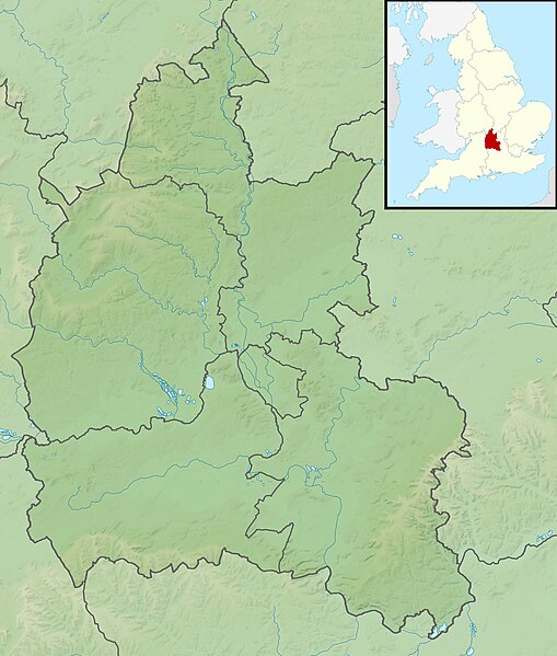
Equirectangular map projection on WGS 84 datum, with N/S stretched 160%
195:
Administrative borders and coastline data from
Boundary-Line product.
525:
Click on a date/time to view the file as it appeared at that time.
791:
271:
Contains
Ordnance Survey data © Crown copyright and database right
796:
977:
Modül:Konum haritası/veri/Birleşik Krallık
Oxfordshire/belge
171:
88:
1017:
Module:Location map/data/United
Kingdom Oxfordshire/doc
952:
Module:Location map/data/United
Kingdom Oxfordshire/doc
932:
Module:Location map/data/United
Kingdom Oxfordshire/doc
684:
Module:Location map/data/United
Kingdom Oxfordshire/doc
364:
Add a one-line explanation of what this file represents
972:
817:モジュール:Location map/data/United Kingdom Oxfordshire/doc
587:
78:(2,003 × 2,357 pixels, file size: 450 KB, MIME type:
692:
523:
466:
Creative
Commons Attribution-ShareAlike 3.0 Unported
440:
Creative Commons Attribution-ShareAlike 3.0 Unported
112:
Commons is a freely licensed media file repository.
1012:
Module:Location map/data/United Kingdom Oxfordshire
942:
Module:Location map/data/United Kingdom Oxfordshire
927:
Module:Location map/data/United Kingdom Oxfordshire
679:
Module:Location map/data/United Kingdom Oxfordshire
812:モジュール:Location map/data/United Kingdom Oxfordshire
198:All other geographic data from Meridian 2 product.
827:ಟೆಂಪ್ಲೇಟು:Location map United Kingdom Oxfordshire
777:Plantilya:Location map United Kingdom Oxfordshire
807:Template:Location map United Kingdom Oxfordshire
997:Batakan:Location map United Kingdom Oxfordshire
987:Bản mẫu:Location map United Kingdom Oxfordshire
917:Šablon:Location map United Kingdom Oxfordshire
317:https://creativecommons.org/licenses/by-sa/3.0
93:
323:Creative Commons Attribution-Share Alike 3.0
241:
226:
167:
130:
702:قالب:Location map United Kingdom Oxfordshire
341:File:Oxfordshire UK district map (blank).svg
336:
215:
192:Relief data from Land-Form Panorama product.
177:
14:
283:– to copy, distribute and transmit the work
654:Mill House and The Wharf, Sutton Courtenay
694:The following other wikis use this file:
575:{{Information |Description=Relief map of
133:Oxfordshire UK relief location map.jpg
962:Mall:Kartposition England Oxfordshire
124:
947:Module:Location map/data/Oxfordshire
674:Module:Location map/data/Oxfordshire
264:Attribution-Share Alike 3.0 Unported
222:, created using Ordnance Survey data
767:Шаблон:ПК Великобритания Оксфордшър
516:
252:
247:
13:
837:Formula:Charta locatrix Oxoniensis
787:Modèle:Géolocalisation/Oxfordshire
369:
363:
238:
125:
71:
1030:
1007:Template:Location map Oxfordshire
867:Sjabloon:Positiekaart Oxfordshire
368:
588:
354:
294:Under the following conditions:
259:This file is licensed under the
251:
246:
240:
92:
31:
21:
351:
923:Usage on simple.wikipedia.org
847:Veidne:VietasKarte Oksfordšīra
689:
520:
350:
26:
1:
659:Redgrave Pinsent Rowing Lake
584:
376:Items portrayed in this file
7:
993:Usage on war.wikipedia.org
907:Moduł:Mapa/dane/Oxfordshire
887:Moduł:Mapa/dane/Oxfordshire
773:Usage on ceb.wikipedia.org
639:Hardwick House, Oxfordshire
10:
1035:
1003:Usage on zh.wikipedia.org
983:Usage on vi.wikipedia.org
968:Usage on tr.wikipedia.org
958:Usage on sv.wikipedia.org
938:Usage on si.wikipedia.org
913:Usage on sh.wikipedia.org
898:Usage on pl.wikibooks.org
883:Usage on pl.wikipedia.org
873:Usage on os.wikipedia.org
863:Usage on nl.wikipedia.org
857:Шаблон:ПолКарта Оксфордшир
853:Usage on mk.wikipedia.org
843:Usage on lv.wikipedia.org
833:Usage on la.wikipedia.org
823:Usage on kn.wikipedia.org
803:Usage on ja.wikipedia.org
783:Usage on fr.wikipedia.org
708:Usage on bg.wikipedia.org
698:Usage on ar.wikipedia.org
308:same or compatible license
127:
649:John Cornwall (died 1414)
614:Chipping Norton Limestone
609:Battle of Cropredy Bridge
604:Battle of Chalgrove Field
517:
16:
353:
274:
203:England location map.svg
99:This is a file from the
36:
574:
553:01:50, 29 November 2011
170:
103:. Information from its
902:Moduł:Mapa/dane/GB-OXF
892:Moduł:Mapa/dane/GB-OXF
797:Tumulus d'Asthall
717:Оксфордски университет
106:description page there
41:Size of this preview:
669:Wayland's Smithy
599:Albert Park, Abingdon
65:2,003 × 2,357 pixels
792:Siège d'Oxford
634:Grimsbury Reservoir
289:– to adapt the work
201:Inset derived from
148:Geographic limits:
47:Other resolutions:
594:Abingdon Reservoir
61:870 × 1,024 pixels
690:Global file usage
619:Farmoor Reservoir
582:
450:copyright license
436:copyright license
362:
347:
346:
235:
232:Reusing this file
121:
120:
101:Wikimedia Commons
32:Global file usage
1026:
629:Garsington Manor
565:
527:
505:29 November 2010
406:copyright status
392:copyright status
360:
330:
327:
324:
321:
318:
310:as the original.
272:
261:Creative Commons
255:
254:
250:
249:
244:
243:
229:
173:
172:29 November 2010
134:
128:
117:
96:
95:
89:
83:
81:
68:
57:653 × 768 pixels
53:408 × 480 pixels
49:204 × 240 pixels
43:509 × 599 pixels
1034:
1033:
1029:
1028:
1027:
1025:
1024:
1023:
747:Удсток (Англия)
688:
664:Siege of Oxford
590:
583:
571:
563:
519:
518:
515:
514:
513:
512:
511:
510:
509:
508:
506:
496:
495:
494:
492:
477:
476:
475:
474:
473:
472:
471:
470:
468:
456:
455:
454:
452:
433:
432:
431:
430:
429:
428:
427:
426:
424:
412:
411:
410:
408:
389:
388:
387:
386:
385:
383:
367:
366:
365:
348:
332:
331:
328:
325:
322:
319:
316:
315:
273:
270:
267:
256:
183:Ordnance Survey
132:
123:
122:
111:
110:
109:is shown below.
85:
79:
77:
70:
69:
46:
12:
11:
5:
1032:
1022:
1021:
1020:
1019:
1014:
1009:
1001:
1000:
999:
991:
990:
989:
981:
980:
979:
974:
966:
965:
964:
956:
955:
954:
949:
944:
936:
935:
934:
929:
921:
920:
919:
911:
910:
909:
904:
896:
895:
894:
889:
881:
880:
879:
871:
870:
869:
861:
860:
859:
851:
850:
849:
841:
840:
839:
831:
830:
829:
821:
820:
819:
814:
809:
801:
800:
799:
794:
789:
781:
780:
779:
771:
770:
769:
764:
759:
754:
749:
744:
739:
734:
729:
724:
719:
714:
706:
705:
704:
691:
687:
686:
681:
676:
671:
666:
661:
656:
651:
646:
641:
636:
631:
626:
624:Fritwell Manor
621:
616:
611:
606:
601:
596:
586:
581:
580:
573:
569:
566:
562:2,003 × 2,357
560:
555:
550:
546:
545:
542:
539:
536:
533:
530:
522:
507:
504:
502:
501:
500:
498:
497:
493:
488:
486:
485:
484:
483:
481:
469:
464:
462:
461:
460:
458:
457:
453:
448:
446:
445:
444:
443:
441:
437:
425:
420:
418:
417:
416:
414:
413:
409:
404:
402:
401:
400:
399:
397:
393:
384:
379:
377:
374:
373:
372:
371:
359:
358:
355:
352:
345:
344:
338:
337:Other versions
334:
333:
314:
313:
312:
311:
301:
292:
291:
290:
284:
277:You are free:
268:
258:
257:
239:
236:
224:
223:
217:
213:
212:
211:
210:
199:
196:
193:
179:
175:
174:
169:
165:
164:
163:
162:
159:
156:
153:
138:Relief map of
135:
126:
119:
118:
97:
87:
86:
40:
35:
34:
29:
24:
19:
9:
6:
4:
3:
2:
1031:
1018:
1015:
1013:
1010:
1008:
1005:
1004:
1002:
998:
995:
994:
992:
988:
985:
984:
982:
978:
975:
973:
970:
969:
967:
963:
960:
959:
957:
953:
950:
948:
945:
943:
940:
939:
937:
933:
930:
928:
925:
924:
922:
918:
915:
914:
912:
908:
905:
903:
900:
899:
897:
893:
890:
888:
885:
884:
882:
878:
875:
874:
872:
868:
865:
864:
862:
858:
855:
854:
852:
848:
845:
844:
842:
838:
835:
834:
832:
828:
825:
824:
822:
818:
815:
813:
810:
808:
805:
804:
802:
798:
795:
793:
790:
788:
785:
784:
782:
778:
775:
774:
772:
768:
765:
763:
760:
758:
755:
753:
750:
748:
745:
743:
740:
738:
737:Хенли он Темз
735:
733:
732:Чипинг Нортън
730:
728:
725:
723:
720:
718:
715:
713:
710:
709:
707:
703:
700:
699:
697:
696:
695:
685:
682:
680:
677:
675:
672:
670:
667:
665:
662:
660:
657:
655:
652:
650:
647:
645:
642:
640:
637:
635:
632:
630:
627:
625:
622:
620:
617:
615:
612:
610:
607:
605:
602:
600:
597:
595:
592:
591:
578:
572:
567:
561:
559:
556:
554:
551:
548:
547:
543:
540:
537:
534:
531:
529:
528:
526:
503:
491:
487:
467:
463:
451:
447:
423:
419:
407:
403:
382:
378:
375:
356:
349:
342:
339:
335:
320:CC BY-SA 3.0
309:
305:
302:
299:
296:
295:
293:
288:
285:
282:
279:
278:
276:
275:
269:Attribution:
265:
262:
245:
237:
233:
228:
225:
221:
218:
214:
208:
204:
200:
197:
194:
191:
190:
189:
187:
184:
180:
176:
166:
161:South: 51.44N
160:
158:North: 52.19N
157:
154:
151:
150:
149:
146:
143:
141:
136:
129:
115:
108:
107:
102:
98:
91:
90:
84:
75:
74:Original file
66:
62:
58:
54:
50:
44:
39:
33:
30:
28:
25:
23:
20:
18:
15:
693:
524:
521:File history
303:
297:
286:
280:
181:
147:
144:
137:
114:You can help
104:
72:
22:File history
644:Henley Park
577:Oxfordshire
422:copyrighted
396:copyrighted
343:- Blank map
304:share alike
298:attribution
155:East: 0.72W
152:West: 1.74W
140:Oxfordshire
131:Description
877:Оксфордшир
585:File usage
538:Dimensions
227:Permission
80:image/jpeg
27:File usage
570:Nilfanion
535:Thumbnail
532:Date/Time
490:inception
480:inception
220:Nilfanion
742:Абингдън
564:(450 KB)
357:Captions
287:to remix
281:to share
266:license.
207:Spischot
186:OpenData
762:Банбъри
757:Бърфорд
722:Джерико
712:Оксфорд
549:current
544:Comment
381:depicts
361:English
76:
216:Author
178:Source
142:, UK.
752:Коули
727:Уитни
541:User
329:true
326:true
168:Date
17:File
205:by
188:.
63:|
59:|
55:|
51:|
45:.
234:)
230:(
209:.
116:.
82:)
67:.

.svg)