778:"}},"text\/plain":{"en":{"":"coordinates of depicted place"}}},"{\"value\":{\"latitude\":53.654,\"longitude\":-1.87,\"altitude\":null,\"precision\":0.001,\"globe\":\"http:\\\/\\\/www.wikidata.org\\\/entity\\\/Q2\"},\"type\":\"globecoordinate\"}":{"text\/html":{"en":{"P9149":"53\u00b039'14"N, 1\u00b052'12"W"}},"text\/plain":{"en":{"P9149":"53\u00b039'14\"N, 1\u00b052'12\"W"}}}}": -->
438:"}},"text\/plain":{"en":{"":"author name string"}}},"{\"value\":\"Mark Mercer\",\"type\":\"string\"}":{"text\/html":{"en":{"P2093":"Mark Mercer"}},"text\/plain":{"en":{"P2093":"Mark Mercer"}}},"{\"value\":{\"entity-type\":\"property\",\"numeric-id\":2699,\"id\":\"P2699\"},\"type\":\"wikibase-entityid\"}":{"text\/html":{"en":{"":"
740:"}},"text\/plain":{"en":{"":"inception"}}},"{\"value\":{\"time\":\"+2005-08-02T00:00:00Z\",\"timezone\":0,\"before\":0,\"after\":0,\"precision\":11,\"calendarmodel\":\"http:\\\/\\\/www.wikidata.org\\\/entity\\\/Q1985727\"},\"type\":\"time\"}":{"text\/html":{"en":{"P571":"2 August 2005"}},"text\/plain":{"en":{"P571":"2 August 2005"}}}}": -->
617:
422:
237:
258:
296:
301:
72:
625:"}},"text\/plain":{"en":{"P7482":"file available on the internet"}}},"{\"value\":{\"entity-type\":\"property\",\"numeric-id\":7384,\"id\":\"P7384\"},\"type\":\"wikibase-entityid\"}":{"text\/html":{"en":{"":"
430:"}},"text\/plain":{"en":{"":"object of statement has role"}}},"{\"value\":{\"entity-type\":\"item\",\"numeric-id\":33231,\"id\":\"Q33231\"},\"type\":\"wikibase-entityid\"}":{"text\/html":{"en":{"P3831":"
641:"}},"text\/plain":{"en":{"P137":"Geograph Britain and Ireland"}}},"{\"value\":{\"entity-type\":\"property\",\"numeric-id\":973,\"id\":\"P973\"},\"type\":\"wikibase-entityid\"}":{"text\/html":{"en":{"":"
577:"}},"text\/plain":{"en":{"":"copyright license"}}},"{\"value\":{\"entity-type\":\"item\",\"numeric-id\":19068220,\"id\":\"Q19068220\"},\"type\":\"wikibase-entityid\"}":{"text\/html":{"en":{"P275":"
533:"}},"text\/plain":{"en":{"":"copyright status"}}},"{\"value\":{\"entity-type\":\"item\",\"numeric-id\":50423863,\"id\":\"Q50423863\"},\"type\":\"wikibase-entityid\"}":{"text\/html":{"en":{"P6216":"
621:"}},"text\/plain":{"en":{"":"source of file"}}},"{\"value\":{\"entity-type\":\"item\",\"numeric-id\":74228490,\"id\":\"Q74228490\"},\"type\":\"wikibase-entityid\"}":{"text\/html":{"en":{"P7482":"
434:"}},"text\/plain":{"en":{"P3831":"photographer"}}},"{\"value\":{\"entity-type\":\"property\",\"numeric-id\":2093,\"id\":\"P2093\"},\"type\":\"wikibase-entityid\"}":{"text\/html":{"en":{"":"
854:
637:"}},"text\/plain":{"en":{"":"operator"}}},"{\"value\":{\"entity-type\":\"item\",\"numeric-id\":1503119,\"id\":\"Q1503119\"},\"type\":\"wikibase-entityid\"}":{"text\/html":{"en":{"P137":"
633:"}},"text\/plain":{"en":{"P7384":"33028"}}},"{\"value\":{\"entity-type\":\"property\",\"numeric-id\":137,\"id\":\"P137\"},\"type\":\"wikibase-entityid\"}":{"text\/html":{"en":{"":"
426:"}},"text\/plain":{"en":{"":"creator"}}},"{\"value\":{\"entity-type\":\"property\",\"numeric-id\":3831,\"id\":\"P3831\"},\"type\":\"wikibase-entityid\"}":{"text\/html":{"en":{"":"
774:
629:"}},"text\/plain":{"en":{"":"geograph.org.uk image ID"}}},"{\"value\":\"33028\",\"type\":\"string\"}":{"text\/html":{"en":{"P7384":"
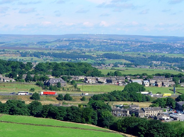
871:== {{int:filedesc}} == {{Information |description={{en|1=Outlane - a linear village. Village of Outlane strung out on A640 alongside M62. Halifax in the distance. Oxenhope Windfarm on the Horizon.}} |date=2005-08-02 |source=From [http://www.geograph.org.u
214:
348:– You must give appropriate credit, provide a link to the license, and indicate if changes were made. You may do so in any reasonable manner, but not in any way that suggests the licensor endorses you or your use.
220:
83:
51:
622:
578:
534:
630:
638:
431:
775:
626:
618:
530:
439:
435:
427:
737:
642:
634:
574:
443:
423:
646:
864:
581:"}},"text\/plain":{"en":{"P275":"Creative Commons Attribution-ShareAlike 2.0 Generic"}}}}": -->
126:
Outlane - a linear village. Village of
Outlane strung out on A640 alongside M62. Halifax in the distance. Oxenhope Windfarm on the Horizon.
446:"}},"text\/plain":{"en":{"P2699":"https:\/\/www.geograph.org.uk\/profile\/1068"}}}}": -->
649:"}},"text\/plain":{"en":{"P973":"https:\/\/www.geograph.org.uk\/photo\/33028"}}}}": -->
672:
604:
560:
230:
707:
265:
936:
This file contains additional information, probably added from the digital camera or scanner used to create or digitize it.
355:
853:
848:
487:
42:
785:
685:
656:
544:
508:
495:
480:
747:
715:
700:
588:
453:
412:
311:
939:
If the file has been modified from its original state, some details may not fully reflect the modified file.
354:– If you remix, transform, or build upon the material, you must distribute your contributions under the
272:
on the
Geograph website for the photographer's contact details. The copyright on this image is owned by
537:"}},"text\/plain":{"en":{"P6216":"copyrighted"}}}}": -->
881:
The following pages on the
English Knowledge use this file (pages on other projects are not listed):
91:
183:
515:
308:
167:
722:
692:
8:
252:
236:
277:
78:
402:
156:
146:
795:
757:
666:
598:
554:
463:
257:
269:
821:
Click on a date/time to view the file as it appeared at that time.
885:
222:
135:
66:
116:
Outlane - a linear village - geograph.org.uk - 33028.jpg
52:
Outlane_-_a_linear_village_-_geograph.org.uk_-_33028.jpg
396:
Add a one-line explanation of what this file represents
923:
879:
913:
903:
894:
819:
90:
Commons is a freely licensed media file repository.
605:
Creative
Commons Attribution-ShareAlike 2.0 Generic
579:
Creative
Commons Attribution-ShareAlike 2.0 Generic
56:(640 × 478 pixels, file size: 104 KB, MIME type:
365:https://creativecommons.org/licenses/by-sa/2.0
71:
371:Creative Commons Attribution-Share Alike 2.0
289:
131:
113:
444:https:\/\/www.geograph.org.uk\/profile\/1068
152:
141:
14:
647:https:\/\/www.geograph.org.uk\/photo\/33028
331:– to copy, distribute and transmit the work
896:The following other wikis use this file:
516:https://www.geograph.org.uk/profile/1068
723:https://www.geograph.org.uk/photo/33028
215:53° 39′ N, 1° 52′ W
229:View this and other nearby images on:
190:
102:
276:and is licensed for reuse under the
205:
812:
312:Attribution-Share Alike 2.0 Generic
300:
295:
280:Attribution-ShareAlike 2.0 license.
13:
934:
401:
395:
286:
263:
120:
103:
49:
960:
941:
400:
880:
386:
342:Under the following conditions:
307:This file is licensed under the
299:
294:
288:
256:
235:
221:
70:
31:
21:
383:
121:
46:No higher resolution available.
891:
816:
673:file available on the internet
623:file available on the internet
382:
264:This image was taken from the
26:
1:
786:coordinates of depicted place
776:coordinates of depicted place
36:
876:
708:Geograph Britain and Ireland
639:Geograph Britain and Ireland
481:object of statement has role
428:object of statement has role
408:Items portrayed in this file
248:
7:
931:
10:
965:
920:Usage on www.wikidata.org
910:Usage on sv.wikipedia.org
900:Usage on fr.wikipedia.org
356:same or compatible license
198:Outlane - a linear village
179:Outlane - a linear village
110:
105:
813:
16:
686:geograph.org.uk image ID
627:geograph.org.uk image ID
385:
322:
196:Mark Mercer /
177:Mark Mercer /
77:This is a file from the
41:
870:
168:required by the license
134:
81:. Information from its
849:16:02, 30 January 2010
270:this photograph's page
241:53.654000; -1.870000
84:description page there
801:53°39'14"N, 1°52'12"W
337:– to adapt the work
496:author name string
436:author name string
952:
951:
892:Global file usage
874:
589:copyright license
575:copyright license
394:
285:
284:
268:collection. See
246:
245:
203:
202:
171:
99:
98:
79:Wikimedia Commons
32:Global file usage
956:
942:
861:
823:
725:
720:
716:described at URL
710:
705:
695:
690:
643:described at URL
545:copyright status
531:copyright status
518:
513:
503:
500:
490:
485:
392:
378:
375:
372:
369:
366:
358:as the original.
320:
309:Creative Commons
303:
302:
298:
297:
292:
291:
278:Creative Commons
266:Geograph project
260:
253:
242:
239:
225:
224:
218:
217:
206:
165:
137:
125:
117:
111:
95:
74:
73:
67:
61:
59:
964:
963:
959:
958:
957:
955:
954:
953:
930:
890:
882:
875:
867:
859:
815:
814:
811:
810:
809:
808:
807:
806:
805:
804:
802:
792:
791:
790:
788:
773:
772:
771:
770:
769:
768:
767:
766:
764:
754:
753:
752:
750:
735:
734:
733:
732:
731:
730:
729:
728:
727:
726:
721:
718:
712:
711:
706:
703:
697:
696:
691:
688:
679:
678:
677:
675:
663:
662:
661:
659:
616:
615:
614:
613:
612:
611:
610:
609:
607:
595:
594:
593:
591:
572:
571:
570:
569:
568:
567:
566:
565:
563:
551:
550:
549:
547:
528:
527:
526:
525:
524:
523:
522:
521:
520:
519:
514:
511:
505:
504:
501:
498:
492:
491:
486:
483:
474:
473:
472:
470:
460:
459:
458:
456:
421:
420:
419:
418:
417:
415:
399:
398:
397:
380:
379:
376:
373:
370:
367:
364:
363:
321:
318:
315:
304:
281:
251:
240:
213:
212:
209:Object location
204:
193:
186:
174:
147:geograph.org.uk
127:
115:
108:
101:
100:
89:
88:
87:is shown below.
63:
57:
55:
48:
47:
12:
11:
5:
962:
950:
949:
946:
933:
929:
928:
927:
926:
918:
917:
916:
908:
907:
906:
893:
889:
888:
878:
873:
872:
869:
865:
862:
856:
851:
846:
842:
841:
838:
835:
832:
829:
826:
818:
803:
800:
798:
797:
796:
794:
793:
789:
784:
782:
781:
780:
779:
777:
765:
762:
760:
759:
758:
756:
755:
751:
746:
744:
743:
742:
741:
739:
714:
713:
699:
698:
684:
683:
682:
681:
680:
676:
671:
669:
668:
667:
665:
664:
660:
657:source of file
655:
653:
652:
651:
650:
648:
644:
640:
636:
632:
628:
624:
620:
619:source of file
608:
603:
601:
600:
599:
597:
596:
592:
587:
585:
584:
583:
582:
580:
576:
564:
559:
557:
556:
555:
553:
552:
548:
543:
541:
540:
539:
538:
536:
532:
507:
506:
494:
493:
479:
478:
477:
476:
475:
471:
468:
466:
465:
464:
462:
461:
457:
452:
450:
449:
448:
447:
445:
441:
437:
433:
429:
425:
416:
411:
409:
406:
405:
404:
403:
391:
390:
387:
384:
362:
361:
360:
359:
349:
340:
339:
338:
332:
325:You are free:
316:
306:
305:
287:
283:
282:
261:
250:
247:
244:
243:
233:
227:
210:
201:
200:
194:
191:
188:
187:
182:
175:
172:
160:
159:
154:
150:
149:
143:
139:
138:
133:
129:
128:
118:
109:
107:
104:
97:
96:
75:
65:
64:
45:
40:
39:
34:
29:
24:
19:
9:
6:
4:
3:
2:
961:
947:
944:
943:
940:
937:
925:
922:
921:
919:
915:
912:
911:
909:
905:
902:
901:
899:
898:
897:
887:
884:
883:
868:
863:
857:
855:
852:
850:
847:
844:
843:
839:
836:
833:
830:
827:
825:
824:
822:
799:
787:
783:
763:2 August 2005
761:
749:
745:
724:
717:
709:
702:
694:
687:
674:
670:
658:
654:
606:
602:
590:
586:
562:
558:
546:
542:
517:
510:
497:
489:
482:
467:
455:
451:
414:
410:
407:
388:
381:
368:CC BY-SA 2.0
357:
353:
350:
347:
344:
343:
341:
336:
333:
330:
327:
326:
324:
323:
317:Attribution:
313:
310:
293:
279:
275:
271:
267:
262:
259:
255:
254:
238:
234:
232:
231:OpenStreetMap
228:
226:
216:
211:
208:
207:
199:
195:
189:
185:
181: /
180:
176:
169:
164:
162:
161:
158:
155:
151:
148:
144:
140:
136:2 August 2005
130:
124:
119:
112:
93:
86:
85:
80:
76:
69:
68:
62:
53:
44:
38:
35:
33:
30:
28:
25:
23:
20:
18:
15:
938:
935:
895:
820:
817:File history
488:photographer
432:photographer
351:
345:
334:
328:
273:
197:
184:CC BY-SA 2.0
178:
122:
92:You can help
82:
50:
22:File history
866:GeographBot
561:copyrighted
535:copyrighted
502:Mark Mercer
352:share alike
346:attribution
319:Mark Mercer
274:Mark Mercer
163:Attribution
157:Mark Mercer
114:Description
945:_error
877:File usage
858:640 × 478
834:Dimensions
469:some value
58:image/jpeg
27:File usage
831:Thumbnail
828:Date/Time
748:inception
738:inception
249:Licensing
192:InfoField
173:InfoField
123:English:
932:Metadata
924:Q7112102
860:(104 KB)
701:operator
635:operator
389:Captions
335:to remix
329:to share
314:license.
37:Metadata
914:Outlane
904:Outlane
886:Outlane
845:current
840:Comment
454:creator
424:creator
413:depicts
393:English
106:Summary
54:
219:
153:Author
142:Source
693:33028
631:33028
145:From
837:User
377:true
374:true
132:Date
17:File
509:URL
440:URL
719::
704::
689::
512::
499::
484::
948:0
170:)
166:(
94:.
60:)
_&language=en)
