229:
151:
72:
279:
43:
114:
525:
355:
430:
83:
51:
588:
This file contains additional information, probably added from the digital camera or scanner used to create or digitize it.
591:
If the file has been modified from its original state, some details may not fully reflect the modified file.
550:
218:
390:
313:
The following pages on the
English Knowledge use this file (pages on other projects are not listed):
505:
289:
91:
278:
273:
42:
500:
8:
327:
172:
using a public domain layer, such as Blue Marble, MODIS, Landsat, SRTM, USGS or GLOBE.
322:
78:
490:
110:
332:
296:
160:
337:
317:
300:
213:
560:
485:
209:
205:
201:
197:
193:
189:
185:
181:
177:
169:
365:
440:
515:
415:
246:
Click on a date/time to view the file as it appeared at that time.
420:
465:
480:
455:
551:
Knowledge:Dagens skandinaviska artikel/Nynorsk/Vecka 22, 2024
545:
400:
165:
535:
391:
Knowledge:Dagens skandinaviske artikel/Nynorsk/Uge 22, 2024
380:
375:
475:
445:
405:
66:
575:
570:
311:
346:
244:
90:
Commons is a freely licensed media file repository.
506:Knowledge:Ukens artikkel på nynorsk/Uke 22, 2024
56:(800 × 593 pixels, file size: 59 KB, MIME type:
71:
14:
348:The following other wikis use this file:
501:Knowledge:Ukens artikkel på nynorsk/2024
491:Knowledge:Utvald artikkel/Veke 22, 2024
150:
102:
144:
13:
586:
227:
103:
49:
612:
593:
312:
164:because it is a screenshot from
149:
70:
31:
21:
46:No higher resolution available.
486:Knowledge:Utvald artikkel/2024
343:
241:
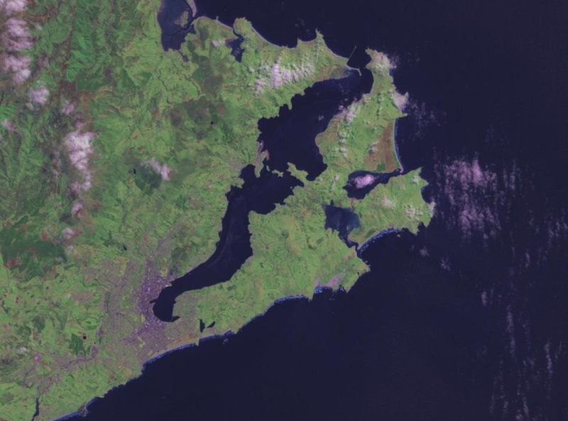
26:
1:
36:
308:
120:
7:
583:
372:Usage on ceb.wikipedia.org
10:
617:
567:Usage on www.wikidata.org
557:Usage on uk.wikipedia.org
542:Usage on sv.wikipedia.org
532:Usage on sl.wikipedia.org
522:Usage on ru.wikipedia.org
512:Usage on pt.wikipedia.org
497:Usage on no.wikipedia.org
472:Usage on nn.wikipedia.org
462:Usage on it.wikipedia.org
452:Usage on id.wikipedia.org
437:Usage on fr.wikipedia.org
427:Usage on fa.wikipedia.org
412:Usage on es.wikipedia.org
397:Usage on eo.wikipedia.org
387:Usage on da.wikipedia.org
362:Usage on az.wikipedia.org
352:Usage on ar.wikipedia.org
105:
52:Otago_harbour_landsat.jpg
16:
77:This is a file from the
41:
295:
81:. Information from its
441:Péninsule d'Otago
232:
84:description page there
274:11:23, 31 August 2007
231:
158:This image is in the
466:Lista delle penisole
526:Отаго (полуостров)
516:Península de Otago
416:Península de Otago
328:List of peninsulas
233:
168:’s globe software
604:
603:
456:Semenanjung Otago
356:قائمة أشباه الجزر
344:Global file usage
323:List of isthmuses
306:
299:landsat image of
238:
237:
221:
143:
142:
113:landsat image of
99:
98:
79:Wikimedia Commons
32:Global file usage
608:
594:
431:شبه جزیره اوتاگو
421:Anexo:Penínsulas
401:Duoninsulo Otago
366:Otaqo yarımadası
291:Manuel Anastácio
286:
248:
230:
222:
217:
153:
152:
145:
139:
136:
133:
130:
125:
124:
95:
74:
73:
67:
61:
59:
616:
615:
611:
610:
609:
607:
606:
605:
582:
536:Otago (polotok)
342:
333:Otago Peninsula
314:
307:
297:NASA World Wind
292:
284:
240:
239:
234:
228:
176:
154:
137:
134:
131:
128:
123:
111:NASA World Wind
108:
101:
100:
89:
88:
87:is shown below.
63:
57:
55:
48:
47:
12:
11:
5:
614:
602:
601:
598:
585:
581:
580:
579:
578:
573:
565:
564:
563:
555:
554:
553:
548:
540:
539:
538:
530:
529:
528:
520:
519:
518:
510:
509:
508:
503:
495:
494:
493:
488:
483:
478:
470:
469:
468:
460:
459:
458:
450:
449:
448:
443:
435:
434:
433:
425:
424:
423:
418:
410:
409:
408:
403:
395:
394:
393:
385:
384:
383:
378:
370:
369:
368:
360:
359:
358:
345:
341:
340:
335:
330:
325:
320:
310:
305:
304:
294:
290:
287:
281:
276:
271:
267:
266:
263:
260:
257:
254:
251:
243:
236:
235:
226:
224:
155:
148:
141:
140:
122:
119:
107:
104:
97:
96:
75:
65:
64:
45:
40:
39:
34:
29:
24:
19:
9:
6:
4:
3:
2:
613:
599:
596:
595:
592:
589:
577:
574:
572:
569:
568:
566:
562:
559:
558:
556:
552:
549:
547:
544:
543:
541:
537:
534:
533:
531:
527:
524:
523:
521:
517:
514:
513:
511:
507:
504:
502:
499:
498:
496:
492:
489:
487:
484:
482:
481:Otago-halvøya
479:
477:
476:Otago Harbour
474:
473:
471:
467:
464:
463:
461:
457:
454:
453:
451:
447:
446:Hoopers Inlet
444:
442:
439:
438:
436:
432:
429:
428:
426:
422:
419:
417:
414:
413:
411:
407:
404:
402:
399:
398:
396:
392:
389:
388:
386:
382:
381:Otago Harbour
379:
377:
376:Hoopers Inlet
374:
373:
371:
367:
364:
363:
361:
357:
354:
353:
351:
350:
349:
339:
338:Papanui Inlet
336:
334:
331:
329:
326:
324:
321:
319:
318:Hoopers Inlet
316:
315:
302:
301:Otago Harbour
298:
293:
288:
282:
280:
277:
275:
272:
269:
268:
264:
261:
258:
255:
252:
250:
249:
247:
225:
223:
220:
215:
211:
207:
203:
199:
195:
191:
187:
183:
179:
174:
173:
171:
167:
163:
162:
161:public domain
156:
147:
146:
132:Public domain
129:Public domain
127:
126:
118:
116:
115:Otago Harbour
112:
93:
86:
85:
80:
76:
69:
68:
62:
53:
44:
38:
35:
33:
30:
28:
25:
23:
20:
18:
15:
590:
587:
406:Haveno Otago
347:
245:
242:File history
175:
159:
157:
109:
92:You can help
82:
50:
22:File history
546:Otagohalvön
597:_error
309:File usage
283:800 × 593
259:Dimensions
206:Nederlands
198:македонски
170:World Wind
58:image/jpeg
27:File usage
576:Q17051442
256:Thumbnail
253:Date/Time
214:中文(中国大陆)
178:العربيَّة
121:Licensing
584:Metadata
571:Q2036651
216: |
212: |
208: |
204: |
200: |
196: |
192: |
190:français
188: |
184: |
180: |
37:Metadata
285:(59 KB)
270:current
265:Comment
210:русский
182:English
106:Summary
54:
202:മലയാളം
561:Отаго
194:עברית
186:فارسی
138:false
135:false
262:User
166:NASA
17:File
219:+/−
117:.
600:0
303:.
94:.
60:)
Text is available under the Creative Commons Attribution-ShareAlike License. Additional terms may apply.