43:
515:"}},"text\/plain":{"en":{"":"inception"}}},"{\"value\":{\"time\":\"+2018-11-04T00:00:00Z\",\"timezone\":0,\"before\":0,\"after\":0,\"precision\":11,\"calendarmodel\":\"http:\\\/\\\/www.wikidata.org\\\/entity\\\/Q1985727\"},\"type\":\"time\"}":{"text\/html":{"en":{"P571":"4 November 2018"}},"text\/plain":{"en":{"P571":"4 November 2018"}}}}": -->
292:
246:
298:
303:
99:
471:"}},"text\/plain":{"en":{"":"copyright license"}}},"{\"value\":{\"entity-type\":\"item\",\"numeric-id\":14946043,\"id\":\"Q14946043\"},\"type\":\"wikibase-entityid\"}":{"text\/html":{"en":{"P275":"
427:"}},"text\/plain":{"en":{"":"copyright status"}}},"{\"value\":{\"entity-type\":\"item\",\"numeric-id\":50423863,\"id\":\"Q50423863\"},\"type\":\"wikibase-entityid\"}":{"text\/html":{"en":{"P6216":"
423:
344:– You must give appropriate credit, provide a link to the license, and indicate if changes were made. You may do so in any reasonable manner, but not in any way that suggests the licensor endorses you or your use.
690:
265:
The ODbL does not require any particular license for maps produced from ODbL data. Prior to 1 August 2020, map tiles produced by the OpenStreetMap
Foundation were licensed under the
620:
617:
472:
428:
424:
512:
468:
69:
65:
61:
73:
57:
53:
47:
608:{{Information |Description={{en|Map of the {{w|National Blue Trail}}, Hungary}} {{hu|Az {{w|Országos Kéktúra|3=hu}} téképe}} |Source={{own}}, using *
601:
222:
475:"}},"text\/plain":{"en":{"P275":"Creative Commons Attribution-ShareAlike 3.0 Unported"}}}}": -->
110:
82:
233:
498:
454:
743:
This file contains additional information, probably added from the digital camera or scanner used to create or digitize it.
351:
616:
data () |Date=2018-11-04 |Author={{u|Földhegy}} |Permission={{ODbL OpenStreetMap}} {{CC-BY-SA-3.0}} |other_versions= }}
438:
522:
482:
413:
196:
313:
609:
746:
If the file has been modified from its original state, some details may not fully reflect the modified file.
590:
585:
42:
350:– If you remix, transform, or build upon the material, you must distribute your contributions under the
166:
431:"}},"text\/plain":{"en":{"P6216":"copyrighted"}}}}": -->
633:
The following pages on the
English Knowledge use this file (pages on other projects are not listed):
118:
310:
154:
8:
637:
105:
403:
266:
258:
209:
205:
670:
613:
200:
720:
680:
655:
532:
492:
448:
245:
710:
665:
240:
700:
558:
Click on a date/time to view the file as it appeared at that time.
269:. Maps produced by other people may be subject to other licences.
254:
87:(SVG file, nominally 951 × 587 pixels, file size: 1.89 MB)
178:
93:
397:
Add a one-line explanation of what this file represents
631:
646:
556:
499:
Creative
Commons Attribution-ShareAlike 3.0 Unported
473:
Creative
Commons Attribution-ShareAlike 3.0 Unported
117:
Commons is a freely licensed media file repository.
730:
361:https://creativecommons.org/licenses/by-sa/3.0
98:
367:Creative Commons Attribution-Share Alike 3.0
291:
278:http://opendatacommons.org/licenses/odbl/1.0/
228:
174:
140:
218:
184:
14:
327:– to copy, distribute and transmit the work
46:Size of this PNG preview of this SVG file:
648:The following other wikis use this file:
129:
314:Attribution-Share Alike 3.0 Unported
257:, which is made available under the
253:This work contains information from
549:
302:
297:
13:
741:
402:
396:
288:
159:
147:
130:
80:
783:
748:
401:
160:
632:
387:
338:Under the following conditions:
309:This file is licensed under the
301:
296:
290:
244:
97:
31:
21:
721:Ulusal Mavi Parkur (Macaristan)
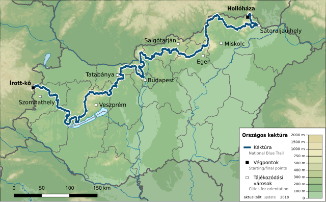
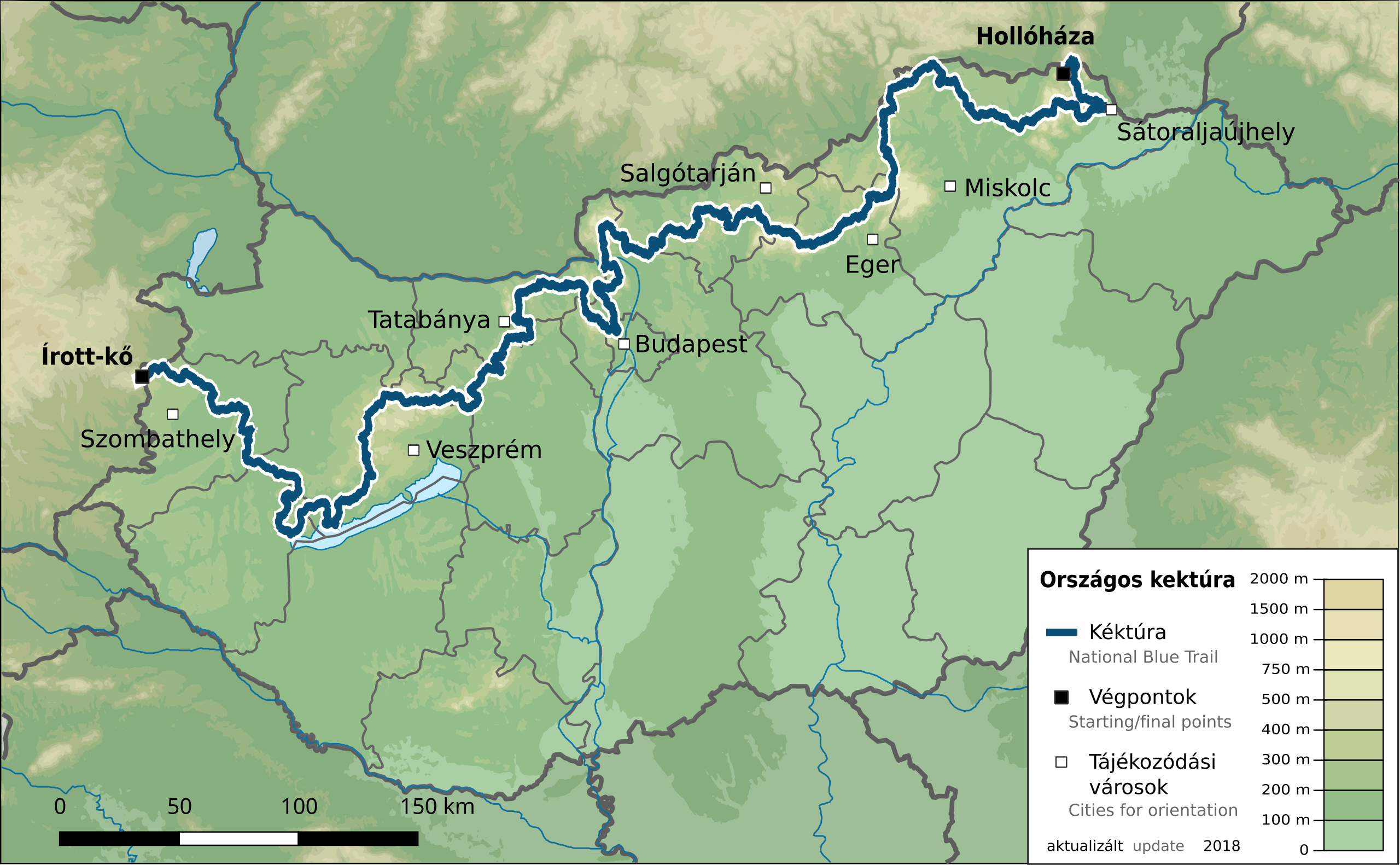
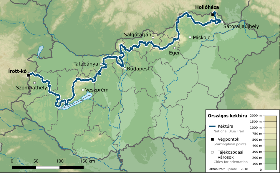
384:
148:
643:
553:
383:
26:
1:
610:File:Hungary physical map.svg
197:File:Hungary physical map.svg
36:
628:
621:Category:National Blue Trail
618:Category:SVG maps of Hungary
409:Items portrayed in this file
259:Open Database License (ODbL)
243:
7:
738:
691:Կապույտ երթուղի (Հունգարիա)
671:Modèle:Infobox Sentier/Test
623:[[Category:Hiking maps o...
10:
788:
727:Usage on www.wikidata.org
717:Usage on tr.wikipedia.org
707:Usage on sl.wikipedia.org
697:Usage on it.wikipedia.org
687:Usage on hy.wikipedia.org
677:Usage on hu.wikipedia.org
662:Usage on fr.wikipedia.org
652:Usage on de.wikipedia.org
352:same or compatible license
137:
132:
550:
189:
16:
386:
318:
143:Országos Kéktúra map.svg
104:This is a file from the
41:
711:Nacionalna Modra pot E4
666:Sentier bleu de Hongrie
607:
177:
108:. Information from its
701:Sentiero blu nazionale
586:18:48, 4 November 2018
111:description page there
272:Open Database License
267:CC-BY-SA-2.0 license
70:2,560 × 1,580 pixels
638:National Blue Trail
612:by {{u|Urutseg}} *
333:– to adapt the work
155:National Blue Trail
52:Other resolutions:
66:1,280 × 790 pixels
62:1,024 × 632 pixels
775:
774:
755:Generated with Qt
644:Global file usage
626:
483:copyright license
469:copyright license
395:
380:
379:
287:
286:
270:
237:
234:Reusing this file
126:
125:
106:Wikimedia Commons
32:Global file usage
779:
749:
681:Országos Kéktúra
656:Országos Kéktúra
598:
560:
439:copyright status
425:copyright status
393:
374:
371:
368:
365:
362:
354:as the original.
311:Creative Commons
305:
304:
300:
299:
294:
293:
282:
279:
276:
273:
264:
248:
241:
231:
210:relation 3020505
191:
180:
167:Országos Kéktúra
164:
152:
144:
138:
122:
101:
100:
94:
88:
77:
74:951 × 587 pixels
58:640 × 395 pixels
54:320 × 198 pixels
48:800 × 494 pixels
787:
786:
782:
781:
780:
778:
777:
776:
737:
642:
634:
627:
604:
596:
552:
551:
548:
547:
546:
545:
544:
543:
542:
541:
539:
538:4 November 2018
529:
528:
527:
525:
510:
509:
508:
507:
506:
505:
504:
503:
501:
489:
488:
487:
485:
466:
465:
464:
463:
462:
461:
460:
459:
457:
445:
444:
443:
441:
422:
421:
420:
419:
418:
416:
400:
399:
398:
381:
376:
375:
372:
369:
366:
363:
360:
359:
317:
306:
280:
277:
274:
271:
179:4 November 2018
170:
158:
142:
135:
128:
127:
116:
115:
114:is shown below.
90:
86:
79:
78:
51:
12:
11:
5:
785:
773:
772:
769:
765:
764:
761:
757:
756:
753:
740:
736:
735:
734:
733:
725:
724:
723:
715:
714:
713:
705:
704:
703:
695:
694:
693:
685:
684:
683:
675:
674:
673:
668:
660:
659:
658:
645:
641:
640:
630:
625:
624:
606:
602:
599:
593:
588:
583:
579:
578:
575:
572:
569:
566:
563:
555:
540:
537:
535:
534:
533:
531:
530:
526:
521:
519:
518:
517:
516:
514:
502:
497:
495:
494:
493:
491:
490:
486:
481:
479:
478:
477:
476:
474:
470:
458:
453:
451:
450:
449:
447:
446:
442:
437:
435:
434:
433:
432:
430:
426:
417:
412:
410:
407:
406:
405:
404:
392:
391:
388:
385:
378:
377:
358:
357:
356:
355:
345:
336:
335:
334:
328:
321:You are free:
308:
307:
289:
285:
284:
251:
249:
238:
226:
225:
220:
216:
215:
214:
213:
203:
186:
182:
181:
176:
172:
171:
145:
136:
134:
131:
124:
123:
102:
92:
91:
45:
40:
39:
34:
29:
24:
19:
9:
6:
4:
3:
2:
784:
770:
767:
766:
762:
759:
758:
754:
751:
750:
747:
744:
732:
729:
728:
726:
722:
719:
718:
716:
712:
709:
708:
706:
702:
699:
698:
696:
692:
689:
688:
686:
682:
679:
678:
676:
672:
669:
667:
664:
663:
661:
657:
654:
653:
651:
650:
649:
639:
636:
635:
622:
619:
615:
614:OpenStreetMap
611:
605:
600:
594:
592:
589:
587:
584:
581:
580:
576:
573:
570:
567:
564:
562:
561:
559:
536:
524:
520:
500:
496:
484:
480:
456:
452:
440:
436:
415:
411:
408:
389:
382:
364:CC BY-SA 3.0
353:
349:
346:
343:
340:
339:
337:
332:
329:
326:
323:
322:
320:
319:
315:
312:
295:
283:
268:
262:
260:
256:
255:OpenStreetMap
252:
250:
247:
242:
239:
235:
230:
227:
224:
221:
217:
211:
207:
206:OpenStreetMap
204:
202:
198:
195:
194:
193:
187:
183:
173:
168:
163:
156:
151:
146:
139:
120:
113:
112:
107:
103:
96:
95:
89:
84:
83:Original file
75:
71:
67:
63:
59:
55:
49:
44:
38:
35:
33:
30:
28:
25:
23:
20:
18:
15:
745:
742:
647:
557:
554:File history
347:
341:
330:
324:
263:
188:
161:
149:
119:You can help
109:
81:
22:File history
771:165.65668mm
763:268.28046mm
752:Image title
455:copyrighted
429:copyrighted
348:share alike
342:attribution
153:Map of the
141:Description
629:File usage
595:951 × 587
571:Dimensions
229:Permission
27:File usage
597:(1.89 MB)
568:Thumbnail
565:Date/Time
523:inception
513:inception
157:, Hungary
150:English:
739:Metadata
603:Földhegy
390:Captions
331:to remix
325:to share
316:license.
223:Földhegy
192:, using
190:Own work
162:Magyar:
37:Metadata
582:current
577:Comment
414:depicts
394:English
201:Urutseg
133:Summary
85:
768:Height
731:Q60088
219:Author
208:data (
185:Source
169:téképe
760:Width
574:User
373:true
370:true
281:true
275:ODbL
175:Date
17:File
199:by
165:Az
261:.
72:|
68:|
64:|
60:|
56:|
50:.
236:)
232:(
212:)
121:.
76:.
Text is available under the Creative Commons Attribution-ShareAlike License. Additional terms may apply.
