43:
489:"}},"text\/plain":{"en":{"":"inception"}}},"{\"value\":{\"time\":\"+2011-02-09T00:00:00Z\",\"timezone\":0,\"before\":0,\"after\":0,\"precision\":11,\"calendarmodel\":\"http:\\\/\\\/www.wikidata.org\\\/entity\\\/Q1985727\"},\"type\":\"time\"}":{"text\/html":{"en":{"P571":"9 February 2011"}},"text\/plain":{"en":{"P571":"9 February 2011"}}}}": -->
235:
241:
246:
99:
527:"}},"text\/plain":{"en":{"":"media type"}}},"{\"value\":\"image\\\/svg+xml\",\"type\":\"string\"}":{"text\/html":{"en":{"P1163":"image\/svg+xml"}},"text\/plain":{"en":{"P1163":"image\/svg+xml"}}}}": -->
445:"}},"text\/plain":{"en":{"":"copyright license"}}},"{\"value\":{\"entity-type\":\"item\",\"numeric-id\":14946043,\"id\":\"Q14946043\"},\"type\":\"wikibase-entityid\"}":{"text\/html":{"en":{"P275":"
401:"}},"text\/plain":{"en":{"":"copyright status"}}},"{\"value\":{\"entity-type\":\"item\",\"numeric-id\":50423863,\"id\":\"Q50423863\"},\"type\":\"wikibase-entityid\"}":{"text\/html":{"en":{"P6216":"
633:
523:
287:– You must give appropriate credit, provide a link to the license, and indicate if changes were made. You may do so in any reasonable manner, but not in any way that suggests the licensor endorses you or your use.
342:{{Information |Description= {{de|Positionskarte der ]}} Quadratische Plattkarte, N-S-Streckung 120 %. Geographische Begrenzung der Karte: * N: 49.8° N * S: 24.2° N * W: 125.5° W
446:
402:
524:
398:
486:
442:
73:
69:
65:
61:
57:
53:
47:
110:
82:
449:"}},"text\/plain":{"en":{"P275":"Creative Commons Attribution-ShareAlike 3.0 Unported"}}}}": -->
632:
627:
472:
428:
748:
This file contains additional information, probably added from the digital camera or scanner used to create or digitize it.
294:
534:
412:
496:
456:
387:
735:
256:
751:
If the file has been modified from its original state, some details may not fully reflect the modified file.
677:
602:
597:
293:– If you remix, transform, or build upon the material, you must distribute your contributions under the
42:
330:
204:
187:
658:
overlayed. Equirectangular projection, N/S stretching 120 %. Geographic limits of the map: * N: 49.8°
405:"}},"text\/plain":{"en":{"P6216":"copyrighted"}}}}": -->
668:
The following pages on the
English Knowledge use this file (pages on other projects are not listed):
118:
151:
overlayed. Equirectangular projection, N/S stretching 120 %. Geographic limits of the map:
351:
148:
253:
218:
8:
672:
655:
337:
208:
105:
377:
192:
North
Country Trail Association GIS, processed with ogr2ogr, OpenJUMP and Inkscape.
214:
144:
643:
613:
651:
544:
506:
466:
422:
715:
570:
Click on a date/time to view the file as it appeared at that time.
705:
695:
174:
87:(SVG file, nominally 1,859 × 968 pixels, file size: 691 KB)
93:
326:
This image is a derivative work of the following image:
371:
Add a one-line explanation of what this file represents
725:
666:
686:
568:
473:
Creative
Commons Attribution-ShareAlike 3.0 Unported
447:
Creative
Commons Attribution-ShareAlike 3.0 Unported
117:
Commons is a freely licensed media file repository.
650:{{Information |Description=Locator map of the
304:https://creativecommons.org/licenses/by-sa/3.0
98:
310:Creative Commons Attribution-Share Alike 3.0
234:
170:
135:
198:
181:
14:
270:– to copy, distribute and transmit the work
46:Size of this PNG preview of this SVG file:
688:The following other wikis use this file:
321:
138:North Country Trail Locator Map US.svg
129:
257:Attribution-Share Alike 3.0 Unported
561:
245:
240:
13:
746:
376:
370:
231:
130:
80:
780:
753:
375:
333:licensed with Cc-by-sa-3.0, GFDL
667:
654:("lower 48") with the
361:
281:Under the following conditions:
252:This file is licensed under the
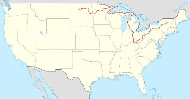
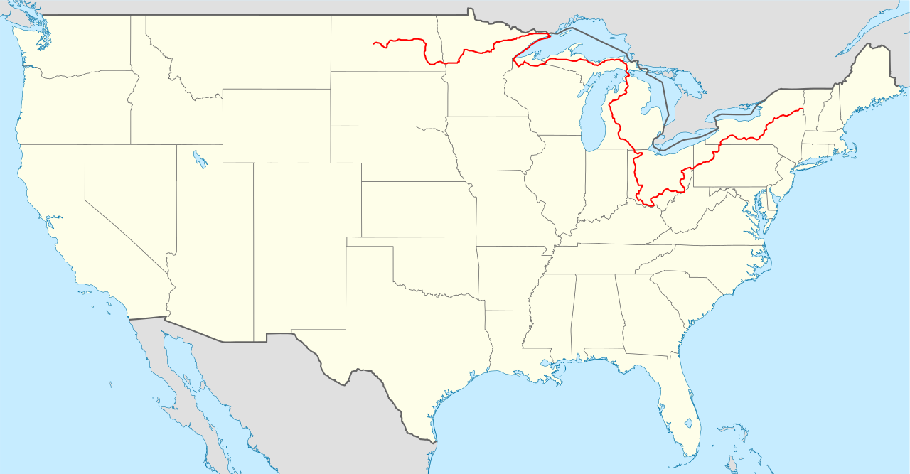
244:
239:
233:
97:
31:
21:
358:
683:
565:
357:
26:
1:
36:
678:North Country Trail by state
663:
620:Removed segment in Minnesota
383:Items portrayed in this file
7:
743:
10:
785:
732:Usage on zh.wikipedia.org
722:Usage on www.wikidata.org
712:Usage on it.wikipedia.org
702:Usage on fr.wikipedia.org
692:Usage on de.wikipedia.org
295:same or compatible license
132:
562:
331:File:USA_location_map.svg
16:
360:
340:1859x968 (738148 Bytes)
261:
104:This is a file from the
41:
649:
619:
598:20:01, 30 December 2023
173:
108:. Information from its
716:National Trails System
628:03:54, 9 February 2011
175:9 February 2011, 03:34
147:("lower 48") with the
111:description page there
336:2008-07-29T20:04:42Z
205:USA_location_map.svg
188:USA_location_map.svg
70:2,560 × 1,333 pixels
706:North Country Trail
696:North Country Trail
673:North Country Trail
656:North Country Trail
322:Original upload log
276:– to adapt the work
149:North Country Trail
143:Locator map of the
52:Other resolutions:
74:1,859 × 968 pixels
66:1,280 × 667 pixels
62:1,024 × 533 pixels
772:
771:
684:Global file usage
661:
457:copyright license
443:copyright license
369:
229:
228:
213:derivative work:
126:
125:
106:Wikimedia Commons
32:Global file usage
776:
754:
640:
610:
572:
413:copyright status
399:copyright status
367:
317:
314:
311:
308:
305:
297:as the original.
254:Creative Commons
248:
247:
243:
242:
237:
236:
221:
176:
139:
133:
122:
101:
100:
94:
88:
77:
58:640 × 333 pixels
54:320 × 167 pixels
48:800 × 417 pixels
784:
783:
779:
778:
777:
775:
774:
773:
742:
682:
669:
662:
646:
638:
616:
608:
564:
563:
560:
559:
558:
557:
556:
555:
554:
553:
551:
541:
540:
539:
537:
522:
521:
520:
519:
518:
517:
516:
515:
513:
512:9 February 2011
503:
502:
501:
499:
484:
483:
482:
481:
480:
479:
478:
477:
475:
463:
462:
461:
459:
440:
439:
438:
437:
436:
435:
434:
433:
431:
419:
418:
417:
415:
396:
395:
394:
393:
392:
390:
374:
373:
372:
324:
319:
318:
315:
312:
309:
306:
303:
302:
260:
249:
230:
219:
137:
128:
127:
116:
115:
114:is shown below.
90:
86:
79:
78:
51:
12:
11:
5:
782:
770:
769:
766:
762:
761:
758:
745:
741:
740:
739:
738:
730:
729:
728:
720:
719:
718:
710:
709:
708:
700:
699:
698:
685:
681:
680:
675:
665:
660:
659:
648:
644:
641:
635:
630:
625:
622:
621:
618:
614:
611:
605:
600:
595:
591:
590:
587:
584:
581:
578:
575:
567:
552:
549:
547:
546:
545:
543:
542:
538:
533:
531:
530:
529:
528:
526:
514:
511:
509:
508:
507:
505:
504:
500:
495:
493:
492:
491:
490:
488:
476:
471:
469:
468:
467:
465:
464:
460:
455:
453:
452:
451:
450:
448:
444:
432:
427:
425:
424:
423:
421:
420:
416:
411:
409:
408:
407:
406:
404:
400:
391:
386:
384:
381:
380:
379:
378:
366:
365:
362:
359:
350:Uploaded with
347:
346:
345:
344:
323:
320:
301:
300:
299:
298:
288:
279:
278:
277:
271:
264:You are free:
251:
250:
232:
227:
226:
225:
224:
211:
200:
196:
195:
194:
193:
190:
183:
179:
178:
172:
168:
167:
166:
165:
162:
159:
156:
140:
131:
124:
123:
102:
92:
91:
45:
40:
39:
34:
29:
24:
19:
9:
6:
4:
3:
2:
781:
767:
764:
763:
759:
756:
755:
752:
749:
737:
734:
733:
731:
727:
724:
723:
721:
717:
714:
713:
711:
707:
704:
703:
701:
697:
694:
693:
691:
690:
689:
679:
676:
674:
671:
670:
657:
653:
652:United States
647:
642:
636:
634:
631:
629:
626:
624:
623:
617:
612:
606:
604:
601:
599:
596:
593:
592:
588:
585:
582:
579:
576:
574:
573:
571:
550:image/svg+xml
548:
536:
532:
510:
498:
494:
474:
470:
458:
454:
430:
426:
414:
410:
389:
385:
382:
363:
356:
355:
354:
353:
343:
339:
335:
334:
332:
329:
328:
327:
307:CC BY-SA 3.0
296:
292:
289:
286:
283:
282:
280:
275:
272:
269:
266:
265:
263:
262:
258:
255:
238:
222:
216:
212:
210:
206:
203:
202:
201:
197:
191:
189:
186:
185:
184:
180:
169:
163:
160:
157:
154:
153:
152:
150:
146:
145:United States
141:
134:
120:
113:
112:
107:
103:
96:
95:
89:
84:
83:Original file
75:
71:
67:
63:
59:
55:
49:
44:
38:
35:
33:
30:
28:
25:
23:
20:
18:
15:
750:
747:
687:
637:1,859 × 968
607:1,859 × 968
569:
566:File history
352:derivativeFX
349:
348:
341:
338:NordNordWest
325:
290:
284:
273:
267:
209:NordNordWest
142:
119:You can help
109:
81:
22:File history
429:copyrighted
403:copyrighted
291:share alike
285:attribution
161:W: 125.5° W
136:Description
664:File usage
583:Dimensions
535:media type
525:media type
164:E: 66.5° W
158:S: 24.2° N
155:N: 49.8° N
27:File usage
768:968.38837
726:Q14716246
645:Bamyers99
615:Bamyers99
580:Thumbnail
577:Date/Time
497:inception
487:inception
215:Bamyers99
760:1858.625
744:Metadata
736:北部国家风景步道
639:(678 KB)
609:(691 KB)
364:Captions
274:to remix
268:to share
259:license.
37:Metadata
594:current
589:Comment
388:depicts
368:English
85:
765:Height
199:Author
182:Source
757:Width
177:(UTC)
586:User
316:true
313:true
220:talk
171:Date
17:File
207::
72:|
68:|
64:|
60:|
56:|
50:.
223:)
217:(
121:.
76:.
Text is available under the Creative Commons Attribution-ShareAlike License. Additional terms may apply.
