693:"}},"text\/plain":{"en":{"":"checksum"}}},"{\"value\":\"c3bd52ffaab7429d105c43f308bee01b5e5f37e3\",\"type\":\"string\"}":{"text\/html":{"en":{"P4092":"c3bd52ffaab7429d105c43f308bee01b5e5f37e3"}},"text\/plain":{"en":{"P4092":"c3bd52ffaab7429d105c43f308bee01b5e5f37e3"}}},"{\"value\":{\"entity-type\":\"property\",\"numeric-id\":459,\"id\":\"P459\"},\"type\":\"wikibase-entityid\"}":{"text\/html":{"en":{"":"
482:"}},"text\/plain":{"en":{"":"inception"}}},"{\"value\":{\"time\":\"+2010-11-30T00:00:00Z\",\"timezone\":0,\"before\":0,\"after\":0,\"precision\":11,\"calendarmodel\":\"http:\\\/\\\/www.wikidata.org\\\/entity\\\/Q1985727\"},\"type\":\"time\"}":{"text\/html":{"en":{"P571":"30 November 2010"}},"text\/plain":{"en":{"P571":"30 November 2010"}}}}": -->
38:
242:
689:
253:
94:
697:"}},"text\/plain":{"en":{"":"determination method"}}},"{\"value\":{\"entity-type\":\"item\",\"numeric-id\":13414952,\"id\":\"Q13414952\"},\"type\":\"wikibase-entityid\"}":{"text\/html":{"en":{"P459":"
655:"}},"text\/plain":{"en":{"":"media type"}}},"{\"value\":\"image\\\/jpeg\",\"type\":\"string\"}":{"text\/html":{"en":{"P1163":"image\/jpeg"}},"text\/plain":{"en":{"P1163":"image\/jpeg"}}}}": -->
438:"}},"text\/plain":{"en":{"":"copyright license"}}},"{\"value\":{\"entity-type\":\"item\",\"numeric-id\":14946043,\"id\":\"Q14946043\"},\"type\":\"wikibase-entityid\"}":{"text\/html":{"en":{"P275":"
394:"}},"text\/plain":{"en":{"":"copyright status"}}},"{\"value\":{\"entity-type\":\"item\",\"numeric-id\":50423863,\"id\":\"Q50423863\"},\"type\":\"wikibase-entityid\"}":{"text\/html":{"en":{"P6216":"
520:"}},"text\/plain":{"en":{"":"data size"}}},"{\"value\":{\"amount\":\"+270734\",\"unit\":\"http:\\\/\\\/www.wikidata.org\\\/entity\\\/Q8799\"},\"type\":\"quantity\"}":{"text\/html":{"en":{"P3575":"270,734
565:"}},"text\/plain":{"en":{"":"height"}}},"{\"value\":{\"amount\":\"+1728\",\"unit\":\"http:\\\/\\\/www.wikidata.org\\\/entity\\\/Q355198\"},\"type\":\"quantity\"}":{"text\/html":{"en":{"P2048":"1,728
610:"}},"text\/plain":{"en":{"":"width"}}},"{\"value\":{\"amount\":\"+1999\",\"unit\":\"http:\\\/\\\/www.wikidata.org\\\/entity\\\/Q355198\"},\"type\":\"quantity\"}":{"text\/html":{"en":{"P2049":"1,999
651:
300:– You must give appropriate credit, provide a link to the license, and indicate if changes were made. You may do so in any reasonable manner, but not in any way that suggests the licensor endorses you or your use.
819:, UK. Equirectangular map projection on WGS 84 datum, with N/S stretched 160% Geographic limits: *West: 3.15W *East: 2.78W *North: 51.67N *South: 51.47N |Source=[[w:Ordnance Survey|Ordnance S
956:
698:
439:
395:
991:
690:
652:
607:
562:
517:
391:
694:
479:
435:
1021:
60:
56:
52:
48:
42:
105:
73:
442:"}},"text\/plain":{"en":{"P275":"Creative Commons Attribution-ShareAlike 3.0 Unported"}}}}": -->
898:
231:
742:
465:
421:
893:
1011:
202:
307:
1006:
966:
708:
662:
621:
576:
531:
405:
735:
489:
449:
380:
263:
306:– If you remix, transform, or build upon the material, you must distribute your contributions under the
524:"}},"text\/plain":{"en":{"P3575":"270,734 byte"}}}}": -->
1081:
614:"}},"text\/plain":{"en":{"P2049":"1,999 pixel"}}}}": -->
569:"}},"text\/plain":{"en":{"P2048":"1,728 pixel"}}}}": -->
398:"}},"text\/plain":{"en":{"P6216":"copyrighted"}}}}": -->
829:
The following pages on the
English Knowledge use this file (pages on other projects are not listed):
797:
792:
64:
37:
340:
185:
113:
916:
1076:
873:
858:
701:"}},"text\/plain":{"en":{"P459":"SHA-1"}}}}": -->
971:
260:
1131:
8:
946:
1096:
1066:
888:
883:
206:
981:
100:
370:
1091:
1061:
838:
182:
926:
219:
1126:
1106:
1001:
843:
808:
863:
853:
848:
718:
672:
631:
586:
541:
499:
459:
415:
1051:
1031:
868:
833:
1046:
1036:
145:
Equirectangular map projection on WGS 84 datum, with N/S stretched 160%
878:
195:
Administrative borders and coastline data from
Boundary-Line product.
967:
Wikiproyecto:Ilustración/Taller de
Cartografía/Realizaciones/Europa
765:
Click on a date/time to view the file as it appeared at that time.
139:
271:
Contains
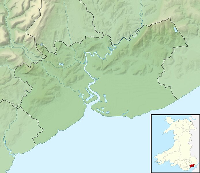
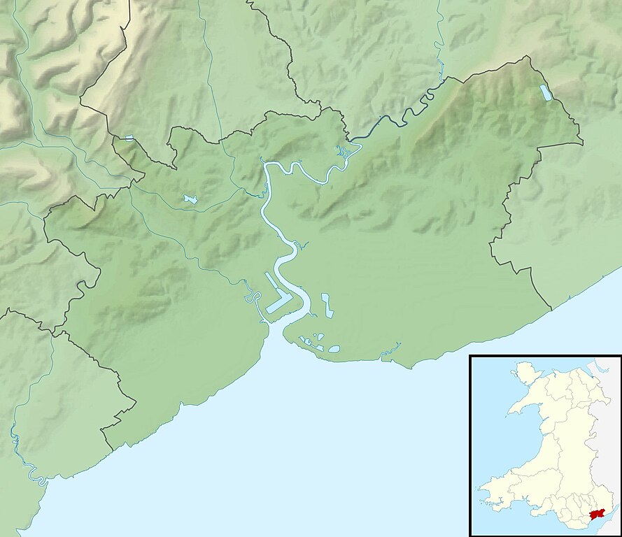
Ordnance Survey data © Crown copyright and database right
816:
936:
941:
171:
88:
364:
Add a one-line explanation of what this file represents
1116:
827:
78:(1,999 × 1,728 pixels, file size: 264 KB, MIME type:
907:
763:
466:
Creative
Commons Attribution-ShareAlike 3.0 Unported
440:
Creative
Commons Attribution-ShareAlike 3.0 Unported
112:
Commons is a freely licensed media file repository.
198:All other geographic data from Meridian 2 product.
1082:Modül:Konum haritası/veri/Galler Newport/belge
317:https://creativecommons.org/licenses/by-sa/3.0
93:
323:Creative Commons Attribution-Share Alike 3.0
241:
226:
167:
130:
947:Vorlage:Positionskarte Wales City of Newport
336:
215:
192:Relief data from Land-Form Panorama product.
177:
14:
611:
566:
521:
283:– to copy, distribute and transmit the work
1097:Module:Location map/data/Wales Newport/doc
1067:Module:Location map/data/Wales Newport/doc
899:Module:Location map/data/Wales Newport/doc
1012:モジュール:Location map/data/Wales Newport/doc
972:Plantilla:Mapa de localización de Newport
909:The following other wikis use this file:
815:{{Information |Description=Relief map of
1077:Modül:Konum haritası/veri/Galler Newport
724:c3bd52ffaab7429d105c43f308bee01b5e5f37e3
1092:Module:Location map/data/Wales Newport
1062:Module:Location map/data/Wales Newport
894:Module:Location map/data/Wales Newport
1007:モジュール:Location map/data/Wales Newport
203:File: United Kingdom location map.svg
124:
1022:ಟೆಂಪ್ಲೇಟು:Location map Wales Newport
957:Πρότυπο:Location map Ουαλία Νιούπορτ
927:Plantilya:Location map Wales Newport
264:Attribution-Share Alike 3.0 Unported
222:, created using Ordnance Survey data
1127:Template:Location map Wales Newport
1002:Template:Location map Wales Newport
756:
252:
247:
13:
1107:Batakan:Location map Wales Newport
369:
363:
238:
133:Newport UK relief location map.jpg
125:
71:
1145:
368:
828:
354:
294:Under the following conditions:
259:This file is licensed under the
251:
246:
240:
201:Inset derived from derived from
92:
31:
21:
917:قالب:Location map Wales Newport
351:
982:Modèle:Géolocalisation/Newport
904:
760:
350:
26:
1:
824:
376:Items portrayed in this file
7:
1103:Usage on war.wikipedia.org
923:Usage on ceb.wikipedia.org
10:
1150:
1123:Usage on zh.wikipedia.org
1113:Usage on www.wikidata.org
1088:Usage on uz.wikipedia.org
1073:Usage on tr.wikipedia.org
1058:Usage on si.wikipedia.org
1043:Usage on pl.wikibooks.org
1028:Usage on pl.wikipedia.org
1018:Usage on kn.wikipedia.org
998:Usage on ja.wikipedia.org
988:Usage on he.wikipedia.org
978:Usage on fr.wikipedia.org
963:Usage on es.wikipedia.org
953:Usage on el.wikipedia.org
933:Usage on de.wikipedia.org
913:Usage on ar.wikipedia.org
308:same or compatible license
127:
757:
16:
353:
274:
99:This is a file from the
36:
1052:Moduł:Mapa/dane/Newport
1032:Moduł:Mapa/dane/Newport
992:תבנית:מפת מיקום/ניופורט
814:
793:01:05, 30 November 2011
341:File:Newport UK map.svg
170:
103:. Information from its
1047:Moduł:Mapa/dane/GB-NWP
1037:Moduł:Mapa/dane/GB-NWP
874:Stelvio House, Newport
859:Monument to Sir Briggs
106:description page there
41:Size of this preview:
736:determination method
695:determination method
65:1,999 × 1,728 pixels
61:1,185 × 1,024 pixels
289:– to adapt the work
148:Geographic limits:
47:Other resolutions:
889:User:KJP1/sandbox2
884:Wales Seniors Open
905:Global file usage
822:
613:
568:
523:
450:copyright license
436:copyright license
362:
347:
346:
235:
232:Reusing this file
121:
120:
101:Wikimedia Commons
32:Global file usage
1141:
839:Castell Meredydd
805:
767:
745:
740:
640:
595:
550:
505:30 November 2010
406:copyright status
392:copyright status
360:
330:
327:
324:
321:
318:
310:as the original.
272:
261:Creative Commons
255:
254:
250:
249:
244:
243:
229:
173:
172:30 November 2010
134:
128:
117:
96:
95:
89:
83:
81:
68:
57:889 × 768 pixels
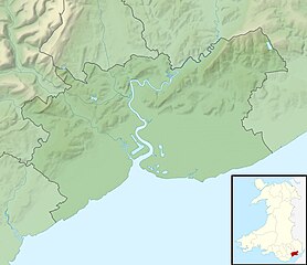
53:555 × 480 pixels
49:278 × 240 pixels
43:694 × 600 pixels
1149:
1148:
1144:
1143:
1142:
1140:
1139:
1138:
937:Caerleon Castle
903:
830:
823:
811:
803:
759:
758:
755:
754:
753:
752:
751:
750:
749:
748:
747:
746:
741:
738:
729:
728:
727:
725:
715:
714:
713:
711:
688:
687:
686:
685:
684:
683:
682:
681:
679:
669:
668:
667:
665:
650:
649:
648:
647:
646:
645:
644:
643:
641:
638:
628:
627:
626:
624:
605:
604:
603:
602:
601:
600:
599:
598:
596:
593:
583:
582:
581:
579:
560:
559:
558:
557:
556:
555:
554:
553:
551:
548:
538:
537:
536:
534:
515:
514:
513:
512:
511:
510:
509:
508:
506:
496:
495:
494:
492:
477:
476:
475:
474:
473:
472:
471:
470:
468:
456:
455:
454:
452:
433:
432:
431:
430:
429:
428:
427:
426:
424:
412:
411:
410:
408:
389:
388:
387:
386:
385:
383:
367:
366:
365:
348:
332:
331:
328:
325:
322:
319:
316:
315:
273:
270:
267:
256:
183:Ordnance Survey
132:
123:
122:
111:
110:
109:is shown below.
85:
79:
77:
70:
69:
46:
12:
11:
5:
1147:
1137:
1136:
1135:
1134:
1129:
1121:
1120:
1119:
1111:
1110:
1109:
1101:
1100:
1099:
1094:
1086:
1085:
1084:
1079:
1071:
1070:
1069:
1064:
1056:
1055:
1054:
1049:
1041:
1040:
1039:
1034:
1026:
1025:
1024:
1016:
1015:
1014:
1009:
1004:
996:
995:
994:
986:
985:
984:
976:
975:
974:
969:
961:
960:
959:
951:
950:
949:
944:
942:Newport Castle
939:
931:
930:
929:
921:
920:
919:
906:
902:
901:
896:
891:
886:
881:
876:
871:
866:
861:
856:
851:
846:
844:Celtic Classic
841:
836:
826:
821:
820:
813:
809:
806:
802:1,999 × 1,728
800:
795:
790:
786:
785:
782:
779:
776:
773:
770:
762:
734:
733:
732:
731:
730:
726:
723:
721:
720:
719:
717:
716:
712:
707:
705:
704:
703:
702:
700:
696:
692:
680:
677:
675:
674:
673:
671:
670:
666:
661:
659:
658:
657:
656:
654:
642:
636:
634:
633:
632:
630:
629:
625:
620:
618:
617:
616:
615:
609:
597:
591:
589:
588:
587:
585:
584:
580:
575:
573:
572:
571:
570:
564:
552:
546:
544:
543:
542:
540:
539:
535:
530:
528:
527:
526:
525:
519:
507:
504:
502:
501:
500:
498:
497:
493:
488:
486:
485:
484:
483:
481:
469:
464:
462:
461:
460:
458:
457:
453:
448:
446:
445:
444:
443:
441:
437:
425:
420:
418:
417:
416:
414:
413:
409:
404:
402:
401:
400:
399:
397:
393:
384:
379:
377:
374:
373:
372:
371:
359:
358:
355:
352:
345:
344:
338:
337:Other versions
334:
333:
314:
313:
312:
311:
301:
292:
291:
290:
284:
277:You are free:
268:
258:
257:
239:
236:
224:
223:
217:
213:
212:
211:
210:
199:
196:
193:
179:
175:
174:
169:
165:
164:
163:
162:
159:
156:
153:
138:Relief map of
135:
126:
119:
118:
97:
87:
86:
40:
35:
34:
29:
24:
19:
9:
6:
4:
3:
2:
1146:
1133:
1130:
1128:
1125:
1124:
1122:
1118:
1115:
1114:
1112:
1108:
1105:
1104:
1102:
1098:
1095:
1093:
1090:
1089:
1087:
1083:
1080:
1078:
1075:
1074:
1072:
1068:
1065:
1063:
1060:
1059:
1057:
1053:
1050:
1048:
1045:
1044:
1042:
1038:
1035:
1033:
1030:
1029:
1027:
1023:
1020:
1019:
1017:
1013:
1010:
1008:
1005:
1003:
1000:
999:
997:
993:
990:
989:
987:
983:
980:
979:
977:
973:
970:
968:
965:
964:
962:
958:
955:
954:
952:
948:
945:
943:
940:
938:
935:
934:
932:
928:
925:
924:
922:
918:
915:
914:
912:
911:
910:
900:
897:
895:
892:
890:
887:
885:
882:
880:
877:
875:
872:
870:
867:
865:
864:Penhow Castle
862:
860:
857:
855:
852:
850:
847:
845:
842:
840:
837:
835:
832:
831:
818:
812:
807:
801:
799:
796:
794:
791:
788:
787:
783:
780:
777:
774:
771:
769:
768:
766:
744:
737:
722:
710:
706:
676:
664:
660:
635:
623:
619:
590:
578:
574:
545:
533:
529:
503:
491:
487:
467:
463:
451:
447:
423:
419:
407:
403:
382:
378:
375:
356:
349:
342:
339:
335:
320:CC BY-SA 3.0
309:
305:
302:
299:
296:
295:
293:
288:
285:
282:
279:
278:
276:
275:
269:Attribution:
265:
262:
245:
237:
233:
228:
225:
221:
218:
214:
208:
204:
200:
197:
194:
191:
190:
189:
187:
184:
180:
176:
166:
161:South: 51.47N
160:
158:North: 51.67N
157:
154:
151:
150:
149:
146:
143:
141:
136:
129:
115:
108:
107:
102:
98:
91:
90:
84:
75:
74:Original file
66:
62:
58:
54:
50:
44:
39:
33:
30:
28:
25:
23:
20:
18:
15:
908:
854:Machen House
849:Kemeys Manor
764:
761:File history
303:
297:
286:
280:
207:NordNordWest
181:
147:
144:
137:
114:You can help
104:
72:
22:File history
869:Plas Machen
834:CAF Newport
422:copyrighted
396:copyrighted
343:- Blank map
304:share alike
298:attribution
155:East: 2.78W
152:West: 3.15W
131:Description
879:Wales Open
825:File usage
778:Dimensions
678:image/jpeg
663:media type
653:media type
227:Permission
80:image/jpeg
27:File usage
810:Nilfanion
775:Thumbnail
772:Date/Time
532:data size
518:data size
490:inception
480:inception
220:Nilfanion
1117:Q1772238
804:(264 KB)
709:checksum
691:checksum
547:270,734
357:Captions
287:to remix
281:to share
266:license.
186:OpenData
817:Newport
789:current
784:Comment
381:depicts
361:English
140:Newport
76:
637:1,999
592:1,728
577:height
563:height
216:Author
178:Source
142:, UK.
1132:末底斯城堡
743:SHA-1
699:SHA-1
639:pixel
622:width
612:pixel
608:width
594:pixel
567:pixel
781:User
549:byte
522:byte
329:true
326:true
168:Date
17:File
205:by
739::
188:.
63:|
59:|
55:|
51:|
45:.
234:)
230:(
209:.
116:.
82:)
67:.
