512:"}},"text\/plain":{"en":{"":"inception"}}},"{\"value\":{\"time\":\"+2012-12-15T00:00:00Z\",\"timezone\":0,\"before\":0,\"after\":0,\"precision\":11,\"calendarmodel\":\"http:\\\/\\\/www.wikidata.org\\\/entity\\\/Q1985727\"},\"type\":\"time\"}":{"text\/html":{"en":{"P571":"15 December 2012"}},"text\/plain":{"en":{"P571":"15 December 2012"}}}}": -->
38:
357:
260:
266:
271:
94:
1054:
550:"}},"text\/plain":{"en":{"":"media type"}}},"{\"value\":\"image\\\/jpeg\",\"type\":\"string\"}":{"text\/html":{"en":{"P1163":"image\/jpeg"}},"text\/plain":{"en":{"P1163":"image\/jpeg"}}}}": -->
468:"}},"text\/plain":{"en":{"":"copyright license"}}},"{\"value\":{\"entity-type\":\"item\",\"numeric-id\":14946043,\"id\":\"Q14946043\"},\"type\":\"wikibase-entityid\"}":{"text\/html":{"en":{"P275":"
424:"}},"text\/plain":{"en":{"":"copyright status"}}},"{\"value\":{\"entity-type\":\"item\",\"numeric-id\":50423863,\"id\":\"Q50423863\"},\"type\":\"wikibase-entityid\"}":{"text\/html":{"en":{"P6216":"
1049:
546:
508:
312:– You must give appropriate credit, provide a link to the license, and indicate if changes were made. You may do so in any reasonable manner, but not in any way that suggests the licensor endorses you or your use.
916:
1114:
911:
906:
469:
425:
959:
547:
421:
509:
465:
677:}} Quadratische Plattkarte, N-S-Streckung 105 %. Geographische Begrenzung der Karte: * N: 10.2° S * S: 27.4° S * W: 29.8° O * O: 41.8° O {{en|Location map of [[:...
766:
1263:
60:
56:
52:
48:
42:
105:
1004:
666:
73:
472:"}},"text\/plain":{"en":{"P275":"Creative Commons Attribution-ShareAlike 3.0 Unported"}}}}": -->
249:
643:
Adding
Tanzanian border claim (from https://www.nbs.go.tz/index.php/en/census-surveys/gis/385-2012-phc-shapefiles-level-one-and-two)
926:
495:
451:
726:
655:
650:
691:
319:
921:
557:
435:
954:
701:
519:
479:
410:
218:
1039:
356:
281:
1029:
974:
318:– If you remix, transform, or build upon the material, you must distribute your contributions under the
696:
969:
428:"}},"text\/plain":{"en":{"P6216":"copyrighted"}}}}": -->
687:
The following pages on the
English Knowledge use this file (pages on other projects are not listed):
625:
620:
64:
37:
1059:
741:
113:
1094:
861:
394:
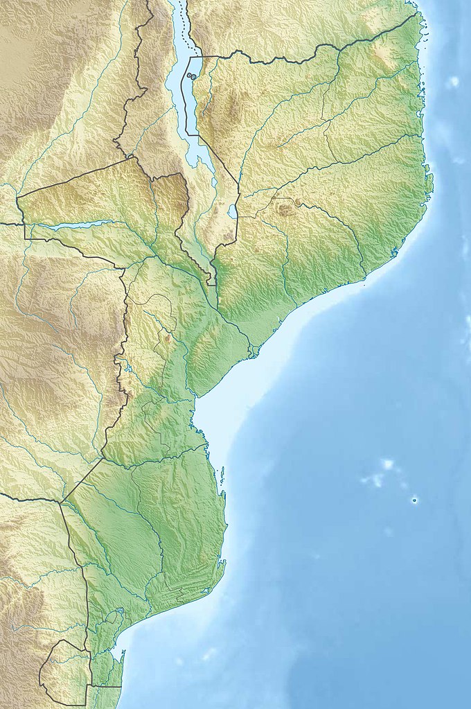
Physische
Positionskarte Mosambiks als Quadratische Plattkarte mit einer N-S-Streckung von 105%
1174:
901:
886:
746:
278:
8:
771:
984:
1089:
716:
222:
149:
Quadratische
Plattkarte, N-S-Streckung 105 %. Geographische Begrenzung der Karte:
896:
866:
851:
736:
177:
Equirectangular projection, N/S stretching 105 %. Geographic limits of the map:
100:
400:
846:
711:
1069:
1084:
1014:
1009:
881:
821:
816:
1124:
1104:
1219:
994:
636:
1254:
871:
856:
796:
751:
238:
1164:
1019:
841:
811:
791:
706:
567:
529:
489:
445:
172:
826:
806:
761:
756:
674:
144:
1249:
917:
User:Ty654/List of earthquakes from 2000-present exceeding magnitude 7+
836:
831:
786:
731:
1034:
1024:
891:
801:
776:
1144:
912:
User:Ty654/List of earthquakes from 1985-1989 exceeding magnitude 6+
907:
User:Ty654/List of earthquakes from 1950-1954 exceeding magnitude 6+
1139:
721:
593:
Click on a date/time to view the file as it appeared at that time.
1214:
1209:
1079:
876:
781:
673:{{Information |Description= {{de|Physische Positionskarte von
1229:
1204:
944:
1199:
1169:
1159:
200:
88:
1244:
1189:
1149:
1194:
767:
List of fossiliferous stratigraphic units in
Mozambique
386:
Add a one-line explanation of what this file represents
1224:
1179:
78:(1,329 × 2,000 pixels, file size: 1.23 MB, MIME type:
1154:
1134:
685:
1239:
935:
591:
496:
Creative
Commons Attribution-ShareAlike 3.0 Unported
470:
Creative
Commons Attribution-ShareAlike 3.0 Unported
112:
Commons is a freely licensed media file repository.
1184:
975:Módulu:Mapa de llocalización/datos/Mozambique/usu
1175:Knowledge:Kartenwerkstatt/Positionskarten/Afrika
329:https://creativecommons.org/licenses/by-sa/3.0
93:
970:Módulu:Mapa de llocalización/datos/Mozambique
335:Creative Commons Attribution-Share Alike 3.0
259:
244:
196:
130:
348:
234:
206:
14:
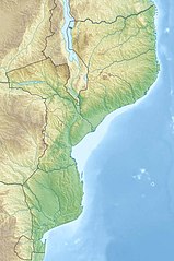
1055:মডিউল:অবস্থান মানচিত্র/উপাত্ত/মোজাম্বিক/নথি
295:– to copy, distribute and transmit the work
937:The following other wikis use this file:
1050:মডিউল:অবস্থান মানচিত্র/উপাত্ত/মোজাম্বিক
927:Module:Location map/data/Mozambique/doc
727:Chimanimani National Park (Mozambique)
124:
692:1986 Mozambican Tupolev Tu-134 crash
282:Attribution-Share Alike 3.0 Unported
1095:Mòdul:Location map/data/Moçambic/ús
922:Module:Location map/data/Mozambique
584:
270:
265:
13:
1125:Skabelon:Kortpositioner Mozambique
702:Bazaruto Archipelago National Park
399:
393:
385:
256:
165:
137:
133:Mozambique relief location map.jpg
125:
71:
1275:
1220:Liste von Kraftwerken in Mosambik
1105:Plantilya:Location map Mozambique
398:
1090:Mòdul:Location map/data/Moçambic
1070:Šablon:Lokacijska karta Mozambik
995:Taman Nasional Kapuloan Bazaruto
686:
376:
355:
306:Under the following conditions:
277:This file is licensed under the
269:
264:
258:
219:File:Mozambique location map.svg
92:
31:
21:
1255:Modul:Location map data mz/Doku
1165:Vorlage:Positionskarte Mosambik
1085:Plantilla:Location map Moçambic
373:
166:
932:
588:
372:
138:
26:
1:
362:Equivalent administrative map
143:Physische Positionskarte von
985:Şablon:Yer xəritəsi Mozambik
682:
406:Items portrayed in this file
7:
1236:Usage on de.wikivoyage.org
1115:Кеп:Меттиган карта Мозамбик
1101:Usage on ceb.wikipedia.org
991:Usage on ban.wikipedia.org
966:Usage on ast.wikipedia.org
228:STRM-30 data for the relief
10:
1280:
1250:Modul:Location map data mz
1131:Usage on de.wikipedia.org
1121:Usage on da.wikipedia.org
1111:Usage on ce.wikipedia.org
1076:Usage on ca.wikipedia.org
1066:Usage on bs.wikipedia.org
1046:Usage on bn.wikipedia.org
1001:Usage on bg.wikipedia.org
981:Usage on az.wikipedia.org
951:Usage on ar.wikipedia.org
941:Usage on af.wikipedia.org
697:2006 Mozambique earthquake
320:same or compatible license
127:
585:
211:
171:Physical location map of
16:
960:قالب:خريطة مواقع موزمبيق
375:
286:
99:This is a file from the
36:
742:Gorongosa National Park
672:
651:21:30, 15 December 2012
642:
199:
103:. Information from its
1140:Cahora-Bassa-Talsperre
862:Mount Yao (Mozambique)
106:description page there
41:Size of this preview:
902:User:Ishel99/sandbox
887:Nothophryne unilurio
747:Island of Mozambique
65:1,329 × 2,000 pixels
1215:Massingir-Talsperre
772:Magoe National Park
621:20:31, 3 March 2020
301:– to adapt the work
47:Other resolutions:
1210:Grande Hotel Beira
1145:Ilha de Moçambique
1080:Batalla de Ngomano
1005:Шаблон:ПК Мозамбик
717:Cheringoma Plateau
61:680 × 1,024 pixels
1264:more global usage
933:Global file usage
897:Proscelotes aenea
867:Mphanda Nkuwa Dam
737:Fernao Veloso Bay
680:
480:copyright license
466:copyright license
392:
384:
369:
368:
253:
250:Reusing this file
121:
120:
101:Wikimedia Commons
32:Global file usage
1271:
1230:Bucht von Tungue
847:Mount Morrumbala
712:Cahora Bassa Dam
663:
633:
595:
535:15 December 2012
436:copyright status
422:copyright status
390:
382:
359:
342:
339:
336:
333:
330:
322:as the original.
279:Creative Commons
273:
272:
268:
267:
262:
261:
247:
213:
202:
201:15 December 2012
170:
142:
134:
128:
117:
96:
95:
89:
83:
81:
68:
57:510 × 768 pixels
53:319 × 480 pixels
49:159 × 240 pixels
43:398 × 599 pixels
1279:
1278:
1274:
1273:
1272:
1270:
1269:
1268:
1205:Angoche (Insel)
931:
882:Njesi Highlands
822:Mount Gorongosa
817:Mount Chiperone
688:
681:
669:
661:
639:
631:
587:
586:
583:
582:
581:
580:
579:
578:
577:
576:
574:
564:
563:
562:
560:
545:
544:
543:
542:
541:
540:
539:
538:
536:
526:
525:
524:
522:
507:
506:
505:
504:
503:
502:
501:
500:
498:
486:
485:
484:
482:
463:
462:
461:
460:
459:
458:
457:
456:
454:
442:
441:
440:
438:
419:
418:
417:
416:
415:
413:
397:
396:
395:
388:
387:
370:
363:
360:
344:
343:
340:
337:
334:
331:
328:
327:
285:
274:
175:
147:
132:
123:
122:
111:
110:
109:is shown below.
85:
79:
77:
70:
69:
46:
12:
11:
5:
1277:
1266:of this file.
1260:
1259:
1258:
1257:
1252:
1247:
1242:
1234:
1233:
1232:
1227:
1222:
1217:
1212:
1207:
1202:
1197:
1192:
1187:
1182:
1177:
1172:
1167:
1162:
1157:
1152:
1147:
1142:
1137:
1129:
1128:
1127:
1119:
1118:
1117:
1109:
1108:
1107:
1099:
1098:
1097:
1092:
1087:
1082:
1074:
1073:
1072:
1064:
1063:
1062:
1057:
1052:
1044:
1043:
1042:
1040:Мапуто (залив)
1037:
1032:
1027:
1022:
1017:
1012:
1007:
999:
998:
997:
989:
988:
987:
979:
978:
977:
972:
964:
963:
962:
957:
955:سد كاهورا باسا
949:
948:
947:
945:Kaap Correntes
934:
930:
929:
924:
919:
914:
909:
904:
899:
894:
889:
884:
879:
874:
869:
864:
859:
854:
849:
844:
839:
834:
829:
824:
819:
814:
809:
804:
799:
794:
789:
784:
779:
774:
769:
764:
759:
754:
749:
744:
739:
734:
729:
724:
719:
714:
709:
704:
699:
694:
684:
679:
678:
671:
667:
664:
660:1,329 × 2,000
658:
653:
648:
645:
644:
641:
637:
634:
630:1,329 × 2,000
628:
623:
618:
614:
613:
610:
607:
604:
601:
598:
590:
575:
572:
570:
569:
568:
566:
565:
561:
556:
554:
553:
552:
551:
549:
537:
534:
532:
531:
530:
528:
527:
523:
518:
516:
515:
514:
513:
511:
499:
494:
492:
491:
490:
488:
487:
483:
478:
476:
475:
474:
473:
471:
467:
455:
450:
448:
447:
446:
444:
443:
439:
434:
432:
431:
430:
429:
427:
423:
414:
409:
407:
404:
403:
402:
401:
389:
381:
380:
377:
374:
367:
366:
365:
364:
361:
354:
350:
349:Other versions
346:
345:
326:
325:
324:
323:
313:
304:
303:
302:
296:
289:You are free:
276:
275:
257:
254:
242:
241:
236:
232:
231:
230:
229:
226:
208:
204:
203:
198:
194:
193:
192:
191:
188:
185:
182:
164:
163:
160:
157:
154:
135:
126:
119:
118:
97:
87:
86:
40:
35:
34:
29:
24:
19:
9:
6:
4:
3:
2:
1276:
1267:
1265:
1256:
1253:
1251:
1248:
1246:
1243:
1241:
1238:
1237:
1235:
1231:
1228:
1226:
1223:
1221:
1218:
1216:
1213:
1211:
1208:
1206:
1203:
1201:
1198:
1196:
1193:
1191:
1188:
1186:
1183:
1181:
1178:
1176:
1173:
1171:
1168:
1166:
1163:
1161:
1158:
1156:
1153:
1151:
1148:
1146:
1143:
1141:
1138:
1136:
1133:
1132:
1130:
1126:
1123:
1122:
1120:
1116:
1113:
1112:
1110:
1106:
1103:
1102:
1100:
1096:
1093:
1091:
1088:
1086:
1083:
1081:
1078:
1077:
1075:
1071:
1068:
1067:
1065:
1061:
1058:
1056:
1053:
1051:
1048:
1047:
1045:
1041:
1038:
1036:
1033:
1031:
1028:
1026:
1023:
1021:
1018:
1016:
1013:
1011:
1008:
1006:
1003:
1002:
1000:
996:
993:
992:
990:
986:
983:
982:
980:
976:
973:
971:
968:
967:
965:
961:
958:
956:
953:
952:
950:
946:
943:
942:
940:
939:
938:
928:
925:
923:
920:
918:
915:
913:
910:
908:
905:
903:
900:
898:
895:
893:
890:
888:
885:
883:
880:
878:
875:
873:
872:Mueda Plateau
870:
868:
865:
863:
860:
858:
857:Mount Tumbine
855:
853:
850:
848:
845:
843:
840:
838:
835:
833:
830:
828:
825:
823:
820:
818:
815:
813:
810:
808:
805:
803:
800:
798:
797:Massingir Dam
795:
793:
790:
788:
785:
783:
780:
778:
775:
773:
770:
768:
765:
763:
760:
758:
755:
753:
752:Lake Amaramba
750:
748:
745:
743:
740:
738:
735:
733:
730:
728:
725:
723:
720:
718:
715:
713:
710:
708:
705:
703:
700:
698:
695:
693:
690:
689:
676:
670:
665:
659:
657:
654:
652:
649:
647:
646:
640:
635:
629:
627:
624:
622:
619:
616:
615:
611:
608:
605:
602:
599:
597:
596:
594:
571:
559:
555:
533:
521:
517:
497:
493:
481:
477:
453:
449:
437:
433:
412:
408:
405:
378:
371:
358:
353:
352:
351:
347:
332:CC BY-SA 3.0
321:
317:
314:
311:
308:
307:
305:
300:
297:
294:
291:
290:
288:
287:
283:
280:
263:
255:
251:
246:
243:
240:
237:
233:
227:
224:
220:
217:
216:
215:
209:
205:
195:
189:
186:
183:
180:
179:
178:
174:
169:
161:
158:
155:
152:
151:
150:
146:
141:
136:
129:
115:
108:
107:
102:
98:
91:
90:
84:
75:
74:Original file
66:
62:
58:
54:
50:
44:
39:
33:
30:
28:
25:
23:
20:
18:
15:
1261:
1200:Amaramba-See
1170:Monte Namuli
1160:Maputo-Bucht
936:
852:Mount Ribáuè
842:Mount Mecula
812:Monte Muambe
792:Maputo River
707:Cahora Bassa
592:
589:File history
315:
309:
298:
292:
223:NordNordWest
210:
176:
167:
148:
139:
114:You can help
104:
72:
22:File history
1190:Ibo (Insel)
1150:Monte Binga
1030:Кахора Баса
827:Mount Inago
807:Monte Binga
762:Lake Shirwa
757:Lake Chiuta
452:copyrighted
426:copyrighted
316:share alike
310:attribution
131:Description
1245:Vilanculos
1195:Monte Mabu
837:Mount Mabu
832:Mount Lico
787:Maputo Bay
732:Chocas Mar
683:File usage
606:Dimensions
573:image/jpeg
558:media type
548:media type
245:Permission
190:E: 41.8° E
187:W: 29.8° E
184:S: 27.4° S
181:N: 10.2° S
173:Mozambique
162:O: 41.8° O
159:W: 29.8° O
156:S: 27.4° S
153:N: 10.2° S
80:image/jpeg
27:File usage
1225:Benguerra
1180:Quirimbas
892:Pemba Bay
802:Memba Bay
777:Manyikeni
662:(1.11 MB)
632:(1.23 MB)
603:Thumbnail
600:Date/Time
520:inception
510:inception
168:English:
140:Deutsch:
1155:Bazaruto
1135:Mosambik
722:Chibuene
675:Mosambik
379:Captions
299:to remix
293:to share
284:license.
214:, using
212:Own work
145:Mosambik
668:Carport
617:current
612:Comment
411:depicts
383:English
239:Carport
76:
1240:Maputo
1185:Inhaca
1060:মাপুতো
1015:Матола
1010:Мапуто
877:Ngalue
782:Maputo
638:Sémhur
391:German
235:Author
207:Source
1262:View
1020:Бейра
1035:Саве
1025:Шире
609:User
341:true
338:true
197:Date
17:File
221:by
63:|
59:|
55:|
51:|
45:.
252:)
248:(
225:.
116:.
82:)
67:.

