38:
249:
206:
296:
100:
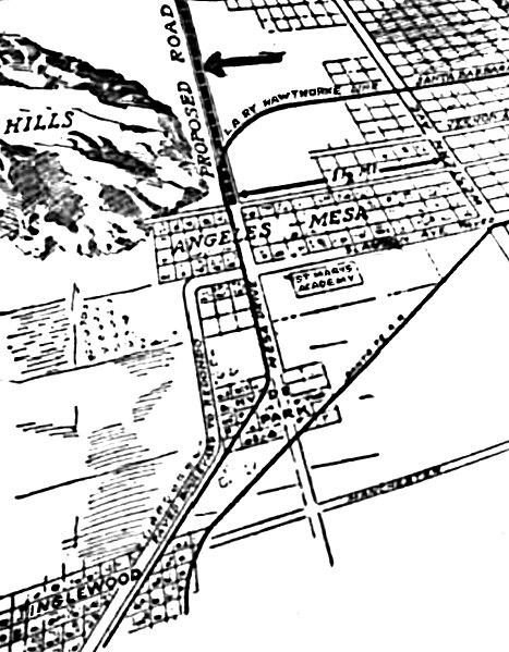
North is at the top of this map from the ‘’Los
Angeles Times,’’ August 20, 1916. Angeles Mesa lies horizontally near the center, bounded on the west by Baldwin Hills and on the east by Western Avenue. St. Mary’s Academy is south of it across
110:
56:
52:
48:
42:
69:
433:
178:
408:
121:. Southwest from Mesa Drive lies a paved boulevard (now Florence Avenue) to Redondo Beach. Manchester Avenue (now Boulevard) is at the bottom.
113:, running on Santa Barbara Avenue (now Martin Luther King Drive) curving into Mesa Drive, continuing to Inglewood, at bottom left. A
318:
364:
This file contains additional information, probably added from the digital camera or scanner used to create or digitize it.
295:
290:
60:
37:
222:
367:
If the file has been modified from its original state, some details may not fully reflect the modified file.
327:
144:
314:
348:
344:
The following pages on the
English Knowledge use this file (pages on other projects are not listed):
218:
353:
118:
306:
8:
106:
114:
109:. The curved horizontal line on the upper right (now Leimert Avenue) marks the
102:
427:
232:
213:
248:
105:. The “Proposed Road” (signaled by an arrow) and Mesa Drive are now part of
145:
https://www.newspapers.com/image/380514763/?terms=%22Angeles%2BMesa%22
263:
Click on a date/time to view the file as it appeared at that time.
342:
74:(1,152 × 1,478 pixels, file size: 647 KB, MIME type:
261:
434:Images in the public domain in the United States
425:
335:
151:
95:
161:
126:
14:
326:Uploading an old public-domain work using
82:
117:track runs northeast-southwest through
426:
217:in the United States because it was
200:
13:
362:
111:Los Angeles Railway Hawthorne line
83:
67:
445:
369:
343:
247:
204:
21:
336:You cannot overwrite this file.
258:
26:
1:
168:(Life time: Not applicable.)
31:
339:
196:
7:
359:
10:
450:
225:) before January 1, 1929.
85:
415:File change date and time
349:Angeles Mesa, Los Angeles
173:
16:
221:(or registered with the
36:
325:
354:Hyde Park, Los Angeles
41:Size of this preview:
389:Horizontal resolution
223:U.S. Copyright Office
418:14:04, 26 April 2020
291:21:39, 26 April 2020
235:in the United States
211:This work is in the
132:Original publication
61:1,152 × 1,478 pixels
397:Vertical resolution
92:
47:Other resolutions:
328:File Upload Wizard
136:Los Angeles Times,
107:Crenshaw Boulevard
90:
422:
421:
332:
255:
254:
194:
193:
182:
179:Reusing this file
166:Los Angeles Times
115:Santa Fe Railroad
91:File information
441:
370:
323:
322:
308:BeenAroundAWhile
303:
265:
251:
242:
239:
236:
230:
208:
207:
201:
176:
156:August 20, 1916
141:Immediate source
93:
89:
79:
77:
64:
57:598 × 768 pixels
53:374 × 480 pixels
49:187 × 240 pixels
43:467 × 599 pixels
449:
448:
444:
443:
442:
440:
439:
438:
424:
423:
358:
345:
338:
333:
312:
311:
309:
301:
257:
256:
244:
240:
237:
231:
228:
205:
199:
189:
175:
167:
139:
138:August 20, 1916
88:
81:
75:
73:
66:
65:
46:
12:
11:
5:
447:
437:
436:
420:
419:
416:
412:
411:
409:Pixelmator 3.9
406:
402:
401:
398:
394:
393:
390:
386:
385:
382:
378:
377:
374:
361:
357:
356:
351:
341:
334:
331:
330:
324:
307:
304:
300:1,152 × 1,478
298:
293:
288:
284:
283:
280:
277:
274:
271:
268:
260:
253:
252:
245:
226:
209:
198:
195:
192:
191:
183:
171:
170:
163:
159:
158:
153:
149:
148:
128:
124:
123:
103:Slauson Avenue
97:
87:
84:
40:
35:
34:
29:
24:
19:
9:
6:
4:
3:
2:
446:
435:
432:
431:
429:
417:
414:
413:
410:
407:
405:Software used
404:
403:
399:
396:
395:
391:
388:
387:
383:
380:
379:
375:
373:User comments
372:
371:
368:
365:
355:
352:
350:
347:
346:
337:
329:
320:
316:
310:
305:
299:
297:
294:
292:
289:
286:
285:
281:
278:
275:
272:
269:
267:
266:
264:
250:
246:
243:
234:
233:Public domain
229:Public domain
224:
220:
216:
215:
214:public domain
210:
203:
202:
190:
187:
184:
180:
172:
169:
164:
160:
157:
154:
150:
147:
146:
142:
137:
133:
129:
125:
122:
120:
116:
112:
108:
104:
98:
94:
80:
71:
70:Original file
62:
58:
54:
50:
44:
39:
33:
30:
28:
25:
23:
20:
18:
15:
366:
363:
262:
259:File history
227:
212:
188:
185:
165:
155:
140:
135:
131:
130:
99:
96:Description
68:
22:File history
381:Orientation
186:See below.
376:Screenshot
340:File usage
276:Dimensions
174:Permission
76:image/jpeg
27:File usage
273:Thumbnail
270:Date/Time
219:published
197:Licensing
119:Hyde Park
428:Category
360:Metadata
319:contribs
302:(647 KB)
32:Metadata
400:144 dpi
392:144 dpi
287:current
282:Comment
162:Author
127:Source
86:Summary
72:
384:Normal
241:false
238:false
152:Date
315:talk
279:User
17:File
430::
317:|
143::
134::
59:|
55:|
51:|
45:.
321:)
313:(
181:)
177:(
78:)
63:.
Text is available under the Creative Commons Attribution-ShareAlike License. Additional terms may apply.

