703:"}},"text\/plain":{"en":{"":"coordinates of the point of view"}}},"{\"value\":{\"latitude\":51.297079,\"longitude\":-2.884894,\"altitude\":null,\"precision\":1.0e-6,\"globe\":\"http:\\\/\\\/www.wikidata.org\\\/entity\\\/Q2\"},\"type\":\"globecoordinate\"}":{"text\/html":{"en":{"P1259":"51\u00b017'49.484"N, 2\u00b053'5.618"W"}},"text\/plain":{"en":{"P1259":"51\u00b017'49.484\"N, 2\u00b053'5.618\"W"}}}}": -->
401:"}},"text\/plain":{"en":{"":"author name string"}}},"{\"value\":\"John Thorn\",\"type\":\"string\"}":{"text\/html":{"en":{"P2093":"John Thorn"}},"text\/plain":{"en":{"P2093":"John Thorn"}}},"{\"value\":{\"entity-type\":\"property\",\"numeric-id\":3831,\"id\":\"P3831\"},\"type\":\"wikibase-entityid\"}":{"text\/html":{"en":{"":"
741:"}},"text\/plain":{"en":{"":"inception"}}},"{\"value\":{\"time\":\"+1964-05-01T00:00:00Z\",\"timezone\":0,\"before\":0,\"after\":0,\"precision\":10,\"calendarmodel\":\"http:\\\/\\\/www.wikidata.org\\\/entity\\\/Q1985727\"},\"type\":\"time\"}":{"text\/html":{"en":{"P571":"May 1964"}},"text\/plain":{"en":{"P571":"May 1964"}}}}": -->
580:
385:
200:
221:
259:
264:
72:
397:"}},"text\/plain":{"en":{"P2699":"https:\/\/www.geograph.org.uk\/profile\/3253"}}},"{\"value\":{\"entity-type\":\"property\",\"numeric-id\":2093,\"id\":\"P2093\"},\"type\":\"wikibase-entityid\"}":{"text\/html":{"en":{"":"
588:"}},"text\/plain":{"en":{"P7482":"file available on the internet"}}},"{\"value\":{\"entity-type\":\"property\",\"numeric-id\":137,\"id\":\"P137\"},\"type\":\"wikibase-entityid\"}":{"text\/html":{"en":{"":"
596:"}},"text\/plain":{"en":{"P137":"Geograph Britain and Ireland"}}},"{\"value\":{\"entity-type\":\"property\",\"numeric-id\":7384,\"id\":\"P7384\"},\"type\":\"wikibase-entityid\"}":{"text\/html":{"en":{"":"
405:"}},"text\/plain":{"en":{"":"object of statement has role"}}},"{\"value\":{\"entity-type\":\"item\",\"numeric-id\":33231,\"id\":\"Q33231\"},\"type\":\"wikibase-entityid\"}":{"text\/html":{"en":{"P3831":"
540:"}},"text\/plain":{"en":{"":"copyright license"}}},"{\"value\":{\"entity-type\":\"item\",\"numeric-id\":19068220,\"id\":\"Q19068220\"},\"type\":\"wikibase-entityid\"}":{"text\/html":{"en":{"P275":"
496:"}},"text\/plain":{"en":{"":"copyright status"}}},"{\"value\":{\"entity-type\":\"item\",\"numeric-id\":50423863,\"id\":\"Q50423863\"},\"type\":\"wikibase-entityid\"}":{"text\/html":{"en":{"P6216":"
584:"}},"text\/plain":{"en":{"":"source of file"}}},"{\"value\":{\"entity-type\":\"item\",\"numeric-id\":74228490,\"id\":\"Q74228490\"},\"type\":\"wikibase-entityid\"}":{"text\/html":{"en":{"P7482":"
592:"}},"text\/plain":{"en":{"":"operator"}}},"{\"value\":{\"entity-type\":\"item\",\"numeric-id\":1503119,\"id\":\"Q1503119\"},\"type\":\"wikibase-entityid\"}":{"text\/html":{"en":{"P137":"
604:"}},"text\/plain":{"en":{"P7384":"73684"}}},"{\"value\":{\"entity-type\":\"property\",\"numeric-id\":973,\"id\":\"P973\"},\"type\":\"wikibase-entityid\"}":{"text\/html":{"en":{"":"
389:"}},"text\/plain":{"en":{"":"creator"}}},"{\"value\":{\"entity-type\":\"property\",\"numeric-id\":2699,\"id\":\"P2699\"},\"type\":\"wikibase-entityid\"}":{"text\/html":{"en":{"":"
699:
600:"}},"text\/plain":{"en":{"":"geograph.org.uk image ID"}}},"{\"value\":\"73684\",\"type\":\"string\"}":{"text\/html":{"en":{"P7384":"
311:– You must give appropriate credit, provide a link to the license, and indicate if changes were made. You may do so in any reasonable manner, but not in any way that suggests the licensor endorses you or your use.
183:
43:
585:
541:
497:
601:
593:
406:
700:
597:
581:
493:
402:
398:
390:
177:
738:
605:
589:
537:
394:
386:
609:
834:{{Information |Description=Loxton from Crook Peak |Source=From |Date=1964-05 |Author= |Permission=Creative Commons Attribution Share-alike license
544:"}},"text\/plain":{"en":{"P275":"Creative Commons Attribution-ShareAlike 2.0 Generic"}}}}": -->
155:
612:"}},"text\/plain":{"en":{"P973":"https:\/\/www.geograph.org.uk\/photo\/73684"}}}}": -->
635:
567:
523:
193:
896:
655:
228:
964:
This file contains additional information, probably added from the digital camera or scanner used to create or digitize it.
318:
478:
710:
663:
619:
507:
471:
458:
443:
848:
748:
678:
648:
551:
416:
375:
274:
967:
If the file has been modified from its original state, some details may not fully reflect the modified file.
1000:
317:– If you remix, transform, or build upon the material, you must distribute your contributions under the
235:
on the
Geograph website for the photographer's contact details. The copyright on this image is owned by
409:"}},"text\/plain":{"en":{"P3831":"photographer"}}}}": -->
500:"}},"text\/plain":{"en":{"P6216":"copyrighted"}}}}": -->
844:
The following pages on the
English Knowledge use this file (pages on other projects are not listed):
91:
83:
51:
450:
271:
685:
670:
8:
215:
199:
931:
240:
78:
365:
853:
858:
816:
811:
42:
144:
134:
1015:
758:
720:
629:
561:
517:
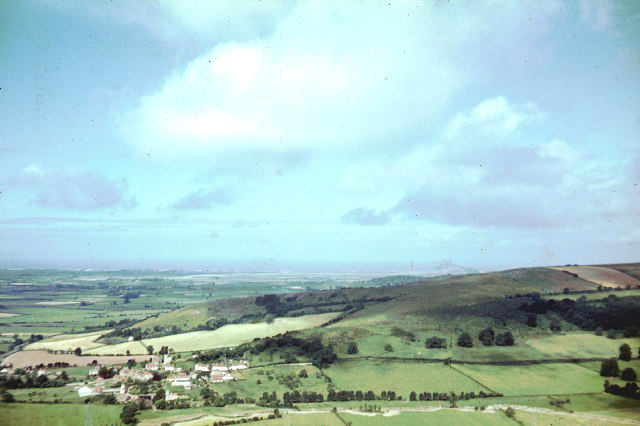
426:
220:
951:
827:
232:
784:
Click on a date/time to view the file as it appeared at that time.
185:
876:
178:
51° 17′ 49.48″ N, 2° 53′ 05.62″ W
906:
886:
926:
66:
359:
Add a one-line explanation of what this file represents
123:
941:
842:
867:
782:
162:
Creative
Commons Attribution Share-alike license 2.0
90:
Commons is a freely licensed media file repository.
916:
568:
Creative
Commons Attribution-ShareAlike 2.0 Generic
542:
Creative
Commons Attribution-ShareAlike 2.0 Generic
56:(640 × 426 pixels, file size: 77 KB, MIME type:
328:https://creativecommons.org/licenses/by-sa/2.0
71:
334:Creative Commons Attribution-Share Alike 2.0
252:
150:
119:
108:
932:Somerset'teki civil parishlerin listesi
395:https:\/\/www.geograph.org.uk\/profile\/3253
140:
129:
14:
610:https:\/\/www.geograph.org.uk\/photo\/73684
294:– to copy, distribute and transmit the work
869:The following other wikis use this file:
451:https://www.geograph.org.uk/profile/3253
686:https://www.geograph.org.uk/photo/73684
192:View this and other nearby images on:
102:
239:and is licensed for reuse under the
168:
775:
275:Attribution-Share Alike 2.0 Generic
263:
258:
243:Attribution-ShareAlike 2.0 license.
13:
962:
948:Usage on zh-min-nan.wikipedia.org
849:List of civil parishes in Somerset
364:
358:
249:
226:
103:
49:
1032:
969:
363:
843:
711:coordinates of the point of view
701:coordinates of the point of view
349:
305:Under the following conditions:
270:This file is licensed under the
262:
257:
251:
219:
198:
184:
70:
31:
21:
346:
46:No higher resolution available.
864:
779:
636:file available on the internet
586:file available on the internet
345:
227:This image was taken from the
26:
1:
36:
1001:Adobe Photoshop Elements 2.0
839:
726:51°17'49.484"N, 2°53'5.618"W
656:Geograph Britain and Ireland
594:Geograph Britain and Ireland
472:object of statement has role
403:object of statement has role
371:Items portrayed in this file
211:
7:
959:
873:Usage on ceb.wikipedia.org
10:
1037:
938:Usage on www.wikidata.org
923:Usage on tr.wikipedia.org
913:Usage on pl.wikipedia.org
903:Usage on nl.wikipedia.org
893:Usage on ja.wikipedia.org
883:Usage on fr.wikipedia.org
319:same or compatible license
105:
1007:File change date and time
776:
16:
664:geograph.org.uk image ID
598:geograph.org.uk image ID
348:
285:
77:This is a file from the
41:
1010:16:26, 10 February 2004
833:
122:
81:. Information from its
812:17:43, 16 October 2009
233:this photograph's page
204:51.297079; -2.884894
115:Loxton from Crook Peak
84:description page there
981:Horizontal resolution
989:Vertical resolution
300:– to adapt the work
459:author name string
399:author name string
1024:
1023:
952:Loxton (Somerset)
907:Loxton (Engeland)
887:Loxton (Somerset)
877:Loxton (distrito)
865:Global file usage
837:
552:copyright license
538:copyright license
357:
248:
247:
231:collection. See
209:
208:
166:
165:
159:
156:Reusing this file
99:
98:
79:Wikimedia Commons
32:Global file usage
1028:
970:
927:Loxton, Somerset
854:Loxton, Somerset
824:
786:
688:
683:
679:described at URL
673:
668:
658:
653:
606:described at URL
508:copyright status
494:copyright status
481:
476:
466:
463:
453:
448:
355:
341:
338:
335:
332:
329:
321:as the original.
283:
272:Creative Commons
266:
265:
261:
260:
255:
254:
241:Creative Commons
229:Geograph project
223:
216:
205:
202:
188:
187:
181:
180:
169:
153:
125:
112:
106:
95:
74:
73:
67:
61:
59:
1036:
1035:
1031:
1030:
1029:
1027:
1026:
1025:
958:
863:
845:
838:
830:
822:
778:
777:
774:
773:
772:
771:
770:
769:
768:
767:
765:
755:
754:
753:
751:
736:
735:
734:
733:
732:
731:
730:
729:
727:
717:
716:
715:
713:
698:
697:
696:
695:
694:
693:
692:
691:
690:
689:
684:
681:
675:
674:
669:
666:
660:
659:
654:
651:
642:
641:
640:
638:
626:
625:
624:
622:
579:
578:
577:
576:
575:
574:
573:
572:
570:
558:
557:
556:
554:
535:
534:
533:
532:
531:
530:
529:
528:
526:
514:
513:
512:
510:
491:
490:
489:
488:
487:
486:
485:
484:
483:
482:
477:
474:
468:
467:
464:
461:
455:
454:
449:
446:
437:
436:
435:
433:
423:
422:
421:
419:
384:
383:
382:
381:
380:
378:
362:
361:
360:
343:
342:
339:
336:
333:
330:
327:
326:
284:
281:
278:
267:
244:
214:
203:
176:
175:
172:Camera location
167:
135:geograph.org.uk
110:
101:
100:
89:
88:
87:is shown below.
63:
57:
55:
48:
47:
12:
11:
5:
1034:
1022:
1021:
1018:
1012:
1011:
1008:
1004:
1003:
998:
994:
993:
990:
986:
985:
982:
978:
977:
974:
961:
957:
956:
955:
954:
946:
945:
944:
936:
935:
934:
929:
921:
920:
919:
911:
910:
909:
901:
900:
899:
891:
890:
889:
881:
880:
879:
866:
862:
861:
859:North Somerset
856:
851:
841:
836:
835:
832:
828:
825:
819:
814:
809:
805:
804:
801:
798:
795:
792:
789:
781:
766:
763:
761:
760:
759:
757:
756:
752:
747:
745:
744:
743:
742:
740:
728:
725:
723:
722:
721:
719:
718:
714:
709:
707:
706:
705:
704:
702:
677:
676:
662:
661:
647:
646:
645:
644:
643:
639:
634:
632:
631:
630:
628:
627:
623:
620:source of file
618:
616:
615:
614:
613:
611:
607:
603:
599:
595:
591:
587:
583:
582:source of file
571:
566:
564:
563:
562:
560:
559:
555:
550:
548:
547:
546:
545:
543:
539:
527:
522:
520:
519:
518:
516:
515:
511:
506:
504:
503:
502:
501:
499:
495:
470:
469:
457:
456:
442:
441:
440:
439:
438:
434:
431:
429:
428:
427:
425:
424:
420:
415:
413:
412:
411:
410:
408:
404:
400:
396:
392:
388:
379:
374:
372:
369:
368:
367:
366:
354:
353:
350:
347:
325:
324:
323:
322:
312:
303:
302:
301:
295:
288:You are free:
279:
269:
268:
250:
246:
245:
224:
213:
210:
207:
206:
196:
190:
173:
164:
163:
160:
148:
147:
142:
138:
137:
131:
127:
126:
121:
117:
116:
113:
104:
97:
96:
75:
65:
64:
45:
40:
39:
34:
29:
24:
19:
9:
6:
4:
3:
2:
1033:
1019:
1017:
1014:
1013:
1009:
1006:
1005:
1002:
999:
997:Software used
996:
995:
991:
988:
987:
983:
980:
979:
975:
972:
971:
968:
965:
953:
950:
949:
947:
943:
940:
939:
937:
933:
930:
928:
925:
924:
922:
918:
915:
914:
912:
908:
905:
904:
902:
898:
895:
894:
892:
888:
885:
884:
882:
878:
875:
874:
872:
871:
870:
860:
857:
855:
852:
850:
847:
846:
831:
826:
820:
818:
815:
813:
810:
807:
806:
802:
799:
796:
793:
790:
788:
787:
785:
762:
750:
746:
724:
712:
708:
687:
680:
672:
665:
657:
650:
637:
633:
621:
617:
569:
565:
553:
549:
525:
521:
509:
505:
480:
473:
460:
452:
445:
430:
418:
414:
377:
373:
370:
351:
344:
331:CC BY-SA 2.0
320:
316:
313:
310:
307:
306:
304:
299:
296:
293:
290:
289:
287:
286:
280:Attribution:
276:
273:
256:
242:
238:
234:
230:
225:
222:
218:
217:
201:
197:
195:
194:OpenStreetMap
191:
189:
179:
174:
171:
170:
161:
157:
152:
149:
146:
143:
139:
136:
132:
128:
118:
114:
107:
93:
86:
85:
80:
76:
69:
68:
62:
53:
44:
38:
35:
33:
30:
28:
25:
23:
20:
18:
15:
1020:Uncalibrated
966:
963:
868:
783:
780:File history
479:photographer
407:photographer
314:
308:
297:
291:
236:
92:You can help
82:
50:
22:File history
1016:Color space
973:Orientation
524:copyrighted
498:copyrighted
315:share alike
309:attribution
109:Description
840:File usage
821:640 × 426
797:Dimensions
465:John Thorn
432:some value
282:John Thorn
237:John Thorn
151:Permission
145:John Thorn
111:Loxton.jpg
58:image/jpeg
52:Loxton.jpg
27:File usage
992:1,800 dpi
984:1,800 dpi
897:ノース・サマセット
794:Thumbnail
791:Date/Time
749:inception
739:inception
212:Licensing
960:Metadata
942:Q6694402
764:May 1964
649:operator
590:operator
352:Captions
298:to remix
292:to share
277:license.
124:May 1964
37:Metadata
823:(77 KB)
808:current
803:Comment
417:creator
387:creator
376:depicts
356:English
54:
976:Normal
917:Loxton
182:
141:Author
130:Source
671:73684
602:73684
133:From
829:Rodw
800:User
340:true
337:true
120:Date
17:File
444:URL
391:URL
682::
667::
652::
475::
462::
447::
158:)
154:(
94:.
60:)
