43:
527:"}},"text\/plain":{"en":{"":"inception"}}},"{\"value\":{\"time\":\"+2015-11-26T00:00:00Z\",\"timezone\":0,\"before\":0,\"after\":0,\"precision\":11,\"calendarmodel\":\"http:\\\/\\\/www.wikidata.org\\\/entity\\\/Q1985727\"},\"type\":\"time\"}":{"text\/html":{"en":{"P571":"26 November 2015"}},"text\/plain":{"en":{"P571":"26 November 2015"}}}}": -->
200:
303:
257:
309:
314:
95:
565:"}},"text\/plain":{"en":{"":"media type"}}},"{\"value\":\"image\\\/svg+xml\",\"type\":\"string\"}":{"text\/html":{"en":{"P1163":"image\/svg+xml"}},"text\/plain":{"en":{"P1163":"image\/svg+xml"}}}}": -->
483:"}},"text\/plain":{"en":{"":"copyright license"}}},"{\"value\":{\"entity-type\":\"item\",\"numeric-id\":18199165,\"id\":\"Q18199165\"},\"type\":\"wikibase-entityid\"}":{"text\/html":{"en":{"P275":"
439:"}},"text\/plain":{"en":{"":"copyright status"}}},"{\"value\":{\"entity-type\":\"item\",\"numeric-id\":50423863,\"id\":\"Q50423863\"},\"type\":\"wikibase-entityid\"}":{"text\/html":{"en":{"P6216":"
561:
361:– You must give appropriate credit, provide a link to the license, and indicate if changes were made. You may do so in any reasonable manner, but not in any way that suggests the licensor endorses you or your use.
702:
276:
The ODbL does not require any particular license for maps produced from ODbL data. Prior to 1 August 2020, map tiles produced by the OpenStreetMap
Foundation were licensed under the
484:
440:
69:
65:
61:
57:
53:
47:
562:
436:
524:
480:
106:
78:
877:
847:
487:"}},"text\/plain":{"en":{"P275":"Creative Commons Attribution-ShareAlike 4.0 International"}}}}": -->
872:
194:
837:
812:
900:
510:
466:
332:
Nilfanion and Dr Greg. © OpenStreetMap contributors. Contains
Ordnance Survey data © Crown copyright and database right 2012.
928:
This file contains additional information, probably added from the digital camera or scanner used to create or digitize it.
368:
572:
450:
534:
494:
425:
207:
722:
822:
895:
852:
640:
635:
324:
42:
931:
If the file has been modified from its original state, some details may not fully reflect the modified file.
832:
827:
367:– If you remix, transform, or build upon the material, you must distribute your contributions under the
767:
792:
443:"}},"text\/plain":{"en":{"P6216":"copyrighted"}}}}": -->
842:
668:
The following pages on the
English Knowledge use this file (pages on other projects are not listed):
732:
727:
817:
782:
114:
915:
802:
707:
697:
910:
150:
857:
321:
8:
772:
747:
687:
762:
752:
692:
717:
199:
101:
415:
757:
742:
672:
277:
777:
737:
269:
223:
208:
http://www.openstreetmap.org/?lat=53.7745&lon=-2.695&zoom=12&layers=M
236:
867:
807:
651:
582:
544:
504:
460:
230:
155:
Equirectangular map projection on WGS 84 datum, with N/S stretched 165%
677:
256:
797:
787:
251:
712:
608:
Click on a date/time to view the file as it appeared at that time.
703:
Church of St Thomas of
Canterbury and the English Martyrs, Preston
862:
682:
280:. Maps produced by other people may be subject to other licences.
265:
83:(SVG file, nominally 733 × 449 pixels, file size: 5.86 MB)
511:
Creative
Commons Attribution-ShareAlike 4.0 International
485:
Creative
Commons Attribution-ShareAlike 4.0 International
182:
89:
409:
Add a one-line explanation of what this file represents
666:
886:
606:
113:
Commons is a freely licensed media file repository.
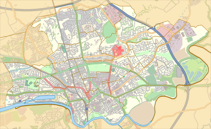
916:
Module:Location map/data/United
Kingdom Preston/doc
878:
Module:Location map/data/United
Kingdom Preston/doc
848:St Michael and All Angels Church, Ashton-on-Ribble
901:وحدة:Location map/data/United Kingdom Preston/شرح
911:Module:Location map/data/United Kingdom Preston
873:Module:Location map/data/United Kingdom Preston
378:https://creativecommons.org/licenses/by-sa/4.0
94:
896:وحدة:Location map/data/United Kingdom Preston
384:Creative Commons Attribution-Share Alike 4.0
302:
289:http://opendatacommons.org/licenses/odbl/1.0/
178:
136:
216:
188:
139:Location map United Kingdom Preston 2012.svg
14:
344:– to copy, distribute and transmit the work
46:Size of this PNG preview of this SVG file:
838:St Mary Magdalene's Church, Ribbleton
888:The following other wikis use this file:
813:St Andrew's Church, Ashton-on-Ribble
325:Attribution-Share Alike 4.0 International
222:Preston UK ward map 2010 (blank).svg:
125:
268:, which is made available under the
264:This work contains information from
226:, created using Ordnance Survey data
195:Preston UK ward map 2010 (blank).svg
658:User created page with UploadWizard
599:
313:
308:
13:
926:
414:
408:
299:
143:
126:
76:
960:
933:
413:
823:St Joseph's Church, Preston
667:
399:
355:Under the following conditions:
320:This file is licensed under the
312:
307:
301:
255:
198:
93:
31:
21:
853:St Thomas' Church, Preston
723:Deepdale Street railway station
396:
144:
883:
833:St Mary's Church, Preston
828:St Luke's Church, Preston
603:
395:
153:, England, from April 2012.
149:Map of the unparished area of
26:
1:
193:This file was derived from:
36:
663:
421:Items portrayed in this file
270:Open Database License (ODbL)
254:
247:
7:
923:
10:
965:
907:Usage on si.wikipedia.org
892:Usage on ar.wikipedia.org
843:St Matthew's, Preston
768:Moor Park Methodist Church
369:same or compatible license
231:OpenStreetMap contributors
133:
128:
818:St George's, Preston
793:Ribbleton railway station
600:
16:
733:Emmanuel Church, Preston
728:Deepdale railway station
398:
335:
100:This is a file from the
41:
783:Preston Royal Infirmary
657:
636:22:53, 26 November 2015
181:
104:. Information from its
803:Royal Preston Hospital
708:College (Preston ward)
698:Christ Church, Fulwood
151:en:Preston, Lancashire
107:description page there
283:Open Database License
858:Transport in Preston
278:CC-BY-SA-2.0 license
158:Geographic limits:
70:2,560 × 1,568 pixels
773:Preston, Lancashire
748:Greyfriars, Preston
688:Brookfield, Preston
350:– to adapt the work
210:accessed 2013-01-18
52:Other resolutions:
763:Moor Park, Preston
753:Kimberley Barracks
693:Cadley, Lancashire
66:1,280 × 784 pixels
62:1,024 × 627 pixels
952:
951:
884:Global file usage
718:Deepdale, Preston
661:
495:copyright license
481:copyright license
407:
298:
297:
281:
244:
243:
235:derivative work:
122:
121:
102:Wikimedia Commons
32:Global file usage
956:
934:
758:Larches, Preston
743:Fulwood Barracks
673:Ashton-on-Ribble
648:
610:
550:26 November 2015
451:copyright status
437:copyright status
405:
391:
388:
385:
382:
379:
371:as the original.
333:
322:Creative Commons
316:
315:
311:
310:
305:
304:
293:
290:
287:
284:
275:
259:
252:
202:
184:
183:26 November 2015
171:South: 53.747° N
168:North: 53.802° N
148:
140:
134:
118:
97:
96:
90:
84:
73:
58:640 × 392 pixels
54:320 × 196 pixels
48:733 × 449 pixels
964:
963:
959:
958:
957:
955:
954:
953:
922:
882:
778:Preston College
738:Fernyhalgh Wood
669:
662:
654:
646:
602:
601:
598:
597:
596:
595:
594:
593:
592:
591:
589:
579:
578:
577:
575:
560:
559:
558:
557:
556:
555:
554:
553:
551:
541:
540:
539:
537:
522:
521:
520:
519:
518:
517:
516:
515:
513:
501:
500:
499:
497:
478:
477:
476:
475:
474:
473:
472:
471:
469:
457:
456:
455:
453:
434:
433:
432:
431:
430:
428:
412:
411:
410:
393:
392:
389:
386:
383:
380:
377:
376:
334:
331:
328:
317:
291:
288:
285:
282:
250:
245:
229:OpenStreetMap:
174:
138:
131:
124:
123:
112:
111:
110:is shown below.
86:
82:
75:
74:
51:
12:
11:
5:
962:
950:
949:
946:
942:
941:
938:
925:
921:
920:
919:
918:
913:
905:
904:
903:
898:
885:
881:
880:
875:
870:
865:
860:
855:
850:
845:
840:
835:
830:
825:
820:
815:
810:
805:
800:
795:
790:
785:
780:
775:
770:
765:
760:
755:
750:
745:
740:
735:
730:
725:
720:
715:
710:
705:
700:
695:
690:
685:
680:
675:
665:
660:
659:
656:
652:
649:
643:
638:
633:
629:
628:
625:
622:
619:
616:
613:
605:
590:
587:
585:
584:
583:
581:
580:
576:
571:
569:
568:
567:
566:
564:
552:
549:
547:
546:
545:
543:
542:
538:
533:
531:
530:
529:
528:
526:
514:
509:
507:
506:
505:
503:
502:
498:
493:
491:
490:
489:
488:
486:
482:
470:
465:
463:
462:
461:
459:
458:
454:
449:
447:
446:
445:
444:
442:
438:
429:
424:
422:
419:
418:
417:
416:
404:
403:
400:
397:
375:
374:
373:
372:
362:
353:
352:
351:
345:
338:You are free:
329:
319:
318:
300:
296:
295:
262:
260:
249:
246:
242:
241:
240:
239:
233:
227:
218:
214:
213:
212:
211:
190:
186:
185:
180:
176:
175:
173:
172:
169:
166:
165:East: 2.620° W
163:
162:West: 2.770° W
141:
132:
130:
127:
120:
119:
98:
88:
87:
45:
40:
39:
34:
29:
24:
19:
9:
6:
4:
3:
2:
961:
947:
944:
943:
939:
936:
935:
932:
929:
917:
914:
912:
909:
908:
906:
902:
899:
897:
894:
893:
891:
890:
889:
879:
876:
874:
871:
869:
866:
864:
861:
859:
856:
854:
851:
849:
846:
844:
841:
839:
836:
834:
831:
829:
826:
824:
821:
819:
816:
814:
811:
809:
806:
804:
801:
799:
796:
794:
791:
789:
786:
784:
781:
779:
776:
774:
771:
769:
766:
764:
761:
759:
756:
754:
751:
749:
746:
744:
741:
739:
736:
734:
731:
729:
726:
724:
721:
719:
716:
714:
711:
709:
706:
704:
701:
699:
696:
694:
691:
689:
686:
684:
681:
679:
676:
674:
671:
670:
655:
650:
644:
642:
639:
637:
634:
631:
630:
626:
623:
620:
617:
614:
612:
611:
609:
588:image/svg+xml
586:
574:
570:
548:
536:
532:
512:
508:
496:
492:
468:
464:
452:
448:
427:
423:
420:
401:
394:
381:CC BY-SA 4.0
370:
366:
363:
360:
357:
356:
354:
349:
346:
343:
340:
339:
337:
336:
330:Attribution:
326:
323:
306:
294:
279:
273:
271:
267:
266:OpenStreetMap
263:
261:
258:
253:
238:
234:
232:
228:
225:
221:
220:
219:
215:
209:
206:
205:
204:
203:
201:
196:
191:
187:
177:
170:
167:
164:
161:
160:
159:
156:
152:
147:
142:
135:
116:
109:
108:
103:
99:
92:
91:
85:
80:
79:Original file
71:
67:
63:
59:
55:
49:
44:
38:
35:
33:
30:
28:
25:
23:
20:
18:
15:
930:
927:
887:
868:Tulketh Hall
808:Sharoe Green
607:
604:File history
364:
358:
347:
341:
274:
192:
157:
154:
145:
115:You can help
105:
77:
22:File history
678:Ashton Park
467:copyrighted
441:copyrighted
365:share alike
359:attribution
137:Description
664:File usage
645:733 × 449
621:Dimensions
573:media type
563:media type
27:File usage
948:448.78125
798:Riversway
788:Ribbleton
647:(5.86 MB)
618:Thumbnail
615:Date/Time
535:inception
525:inception
248:Licensing
224:Nilfanion
146:English:
924:Metadata
713:Deepdale
402:Captions
348:to remix
342:to share
327:license.
37:Metadata
863:Tulketh
683:Avenham
653:Dr Greg
632:current
627:Comment
426:depicts
406:English
237:Dr Greg
197::
129:Summary
81:
945:Height
940:733.25
217:Author
189:Source
937:Width
624:User
390:true
387:true
292:true
286:ODbL
179:Date
17:File
272:.
68:|
64:|
60:|
56:|
50:.
117:.
72:.
Text is available under the Creative Commons Attribution-ShareAlike License. Additional terms may apply.

.svg)