805:"}},"text\/plain":{"en":{"":"coordinates of the point of view"}}},"{\"value\":{\"latitude\":51.82191,\"longitude\":-4.00514,\"altitude\":null,\"precision\":1.0e-5,\"globe\":\"http:\\\/\\\/www.wikidata.org\\\/entity\\\/Q2\"},\"type\":\"globecoordinate\"}":{"text\/html":{"en":{"P1259":"51\u00b049'18.88"N, 4\u00b00'18.50"W"}},"text\/plain":{"en":{"P1259":"51\u00b049'18.88\"N, 4\u00b00'18.50\"W"}}}}": -->
465:"}},"text\/plain":{"en":{"":"author name string"}}},"{\"value\":\"Nigel Davies\",\"type\":\"string\"}":{"text\/html":{"en":{"P2093":"Nigel Davies"}},"text\/plain":{"en":{"P2093":"Nigel Davies"}}},"{\"value\":{\"entity-type\":\"property\",\"numeric-id\":2699,\"id\":\"P2699\"},\"type\":\"wikibase-entityid\"}":{"text\/html":{"en":{"":"
767:"}},"text\/plain":{"en":{"":"inception"}}},"{\"value\":{\"time\":\"+2005-06-19T00:00:00Z\",\"timezone\":0,\"before\":0,\"after\":0,\"precision\":11,\"calendarmodel\":\"http:\\\/\\\/www.wikidata.org\\\/entity\\\/Q1985727\"},\"type\":\"time\"}":{"text\/html":{"en":{"P571":"19 June 2005"}},"text\/plain":{"en":{"P571":"19 June 2005"}}}}": -->
644:
449:
237:
258:
296:
301:
67:
105:
652:"}},"text\/plain":{"en":{"P7482":"file available on the internet"}}},"{\"value\":{\"entity-type\":\"property\",\"numeric-id\":7384,\"id\":\"P7384\"},\"type\":\"wikibase-entityid\"}":{"text\/html":{"en":{"":"
457:"}},"text\/plain":{"en":{"":"object of statement has role"}}},"{\"value\":{\"entity-type\":\"item\",\"numeric-id\":33231,\"id\":\"Q33231\"},\"type\":\"wikibase-entityid\"}":{"text\/html":{"en":{"P3831":"
668:"}},"text\/plain":{"en":{"P137":"Geograph Britain and Ireland"}}},"{\"value\":{\"entity-type\":\"property\",\"numeric-id\":973,\"id\":\"P973\"},\"type\":\"wikibase-entityid\"}":{"text\/html":{"en":{"":"
843:"}},"text\/plain":{"en":{"":"location of creation"}}},"{\"value\":{\"entity-type\":\"item\",\"numeric-id\":27556163,\"id\":\"Q27556163\"},\"type\":\"wikibase-entityid\"}":{"text\/html":{"en":{"P1071":"
887:"}},"text\/plain":{"en":{"":"media type"}}},"{\"value\":\"image\\\/jpeg\",\"type\":\"string\"}":{"text\/html":{"en":{"P1163":"image\/jpeg"}},"text\/plain":{"en":{"P1163":"image\/jpeg"}}}}": -->
604:"}},"text\/plain":{"en":{"":"copyright license"}}},"{\"value\":{\"entity-type\":\"item\",\"numeric-id\":19068220,\"id\":\"Q19068220\"},\"type\":\"wikibase-entityid\"}":{"text\/html":{"en":{"P275":"
560:"}},"text\/plain":{"en":{"":"copyright status"}}},"{\"value\":{\"entity-type\":\"item\",\"numeric-id\":50423863,\"id\":\"Q50423863\"},\"type\":\"wikibase-entityid\"}":{"text\/html":{"en":{"P6216":"
648:"}},"text\/plain":{"en":{"":"source of file"}}},"{\"value\":{\"entity-type\":\"item\",\"numeric-id\":74228490,\"id\":\"Q74228490\"},\"type\":\"wikibase-entityid\"}":{"text\/html":{"en":{"P7482":"
461:"}},"text\/plain":{"en":{"P3831":"photographer"}}},"{\"value\":{\"entity-type\":\"property\",\"numeric-id\":2093,\"id\":\"P2093\"},\"type\":\"wikibase-entityid\"}":{"text\/html":{"en":{"":"
406:"}},"text\/plain":{"en":{"":"depicts"}}},"{\"value\":{\"entity-type\":\"item\",\"numeric-id\":17742502,\"id\":\"Q17742502\"},\"type\":\"wikibase-entityid\"}":{"text\/html":{"en":{"P180":"
664:"}},"text\/plain":{"en":{"":"operator"}}},"{\"value\":{\"entity-type\":\"item\",\"numeric-id\":1503119,\"id\":\"Q1503119\"},\"type\":\"wikibase-entityid\"}":{"text\/html":{"en":{"P137":"
660:"}},"text\/plain":{"en":{"P7384":"20599"}}},"{\"value\":{\"entity-type\":\"property\",\"numeric-id\":137,\"id\":\"P137\"},\"type\":\"wikibase-entityid\"}":{"text\/html":{"en":{"":"
453:"}},"text\/plain":{"en":{"":"creator"}}},"{\"value\":{\"entity-type\":\"property\",\"numeric-id\":3831,\"id\":\"P3831\"},\"type\":\"wikibase-entityid\"}":{"text\/html":{"en":{"":"
883:
469:"}},"text\/plain":{"en":{"":"URL"}}},"{\"value\":\"https:\\\/\\\/www.geograph.org.uk\\\/profile\\\/860\",\"type\":\"string\"}":{"text\/html":{"en":{"P2699":"
656:"}},"text\/plain":{"en":{"":"geograph.org.uk image ID"}}},"{\"value\":\"20599\",\"type\":\"string\"}":{"text\/html":{"en":{"P7384":"
38:
348:– You must give appropriate credit, provide a link to the license, and indicate if changes were made. You may do so in any reasonable manner, but not in any way that suggests the licensor endorses you or your use.
220:
214:
844:
649:
605:
561:
407:
657:
973:
665:
458:
884:
840:
802:
653:
645:
557:
466:
462:
454:
764:
669:
661:
601:
450:
403:
673:
470:
1001:
608:"}},"text\/plain":{"en":{"P275":"Creative Commons Attribution-ShareAlike 2.0 Generic"}}}}": -->
192:
473:"}},"text\/plain":{"en":{"P2699":"https:\/\/www.geograph.org.uk\/profile\/860"}}}}": -->
676:"}},"text\/plain":{"en":{"P973":"https:\/\/www.geograph.org.uk\/photo\/20599"}}}}": -->
870:
699:
631:
587:
436:
230:
734:
265:
355:
514:
894:
854:
812:
712:
683:
571:
535:
522:
507:
774:
742:
727:
615:
480:
420:
117:
410:"}},"text\/plain":{"en":{"P180":"St Tybie's Church, Llandybie"}}}}": -->
78:
46:
983:
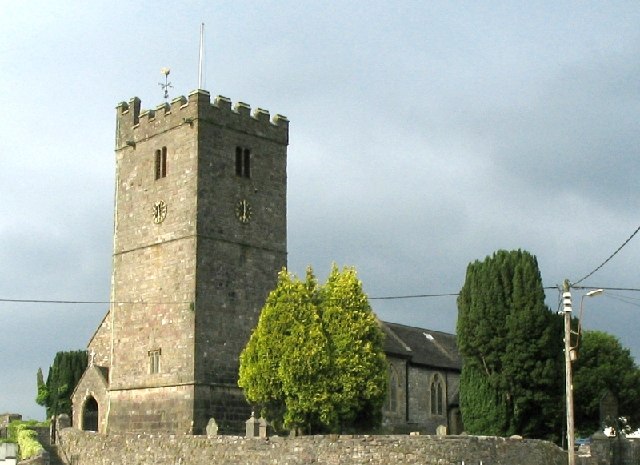
Church, Carmarthenshire, Wales. Photo originally submitted to and taken by on 19 June 2005. {{cc-by-sa-2.0}}
311:
1114:
354:– If you remix, transform, or build upon the material, you must distribute your contributions under the
272:
on the
Geograph website for the photographer's contact details. The copyright on this image is owned by
112:
564:"}},"text\/plain":{"en":{"P6216":"copyrighted"}}}}": -->
997:
The following pages on the
English Knowledge use this file (pages on other projects are not listed):
847:"}},"text\/plain":{"en":{"P1071":"Llandybie"}}}}": -->
86:
308:
749:
719:
542:
8:
252:
236:
962:
957:
37:
277:
73:
1049:
1089:
984:
181:
171:
257:
904:
864:
822:
784:
693:
625:
581:
490:
430:
148:
1006:
980:
269:
930:
Click on a date/time to view the file as it appeared at that time.
1034:
222:
1149:
215:
51° 49′ 18.88″ N, 4° 00′ 18.5″ W
104:
1104:
1044:
1024:
160:
61:
1115:
Utente:BohemianRhapsody/Lista delle comunità del Galles
396:
Add a one-line explanation of what this file represents
1129:
1119:
1094:
1079:
1069:
1139:
995:
1059:
1015:
928:
199:
Creative
Commons Attribution Share-alike license 2.0
85:
Commons is a freely licensed media file repository.
632:
Creative
Commons Attribution-ShareAlike 2.0 Generic
606:
Creative
Commons Attribution-ShareAlike 2.0 Generic
51:(640 × 465 pixels, file size: 67 KB, MIME type:
365:https://creativecommons.org/licenses/by-sa/2.0
66:
1002:Grade II* listed buildings in Carmarthenshire
371:Creative Commons Attribution-Share Alike 2.0
289:
187:
156:
135:
177:
166:
14:
674:https:\/\/www.geograph.org.uk\/photo\/20599
471:https:\/\/www.geograph.org.uk\/profile\/860
331:– to copy, distribute and transmit the work
1017:The following other wikis use this file:
750:https://www.geograph.org.uk/photo/20599
543:https://www.geograph.org.uk/profile/860
1050:Defnyddiwr:Prosiect Wici Mon/Cymunedau
229:View this and other nearby images on:
97:
276:and is licensed for reuse under the
205:
921:
312:Attribution-Share Alike 2.0 Generic
300:
295:
280:Attribution-ShareAlike 2.0 license.
13:
1146:Usage on zh-min-nan.wikipedia.org
401:
395:
286:
263:
142:
110:
98:
44:
1163:
400:
996:
813:coordinates of the point of view
803:coordinates of the point of view
386:
342:Under the following conditions:
307:This file is licensed under the
299:
294:
288:
256:
235:
221:
103:
65:
31:
21:
383:
151:Church, Carmarthenshire, Wales.
143:
41:No higher resolution available.
1012:
925:
700:file available on the internet
650:file available on the internet
382:
264:This image was taken from the
26:
1:
1090:Utilisateur:Ælfgar/Brouillon7
992:
735:Geograph Britain and Ireland
666:Geograph Britain and Ireland
508:object of statement has role
455:object of statement has role
437:St Tybie's Church, Llandybie
416:Items portrayed in this file
408:St Tybie's Church, Llandybie
248:
7:
1031:Usage on ceb.wikipedia.org
10:
1168:
1136:Usage on www.wikidata.org
1126:Usage on sv.wikipedia.org
1111:Usage on it.wikipedia.org
1101:Usage on ga.wikipedia.org
1086:Usage on fr.wikipedia.org
1076:Usage on eu.wikipedia.org
1066:Usage on es.wikipedia.org
1056:Usage on de.wikipedia.org
1041:Usage on cy.wikipedia.org
1021:Usage on br.wikipedia.org
828:51°49'18.88"N, 4°0'18.50"W
356:same or compatible license
132:
127:
99:
922:
16:
713:geograph.org.uk image ID
654:geograph.org.uk image ID
385:
322:
72:This is a file from the
36:
979:
958:01:30, 6 September 2005
159:
76:. Information from its
975:Loganberry~commonswiki
270:this photograph's page
241:51.821910; -4.005140
79:description page there
855:location of creation
841:location of creation
138:Llandybie Church.jpg
47:Llandybie_Church.jpg
1035:Llandybie (lungsod)
337:– to adapt the work
111:This is a photo of
523:author name string
463:author name string
1013:Global file usage
990:
616:copyright license
602:copyright license
394:
285:
284:
268:collection. See
246:
245:
203:
202:
196:
193:Reusing this file
125:
124:
94:
93:
74:Wikimedia Commons
32:Global file usage
1159:
970:
932:
752:
747:
743:described at URL
737:
732:
722:
717:
670:described at URL
572:copyright status
558:copyright status
545:
540:
530:
527:
517:
512:
392:
378:
375:
372:
369:
366:
358:as the original.
320:
309:Creative Commons
303:
302:
298:
297:
292:
291:
278:Creative Commons
266:Geograph project
260:
253:
242:
239:
225:
224:
218:
217:
206:
190:
162:
147:
139:
133:
107:
100:
90:
69:
68:
62:
56:
54:
1167:
1166:
1162:
1161:
1160:
1158:
1157:
1156:
1011:
998:
991:
976:
968:
924:
923:
920:
919:
918:
917:
916:
915:
914:
913:
911:
901:
900:
899:
897:
882:
881:
880:
879:
878:
877:
876:
875:
873:
861:
860:
859:
857:
838:
837:
836:
835:
834:
833:
832:
831:
829:
819:
818:
817:
815:
800:
799:
798:
797:
796:
795:
794:
793:
791:
781:
780:
779:
777:
762:
761:
760:
759:
758:
757:
756:
755:
754:
753:
748:
745:
739:
738:
733:
730:
724:
723:
718:
715:
706:
705:
704:
702:
690:
689:
688:
686:
643:
642:
641:
640:
639:
638:
637:
636:
634:
622:
621:
620:
618:
599:
598:
597:
596:
595:
594:
593:
592:
590:
578:
577:
576:
574:
555:
554:
553:
552:
551:
550:
549:
548:
547:
546:
541:
538:
532:
531:
528:
525:
519:
518:
513:
510:
501:
500:
499:
497:
487:
486:
485:
483:
448:
447:
446:
445:
444:
443:
442:
441:
439:
427:
426:
425:
423:
399:
398:
397:
380:
379:
376:
373:
370:
367:
364:
363:
321:
318:
315:
304:
281:
251:
240:
213:
212:
209:Camera location
204:
172:geograph.org.uk
152:
137:
130:
116:
113:listed building
96:
95:
84:
83:
82:is shown below.
58:
52:
50:
43:
42:
12:
11:
5:
1165:
1155:
1154:
1153:
1152:
1144:
1143:
1142:
1134:
1133:
1132:
1124:
1123:
1122:
1117:
1109:
1108:
1107:
1099:
1098:
1097:
1092:
1084:
1083:
1082:
1074:
1073:
1072:
1064:
1063:
1062:
1054:
1053:
1052:
1047:
1039:
1038:
1037:
1029:
1028:
1027:
1014:
1010:
1009:
1004:
994:
989:
988:
985:Category:Wales
978:
974:
971:
965:
960:
955:
951:
950:
947:
944:
941:
938:
935:
927:
912:
909:
907:
906:
905:
903:
902:
898:
893:
891:
890:
889:
888:
886:
874:
869:
867:
866:
865:
863:
862:
858:
853:
851:
850:
849:
848:
846:
842:
830:
827:
825:
824:
823:
821:
820:
816:
811:
809:
808:
807:
806:
804:
792:
789:
787:
786:
785:
783:
782:
778:
773:
771:
770:
769:
768:
766:
741:
740:
726:
725:
711:
710:
709:
708:
707:
703:
698:
696:
695:
694:
692:
691:
687:
684:source of file
682:
680:
679:
678:
677:
675:
671:
667:
663:
659:
655:
651:
647:
646:source of file
635:
630:
628:
627:
626:
624:
623:
619:
614:
612:
611:
610:
609:
607:
603:
591:
586:
584:
583:
582:
580:
579:
575:
570:
568:
567:
566:
565:
563:
559:
534:
533:
521:
520:
506:
505:
504:
503:
502:
498:
495:
493:
492:
491:
489:
488:
484:
479:
477:
476:
475:
474:
472:
468:
464:
460:
456:
452:
440:
435:
433:
432:
431:
429:
428:
424:
419:
417:
414:
413:
412:
411:
409:
405:
391:
390:
387:
384:
362:
361:
360:
359:
349:
340:
339:
338:
332:
325:You are free:
316:
306:
305:
287:
283:
282:
261:
250:
247:
244:
243:
233:
227:
210:
201:
200:
197:
185:
184:
179:
175:
174:
168:
164:
163:
158:
154:
153:
140:
131:
129:
126:
123:
122:
108:
92:
91:
70:
60:
59:
40:
35:
34:
29:
24:
19:
9:
6:
4:
3:
2:
1164:
1151:
1148:
1147:
1145:
1141:
1138:
1137:
1135:
1131:
1128:
1127:
1125:
1121:
1118:
1116:
1113:
1112:
1110:
1106:
1103:
1102:
1100:
1096:
1093:
1091:
1088:
1087:
1085:
1081:
1078:
1077:
1075:
1071:
1068:
1067:
1065:
1061:
1058:
1057:
1055:
1051:
1048:
1046:
1043:
1042:
1040:
1036:
1033:
1032:
1030:
1026:
1023:
1022:
1020:
1019:
1018:
1008:
1005:
1003:
1000:
999:
986:
982:
977:
972:
966:
964:
961:
959:
956:
953:
952:
948:
945:
942:
939:
936:
934:
933:
931:
908:
896:
892:
872:
868:
856:
852:
826:
814:
810:
788:
776:
772:
751:
744:
736:
729:
721:
714:
701:
697:
685:
681:
633:
629:
617:
613:
589:
585:
573:
569:
544:
537:
524:
516:
509:
494:
482:
478:
438:
434:
422:
418:
415:
388:
381:
368:CC BY-SA 2.0
357:
353:
350:
347:
344:
343:
341:
336:
333:
330:
327:
326:
324:
323:
317:Attribution:
313:
310:
293:
279:
275:
271:
267:
262:
259:
255:
254:
238:
234:
232:
231:OpenStreetMap
228:
226:
216:
211:
208:
207:
198:
194:
189:
186:
183:
180:
176:
173:
169:
165:
155:
150:
146:
141:
134:
121:
119:
114:
109:
106:
102:
101:
88:
81:
80:
75:
71:
64:
63:
57:
48:
39:
33:
30:
28:
25:
23:
20:
18:
15:
1016:
929:
926:File history
790:19 June 2005
529:Nigel Davies
515:photographer
459:photographer
351:
345:
334:
328:
319:Nigel Davies
274:Nigel Davies
273:
182:Nigel Davies
161:19 June 2005
144:
87:You can help
77:
45:
22:File history
981:w:Llandybie
588:copyrighted
562:copyrighted
352:share alike
346:attribution
136:Description
993:File usage
967:640 × 465
943:Dimensions
910:image/jpeg
895:media type
885:media type
496:some value
188:Permission
53:image/jpeg
27:File usage
1150:Llandybie
1130:Llandybie
1120:Llandybie
1105:Llandybïe
1095:Llandybie
1080:Llandybie
1070:Llandybie
1045:Llandybïe
1025:Llandybïe
1007:Llandybie
940:Thumbnail
937:Date/Time
871:Llandybie
845:Llandybie
775:inception
765:inception
249:Licensing
149:Llandybie
145:English:
1140:Q6661267
728:operator
662:operator
389:Captions
335:to remix
329:to share
314:license.
1060:Tudclyd
969:(67 KB)
954:current
949:Comment
481:creator
451:creator
421:depicts
404:depicts
393:English
128:Summary
49:
219:
178:Author
167:Source
115:number
720:20599
658:20599
170:From
118:10915
946:User
377:true
374:true
157:Date
17:File
536:URL
467:URL
746::
731::
716::
539::
526::
511::
987:[
195:)
191:(
120:.
89:.
55:)
