726:"}},"text\/plain":{"en":{"":"coordinates of the point of view"}}},"{\"value\":{\"latitude\":18.550618,\"longitude\":122.153328,\"altitude\":null,\"precision\":1.0e-6,\"globe\":\"http:\\\/\\\/www.wikidata.org\\\/entity\\\/Q2\"},\"type\":\"globecoordinate\"}":{"text\/html":{"en":{"P1259":"18\u00b033'2.225"N, 122\u00b09'11.981"E"}},"text\/plain":{"en":{"P1259":"18\u00b033'2.225\"N, 122\u00b09'11.981\"E"}}},"{\"value\":{\"entity-type\":\"property\",\"numeric-id\":7787,\"id\":\"P7787\"},\"type\":\"wikibase-entityid\"}":{"text\/html":{"en":{"":"
514:"}},"text\/plain":{"en":{"":"author name string"}}},"{\"value\":\"Ervin Malicdem\",\"type\":\"string\"}":{"text\/html":{"en":{"P2093":"Ervin Malicdem"}},"text\/plain":{"en":{"P2093":"Ervin Malicdem"}}},"{\"value\":{\"entity-type\":\"property\",\"numeric-id\":4174,\"id\":\"P4174\"},\"type\":\"wikibase-entityid\"}":{"text\/html":{"en":{"":"
838:"}},"text\/plain":{"en":{"":"inception"}}},"{\"value\":{\"time\":\"+2013-03-27T00:00:00Z\",\"timezone\":0,\"before\":0,\"after\":0,\"precision\":11,\"calendarmodel\":\"http:\\\/\\\/www.wikidata.org\\\/entity\\\/Q1985727\"},\"type\":\"time\"}":{"text\/html":{"en":{"P571":"27 March 2013"}},"text\/plain":{"en":{"P571":"27 March 2013"}}}}": -->
43:
506:
435:
427:
722:
449:
264:
355:
269:
665:"}},"text\/plain":{"en":{"P275":"Creative Commons Attribution-ShareAlike 4.0 International"}}},"{\"value\":{\"entity-type\":\"item\",\"numeric-id\":50829104,\"id\":\"Q50829104\"},\"type\":\"wikibase-entityid\"}":{"text\/html":{"en":{"P275":"
99:
661:"}},"text\/plain":{"en":{"":"copyright license"}}},"{\"value\":{\"entity-type\":\"item\",\"numeric-id\":18199165,\"id\":\"Q18199165\"},\"type\":\"wikibase-entityid\"}":{"text\/html":{"en":{"P275":"
617:"}},"text\/plain":{"en":{"":"copyright status"}}},"{\"value\":{\"entity-type\":\"item\",\"numeric-id\":50423863,\"id\":\"Q50423863\"},\"type\":\"wikibase-entityid\"}":{"text\/html":{"en":{"P6216":"
794:"}},"text\/plain":{"en":{"":"source of file"}}},"{\"value\":{\"entity-type\":\"item\",\"numeric-id\":66458942,\"id\":\"Q66458942\"},\"type\":\"wikibase-entityid\"}":{"text\/html":{"en":{"P7482":"
730:"}},"text\/plain":{"en":{"":"heading"}}},"{\"value\":{\"amount\":\"+282\",\"unit\":\"http:\\\/\\\/www.wikidata.org\\\/entity\\\/Q28390\"},\"type\":\"quantity\"}":{"text\/html":{"en":{"P7787":"282
522:"}},"text\/plain":{"en":{"P4174":"Schadow1"}}},"{\"value\":{\"entity-type\":\"property\",\"numeric-id\":2699,\"id\":\"P2699\"},\"type\":\"wikibase-entityid\"}":{"text\/html":{"en":{"":"
510:"}},"text\/plain":{"en":{"":"creator"}}},"{\"value\":{\"entity-type\":\"property\",\"numeric-id\":2093,\"id\":\"P2093\"},\"type\":\"wikibase-entityid\"}":{"text\/html":{"en":{"":"
790:
393:
This attribution requirement is provided pursuant to the
Creative Commons Attribution-ShareAlike mechanism where "you must attribute the work in the manner specified by the author or licensor (but not in any way that suggests that they endorse you or your use of the work.) And if you remix the work,
526:"}},"text\/plain":{"en":{"":"URL"}}},"{\"value\":\"https:\\\/\\\/commons.wikimedia.org\\\/wiki\\\/user:Schadow1\",\"type\":\"string\"}":{"text\/html":{"en":{"P2699":"
518:"}},"text\/plain":{"en":{"":"Wikimedia username"}}},"{\"value\":\"Schadow1\",\"type\":\"string\"}":{"text\/html":{"en":{"P4174":"
310:– You must give appropriate credit, provide a link to the license, and indicate if changes were made. You may do so in any reasonable manner, but not in any way that suggests the licensor endorses you or your use.
153:
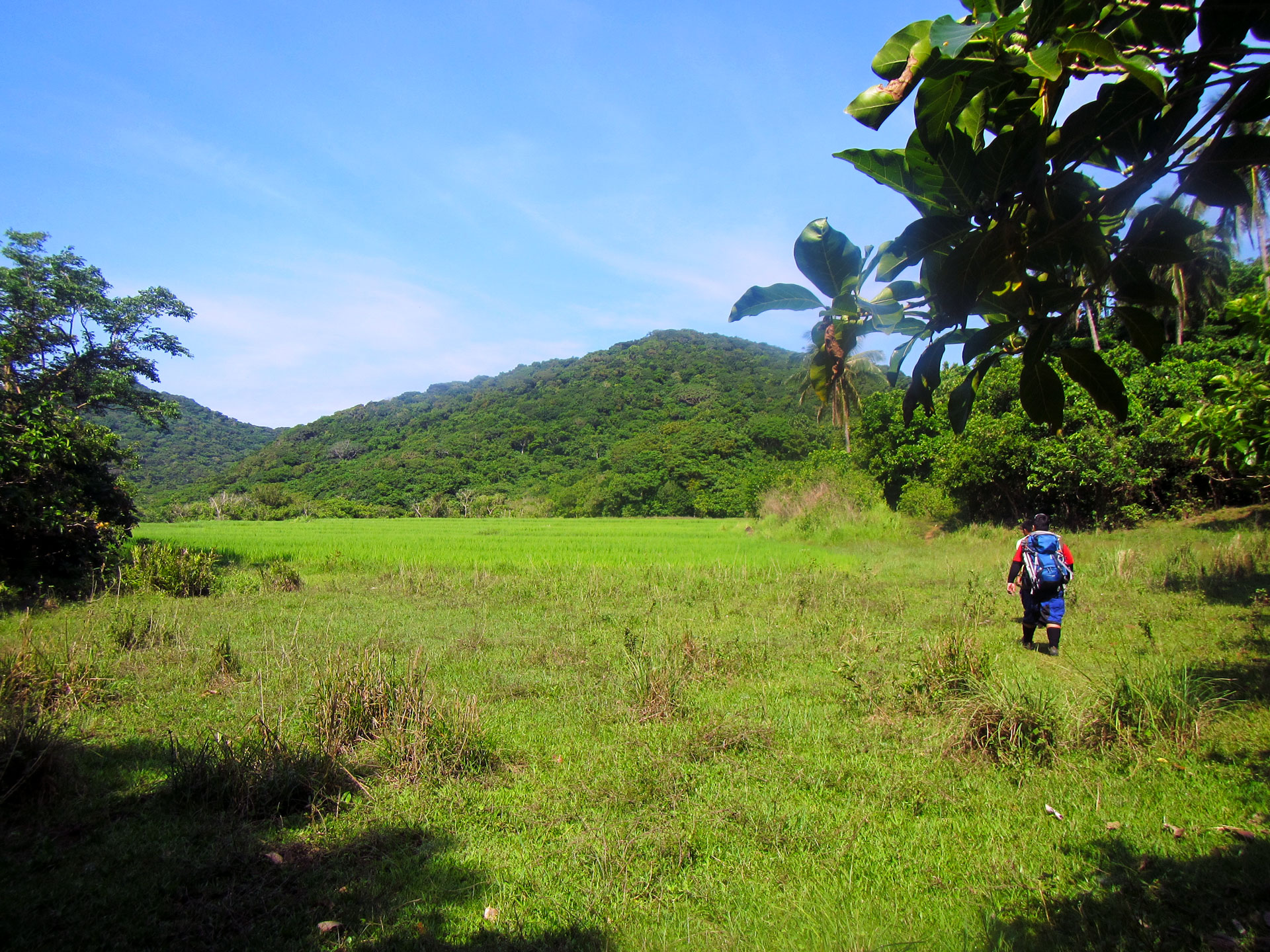
Grassland and mountain trekking at
Cagayan Valley's Palaui Island to reach the famous Cape Engano, Luzon's northeastern tip frontier. Shot by Schadow1 Expeditions during its mapping expedition of the island last
432:
418:
519:
368:, would like you to attribute the work to him (among other requirements such as indicating that the work is licensed under the Creative Commons) with the following text or similar:
795:
666:
662:
618:
527:
791:
727:
723:
614:
523:
515:
511:
835:
658:
507:
381:. If a link is not possible, then the url should be placed in parentheses after the name. If the work has been substantially altered by other people (see the
230:
65:
61:
57:
53:
47:
110:
78:
945:
530:"}},"text\/plain":{"en":{"P2699":"https:\/\/commons.wikimedia.org\/wiki\/user:Schadow1"}}}}": -->
669:"}},"text\/plain":{"en":{"P275":"GNU Free Documentation License, version 1.2 or later"}}}}": -->
228:; with no Invariant Sections, no Front-Cover Texts, and no Back-Cover Texts. A copy of the license is included in the section entitled
194:
821:
709:
692:
644:
442:
976:
This file contains additional information, probably added from the digital camera or scanner used to create or digitize it.
317:
805:
768:
741:
628:
592:
577:
564:
798:"}},"text\/plain":{"en":{"P7482":"original creation by uploader"}}}}": -->
220:
845:
676:
537:
496:
963:
1119:
584:
279:
979:
If the file has been modified from its original state, some details may not fully reflect the modified file.
225:
316:– If you remix, transform, or build upon the material, you must distribute your contributions under the
913:
908:
621:"}},"text\/plain":{"en":{"P6216":"copyrighted"}}}}": -->
69:
42:
941:
The following pages on the
English Knowledge use this file (pages on other projects are not listed):
734:"}},"text\/plain":{"en":{"P7787":"282 degree"}}}}": -->
389:
attribution requirement is waived, which means you can attribute the work in any reasonable manner.
118:
461:
599:
1177:
218:
Permission is granted to copy, distribute and/or modify this document under the terms of the
360:
If you choose to use this work under the
Creative Commons license stated above, the author,
276:
8:
1205:
998:
448:
204:
I, the copyright holder of this work, hereby publish it under the following licenses:
105:
486:
988:
378:
371:
363:
183:
395:
1289:
1195:
1159:
1005:
924:
1299:
1045:
855:
815:
751:
703:
686:
638:
547:
1223:
1025:
207:
1015:
964:
Nasalakniban a
Ladawan ti daga ken Ladawan ti baybay ti Isla Palaui
881:
Click on a date/time to view the file as it appeared at that time.
163:
460:
Initially published at
Schadow1 Expeditions article available at
419:
18° 33′ 02.22″ N, 122° 09′ 11.98″ E
434:
354:
462:
http://www.s1expeditions.com/2013/04/060-palaui-cagayan.html
693:
Creative
Commons Attribution-ShareAlike 4.0 International
663:
Creative
Commons Attribution-ShareAlike 4.0 International
93:
480:
Add a one-line explanation of what this file represents
939:
83:(1,920 × 1,440 pixels, file size: 862 KB, MIME type:
954:
879:
710:
667:
528:
https:\/\/commons.wikimedia.org\/wiki\/user:Schadow1
394:
it must be distributed with the same license." (See
224:, Version 1.2 or any later version published by the
117:
Commons is a freely licensed media file repository.
1210:Flash did not fire, compulsory flash suppression
349:
946:Palaui Island Protected Landscape and Seascape
327:https://creativecommons.org/licenses/by-sa/4.0
98:
333:Creative Commons Attribution-Share Alike 4.0
257:
189:
159:
140:
179:
169:
14:
731:
600:https://commons.wikimedia.org/user:Schadow1
293:– to copy, distribute and transmit the work
345:You may select the license of your choice.
956:The following other wikis use this file:
280:Attribution-Share Alike 4.0 International
441:View this and other nearby images on:
129:
409:
236:http://www.gnu.org/copyleft/fdl.html
931:User created page with UploadWizard
872:
268:
263:
143:Leonardo Trail at Palaui Island.jpg
13:
974:
485:
479:
344:
254:
203:
147:
130:
76:
1365:
981:
484:
398:in the Creative Commons website.)
1036:Date and time of data generation
940:
742:coordinates of the point of view
724:coordinates of the point of view
470:
447:
433:
425:
382:
353:
304:Under the following conditions:
275:This file is licensed under the
267:
262:
256:
212:
211:
97:
31:
21:
467:
148:
951:
876:
466:
379:his Wikimedia Commons userpage
242:GNU Free Documentation License
231:GNU Free Documentation License
221:GNU Free Documentation License
26:
1:
822:original creation by uploader
796:original creation by uploader
757:18°33'2.225"N, 122°9'11.981"E
377:His name should be a link to
36:
1190:3.9269482450922 APEX (f/3.9)
936:
492:Items portrayed in this file
424:
7:
1249:Focal plane resolution unit
1130:Date and time of digitizing
1074:19.6 meters above sea level
971:
960:Usage on ilo.wikipedia.org
10:
1370:
1260:One-chip color area sensor
1215:Supported Flashpix version
318:same or compatible license
137:
132:
1334:Geodetic survey data used
1138:Meaning of each component
1103:File change date and time
873:
173:
16:
1241:Focal plane Y resolution
1233:Focal plane X resolution
469:
284:
226:Free Software Foundation
104:This is a file from the
41:
1329:Measurement in progress
1318:GPS time (atomic clock)
1273:Custom image processing
930:
164:27 March 2013, 09:26:46
162:
108:. Information from its
909:17:14, 17 January 2015
453:18.550618; 122.153328
111:description page there
46:Size of this preview:
1187:Maximum land aperture
1087:Horizontal resolution
1268:Digital still camera
1133:09:26, 27 March 2013
1106:09:26, 27 March 2013
1039:09:26, 27 March 2013
383:File history section
70:1,920 × 1,440 pixels
1111:Y and C positioning
1095:Vertical resolution
999:Canon PowerShot D20
985:Camera manufacturer
299:– to adapt the work
52:Other resolutions:
1310:Scene capture type
1294:Auto white balance
578:Wikimedia username
565:author name string
516:Wikimedia username
512:author name string
385:below), then this
66:1,280 × 960 pixels
62:1,024 × 768 pixels
1357:
1356:
1010:1/500 sec (0.002)
952:Global file usage
934:
733:
677:copyright license
659:copyright license
478:
458:
457:
407:
406:
403:
402:
253:
252:
198:
195:Reusing this file
126:
125:
106:Wikimedia Commons
32:Global file usage
1361:
1244:16,393.442622951
1236:16,393.442622951
1066:122° 9′ 11.98″ E
982:
921:
883:
779:
778:
773:
629:copyright status
615:copyright status
602:
597:
587:
582:
572:
569:
476:
454:
451:
437:
436:
430:
429:
428:
422:
421:
410:
362:Ervin Malicdem (
357:
356:
350:
340:
337:
334:
331:
328:
320:as the original.
277:Creative Commons
271:
270:
266:
265:
260:
259:
249:
246:
243:
240:
237:
215:
214:
208:
192:
175:
165:
152:
144:
138:
122:
101:
100:
94:
88:
86:
73:
58:640 × 480 pixels
54:320 × 240 pixels
48:800 × 600 pixels
1369:
1368:
1364:
1363:
1362:
1360:
1359:
1358:
1350:GPS tag version
1326:Receiver status
1172:3.9269482450922
1164:8.9686668031948
1058:18° 33′ 2.22″ N
970:
950:
942:
935:
927:
919:
875:
874:
871:
870:
869:
868:
867:
866:
865:
864:
862:
852:
851:
850:
848:
833:
832:
831:
830:
829:
828:
827:
826:
824:
812:
811:
810:
808:
789:
788:
787:
786:
785:
784:
783:
782:
781:
780:
776:
774:
771:
762:
761:
760:
758:
748:
747:
746:
744:
721:
720:
719:
718:
717:
716:
715:
714:
712:
701:
700:
699:
698:
697:
695:
683:
682:
681:
679:
656:
655:
654:
653:
652:
651:
650:
649:
647:
635:
634:
633:
631:
612:
611:
610:
609:
608:
607:
606:
605:
604:
603:
598:
595:
589:
588:
583:
580:
574:
573:
570:
567:
558:
557:
556:
554:
544:
543:
542:
540:
505:
504:
503:
502:
501:
499:
483:
482:
481:
452:
426:
417:
416:
413:Camera location
408:
399:
375:
348:
347:
346:
342:
341:
338:
335:
332:
329:
326:
325:
283:
272:
247:
244:
241:
238:
235:
206:
205:
155:
142:
135:
128:
127:
116:
115:
114:is shown below.
90:
84:
82:
75:
74:
51:
12:
11:
5:
1367:
1355:
1354:
1351:
1347:
1346:
1343:
1339:
1338:
1335:
1331:
1330:
1327:
1323:
1322:
1319:
1315:
1314:
1311:
1307:
1306:
1303:
1296:
1295:
1292:
1286:
1285:
1282:
1278:
1277:
1276:Normal process
1274:
1270:
1269:
1266:
1262:
1261:
1258:
1257:Sensing method
1254:
1253:
1250:
1246:
1245:
1242:
1238:
1237:
1234:
1230:
1229:
1226:
1220:
1219:
1216:
1212:
1211:
1208:
1202:
1201:
1198:
1192:
1191:
1188:
1184:
1183:
1180:
1174:
1173:
1170:
1166:
1165:
1162:
1156:
1155:
1154:
1153:
1152:does not exist
1150:
1147:
1144:
1139:
1135:
1134:
1131:
1127:
1126:
1123:
1116:
1115:
1112:
1108:
1107:
1104:
1100:
1099:
1096:
1092:
1091:
1088:
1084:
1083:
1080:
1076:
1075:
1072:
1068:
1067:
1064:
1060:
1059:
1056:
1052:
1051:
1048:
1041:
1040:
1037:
1033:
1032:
1029:
1022:
1021:
1018:
1012:
1011:
1008:
1002:
1001:
996:
992:
991:
986:
973:
969:
968:
967:
966:
953:
949:
948:
938:
933:
932:
929:
925:
922:
918:1,920 × 1,440
916:
911:
906:
902:
901:
898:
895:
892:
889:
886:
878:
863:
860:
858:
857:
856:
854:
853:
849:
844:
842:
841:
840:
839:
837:
825:
820:
818:
817:
816:
814:
813:
809:
806:source of file
804:
802:
801:
800:
799:
797:
793:
792:source of file
767:
766:
765:
764:
763:
759:
756:
754:
753:
752:
750:
749:
745:
740:
738:
737:
736:
735:
729:
725:
713:
708:
706:
705:
704:
702:
696:
691:
689:
688:
687:
685:
684:
680:
675:
673:
672:
671:
670:
668:
664:
660:
648:
643:
641:
640:
639:
637:
636:
632:
627:
625:
624:
623:
622:
620:
616:
591:
590:
576:
575:
571:Ervin Malicdem
563:
562:
561:
560:
559:
555:
552:
550:
549:
548:
546:
545:
541:
536:
534:
533:
532:
531:
529:
525:
521:
517:
513:
509:
500:
495:
493:
490:
489:
488:
487:
475:
474:
471:
468:
456:
455:
445:
439:
414:
405:
404:
401:
400:
392:
372:Ervin Malicdem
369:
358:
343:
324:
323:
322:
321:
311:
302:
301:
300:
294:
287:You are free:
274:
273:
255:
251:
250:
216:
202:
201:
199:
187:
186:
184:Ervin Malicdem
181:
177:
176:
171:
167:
166:
161:
157:
156:
145:
136:
134:
131:
124:
123:
102:
92:
91:
45:
40:
39:
34:
29:
24:
19:
9:
6:
4:
3:
2:
1366:
1352:
1349:
1348:
1345:27 March 2013
1344:
1341:
1340:
1336:
1333:
1332:
1328:
1325:
1324:
1320:
1317:
1316:
1312:
1309:
1308:
1304:
1301:
1298:
1297:
1293:
1291:
1290:White balance
1288:
1287:
1284:Auto exposure
1283:
1281:Exposure mode
1280:
1279:
1275:
1272:
1271:
1267:
1264:
1263:
1259:
1256:
1255:
1251:
1248:
1247:
1243:
1240:
1239:
1235:
1232:
1231:
1227:
1225:
1222:
1221:
1217:
1214:
1213:
1209:
1207:
1204:
1203:
1199:
1197:
1196:Metering mode
1194:
1193:
1189:
1186:
1185:
1181:
1179:
1178:Exposure bias
1176:
1175:
1171:
1169:APEX aperture
1168:
1167:
1163:
1161:
1160:Shutter speed
1158:
1157:
1151:
1148:
1145:
1142:
1141:
1140:
1137:
1136:
1132:
1129:
1128:
1124:
1121:
1118:
1117:
1113:
1110:
1109:
1105:
1102:
1101:
1097:
1094:
1093:
1089:
1086:
1085:
1081:
1078:
1077:
1073:
1070:
1069:
1065:
1062:
1061:
1057:
1054:
1053:
1049:
1047:
1043:
1042:
1038:
1035:
1034:
1030:
1027:
1024:
1023:
1019:
1017:
1014:
1013:
1009:
1007:
1006:Exposure time
1004:
1003:
1000:
997:
994:
993:
990:
987:
984:
983:
980:
977:
965:
962:
961:
959:
958:
957:
947:
944:
943:
928:
923:
917:
915:
912:
910:
907:
904:
903:
899:
896:
893:
890:
887:
885:
884:
882:
861:27 March 2013
859:
847:
843:
823:
819:
807:
803:
770:
755:
743:
739:
711:
707:
694:
690:
678:
674:
646:
642:
630:
626:
601:
594:
586:
579:
566:
551:
539:
535:
498:
494:
491:
472:
465:
464:
463:
450:
446:
444:
443:OpenStreetMap
440:
438:
420:
415:
412:
411:
397:
396:"Attribution"
391:
390:
388:
384:
380:
373:
367:
365:
359:
352:
351:
330:CC BY-SA 4.0
319:
315:
312:
309:
306:
305:
303:
298:
295:
292:
289:
288:
286:
285:
281:
278:
261:
233:
232:
227:
223:
222:
217:
210:
209:
200:
196:
191:
188:
185:
182:
178:
172:
168:
158:
151:
146:
139:
120:
113:
112:
107:
103:
96:
95:
89:
80:
79:Original file
71:
67:
63:
59:
55:
49:
44:
38:
35:
33:
30:
28:
25:
23:
20:
18:
15:
1300:Digital zoom
1046:focal length
995:Camera model
978:
975:
955:
880:
877:File history
459:
423:
386:
376:
361:
313:
307:
296:
290:
229:
219:
149:
119:You can help
109:
77:
22:File history
1265:File source
1224:Color space
1079:Orientation
645:copyrighted
619:copyrighted
314:share alike
308:attribution
141:Description
937:File usage
894:Dimensions
553:some value
387:particular
190:Permission
85:image/jpeg
27:File usage
1063:Longitude
1026:ISO speed
891:Thumbnail
888:Date/Time
846:inception
836:inception
150:English:
1342:GPS date
1313:Standard
1114:Centered
1071:Altitude
1055:Latitude
1016:F-number
972:Metadata
926:Schadow1
920:(862 KB)
585:Schadow1
520:Schadow1
473:Captions
364:schadow1
297:to remix
291:to share
282:license.
174:Own work
37:Metadata
1353:0.0.3.2
1200:Pattern
1122:version
1098:180 dpi
1090:180 dpi
905:current
900:Comment
769:heading
728:heading
538:creator
508:creator
497:depicts
477:English
374:, 2013.
133:Summary
81:
1337:WGS-84
1252:inches
1082:Normal
1028:rating
777:degree
732:degree
431:
180:Author
170:Source
1321:01:26
1302:ratio
1206:Flash
1044:Lens
1020:f/3.9
989:Canon
154:2013.
1228:sRGB
1120:Exif
1050:5 mm
897:User
775:282
339:true
336:true
248:true
245:true
239:GFDL
160:Date
17:File
1125:2.3
1031:100
593:URL
524:URL
1149:Cr
1146:Cb
772::
596::
581::
568::
370:©
68:|
64:|
60:|
56:|
50:.
1305:1
1218:1
1182:0
1143:Y
366:)
234:.
197:)
193:(
121:.
87:)
72:.
Text is available under the Creative Commons Attribution-ShareAlike License. Additional terms may apply.