330:"}},"text\/plain":{"en":{"":"inception"}}},"{\"value\":{\"time\":\"+2008-02-01T00:00:00Z\",\"timezone\":0,\"before\":0,\"after\":0,\"precision\":10,\"calendarmodel\":\"http:\\\/\\\/www.wikidata.org\\\/entity\\\/Q1985727\"},\"type\":\"time\"}":{"text\/html":{"en":{"P571":"February 2008"}},"text\/plain":{"en":{"P571":"February 2008"}}}}": -->
241:
253:
205:
91:
43:
326:
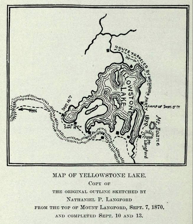
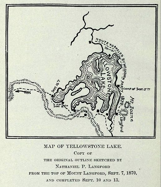
423:{{Information |Description=Map of Yellowstone Lake, 1870 Washburn, Doane and Langford Expedition |Source=Extracted from Public Domain PDF File of DIARY OF THE WASHBURN EXPEDITION TO THE YELLOWSTONE AND FIREHOLE RIVERS IN THE YEAR 1870 BY NATHANIEL PITT LA
467:
267:
for US works, such as Canada, Mainland China (not Hong Kong or Macao), Germany, Mexico, and
Switzerland. The creator and year of publication are essential information and must be provided. See
327:
263:
This image might not be in the public domain outside of the United States; this especially applies in the countries and areas that do not apply the
57:
53:
47:
102:
452:
70:
158:
Extracted from Public Domain PDF File of DIARY OF THE WASHBURN EXPEDITION TO THE YELLOWSTONE AND FIREHOLE RIVERS IN THE YEAR 1870 BY
553:
This file contains additional information, probably added from the digital camera or scanner used to create or digitize it.
337:
316:
462:
556:
If the file has been modified from its original state, some details may not fully reflect the modified file.
520:
264:
433:
The following pages on the
English Knowledge use this file (pages on other projects are not listed):
268:
110:
405:
400:
61:
42:
442:
530:
272:
230:
468:
User talk:Mike Cline/Articles Under
Contemplation/The Discovery of Yellowstone Park (1870)
8:
229:
occurred prior to
January 1, 1929, and if not then due to lack of notice or renewal. See
225:. This applies to U.S. works where the copyright has expired, often because its first
97:
306:
457:
416:
495:
447:
222:
217:
226:
437:
347:
540:
485:
139:
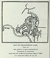
Map of
Yellowstone Lake, 1870 Washburn, Doane and Langford Expedition
373:
Click on a date/time to view the file as it appeared at that time.
85:
500:
510:
300:
Add a one-line explanation of what this file represents
160:
NATHANIEL PITT LANGFORD (1905), on the
Internet Archive
147:
431:
476:
371:
109:
Commons is a freely licensed media file repository.
75:(653 × 757 pixels, file size: 113 KB, MIME type:
90:
143:
132:
164:
153:
14:
478:The following other wikis use this file:
240:
204:
121:
199:
364:
13:
551:
496:Washburn-Langford-Doane-Expedition
453:Washburn–Langford–Doane Expedition
305:
299:
262:
251:
239:
213:
203:
122:
68:
577:
558:
531:Washburn–Langford–Doane expeditie
463:User:Revoman~enwiki/Shoshone Lake
304:
432:
290:
89:
31:
21:
287:
473:
368:
286:
135:LangfordYellowstoneLakeMap.JPG
26:
1:
36:
428:
312:Items portrayed in this file
175:
7:
548:
10:
582:
537:Usage on tr.wikipedia.org
527:Usage on nl.wikipedia.org
517:Usage on he.wikipedia.org
507:Usage on fr.wikipedia.org
492:Usage on de.wikipedia.org
482:Usage on az.wikipedia.org
215:This media file is in the
129:
124:
365:
16:
289:
265:rule of the shorter term
233:for further explanation.
96:This is a file from the
41:
422:
401:01:53, 12 February 2008
269:Knowledge:Public domain
146:
100:. Information from its
443:First Peoples Mountain
256:
245:
209:
103:description page there
46:Size of this preview:
255:
243:
207:
273:Knowledge:Copyrights
52:Other resolutions:
257:
246:
210:
569:
568:
474:Global file usage
426:
298:
284:
283:
277:
275:for more details.
198:
197:
172:
171:
118:
117:
98:Wikimedia Commons
32:Global file usage
573:
559:
541:Yellowstone Gölü
458:Yellowstone Lake
413:
375:
296:
278:
261:
254:
242:
206:
200:
194:
191:
188:
185:
180:
179:
149:
136:
130:
114:
93:
92:
86:
80:
78:
65:
62:653 × 757 pixels
58:414 × 480 pixels
54:207 × 240 pixels
48:517 × 599 pixels
581:
580:
576:
575:
574:
572:
571:
570:
547:
486:Yellouston gölü
472:
434:
427:
419:
411:
367:
366:
363:
362:
361:
360:
359:
358:
357:
356:
354:
344:
343:
342:
340:
325:
324:
323:
322:
321:
319:
303:
302:
301:
276:
260:
252:
235:
192:
189:
186:
183:
178:
173:
134:
127:
120:
119:
108:
107:
106:is shown below.
82:
76:
74:
67:
66:
51:
12:
11:
5:
579:
567:
566:
563:
550:
546:
545:
544:
543:
535:
534:
533:
525:
524:
523:
515:
514:
513:
505:
504:
503:
498:
490:
489:
488:
475:
471:
470:
465:
460:
455:
450:
448:Mount Langford
445:
440:
430:
425:
424:
421:
417:
414:
408:
403:
398:
394:
393:
390:
387:
384:
381:
378:
370:
355:
352:
350:
349:
348:
346:
345:
341:
336:
334:
333:
332:
331:
329:
320:
315:
313:
310:
309:
308:
307:
295:
294:
291:
288:
282:
281:
279:
258:
248:
247:
237:
211:
196:
195:
177:
174:
170:
169:
166:
162:
161:
155:
151:
150:
145:
141:
140:
137:
128:
126:
123:
116:
115:
94:
84:
83:
45:
40:
39:
34:
29:
24:
19:
9:
6:
4:
3:
2:
578:
564:
561:
560:
557:
554:
542:
539:
538:
536:
532:
529:
528:
526:
522:
519:
518:
516:
512:
509:
508:
506:
502:
499:
497:
494:
493:
491:
487:
484:
483:
481:
480:
479:
469:
466:
464:
461:
459:
456:
454:
451:
449:
446:
444:
441:
439:
436:
435:
420:
415:
409:
407:
404:
402:
399:
396:
395:
391:
388:
385:
382:
379:
377:
376:
374:
353:February 2008
351:
339:
335:
318:
314:
311:
292:
285:
280:
274:
270:
266:
259:
250:
249:
244:United States
238:
236:
234:
232:
228:
224:
223:United States
220:
219:
218:public domain
212:
208:Public domain
202:
201:
187:Public domain
184:Public domain
182:
181:
167:
163:
159:
156:
152:
148:February 2008
142:
138:
131:
112:
105:
104:
99:
95:
88:
87:
81:
72:
71:Original file
63:
59:
55:
49:
44:
38:
35:
33:
30:
28:
25:
23:
20:
18:
15:
555:
552:
477:
372:
369:File history
216:
214:
157:
111:You can help
101:
69:
22:File history
521:אגם ילוסטון
501:Colter Peak
438:Colter Peak
227:publication
133:Description
562:_error
511:Pic Colter
429:File usage
418:Mike Cline
410:653 × 757
386:Dimensions
168:Mike Cline
77:image/jpeg
27:File usage
383:Thumbnail
380:Date/Time
338:inception
328:inception
231:this page
176:Licensing
549:Metadata
412:(113 KB)
293:Captions
37:Metadata
397:current
392:Comment
317:depicts
297:English
221:in the
125:Summary
73:
165:Author
154:Source
193:false
190:false
389:User
271:and
144:Date
17:File
60:|
56:|
50:.
565:0
113:.
79:)
64:.