196:
202:
207:
86:
38:
436:"}},"text\/plain":{"en":{"":"copyright license"}}},"{\"value\":{\"entity-type\":\"item\",\"numeric-id\":19068220,\"id\":\"Q19068220\"},\"type\":\"wikibase-entityid\"}":{"text\/html":{"en":{"P275":"
392:"}},"text\/plain":{"en":{"":"copyright status"}}},"{\"value\":{\"entity-type\":\"item\",\"numeric-id\":50423863,\"id\":\"Q50423863\"},\"type\":\"wikibase-entityid\"}":{"text\/html":{"en":{"P6216":"
388:
248:– You must give appropriate credit, provide a link to the license, and indicate if changes were made. You may do so in any reasonable manner, but not in any way that suggests the licensor endorses you or your use.
437:
393:
535:{{OpenStreetMap|odbl=no|name=Camagüey}} ==Description== *'''Source link:''' . Plus [http://www.openstreetmap.org/#map=10/6.5268/3.1599 s...
389:
433:
52:
48:
42:
65:
97:
440:"}},"text\/plain":{"en":{"P275":"Creative Commons Attribution-ShareAlike 2.0 Generic"}}}}": -->
180:
463:
419:
255:
403:
447:
378:
340:
549:
217:
343:
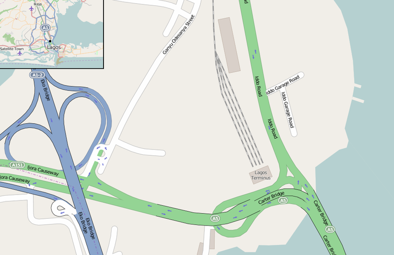
and the surrounding area. In the upper corner is shown (black dot) the station within Lagos
Metropolitan Area
517:
512:
254:– If you remix, transform, or build upon the material, you must distribute your contributions under the
56:
37:
396:"}},"text\/plain":{"en":{"P6216":"copyrighted"}}}}": -->
545:
The following pages on the
English Knowledge use this file (pages on other projects are not listed):
105:
330:
derivative work (the addition of a map in the corner with the black dot indicating the station)
214:
136:
This map may be incomplete, and may contain errors. Don't rely solely on it for navigation.
8:
318:
322:
188:
92:
368:
289:
131:
567:
587:
528:
457:
413:
159:
485:
Click on a date/time to view the file as it appeared at that time.
319:
OSM map page of Lagos
Terminus station and surrounding area
80:
362:
Add a one-line explanation of what this file represents
298:
If inappropriate please set warp_status = skip to hide.
577:
543:
558:
483:
104:
Commons is a freely licensed media file repository.
464:
Creative
Commons Attribution-ShareAlike 2.0 Generic
438:
Creative
Commons Attribution-ShareAlike 2.0 Generic
284:
191:Attribution-ShareAlike 2.0 license (CC-BY-SA 2.0).
187:OpenStreetMap data and maps are licensed under the
70:(940 × 610 pixels, file size: 120 KB, MIME type:
265:https://creativecommons.org/licenses/by-sa/2.0
85:
271:Creative Commons Attribution-Share Alike 2.0
195:
175:
142:
122:
339:Map showing the Nigerian railway station of
165:
150:
14:
231:– to copy, distribute and transmit the work
134:project data, collected by the community.
119:
560:The following other wikis use this file:
323:source for the image in the upper corner
292:Georeference the map in Wikimaps Warper
116:
476:
218:Attribution-Share Alike 2.0 Generic
206:
201:
13:
367:
361:
333:
192:
125:Lagos Terminus (OpenStreetMap).png
117:
63:
601:
366:
160:OpenStreetMap wiki page for Lagos
544:
352:
242:Under the following conditions:
213:This file is licensed under the
205:
200:
194:
84:
31:
21:
349:
334:
588:Lagos Terminus railway station
555:
550:Lagos Terminus railway station
480:
348:
26:
1:
290:
540:
374:Items portrayed in this file
7:
568:Tashar jirgin ƙasa ta Lagos
130:This map was created from
10:
606:
584:Usage on yo.wikipedia.org
574:Usage on www.wikidata.org
564:Usage on ha.wikipedia.org
309:
256:same or compatible license
170:OpenStreetMap contributors
477:
16:
513:15:42, 19 September 2015
351:
222:
91:This is a file from the
36:
534:
95:. Information from its
98:description page there
41:Size of this preview:
237:– to adapt the work
158:find a page on the
47:Other resolutions:
146:(see file history)
556:Global file usage
538:
448:copyright license
434:copyright license
360:
303:
302:
299:
184:
181:Reusing this file
137:
113:
112:
93:Wikimedia Commons
32:Global file usage
597:
525:
487:
404:copyright status
390:copyright status
358:
338:
297:
296:
294:
293:
278:
275:
272:
269:
266:
258:as the original.
215:Creative Commons
209:
208:
204:
203:
198:
197:
189:Creative Commons
178:
135:
126:
120:
109:
88:
87:
81:
75:
73:
60:
57:940 × 610 pixels
53:640 × 415 pixels
49:320 × 208 pixels
43:800 × 519 pixels
605:
604:
600:
599:
598:
596:
595:
594:
554:
546:
539:
531:
523:
479:
478:
475:
474:
473:
472:
471:
470:
469:
468:
466:
454:
453:
452:
450:
431:
430:
429:
428:
427:
426:
425:
424:
422:
410:
409:
408:
406:
387:
386:
385:
384:
383:
381:
365:
364:
363:
344:
312:
304:
291:
288:
280:
279:
276:
273:
270:
267:
264:
263:
221:
210:
171:
138:
124:
115:
114:
103:
102:
101:is shown below.
77:
71:
69:
62:
61:
46:
12:
11:
5:
603:
593:
592:
591:
590:
582:
581:
580:
572:
571:
570:
557:
553:
552:
542:
537:
536:
533:
529:
526:
520:
515:
510:
506:
505:
502:
499:
496:
493:
490:
482:
467:
462:
460:
459:
458:
456:
455:
451:
446:
444:
443:
442:
441:
439:
435:
423:
418:
416:
415:
414:
412:
411:
407:
402:
400:
399:
398:
397:
395:
391:
382:
377:
375:
372:
371:
370:
369:
357:
356:
353:
350:
346:
345:
341:Lagos Terminus
331:
325:
311:
308:
301:
300:
286:
285:Georeferencing
282:
281:
262:
261:
260:
259:
249:
240:
239:
238:
232:
225:You are free:
212:
211:
193:
185:
173:
172:
169:
167:
163:
162:
152:
148:
147:
144:
140:
139:
129:
127:
118:
111:
110:
89:
79:
78:
40:
35:
34:
29:
24:
19:
9:
6:
4:
3:
2:
602:
589:
586:
585:
583:
579:
576:
575:
573:
569:
566:
565:
563:
562:
561:
551:
548:
547:
532:
527:
521:
519:
516:
514:
511:
508:
507:
503:
500:
497:
494:
491:
489:
488:
486:
465:
461:
449:
445:
421:
417:
405:
401:
380:
376:
373:
354:
347:
342:
337:
332:
329:
326:
324:
320:
317:
314:
313:
307:
306:
295:
287:
283:
268:CC BY-SA 2.0
257:
253:
250:
247:
244:
243:
241:
236:
233:
230:
227:
226:
224:
223:
219:
216:
199:
190:
186:
182:
177:
174:
168:
164:
161:
157:
153:
149:
145:
141:
133:
132:OpenStreetMap
128:
121:
107:
100:
99:
94:
90:
83:
82:
76:
67:
66:Original file
58:
54:
50:
44:
39:
33:
30:
28:
25:
23:
20:
18:
15:
559:
484:
481:File history
335:
327:
316:Source link:
315:
305:
251:
245:
234:
228:
155:
106:You can help
96:
64:
22:File history
420:copyrighted
394:copyrighted
252:share alike
246:attribution
123:Description
541:File usage
522:940 × 610
498:Dimensions
176:Permission
27:File usage
578:Q20984849
495:Thumbnail
492:Date/Time
336:English:
72:image/png
524:(120 KB)
355:Captions
235:to remix
229:to share
220:license.
530:DerBorg
509:current
504:Comment
379:depicts
359:English
321:. Plus
310:Summary
166:Creator
68:
151:Source
328:Note:
501:User
277:true
274:true
154:You
143:Date
17:File
156:may
55:|
51:|
45:.
183:)
179:(
108:.
74:)
59:.

.png)