127:
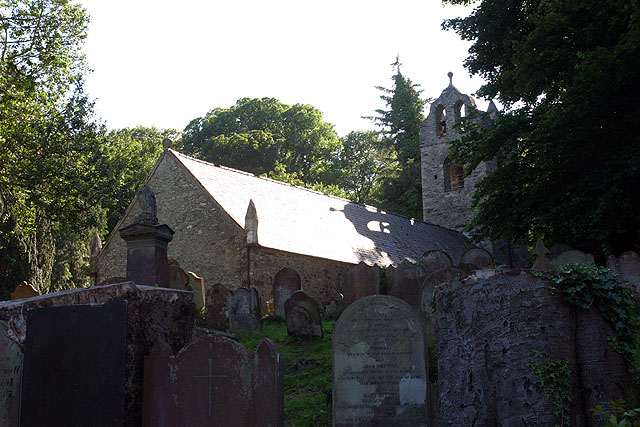
walls. Built 1773 following presentations that the roof and gable of the previous church were unsafe and also after complaints that the previous church was too small. The received wisdom is that the old church was demolished and the new built from the reclaimed rubble though with quoins of
Foxdale granite. However recent surveys by Mr F. Cowin have convinced him that although the east end was demolished and rebuilt and the tower added, the remaining walls are mostly the original dating from the twelfth century. Following the precedent of St Marks (b 1772) the four corners were marked by pinnacles. Unlike many other island churches it was probably never whitewashed.
779:"}},"text\/plain":{"en":{"":"coordinates of depicted place"}}},"{\"value\":{\"latitude\":54.158,\"longitude\":-4.51,\"altitude\":null,\"precision\":0.001,\"globe\":\"http:\\\/\\\/www.wikidata.org\\\/entity\\\/Q2\"},\"type\":\"globecoordinate\"}":{"text\/html":{"en":{"P9149":"54\u00b09'29"N, 4\u00b030'36"W"}},"text\/plain":{"en":{"P9149":"54\u00b09'29\"N, 4\u00b030'36\"W"}}}}": -->
439:"}},"text\/plain":{"en":{"":"author name string"}}},"{\"value\":\"Andy Stephenson\",\"type\":\"string\"}":{"text\/html":{"en":{"P2093":"Andy Stephenson"}},"text\/plain":{"en":{"P2093":"Andy Stephenson"}}},"{\"value\":{\"entity-type\":\"property\",\"numeric-id\":2699,\"id\":\"P2699\"},\"type\":\"wikibase-entityid\"}":{"text\/html":{"en":{"":"
741:"}},"text\/plain":{"en":{"":"inception"}}},"{\"value\":{\"time\":\"+2005-07-06T00:00:00Z\",\"timezone\":0,\"before\":0,\"after\":0,\"precision\":11,\"calendarmodel\":\"http:\\\/\\\/www.wikidata.org\\\/entity\\\/Q1985727\"},\"type\":\"time\"}":{"text\/html":{"en":{"P571":"6 July 2005"}},"text\/plain":{"en":{"P571":"6 July 2005"}}}}": -->
618:
423:
238:
259:
297:
302:
72:
626:"}},"text\/plain":{"en":{"P7482":"file available on the internet"}}},"{\"value\":{\"entity-type\":\"property\",\"numeric-id\":7384,\"id\":\"P7384\"},\"type\":\"wikibase-entityid\"}":{"text\/html":{"en":{"":"
431:"}},"text\/plain":{"en":{"":"object of statement has role"}}},"{\"value\":{\"entity-type\":\"item\",\"numeric-id\":33231,\"id\":\"Q33231\"},\"type\":\"wikibase-entityid\"}":{"text\/html":{"en":{"P3831":"
642:"}},"text\/plain":{"en":{"P137":"Geograph Britain and Ireland"}}},"{\"value\":{\"entity-type\":\"property\",\"numeric-id\":973,\"id\":\"P973\"},\"type\":\"wikibase-entityid\"}":{"text\/html":{"en":{"":"
817:"}},"text\/plain":{"en":{"":"media type"}}},"{\"value\":\"image\\\/jpeg\",\"type\":\"string\"}":{"text\/html":{"en":{"P1163":"image\/jpeg"}},"text\/plain":{"en":{"P1163":"image\/jpeg"}}}}": -->
578:"}},"text\/plain":{"en":{"":"copyright license"}}},"{\"value\":{\"entity-type\":\"item\",\"numeric-id\":19068220,\"id\":\"Q19068220\"},\"type\":\"wikibase-entityid\"}":{"text\/html":{"en":{"P275":"
534:"}},"text\/plain":{"en":{"":"copyright status"}}},"{\"value\":{\"entity-type\":\"item\",\"numeric-id\":50423863,\"id\":\"Q50423863\"},\"type\":\"wikibase-entityid\"}":{"text\/html":{"en":{"P6216":"
622:"}},"text\/plain":{"en":{"":"source of file"}}},"{\"value\":{\"entity-type\":\"item\",\"numeric-id\":74228490,\"id\":\"Q74228490\"},\"type\":\"wikibase-entityid\"}":{"text\/html":{"en":{"P7482":"
435:"}},"text\/plain":{"en":{"P3831":"photographer"}}},"{\"value\":{\"entity-type\":\"property\",\"numeric-id\":2093,\"id\":\"P2093\"},\"type\":\"wikibase-entityid\"}":{"text\/html":{"en":{"":"
638:"}},"text\/plain":{"en":{"":"operator"}}},"{\"value\":{\"entity-type\":\"item\",\"numeric-id\":1503119,\"id\":\"Q1503119\"},\"type\":\"wikibase-entityid\"}":{"text\/html":{"en":{"P137":"
893:
634:"}},"text\/plain":{"en":{"P7384":"24358"}}},"{\"value\":{\"entity-type\":\"property\",\"numeric-id\":137,\"id\":\"P137\"},\"type\":\"wikibase-entityid\"}":{"text\/html":{"en":{"":"
427:"}},"text\/plain":{"en":{"":"creator"}}},"{\"value\":{\"entity-type\":\"property\",\"numeric-id\":3831,\"id\":\"P3831\"},\"type\":\"wikibase-entityid\"}":{"text\/html":{"en":{"":"
813:
630:"}},"text\/plain":{"en":{"":"geograph.org.uk image ID"}}},"{\"value\":\"24358\",\"type\":\"string\"}":{"text\/html":{"en":{"P7384":"
910:== {{int:filedesc}} == {{Information |description={{en|1=Kirk Braddan Old Church. The mother church of Douglas set in a beautiful wooded valley by the River Dhoo. The churchyard is full of Georgian head-stones and dominated by an obelisk designed by Steua
215:
349:– You must give appropriate credit, provide a link to the license, and indicate if changes were made. You may do so in any reasonable manner, but not in any way that suggests the licensor endorses you or your use.
221:
83:
51:
1002:
929:
623:
579:
535:
631:
639:
432:
814:
776:
627:
619:
531:
440:
436:
428:
738:
643:
635:
575:
424:
647:
444:
903:
582:"}},"text\/plain":{"en":{"P275":"Creative Commons Attribution-ShareAlike 2.0 Generic"}}}}": -->
650:"}},"text\/plain":{"en":{"P973":"https:\/\/www.geograph.org.uk\/photo\/24358"}}}}": -->
447:"}},"text\/plain":{"en":{"P2699":"https:\/\/www.geograph.org.uk\/profile\/11"}}}}": -->
673:
605:
561:
231:
708:
266:
1040:
This file contains additional information, probably added from the digital camera or scanner used to create or digitize it.
356:
488:
924:
824:
786:
686:
657:
545:
509:
496:
481:
892:
887:
42:
748:
716:
701:
589:
454:
413:
312:
1043:
If the file has been modified from its original state, some details may not fully reflect the modified file.
934:
355:– If you remix, transform, or build upon the material, you must distribute your contributions under the
273:
on the
Geograph website for the photographer's contact details. The copyright on this image is owned by
538:"}},"text\/plain":{"en":{"P6216":"copyrighted"}}}}": -->
920:
The following pages on the
English Knowledge use this file (pages on other projects are not listed):
91:
184:
309:
168:
723:
693:
8:
516:
253:
237:
278:
78:
1017:
403:
952:
972:
147:
834:
796:
758:
667:
599:
555:
464:
258:
157:
270:
860:
Click on a date/time to view the file as it appeared at that time.
223:
1012:
930:
Registered
Buildings and Conservation Areas of the Isle of Man
962:
982:
136:
66:
397:
Add a one-line explanation of what this file represents
1027:
918:
116:
Kirk
Braddan Old Church - geograph.org.uk - 24358.jpg
52:
Kirk_Braddan_Old_Church_-_geograph.org.uk_-_24358.jpg
943:
858:
90:
Commons is a freely licensed media file repository.
606:
Creative
Commons Attribution-ShareAlike 2.0 Generic
580:
Creative
Commons Attribution-ShareAlike 2.0 Generic
992:
56:(640 × 427 pixels, file size: 92 KB, MIME type:
366:https://creativecommons.org/licenses/by-sa/2.0
71:
372:Creative Commons Attribution-Share Alike 2.0
290:
132:
113:
153:
142:
14:
648:https:\/\/www.geograph.org.uk\/photo\/24358
332:– to copy, distribute and transmit the work
445:https:\/\/www.geograph.org.uk\/profile\/11
945:The following other wikis use this file:
724:https://www.geograph.org.uk/photo/24358
216:54° 09′ N, 4° 31′ W
1003:Участник:Ivan A. Krestinin/Иллюстрации
517:https://www.geograph.org.uk/profile/11
230:View this and other nearby images on:
191:
102:
277:and is licensed for reuse under the
206:
925:List of parishes of the Isle of Man
851:
313:Attribution-Share Alike 2.0 Generic
301:
296:
281:Attribution-ShareAlike 2.0 license.
13:
1038:
402:
396:
287:
264:
120:
103:
49:
1064:
1045:
973:Braddan (paroisse administrative)
401:
919:
387:
343:Under the following conditions:
308:This file is licensed under the
300:
295:
289:
257:
236:
222:
70:
31:
21:
384:
121:
46:No higher resolution available.
940:
855:
674:file available on the internet
624:file available on the internet
383:
265:This image was taken from the
26:
1:
1018:Administratívne členenie Manu
787:coordinates of depicted place
777:coordinates of depicted place
36:
915:
709:Geograph Britain and Ireland
640:Geograph Britain and Ireland
482:object of statement has role
429:object of statement has role
409:Items portrayed in this file
249:
197:Andy Stephenson /
178:Andy Stephenson /
7:
1035:
949:Usage on arz.wikipedia.org
935:Union Mills railway station
10:
1069:
1024:Usage on www.wikidata.org
1009:Usage on sk.wikipedia.org
999:Usage on ru.wikipedia.org
989:Usage on nl.wikipedia.org
979:Usage on gv.wikipedia.org
969:Usage on fr.wikipedia.org
959:Usage on de.wikipedia.org
357:same or compatible license
110:
105:
852:
16:
687:geograph.org.uk image ID
628:geograph.org.uk image ID
386:
323:
77:This is a file from the
41:
909:
199:Kirk Braddan Old Church
180:Kirk Braddan Old Church
169:required by the license
135:
81:. Information from its
888:03:32, 30 January 2010
271:this photograph's page
242:54.158000; -4.510000
84:description page there
802:54°9'29"N, 4°30'36"W
338:– to adapt the work
497:author name string
437:author name string
1056:
1055:
941:Global file usage
913:
590:copyright license
576:copyright license
395:
286:
285:
269:collection. See
247:
246:
204:
203:
172:
99:
98:
79:Wikimedia Commons
32:Global file usage
1060:
1046:
963:Old Kirk Braddan
900:
862:
726:
721:
717:described at URL
711:
706:
696:
691:
644:described at URL
546:copyright status
532:copyright status
519:
514:
504:
501:
491:
486:
393:
379:
376:
373:
370:
367:
359:as the original.
321:
310:Creative Commons
304:
303:
299:
298:
293:
292:
279:Creative Commons
267:Geograph project
261:
254:
243:
240:
226:
225:
219:
218:
207:
166:
138:
125:
117:
111:
95:
74:
73:
67:
61:
59:
1068:
1067:
1063:
1062:
1061:
1059:
1058:
1057:
1034:
983:Skeerey Vraddan
939:
921:
914:
906:
898:
854:
853:
850:
849:
848:
847:
846:
845:
844:
843:
841:
831:
830:
829:
827:
812:
811:
810:
809:
808:
807:
806:
805:
803:
793:
792:
791:
789:
774:
773:
772:
771:
770:
769:
768:
767:
765:
755:
754:
753:
751:
736:
735:
734:
733:
732:
731:
730:
729:
728:
727:
722:
719:
713:
712:
707:
704:
698:
697:
692:
689:
680:
679:
678:
676:
664:
663:
662:
660:
617:
616:
615:
614:
613:
612:
611:
610:
608:
596:
595:
594:
592:
573:
572:
571:
570:
569:
568:
567:
566:
564:
552:
551:
550:
548:
529:
528:
527:
526:
525:
524:
523:
522:
521:
520:
515:
512:
506:
505:
503:Andy Stephenson
502:
499:
493:
492:
487:
484:
475:
474:
473:
471:
461:
460:
459:
457:
422:
421:
420:
419:
418:
416:
400:
399:
398:
381:
380:
377:
374:
371:
368:
365:
364:
322:
320:Andy Stephenson
319:
316:
305:
282:
275:Andy Stephenson
252:
241:
214:
213:
210:Object location
205:
194:
187:
175:
158:Andy Stephenson
148:geograph.org.uk
128:
115:
108:
101:
100:
89:
88:
87:is shown below.
63:
57:
55:
48:
47:
12:
11:
5:
1066:
1054:
1053:
1050:
1037:
1033:
1032:
1031:
1030:
1022:
1021:
1020:
1015:
1007:
1006:
1005:
997:
996:
995:
987:
986:
985:
977:
976:
975:
967:
966:
965:
957:
956:
955:
942:
938:
937:
932:
927:
917:
912:
911:
908:
904:
901:
895:
890:
885:
881:
880:
877:
874:
871:
868:
865:
857:
842:
839:
837:
836:
835:
833:
832:
828:
823:
821:
820:
819:
818:
816:
804:
801:
799:
798:
797:
795:
794:
790:
785:
783:
782:
781:
780:
778:
766:
763:
761:
760:
759:
757:
756:
752:
747:
745:
744:
743:
742:
740:
715:
714:
700:
699:
685:
684:
683:
682:
681:
677:
672:
670:
669:
668:
666:
665:
661:
658:source of file
656:
654:
653:
652:
651:
649:
645:
641:
637:
633:
629:
625:
621:
620:source of file
609:
604:
602:
601:
600:
598:
597:
593:
588:
586:
585:
584:
583:
581:
577:
565:
560:
558:
557:
556:
554:
553:
549:
544:
542:
541:
540:
539:
537:
533:
508:
507:
495:
494:
480:
479:
478:
477:
476:
472:
469:
467:
466:
465:
463:
462:
458:
453:
451:
450:
449:
448:
446:
442:
438:
434:
430:
426:
417:
412:
410:
407:
406:
405:
404:
392:
391:
388:
385:
363:
362:
361:
360:
350:
341:
340:
339:
333:
326:You are free:
317:
307:
306:
288:
284:
283:
262:
251:
248:
245:
244:
234:
228:
211:
202:
201:
195:
192:
189:
188:
183:
176:
173:
161:
160:
155:
151:
150:
144:
140:
139:
134:
130:
129:
118:
109:
107:
104:
97:
96:
75:
65:
64:
45:
40:
39:
34:
29:
24:
19:
9:
6:
4:
3:
2:
1065:
1051:
1048:
1047:
1044:
1041:
1029:
1026:
1025:
1023:
1019:
1016:
1014:
1013:Farnosť (Man)
1011:
1010:
1008:
1004:
1001:
1000:
998:
994:
991:
990:
988:
984:
981:
980:
978:
974:
971:
970:
968:
964:
961:
960:
958:
954:
951:
950:
948:
947:
946:
936:
933:
931:
928:
926:
923:
922:
907:
902:
896:
894:
891:
889:
886:
883:
882:
878:
875:
872:
869:
866:
864:
863:
861:
838:
826:
822:
800:
788:
784:
762:
750:
746:
725:
718:
710:
703:
695:
688:
675:
671:
659:
655:
607:
603:
591:
587:
563:
559:
547:
543:
518:
511:
498:
490:
483:
468:
456:
452:
415:
411:
408:
389:
382:
369:CC BY-SA 2.0
358:
354:
351:
348:
345:
344:
342:
337:
334:
331:
328:
327:
325:
324:
318:Attribution:
314:
311:
294:
280:
276:
272:
268:
263:
260:
256:
255:
239:
235:
233:
232:OpenStreetMap
229:
227:
217:
212:
209:
208:
200:
196:
190:
186:
182: /
181:
177:
170:
165:
163:
162:
159:
156:
152:
149:
145:
141:
131:
124:
119:
112:
93:
86:
85:
80:
76:
69:
68:
62:
53:
44:
38:
35:
33:
30:
28:
25:
23:
20:
18:
15:
1042:
1039:
944:
859:
856:File history
489:photographer
433:photographer
352:
346:
335:
329:
274:
198:
185:CC BY-SA 2.0
179:
122:
92:You can help
82:
50:
22:File history
905:GeographBot
764:6 July 2005
562:copyrighted
536:copyrighted
353:share alike
347:attribution
164:Attribution
137:6 July 2005
114:Description
1049:_error
916:File usage
897:640 × 427
873:Dimensions
840:image/jpeg
825:media type
815:media type
470:some value
58:image/jpeg
27:File usage
870:Thumbnail
867:Date/Time
749:inception
739:inception
250:Licensing
193:InfoField
174:InfoField
123:English:
1036:Metadata
1028:Q2018409
702:operator
636:operator
390:Captions
336:to remix
330:to share
315:license.
37:Metadata
953:نهر دهو
899:(92 KB)
884:current
879:Comment
455:creator
425:creator
414:depicts
394:English
106:Summary
54:
220:
154:Author
143:Source
694:24358
632:24358
146:From
993:Dhoo
876:User
378:true
375:true
133:Date
17:File
510:URL
441:URL
720::
705::
690::
513::
500::
485::
1052:0
171:)
167:(
94:.
60:)
_&language=en)
