246:
38:
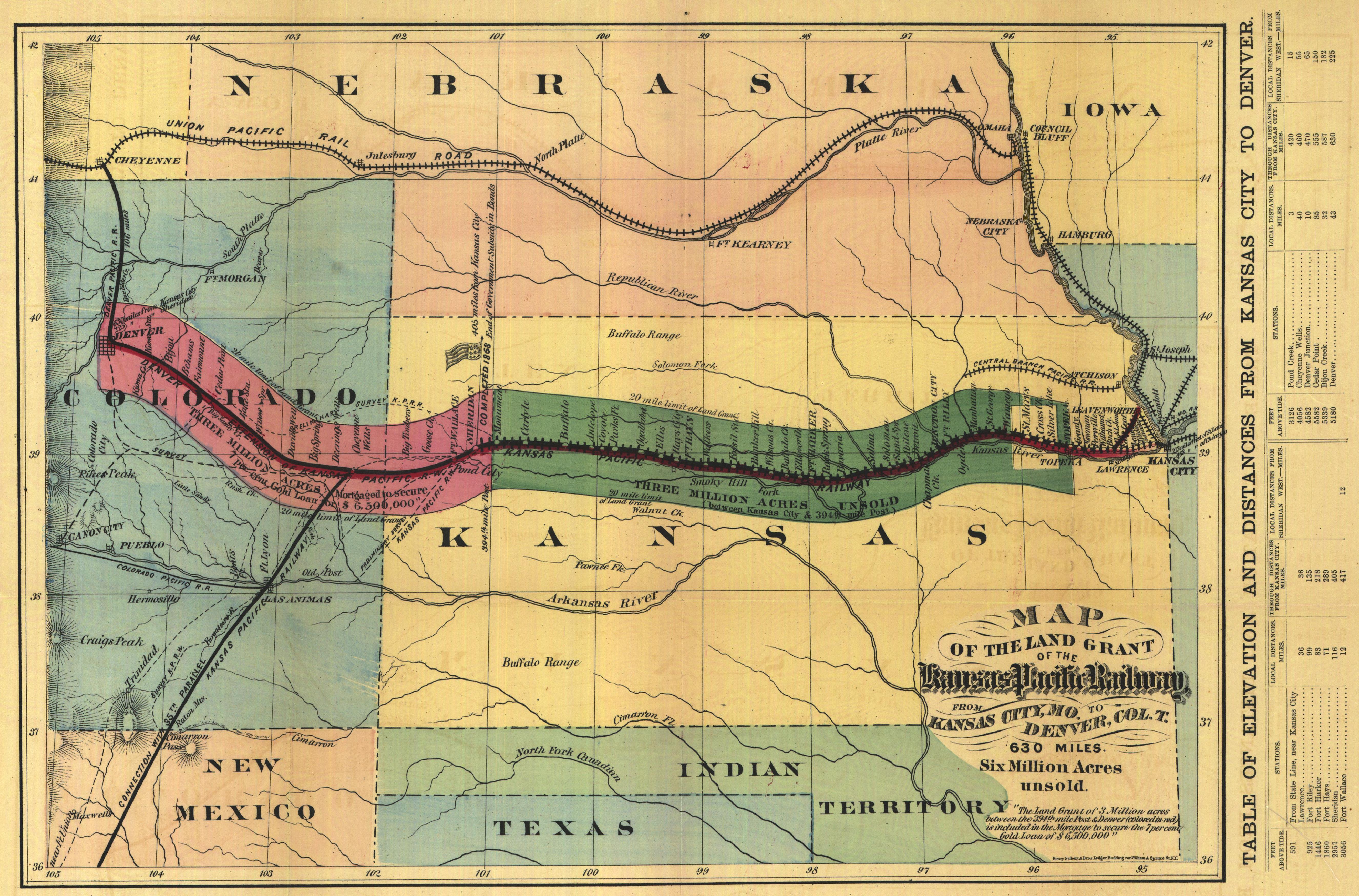
163:. It was made in 1869 by Henry Seibert & Bros. The original map is 28 x 40 cm. In addition to the rail line, the map shows Native American habitation and bison ranges. The line between Kansas City (east) and Denver (west) is separated into the two sections (the western extension to Colorado was built in 1879, several years after the eastern section). The coloration indicates the extent of the land grants on either side of the rail line.
258:
210:
98:
360:
330:
272:
for US works, such as Canada, Mainland China (not Hong Kong or Macao), Germany, Mexico, and
Switzerland. The creator and year of publication are essential information and must be provided. See
370:
268:
This image might not be in the public domain outside of the United States; this especially applies in the countries and areas that do not apply the
401:
153:
64:
60:
56:
426:
52:
48:
42:
109:
77:
509:
359:
354:
177:
269:
387:
The following pages on the
English Knowledge use this file (pages on other projects are not listed):
273:
139:
117:
416:
396:
277:
235:
161:
Map of the Land Grant of the Kansas
Pacific Railway, from Kansas City, Mo. to Denver Col. T.
489:
8:
406:
329:
324:
234:
occurred prior to
January 1, 1929, and if not then due to lack of notice or renewal. See
68:
37:
230:. This applies to U.S. works where the copyright has expired, often because its first
391:
104:
411:
227:
222:
421:
231:
340:
454:
377:
Historic map of the Kansas
Pacific Railway lines in the western U.S.
519:
499:
484:
474:
464:
449:
297:
Click on a date/time to view the file as it appeared at that time.
529:
92:
82:(5,304 × 3,497 pixels, file size: 2.71 MB, MIME type:
539:
385:
435:
295:
178:
Digitized Kansas maps from the
University of Wichita
116:
Commons is a freely licensed media file repository.
444:
97:
14:
437:The following other wikis use this file:
402:Railroad land grants in the United States
427:Portal:Trains/Anniversaries/August 15
245:
209:
128:
204:
490:Histoire de la culture des céréales
13:
267:
256:
244:
218:
208:
129:
75:
553:
386:
96:
31:
21:
154:First Transcontinental Railroad
526:Usage on simple.wikipedia.org
432:
292:
26:
1:
137:Historic map of the proposed
382:
7:
10:
558:
536:Usage on www.wikidata.org
516:Usage on no.wikipedia.org
506:Usage on ja.wikipedia.org
496:Usage on hu.wikipedia.org
481:Usage on fr.wikipedia.org
471:Usage on fi.wikipedia.org
461:Usage on es.wikipedia.org
455:Benutzer:Liesel/In Arbeit2
441:Usage on de.wikipedia.org
220:This media file is in the
131:
143:lines in the Western U.S.
16:
270:rule of the shorter term
238:for further explanation.
103:This is a file from the
36:
376:
346:
274:Knowledge:Public domain
152:Proposed route for the
107:. Information from its
520:Kansas Pacific Railway
500:Kansas Pacific Railway
485:Kansas Pacific Railway
475:Kansas Pacific Railway
465:William Jackson Palmer
450:Kansas Pacific Railway
417:William Jackson Palmer
397:Kansas Pacific Railway
261:
250:
214:
140:Kansas Pacific Railway
110:description page there
41:Size of this preview:
372:Decumanus~commonswiki
260:
248:
212:
355:08:55, 13 March 2005
278:Knowledge:Copyrights
159:The map is entitled
69:5,304 × 3,497 pixels
65:2,560 × 1,688 pixels
407:Sand Creek massacre
325:15:51, 22 July 2013
47:Other resolutions:
262:
251:
215:
61:1,280 × 844 pixels
57:1,024 × 675 pixels
530:History of Kansas
433:Global file usage
392:History of Kansas
380:
289:
288:
282:
280:for more details.
203:
202:
125:
124:
105:Wikimedia Commons
32:Global file usage
549:
412:Sheridan, Kansas
367:
337:
299:
283:
266:
259:
247:
211:
205:
199:
196:
193:
190:
185:
184:
121:
100:
99:
93:
87:
85:
72:
53:640 × 422 pixels
49:320 × 211 pixels
43:800 × 527 pixels
557:
556:
552:
551:
550:
548:
547:
546:
431:
388:
381:
373:
365:
347:greater version
343:
335:
291:
290:
281:
265:
257:
240:
197:
194:
191:
188:
134:
127:
126:
115:
114:
113:is shown below.
89:
83:
81:
74:
73:
46:
12:
11:
5:
555:
545:
544:
543:
542:
534:
533:
532:
524:
523:
522:
514:
513:
512:
504:
503:
502:
494:
493:
492:
487:
479:
478:
477:
469:
468:
467:
459:
458:
457:
452:
447:
434:
430:
429:
424:
419:
414:
409:
404:
399:
394:
384:
379:
378:
375:
371:
368:
362:
357:
352:
349:
348:
345:
341:
338:
334:5,304 × 3,497
332:
327:
322:
318:
317:
314:
311:
308:
305:
302:
294:
287:
286:
284:
263:
253:
252:
242:
216:
201:
200:
174:
173:
169:
168:
167:
166:
165:
164:
157:
145:
144:
133:
130:
123:
122:
101:
91:
90:
40:
35:
34:
29:
24:
19:
9:
6:
4:
3:
2:
554:
541:
538:
537:
535:
531:
528:
527:
525:
521:
518:
517:
515:
511:
508:
507:
505:
501:
498:
497:
495:
491:
488:
486:
483:
482:
480:
476:
473:
472:
470:
466:
463:
462:
460:
456:
453:
451:
448:
446:
443:
442:
440:
439:
438:
428:
425:
423:
422:Portal:Kansas
420:
418:
415:
413:
410:
408:
405:
403:
400:
398:
395:
393:
390:
389:
374:
369:
363:
361:
358:
356:
353:
351:
350:
344:
339:
333:
331:
328:
326:
323:
320:
319:
315:
312:
309:
306:
303:
301:
300:
298:
285:
279:
275:
271:
264:
255:
254:
249:United States
243:
241:
239:
237:
233:
229:
228:United States
225:
224:
223:public domain
217:
213:Public domain
207:
206:
192:Public domain
189:Public domain
187:
186:
183:
182:
180:
179:
171:
170:
162:
158:
155:
151:
150:
149:
148:
147:
146:
142:
141:
136:
135:
119:
112:
111:
106:
102:
95:
94:
88:
79:
78:Original file
70:
66:
62:
58:
54:
50:
44:
39:
33:
30:
28:
25:
23:
20:
18:
15:
436:
296:
293:File history
221:
219:
181:
175:
160:
138:
118:You can help
108:
76:
22:File history
232:publication
383:File usage
364:640 × 438
310:Dimensions
84:image/jpeg
27:File usage
336:(2.71 MB)
307:Thumbnail
304:Date/Time
236:this page
540:Q3192731
510:カンザス州の歴史
176:source:
366:(70 KB)
321:current
316:Comment
226:in the
172:Credits
132:Summary
80:
445:Kansas
342:Liesel
198:false
195:false
313:User
276:and
17:File
67:|
63:|
59:|
55:|
51:|
45:.
156:.
120:.
86:)
71:.
Text is available under the Creative Commons Attribution-ShareAlike License. Additional terms may apply.