418:
315:
270:
321:
438:
326:
43:
91:
780:"}},"text\/plain":{"en":{"P275":"GNU Free Documentation License, version 1.2 or later"}}},"{\"value\":{\"entity-type\":\"item\",\"numeric-id\":14946043,\"id\":\"Q14946043\"},\"type\":\"wikibase-entityid\"}":{"text\/html":{"en":{"P275":"
776:"}},"text\/plain":{"en":{"":"copyright license"}}},"{\"value\":{\"entity-type\":\"item\",\"numeric-id\":50829104,\"id\":\"Q50829104\"},\"type\":\"wikibase-entityid\"}":{"text\/html":{"en":{"P275":"
732:"}},"text\/plain":{"en":{"":"copyright status"}}},"{\"value\":{\"entity-type\":\"item\",\"numeric-id\":50423863,\"id\":\"Q50423863\"},\"type\":\"wikibase-entityid\"}":{"text\/html":{"en":{"P6216":"
969:
939:
909:
728:
1196:
1186:
367:– You must give appropriate credit, provide a link to the license, and indicate if changes were made. You may do so in any reasonable manner, but not in any way that suggests the licensor endorses you or your use.
1440:
781:
777:
733:
729:
773:
57:
53:
47:
102:
70:
287:
1123:
1133:
784:"}},"text\/plain":{"en":{"P275":"Creative Commons Attribution-ShareAlike 3.0 Unported"}}}}": -->
452:
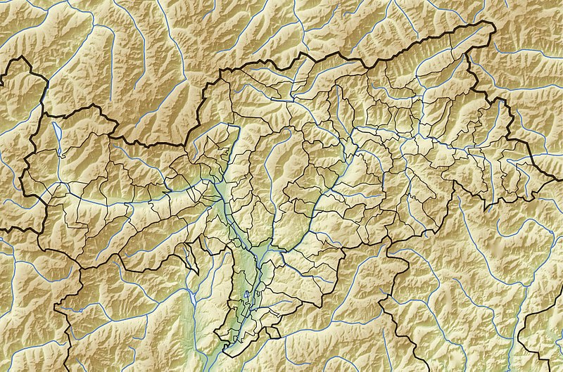
994:}} Quadratische Plattkarte, N-S-Streckung 150 %. Geographische Begrenzung der Karte: * N: 47.15° N * S: 46.18° N * W: 10.3° O * O: 12.5°
1128:
285:; with no Invariant Sections, no Front-Cover Texts, and no Back-Cover Texts. A copy of the license is included in the section entitled
251:
968:
963:
938:
933:
908:
903:
1013:
1008:
824:
807:
759:
1451:
This file contains additional information, probably added from the digital camera or scanner used to create or digitize it.
1033:
1028:
417:
374:
743:
1023:
277:
791:
718:
1018:
336:
1216:
878:
873:
677:
61:
42:
1454:
If the file has been modified from its original state, some details may not fully reflect the modified file.
1487:
445:
282:
373:– If you remix, transform, or build upon the material, you must distribute your contributions under the
178:
736:"}},"text\/plain":{"en":{"P6216":"copyrighted"}}}}": -->
1161:
1004:
The following pages on the
English Knowledge use this file (pages on other projects are not listed):
1093:
110:
275:
Permission is granted to copy, distribute and/or modify this document under the terms of the
1053:
333:
1151:
8:
1176:
437:
236:
155:
Quadratische
Plattkarte, N-S-Streckung 150 %. Geographische Begrenzung der Karte:
1206:
979:
949:
919:
889:
261:
I, the copyright holder of this work, hereby publish it under the following licenses:
187:
Equirectangular projection, N/S stretching 150 %. Geographic limits of the map:
97:
708:
487:
1386:
1118:
1098:
1083:
1078:
1038:
1416:
1326:
987:
595:
559:
146:
1113:
1088:
667:
658:
649:
640:
631:
622:
613:
604:
586:
577:
568:
550:
541:
532:
523:
514:
505:
496:
478:
469:
460:
1068:
240:
1043:
1502:
818:
801:
753:
1311:
1103:
991:
150:
1331:
1108:
1063:
1058:
264:
1341:
1073:
846:
Click on a date/time to view the file as it appeared at that time.
1376:
1316:
1256:
1336:
1246:
1048:
1366:
182:
1281:
1296:
986:{{Information |Description= {{de|Physische Positionskarte von
1431:
1361:
1351:
1306:
1381:
1271:
1241:
1411:
1401:
1266:
85:
1396:
1371:
1321:
1426:
1406:
1286:
1261:
1221:
702:
Add a one-line explanation of what this file represents
1421:
1391:
1276:
1251:
1236:
223:
United States
National Imagery and Mapping Agency data
1356:
1346:
1301:
1291:
1171:
1002:
1231:
1142:
844:
825:
Creative
Commons Attribution-ShareAlike 3.0 Unported
808:
782:
Creative
Commons Attribution-ShareAlike 3.0 Unported
778:
281:, Version 1.2 or any later version published by the
109:
Commons is a freely licensed media file repository.
75:(1,037 × 686 pixels, file size: 380 KB, MIME type:
1124:User:Michael!/Project:Location map templates/Italy
444:This map has been made or improved in the German
1217:Šablona:LocMap Itálie Autonomní provincie Bolzano
1134:Module:Location map/data/Italy South Tyrol/doc
384:https://creativecommons.org/licenses/by-sa/3.0
90:
390:Creative Commons Attribution-Share Alike 3.0
314:
246:
206:
132:
1197:টেমপ্লেট:অবস্থান মানচিত্র South Tyrol relief
409:
232:
214:
14:
350:– to copy, distribute and transmit the work
135:Italy Bolzano-Bozen relief location map.jpg
1129:Module:Location map/data/Italy South Tyrol
402:You may select the license of your choice.
1144:The following other wikis use this file:
1207:Plantilya:Location map Italy South Tyrol
1152:Vorlage:Positionskarte Italien Südtirol
1034:Alpini Battalion "Val Chiese"
1029:Alpini Battalion "Val Brenta"
1014:5th Mountain Artillery Regiment (Italy)
1009:2nd Mountain Artillery Regiment (Italy)
1177:Vorlog:Positionskarte Italien Südtirol
1024:Alpine Brigade "Tridentina"
121:
337:Attribution-Share Alike 3.0 Unported
293:http://www.gnu.org/copyleft/fdl.html
1187:Ҡалып:ПозКарта Италия Көньяҡ Тироль
1162:قالب:Location map Italy South Tyrol
837:
325:
320:
13:
1449:
1019:Alpine Brigade "Orobica"
707:
701:
443:
401:
311:
260:
171:
139:
122:
68:
1519:
1456:
1417:Burg Hauenstein (Seis am Schlern)
706:
1003:
692:
436:
416:
361:Under the following conditions:
332:This file is licensed under the
324:
319:
313:
269:
268:
89:
31:
21:
1387:Dürrenstein (Pragser Dolomiten)
689:
488:
172:
1139:
841:
688:
299:GNU Free Documentation License
288:GNU Free Documentation License
278:GNU Free Documentation License
140:
26:
1:
423:Equivalent administrative map
177:Physical location map of the
145:Physische Positionskarte von
36:
1488:Adobe Photoshop CS Macintosh
1327:Burg Greifenstein (Südtirol)
999:
714:Items portrayed in this file
7:
1446:
1203:Usage on ceb.wikipedia.org
1168:Usage on bar.wikipedia.org
1148:Usage on als.wikipedia.org
10:
1524:
1312:Burgruine Neuhaus (Terlan)
1228:Usage on de.wikipedia.org
1213:Usage on cs.wikipedia.org
1193:Usage on bn.wikipedia.org
1183:Usage on ba.wikipedia.org
1158:Usage on ar.wikipedia.org
432:
375:same or compatible license
129:
124:
1494:File change date and time
838:
596:
560:
179:Province of Bolzano-Bozen
16:
1094:Piz da las Trais Linguas
691:
668:
659:
650:
641:
632:
623:
614:
605:
587:
578:
569:
551:
542:
533:
524:
515:
506:
497:
479:
470:
461:
341:
283:Free Software Foundation
96:This is a file from the
41:
985:
955:
925:
895:
209:
100:. Information from its
103:description page there
46:Size of this preview:
1468:Horizontal resolution
1377:Schloss Sprechenstein
1317:Burgruine Walbenstein
226:Generic Mapping Tools
1337:Burgruine Rafenstein
1332:Alpenverein Südtirol
1247:Schloss Sigmundskron
455:to improve as well.
1476:Vertical resolution
1367:Schloss Runkelstein
356:– to adapt the work
52:Other resolutions:
1497:19:09, 30 May 2009
1054:Grünsee (Pflersch)
934:17:59, 13 May 2009
904:18:03, 13 May 2009
874:17:16, 30 May 2009
489:Deutsch (Sie-Form)
62:1,037 × 686 pixels
1511:
1510:
1441:more global usage
1342:Mühlbacher Klause
1297:Rosengartenspitze
1140:Global file usage
997:
964:12:14, 8 May 2009
792:copyright license
774:copyright license
700:
686:
685:
680:
430:
429:
310:
309:
255:
252:Reusing this file
219:own work, using
118:
117:
98:Wikimedia Commons
32:Global file usage
1515:
1457:
976:
946:
916:
886:
848:
744:copyright status
730:copyright status
698:
681:
676:
440:
433:
420:
397:
394:
391:
388:
385:
377:as the original.
334:Creative Commons
328:
327:
323:
322:
317:
316:
306:
303:
300:
297:
294:
272:
271:
265:
249:
176:
144:
136:
130:
114:
93:
92:
86:
80:
78:
65:
58:640 × 423 pixels
54:320 × 212 pixels
48:800 × 529 pixels
1523:
1522:
1518:
1517:
1516:
1514:
1513:
1512:
1445:
1432:Schloss Boymont
1362:Schloss Schenna
1138:
1119:Vernagt-Stausee
1099:Pragser Wildsee
1084:Montiggler Seen
1005:
998:
982:
974:
952:
944:
922:
914:
892:
884:
840:
839:
836:
835:
834:
833:
832:
831:
830:
829:
827:
816:
815:
814:
813:
812:
810:
798:
797:
796:
794:
771:
770:
769:
768:
767:
766:
765:
764:
762:
750:
749:
748:
746:
727:
726:
725:
724:
723:
721:
705:
704:
703:
682:
670:
661:
652:
643:
634:
625:
616:
607:
598:
589:
580:
571:
562:
553:
544:
535:
526:
517:
508:
499:
490:
481:
472:
463:
459:
456:
446:Kartenwerkstatt
431:
424:
421:
405:
404:
403:
399:
398:
395:
392:
389:
386:
383:
382:
340:
329:
304:
301:
298:
295:
292:
263:
262:
185:
153:
134:
127:
120:
119:
108:
107:
106:is shown below.
82:
76:
74:
67:
66:
51:
12:
11:
5:
1521:
1509:
1508:
1505:
1499:
1498:
1495:
1491:
1490:
1485:
1481:
1480:
1477:
1473:
1472:
1469:
1465:
1464:
1461:
1448:
1443:of this file.
1437:
1436:
1435:
1434:
1429:
1424:
1419:
1414:
1409:
1404:
1399:
1394:
1389:
1384:
1379:
1374:
1369:
1364:
1359:
1354:
1352:Staller Sattel
1349:
1344:
1339:
1334:
1329:
1324:
1319:
1314:
1309:
1307:Burg Hocheppan
1304:
1299:
1294:
1289:
1284:
1279:
1274:
1269:
1264:
1259:
1254:
1249:
1244:
1239:
1234:
1226:
1225:
1224:
1219:
1211:
1210:
1209:
1201:
1200:
1199:
1191:
1190:
1189:
1181:
1180:
1179:
1174:
1166:
1165:
1164:
1156:
1155:
1154:
1141:
1137:
1136:
1131:
1126:
1121:
1116:
1111:
1106:
1101:
1096:
1091:
1086:
1081:
1079:Lech dl Dragon
1076:
1071:
1066:
1061:
1056:
1051:
1046:
1041:
1039:Durnholzer See
1036:
1031:
1026:
1021:
1016:
1011:
1001:
996:
995:
984:
980:
977:
973:2,159 × 1,428
971:
966:
961:
958:
957:
954:
950:
947:
941:
936:
931:
928:
927:
924:
920:
917:
911:
906:
901:
898:
897:
894:
890:
887:
881:
876:
871:
867:
866:
863:
860:
857:
854:
851:
843:
828:
823:
821:
820:
819:
817:
811:
806:
804:
803:
802:
800:
799:
795:
790:
788:
787:
786:
785:
783:
779:
775:
763:
758:
756:
755:
754:
752:
751:
747:
742:
740:
739:
738:
737:
735:
731:
722:
717:
715:
712:
711:
710:
709:
697:
696:
693:
690:
684:
683:
458:
441:
428:
427:
426:
425:
422:
415:
411:
410:Other versions
407:
406:
400:
381:
380:
379:
378:
368:
359:
358:
357:
351:
344:You are free:
331:
330:
312:
308:
307:
273:
259:
258:
256:
244:
243:
234:
230:
229:
228:
227:
224:
216:
212:
211:
208:
204:
203:
202:
201:
198:
195:
192:
170:
169:
166:
163:
160:
137:
128:
126:
123:
116:
115:
94:
84:
83:
45:
40:
39:
34:
29:
24:
19:
9:
6:
4:
3:
2:
1520:
1506:
1504:
1501:
1500:
1496:
1493:
1492:
1489:
1486:
1484:Software used
1483:
1482:
1478:
1475:
1474:
1470:
1467:
1466:
1462:
1459:
1458:
1455:
1452:
1444:
1442:
1433:
1430:
1428:
1425:
1423:
1420:
1418:
1415:
1413:
1410:
1408:
1405:
1403:
1400:
1398:
1395:
1393:
1390:
1388:
1385:
1383:
1382:Toblacher See
1380:
1378:
1375:
1373:
1370:
1368:
1365:
1363:
1360:
1358:
1355:
1353:
1350:
1348:
1345:
1343:
1340:
1338:
1335:
1333:
1330:
1328:
1325:
1323:
1320:
1318:
1315:
1313:
1310:
1308:
1305:
1303:
1300:
1298:
1295:
1293:
1290:
1288:
1285:
1283:
1282:Vajolet-Türme
1280:
1278:
1275:
1273:
1272:Kreuzbergpass
1270:
1268:
1265:
1263:
1260:
1258:
1255:
1253:
1250:
1248:
1245:
1243:
1242:Schloss Juval
1240:
1238:
1235:
1233:
1230:
1229:
1227:
1223:
1220:
1218:
1215:
1214:
1212:
1208:
1205:
1204:
1202:
1198:
1195:
1194:
1192:
1188:
1185:
1184:
1182:
1178:
1175:
1173:
1170:
1169:
1167:
1163:
1160:
1159:
1157:
1153:
1150:
1149:
1147:
1146:
1145:
1135:
1132:
1130:
1127:
1125:
1122:
1120:
1117:
1115:
1114:Toblacher See
1112:
1110:
1107:
1105:
1102:
1100:
1097:
1095:
1092:
1090:
1089:Neves-Stausee
1087:
1085:
1082:
1080:
1077:
1075:
1072:
1070:
1067:
1065:
1062:
1060:
1057:
1055:
1052:
1050:
1047:
1045:
1042:
1040:
1037:
1035:
1032:
1030:
1027:
1025:
1022:
1020:
1017:
1015:
1012:
1010:
1007:
1006:
993:
989:
983:
978:
972:
970:
967:
965:
962:
960:
959:
953:
948:
942:
940:
937:
935:
932:
930:
929:
923:
918:
912:
910:
907:
905:
902:
900:
899:
893:
888:
882:
880:
877:
875:
872:
869:
868:
864:
861:
858:
855:
852:
850:
849:
847:
826:
822:
809:
805:
793:
789:
761:
757:
745:
741:
720:
716:
713:
694:
687:
679:
675:
671:
666:
662:
657:
653:
648:
644:
639:
635:
630:
626:
621:
617:
612:
608:
603:
599:
594:
590:
585:
581:
576:
572:
567:
563:
558:
554:
549:
545:
540:
536:
531:
527:
522:
518:
513:
509:
504:
500:
495:
491:
486:
482:
477:
473:
468:
464:
457:
454:
450:
447:
442:
439:
435:
434:
419:
414:
413:
412:
408:
387:CC BY-SA 3.0
376:
372:
369:
366:
363:
362:
360:
355:
352:
349:
346:
345:
343:
342:
338:
335:
318:
290:
289:
284:
280:
279:
274:
267:
266:
257:
253:
248:
245:
242:
238:
235:
231:
225:
222:
221:
220:
217:
213:
205:
199:
196:
193:
190:
189:
188:
184:
180:
175:
167:
164:
161:
158:
157:
156:
152:
148:
143:
138:
131:
112:
105:
104:
99:
95:
88:
87:
81:
72:
71:Original file
63:
59:
55:
49:
44:
38:
35:
33:
30:
28:
25:
23:
20:
18:
15:
1453:
1450:
1438:
1412:Rittner Horn
1402:Peitlerkofel
1267:Kalterer See
1143:
1069:Kalterer See
981:NordNordWest
951:NordNordWest
943:1,040 × 687
921:NordNordWest
913:1,037 × 686
891:NordNordWest
883:1,037 × 686
845:
842:File history
673:
664:
655:
646:
637:
628:
619:
610:
601:
592:
583:
574:
565:
561:Plattdüütsch
556:
547:
538:
529:
520:
511:
502:
493:
484:
475:
466:
462:azərbaycanca
453:propose maps
448:
370:
364:
353:
347:
286:
276:
239:, relief by
237:NordNordWest
218:
186:
173:
154:
141:
111:You can help
101:
69:
22:File history
1503:Color space
1460:Orientation
1397:Castelfeder
1372:Birkenkofel
1322:Brunnenburg
1257:Müllerhütte
760:copyrighted
734:copyrighted
606:slovenščina
371:share alike
365:attribution
194:S: 46.18° N
191:N: 47.15° N
162:S: 46.18° N
159:N: 47.15° N
133:Description
1427:Klammljoch
1407:Sassongher
1287:Jaufenpass
1262:Becherhaus
1222:Reschensee
1104:Reschensee
1000:File usage
859:Dimensions
624:македонски
552:Nederlands
451:. You can
247:Permission
210:08-05-2009
200:E: 12.5° E
197:W: 10.3° E
168:O: 12.5° O
165:W: 10.3° O
77:image/jpeg
27:File usage
1422:Vigiljoch
1392:Haidersee
1277:Karerpass
1252:Eisacktal
1237:Vinschgau
1109:Stubensee
1064:Hatzlacke
1059:Haidersee
1044:Dürrensee
856:Thumbnail
853:Date/Time
597:sicilianu
579:português
449:(Map Lab)
174:English:
142:Deutsch:
1447:Metadata
1357:Churburg
1347:Hochgall
1302:Karersee
1292:Ultental
1074:Karersee
988:Südtirol
975:(889 KB)
945:(358 KB)
915:(349 KB)
885:(380 KB)
695:Captions
534:latviešu
525:italiano
516:français
354:to remix
348:to share
339:license.
147:Südtirol
37:Metadata
1232:Schlern
1172:Schlern
1049:Grafsee
992:Italien
870:current
865:Comment
719:depicts
699:English
651:հայերեն
642:ქართული
633:русский
507:español
498:English
480:Deutsch
471:čeština
151:Italien
125:Summary
73:
1479:72 dpi
1471:72 dpi
1463:Normal
672:
663:
654:
645:
636:
627:
618:
609:
600:
591:
588:română
582:
573:
570:polski
564:
555:
546:
543:magyar
537:
528:
519:
510:
501:
492:
483:
474:
465:
241:Lencer
233:Author
215:Source
1439:View
660:বাংলা
615:suomi
183:Italy
1507:sRGB
956:corr
862:User
396:true
393:true
305:true
302:true
296:GFDL
207:Date
17:File
678:+/−
669:ไทย
990:,
181:,
149:,
60:|
56:|
50:.
926:c
896:c
674:∙
665:∙
656:∙
647:∙
638:∙
629:∙
620:∙
611:∙
602:∙
593:∙
584:∙
575:∙
566:∙
557:∙
548:∙
539:∙
530:∙
521:∙
512:∙
503:∙
494:∙
485:∙
476:∙
467:∙
291:.
254:)
250:(
113:.
79:)
64:.
Text is available under the Creative Commons Attribution-ShareAlike License. Additional terms may apply.


