43:
451:
826:
540:
645:
765:
457:
462:
833:
99:
1121:"}},"text\/plain":{"en":{"":"media type"}}},"{\"value\":\"image\\\/svg+xml\",\"type\":\"string\"}":{"text\/html":{"en":{"P1163":"image\/svg+xml"}},"text\/plain":{"en":{"P1163":"image\/svg+xml"}}}}": -->
1033:"}},"text\/plain":{"en":{"":"copyright license"}}},"{\"value\":{\"entity-type\":\"item\",\"numeric-id\":14946043,\"id\":\"Q14946043\"},\"type\":\"wikibase-entityid\"}":{"text\/html":{"en":{"P275":"
989:"}},"text\/plain":{"en":{"":"copyright status"}}},"{\"value\":{\"entity-type\":\"item\",\"numeric-id\":50423863,\"id\":\"Q50423863\"},\"type\":\"wikibase-entityid\"}":{"text\/html":{"en":{"P6216":"
1077:"}},"text\/plain":{"en":{"":"source of file"}}},"{\"value\":{\"entity-type\":\"item\",\"numeric-id\":66458942,\"id\":\"Q66458942\"},\"type\":\"wikibase-entityid\"}":{"text\/html":{"en":{"P7482":"
1227:
1117:
2048:
1928:
543:
The frontiers depicted on the Indian maps in
Knowledge are from a neutral point of view and may differ from official government maps of India, Pakistan and China. Please consult local laws governing publication of maps before
503:– You must give appropriate credit, provide a link to the license, and indicate if changes were made. You may do so in any reasonable manner, but not in any way that suggests the licensor endorses you or your use.
809:
This map is meant to be for illustrative purpose only and is not authenticated by official government sources. Please check the list of sources and references used to create the map for a measure of accuracy and
853:
administrative boundary recognised by the international community. This UN ceasefire line is considered as a temporary solution to an ongoing conflict since the departure of the
British Raj.
1893:
862:
The depicted extent of the former territory of the
British Indian Empire, succeeded by Republic of India, may not be accepted by few countries as legal due to ongoing border disputes:
259:
813:
The usage of these maps in India, Pakistan and China are governed by different laws that restrict depictions of boundaries other than what is officially recognized by the state.
922:
The borders of the state of
Meghalaya, Assam and Arunachal Pradesh are shown as interpreted from the North-Eastern Areas (Reorganisation) Act, 1971, but has yet to be verified.
1775:
1266:
1078:
1034:
990:
1903:
2008:
1943:
2023:
1953:
1818:
1118:
1074:
986:
902:
Minor areas of eastern
Kashmir's Ladakh division, Himachal Pradesh and Uttarakhand on the Chinese frontier are claimed by China. These areas are under Indian control.
1030:
1948:
1888:
2062:
794:
The territorial boundaries of India are shown as per the actual ground situation in accordance with international practices followed by the United
Nations (
1923:
73:
69:
65:
61:
57:
53:
47:
376:
110:
1938:
1933:
1853:
1833:
1768:
82:
1037:"}},"text\/plain":{"en":{"P275":"Creative Commons Attribution-ShareAlike 3.0 Unported"}}}}": -->
801:
687:
610:
578:
655:
404:
and include a link to this page. No explicit permission is needed from me, but id appreciate an email if my work has been of help to you.
2028:
1858:
1623:
798:
434:
1753:
1698:
1104:
1060:
1016:
2018:
2003:
1908:
1226:
1221:
2073:
This file contains additional information, probably added from the digital camera or scanner used to create or digitize it.
1748:
510:
930:
The limit of the territorial waters of India extends to twelve nautical miles measured from the appropriate baseline. See
1763:
1693:
1653:
892:(shown white) is an actively contested region between India and Pakistan. Since 1984, the region is under Indian control.
1128:
1088:
1000:
1733:
1678:
1643:
1081:"}},"text\/plain":{"en":{"P7482":"original creation by uploader"}}}}": -->
911:
2038:
2033:
1968:
1963:
1044:
975:
2043:
1983:
1978:
1838:
1743:
1713:
905:
A small area of
Uttarakhand adjoining the Nepal border along the Sarda river is disputed between the two countries.
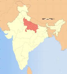
1244:{{WikiProject_India_Maps |Title=Uttar Pradesh locator map |Description=Locator map of the state of Uttar Pradesh,
308:
1688:
312:
304:
1758:
1728:
1673:
1583:
1493:
472:
316:
1633:
2076:
If the file has been modified from its original state, some details may not fully reflect the modified file.
2053:
1998:
1958:
1883:
1878:
1868:
1863:
1843:
1738:
1708:
1265:
More than 100 pages use this file. The following list shows the first 100 pages that use this file only. A
867:
1683:
1648:
509:– If you remix, transform, or build upon the material, you must distribute your contributions under the
1723:
1668:
843: : The territory India claims is legally theirs, but the claim is disputed by China and Pakistan.
293:
1196:
1191:
993:"}},"text\/plain":{"en":{"P6216":"copyrighted"}}}}": -->
42:
1988:
1913:
1848:
1808:
1703:
1273:
348:
883:
118:
1718:
1663:
1638:
1523:
1438:
1413:
795:
1628:
1553:
1428:
931:
1798:
1793:
1603:
1543:
1508:
1348:
469:
352:
1973:
1918:
407:
If you dont want to release your work under a creative commons license, please mail me at
8:
1608:
1588:
1563:
1333:
1573:
1448:
1378:
1353:
896:
764:
1613:
1578:
1308:
1214:{{Information |Description= |Source= |Date= |Author= |Permission= |other_versions= }}
105:
965:
444:
I, the copyright holder of this work, hereby publish it under the following license:
1658:
1618:
1598:
1568:
1558:
1483:
1473:
1458:
1298:
1288:
889:
879:
726:
397:
2013:
1993:
1898:
1828:
1593:
1443:
1403:
1388:
1283:
386:
1528:
1318:
336:
804:
320:
1423:
1252:
1237:
1207:
871:
825:
702:
689:
670:
657:
625:
612:
593:
580:
409:
344:
1548:
1538:
1358:
1249:
539:
131:
1533:
1393:
1368:
1138:
1098:
1054:
1010:
875:
644:
258:
1518:
1488:
1363:
1338:
899:
is almost entirely claimed by China as part of its
Tibetan territory.
750:
414:
132:
1513:
1503:
1478:
1433:
1343:
1313:
1278:
1164:
Click on a date/time to view the file as it appeared at that time.
878:). Since 1972, it is divided between all three countries. See also
815:
Please check local laws and modify the map accordingly before use.
300:
289:
1498:
1468:
1463:
1453:
1408:
1398:
1383:
1303:
1248:
with district boundaries. |Source=. |Date=August 6 2006 |Author=
332:
832:
1873:
1418:
1328:
1323:
245:
910:
For a detailed map of all disputed regions in South Asia, see
1373:
1293:
1245:
328:
87:(SVG file, nominally 1,574 × 1,738 pixels, file size: 836 KB)
271:
93:
866:
The northern
Himalayan region of the disputed territory
951:
Add a one-line explanation of what this file represents
735:
If inappropriate please set warp_status = skip to hide.
561:
174:
1263:
820:
1784:
1162:
1061:
Creative
Commons Attribution-ShareAlike 3.0 Unported
1035:
Creative Commons Attribution-ShareAlike 3.0 Unported
117:
Commons is a freely licensed media file repository.
721:
253:
745:
226:
569:
553:
164:
418:to negotiate a custom license as per your needs.
184:
1769:Category:WikiProject Uttar Pradesh participants
788:
857:
520:https://creativecommons.org/licenses/by-sa/3.0
98:
526:Creative Commons Attribution-Share Alike 3.0
450:
429:
267:
236:
756:
364:
277:
14:
486:– to copy, distribute and transmit the work
244:Locator map of the state of Uttar Pradesh,
46:Size of this PNG preview of this SVG file:
1624:User talk:Planemad/Infobox Indian Landmark
223:
1786:The following other wikis use this file:
874:) and the Chinese-occupied territory of (
1754:Template:User interest Uttar Pradesh/doc
557:second half of 20 century and 21 century
138:
1699:Template:User citizen Uttar Pradesh/doc
800:) and the National Geographic Society (
729:Georeference the map in Wikimaps Warper
204:
925:
396:If you are using the image under the
194:
129:
1749:Template:User interest Uttar Pradesh
473:Attribution-Share Alike 3.0 Unported
398:creative commons share alike license
1764:Category:Uttar Pradeshi Wikipedians
1694:Template:User citizen Uttar Pradesh
1654:Knowledge:WikiProject Uttar Pradesh
1155:
917:
461:
456:
239:India Uttar Pradesh locator map.svg
13:
2071:
1734:Template:User in Uttar Pradesh/doc
1679:Template:User WP Uttar Pradesh/doc
1644:Knowledge:Userboxes/Location/India
964:
958:
950:
912:Image:India disputed areas map.svg
831:
824:
821:Explanation of disputed boundaries
447:
443:
257:
179:Explanation of disputed boundaries
133:
130:
80:
2105:
2078:
963:
134:
1744:Template:User interest India/doc
1714:Template:User from Uttar Pradesh
941:
847:Line of Control/Line of Conflict
763:
643:
538:
497:Under the following conditions:
468:This file is licensed under the
460:
455:
449:
369:
144:
97:
31:
21:
1689:Template:User citizen India/doc
938:
870:is claimed by India including (
301:University of Texas map library
290:University of Texas map library
1781:
1759:Template:UttarPradesh-geo-stub
1729:Template:User in Uttar Pradesh
1674:Template:User WP Uttar Pradesh
1584:User:Life in General/Userboxes
1494:Saidpur Lok Sabha constituency
1159:
937:
895:The northeastern territory of
326:State and District boundaries:
218:
26:
1:
1634:User talk:Shivamchandravanshi
1105:original creation by uploader
1079:original creation by uploader
872:Pakistan-administered Kashmir
727:
36:
2049:टेम्पलेट:उत्तरप्रदेश-भू-आधार
1739:Template:User interest India
1709:Template:User from India/doc
1260:
971:Items portrayed in this file
789:Depiction of India's borders
372:
349:Survey of India Map Explorer
169:Depiction of India's borders
7:
2068:
1790:Usage on awa.wikipedia.org
1684:Template:User citizen India
1649:Knowledge:WikiProject India
868:Indian-administered Kashmir
858:Borders of disputed regions
402:CC-by-sa PlaneMad/Wikimedia
189:Borders of disputed regions
10:
2110:
1825:Usage on bh.wikipedia.org
1815:Usage on be.wikipedia.org
1805:Usage on ba.wikipedia.org
1724:Template:User in India/doc
1669:Template:User WP India/doc
573:
511:same or compatible license
154:
1929:घोसी लोकसभा चुनाव क्षेत्र
1156:
740:
548:
282:
248:with district boundaries.
231:Uttar Pradesh locator map
16:
1704:Template:User from India
1274:2002 Jaunpur train crash
940:
841:Boundary of Indian claim
783:
562:Spatial reference system
477:
400:please credit the photo
294:India Political map 2001
104:This is a file from the
41:
1819:Штаты і тэрыторыі Індыі
1243:
1213:
1192:07:11, 29 December 2008
108:. Information from its
1719:Template:User in India
1664:Template:User WP India
1639:User talk:Sonu me sonu
1524:Usman Enclave, Lucknow
1439:Kuthond, Uttar Pradesh
1414:Khanpur, Uttar Pradesh
934:for more information.
884:Line of Actual Control
836:
829:
751:WikiProject India Maps
549: Geotemporal data
333:2001 Census State Maps
287:International Borders:
262:
111:description page there
1629:User talk:RKumarSabga
1554:User:Brainmasterrohit
1429:Kurana, Uttar Pradesh
835:
828:
358:Map specific sources:
261:
1604:User:Siddhartha Ghai
1544:User:Awadhesh.Pandey
1509:Sirsi, Uttar Pradesh
1349:Dehra, Uttar Pradesh
1222:18:12, 6 August 2006
337:Survey of India Maps
74:1,574 × 1,738 pixels
70:1,855 × 2,048 pixels
1894:ललितपुर जिला (भारत)
1609:User:Suhebriazsaifi
1589:User:Mailabhimishra
1564:User:Faizhaider/UBX
1334:Chitrakoot division
1255:|Thumbdir=CHANGE }}
741: Archival data
492:– to adapt the work
353:Columbia University
345:US Army Map Service
317:Kashmir Region 2004
313:Western Sector 1988
309:Eastern Sector 1988
305:China-India Borders
52:Other resolutions:
1574:User:Khalidkoraivi
1449:Moradabad division
1379:Gorakhpur division
1354:Devipatan division
926:Territorial waters
837:
830:
412:or catch me at my
263:
209:Territorial waters
66:927 × 1,024 pixels
2097:
2096:
2063:more global usage
1904:भिरगू बाबा क कुटी
1782:Global file usage
1614:User:Sumitjaiswal
1579:User:Krantmlverma
1309:Bareilly division
1258:
1045:copyright license
1031:copyright license
957:
949:
897:Arunachal Pradesh
777:
776:
736:
717:
716:
438:
435:Reusing this file
424:
423:
298:Disputed Borders:
139:
126:
125:
106:Wikimedia Commons
32:Global file usage
2101:
2079:
2009:फूलपुर, इलाहाबाद
1944:अंबेडकर नगर जिला
1659:Template:User UP
1619:User:Utkarsh1992
1599:User:RohitSaxena
1569:User:Jamal.areeb
1559:User:Divyenduraj
1484:Ratnapuri, India
1474:Rajapur, Garwara
1459:Pura Gambhirshah
1299:Ayodhya division
1289:Aligarh division
1234:
1204:
1166:
1001:copyright status
987:copyright status
955:
947:
918:Internal borders
767:
734:
733:
731:
730:
713:
711:
710:
709:
704:
700:
699:
696:
695:
692:
681:
679:
678:
677:
672:
668:
667:
664:
663:
660:
647:
636:
634:
633:
632:
627:
623:
622:
619:
618:
615:
604:
602:
601:
600:
595:
591:
590:
587:
586:
583:
574:
542:
533:
530:
527:
524:
521:
513:as the original.
470:Creative Commons
464:
463:
459:
458:
453:
452:
432:
370:
284:
273:
272:29 December 2008
240:
224:
210:
207:
200:
199:Internal borders
197:
190:
187:
180:
177:
170:
167:
160:
157:
150:
147:
140:
122:
101:
100:
94:
88:
77:
62:695 × 768 pixels
58:435 × 480 pixels
54:217 × 240 pixels
48:543 × 600 pixels
2109:
2108:
2104:
2103:
2102:
2100:
2099:
2098:
2067:
2024:फर्रूखाबाद जिला
1780:
1594:User:Maquahuitl
1444:Meerut division
1404:Kanpur division
1389:Hasanpur Luhari
1284:Ahirauli Baghel
1259:
1253:w:user:Planemad
1240:
1232:
1210:
1202:
1158:
1157:
1154:
1153:
1152:
1151:
1150:
1149:
1148:
1147:
1145:
1135:
1134:
1133:
1131:
1116:
1115:
1114:
1113:
1112:
1111:
1110:
1109:
1107:
1095:
1094:
1093:
1091:
1072:
1071:
1070:
1069:
1068:
1067:
1066:
1065:
1063:
1051:
1050:
1049:
1047:
1028:
1027:
1026:
1025:
1024:
1023:
1022:
1021:
1019:
1007:
1006:
1005:
1003:
984:
983:
982:
981:
980:
978:
962:
961:
960:
953:
952:
928:
920:
890:Siachen glacier
880:Line of Control
860:
823:
791:
786:
778:
771:
768:
728:
725:
707:
705:
701:
697:
693:
690:
688:
686:
675:
673:
669:
665:
661:
658:
656:
654:
630:
628:
624:
620:
616:
613:
611:
609:
598:
596:
592:
588:
584:
581:
579:
577:
536:
535:
534:
531:
528:
525:
522:
519:
518:
476:
465:
446:
445:
425:
329:Census of India
249:
238:
232:
221:
216:
208:
205:
198:
195:
188:
185:
178:
175:
168:
165:
158:
155:
148:
145:
141:
137:
128:
127:
116:
115:
114:is shown below.
90:
86:
79:
78:
51:
12:
11:
5:
2107:
2095:
2094:
2091:
2087:
2086:
2083:
2070:
2065:of this file.
2059:
2058:
2057:
2056:
2051:
2046:
2041:
2036:
2031:
2026:
2021:
2016:
2011:
2006:
2001:
1996:
1991:
1986:
1981:
1976:
1971:
1966:
1961:
1956:
1954:राजेसुल्तानपुर
1951:
1949:गाजियाबाद जिला
1946:
1941:
1936:
1931:
1926:
1921:
1916:
1911:
1906:
1901:
1896:
1891:
1889:प्रयागराज जिला
1886:
1881:
1876:
1871:
1866:
1861:
1856:
1851:
1846:
1841:
1836:
1831:
1823:
1822:
1821:
1813:
1812:
1811:
1803:
1802:
1801:
1796:
1783:
1778:to this file.
1772:
1771:
1766:
1761:
1756:
1751:
1746:
1741:
1736:
1731:
1726:
1721:
1716:
1711:
1706:
1701:
1696:
1691:
1686:
1681:
1676:
1671:
1666:
1661:
1656:
1651:
1646:
1641:
1636:
1631:
1626:
1621:
1616:
1611:
1606:
1601:
1596:
1591:
1586:
1581:
1576:
1571:
1566:
1561:
1556:
1551:
1546:
1541:
1536:
1531:
1529:User:Adonis211
1526:
1521:
1516:
1511:
1506:
1501:
1496:
1491:
1486:
1481:
1476:
1471:
1466:
1461:
1456:
1451:
1446:
1441:
1436:
1431:
1426:
1421:
1416:
1411:
1406:
1401:
1396:
1391:
1386:
1381:
1376:
1371:
1366:
1361:
1356:
1351:
1346:
1341:
1336:
1331:
1326:
1321:
1319:Basti division
1316:
1311:
1306:
1301:
1296:
1291:
1286:
1281:
1276:
1269:is available.
1262:
1257:
1256:
1250:w:user:Nichalp
1242:
1238:
1235:
1231:1,639 × 1,852
1229:
1224:
1219:
1216:
1215:
1212:
1208:
1205:
1201:1,574 × 1,738
1199:
1194:
1189:
1185:
1184:
1181:
1178:
1175:
1172:
1169:
1161:
1146:
1143:
1141:
1140:
1139:
1137:
1136:
1132:
1127:
1125:
1124:
1123:
1122:
1120:
1108:
1103:
1101:
1100:
1099:
1097:
1096:
1092:
1089:source of file
1087:
1085:
1084:
1083:
1082:
1080:
1076:
1075:source of file
1064:
1059:
1057:
1056:
1055:
1053:
1052:
1048:
1043:
1041:
1040:
1039:
1038:
1036:
1032:
1020:
1015:
1013:
1012:
1011:
1009:
1008:
1004:
999:
997:
996:
995:
994:
992:
988:
979:
974:
972:
969:
968:
967:
966:
954:
946:
945:
942:
939:
927:
924:
919:
916:
907:
906:
903:
900:
893:
887:
876:Ladakh plateau
859:
856:
855:
854:
844:
822:
819:
818:
817:
811:
810:verifiability.
807:
790:
787:
785:
782:
775:
774:
773:
772:
769:
762:
758:
757:Other versions
754:
753:
747:
743:
742:
738:
737:
723:
722:Georeferencing
719:
718:
715:
714:
703:6.25°N 96.09°E
684:
682:
651:
650:
648:
641:
638:
637:
626:37.23°N 99.0°E
607:
605:
594:36.70°N 64.8°E
571:
567:
566:
563:
559:
558:
555:
551:
550:
546:
545:
517:
516:
515:
514:
504:
495:
494:
493:
487:
480:You are free:
467:
466:
448:
442:
441:
439:
427:
426:
422:
421:
420:
419:
405:
382:was created by
373:
368:
366:
362:
361:
342:Other sources:
279:
275:
274:
269:
265:
264:
255:
251:
250:
243:
241:
234:
233:
230:
228:
222:
220:
217:
215:
214:
213:
212:
202:
192:
182:
172:
152:
136:
124:
123:
102:
92:
91:
45:
40:
39:
34:
29:
24:
19:
9:
6:
4:
3:
2:
2106:
2092:
2089:
2088:
2084:
2081:
2080:
2077:
2074:
2066:
2064:
2055:
2052:
2050:
2047:
2045:
2042:
2040:
2037:
2035:
2032:
2030:
2027:
2025:
2022:
2020:
2017:
2015:
2012:
2010:
2007:
2005:
2002:
2000:
1997:
1995:
1992:
1990:
1987:
1985:
1982:
1980:
1977:
1975:
1972:
1970:
1967:
1965:
1962:
1960:
1957:
1955:
1952:
1950:
1947:
1945:
1942:
1940:
1937:
1935:
1932:
1930:
1927:
1925:
1924:नाथबाबा मंदिर
1922:
1920:
1917:
1915:
1912:
1910:
1907:
1905:
1902:
1900:
1897:
1895:
1892:
1890:
1887:
1885:
1882:
1880:
1877:
1875:
1872:
1870:
1867:
1865:
1862:
1860:
1857:
1855:
1852:
1850:
1847:
1845:
1842:
1840:
1837:
1835:
1832:
1830:
1827:
1826:
1824:
1820:
1817:
1816:
1814:
1810:
1807:
1806:
1804:
1800:
1797:
1795:
1792:
1791:
1789:
1788:
1787:
1779:
1777:
1770:
1767:
1765:
1762:
1760:
1757:
1755:
1752:
1750:
1747:
1745:
1742:
1740:
1737:
1735:
1732:
1730:
1727:
1725:
1722:
1720:
1717:
1715:
1712:
1710:
1707:
1705:
1702:
1700:
1697:
1695:
1692:
1690:
1687:
1685:
1682:
1680:
1677:
1675:
1672:
1670:
1667:
1665:
1662:
1660:
1657:
1655:
1652:
1650:
1647:
1645:
1642:
1640:
1637:
1635:
1632:
1630:
1627:
1625:
1622:
1620:
1617:
1615:
1612:
1610:
1607:
1605:
1602:
1600:
1597:
1595:
1592:
1590:
1587:
1585:
1582:
1580:
1577:
1575:
1572:
1570:
1567:
1565:
1562:
1560:
1557:
1555:
1552:
1550:
1547:
1545:
1542:
1540:
1537:
1535:
1532:
1530:
1527:
1525:
1522:
1520:
1517:
1515:
1512:
1510:
1507:
1505:
1502:
1500:
1497:
1495:
1492:
1490:
1487:
1485:
1482:
1480:
1477:
1475:
1472:
1470:
1467:
1465:
1462:
1460:
1457:
1455:
1452:
1450:
1447:
1445:
1442:
1440:
1437:
1435:
1432:
1430:
1427:
1425:
1424:Kukrail River
1422:
1420:
1417:
1415:
1412:
1410:
1407:
1405:
1402:
1400:
1397:
1395:
1392:
1390:
1387:
1385:
1382:
1380:
1377:
1375:
1372:
1370:
1367:
1365:
1362:
1360:
1357:
1355:
1352:
1350:
1347:
1345:
1342:
1340:
1337:
1335:
1332:
1330:
1327:
1325:
1322:
1320:
1317:
1315:
1312:
1310:
1307:
1305:
1302:
1300:
1297:
1295:
1292:
1290:
1287:
1285:
1282:
1280:
1277:
1275:
1272:
1271:
1270:
1268:
1254:
1251:
1247:
1241:
1236:
1230:
1228:
1225:
1223:
1220:
1218:
1217:
1211:
1206:
1200:
1198:
1195:
1193:
1190:
1187:
1186:
1182:
1179:
1176:
1173:
1170:
1168:
1167:
1165:
1144:image/svg+xml
1142:
1130:
1126:
1106:
1102:
1090:
1086:
1062:
1058:
1046:
1042:
1018:
1014:
1002:
998:
977:
973:
970:
943:
936:
935:
933:
923:
915:
914:
913:
904:
901:
898:
894:
891:
888:
885:
881:
877:
873:
869:
865:
864:
863:
852:
848:
845:
842:
839:
838:
834:
827:
816:
812:
808:
805:
802:
799:
796:
793:
792:
781:
780:
766:
761:
760:
759:
755:
752:
748:
744:
739:
732:
724:
720:
712:
685:
683:
680:
671:5.9°N 68.76°E
653:
652:
649:
646:
642:
640:
639:
635:
608:
606:
603:
576:
575:
572:
568:
564:
560:
556:
554:Date depicted
552:
547:
541:
537:
523:CC BY-SA 3.0
512:
508:
505:
502:
499:
498:
496:
491:
488:
485:
482:
481:
479:
478:
474:
471:
454:
440:
436:
431:
428:
417:
416:
411:
410:
406:
403:
399:
395:
394:
393:
392:
389:
388:
387:User:PlaneMad
384:
383:
380:
379:
374:
371:
367:
363:
359:
356:
355:
354:
350:
346:
343:
340:
338:
334:
330:
327:
324:
322:
318:
314:
310:
306:
302:
299:
296:
295:
291:
288:
285:
280:
276:
270:
266:
260:
256:
252:
247:
242:
235:
229:
225:
211:
203:
201:
193:
191:
183:
181:
173:
171:
163:
162:
161:
153:
151:
143:
142:
120:
113:
112:
107:
103:
96:
95:
89:
84:
83:Original file
75:
71:
67:
63:
59:
55:
49:
44:
38:
35:
33:
30:
28:
25:
23:
20:
18:
15:
2075:
2072:
2060:
1939:वाराणसी जिला
1934:अयोध्या जिला
1854:देवरिया जिला
1834:गाजीपुर जिला
1785:
1773:
1549:User:B.arjun
1539:User:Atif.t2
1359:Dhaura Tanda
1264:
1163:
1160:File history
929:
921:
909:
908:
861:
850:
849: : The
846:
840:
814:
779:
570:Bounding box
506:
500:
489:
483:
413:
408:
401:
390:
385:
381:
377:
375:
357:
341:
325:
321:Kashmir Maps
297:
286:
281:
119:You can help
109:
81:
22:File history
2029:कन्नौज जिला
1859:जौनपुर जिला
1534:User:Ajykam
1394:Jamni River
1369:Gajadharpur
1017:copyrighted
991:copyrighted
708:6.25; 96.09
631:37.23; 99.0
599:36.70; 64.8
507:share alike
501:attribution
237:Description
219:Утар Прадеш
149:Утар Прадеш
2019:बस्ती जिला
1776:more links
1519:Teji Bazar
1489:Sahijadpur
1364:Fort Ruhya
1339:Daiya Bojh
1261:File usage
1177:Dimensions
1129:media type
1119:media type
676:5.9; 68.76
430:Permission
378:This Image
254:Map legend
27:File usage
2039:मेरठ जिला
2034:लखनऊ जिला
2004:मुट्ठीगंज
1969:कंपनी बाग
1964:सुरहा ताल
1909:सिकंदरपुर
1809:Һиндостан
1267:full list
1174:Thumbnail
1171:Date/Time
770:blank map
2069:Metadata
2044:बाँसगाँव
1984:चित्रकूट
1979:कौशाम्बी
1839:नजीबाबाद
1514:Sonahita
1504:Sidhpura
1479:Ramaipur
1434:Kurebhar
1344:Dehduwar
1314:Barokhar
1279:Achakari
1239:Planemad
1233:(751 KB)
1209:Planemad
1203:(836 KB)
944:Captions
851:de facto
749:Part of
490:to remix
484:to share
475:license.
283:Own work
135:Contents
37:Metadata
2054:बाँसडीह
1999:दारागंज
1959:मछलीशहर
1884:सोनाडीह
1879:पड़रौना
1869:गोरखपुर
1864:गाजीपुर
1844:कुशीनगर
1499:Sankhni
1469:Purmafi
1464:Puralal
1454:Narauli
1409:Kewtali
1399:Kandhla
1384:Gunnaur
1304:Barehta
1188:current
1183:Comment
976:depicts
948:English
694:96°05′E
662:68°46′E
617:99°00′E
614:37°14′N
585:64°48′E
582:36°42′N
415:Website
365:Creator
85:
2093:1738px
2090:Height
2085:1574px
1989:कन्नौज
1914:बैरिया
1849:आजमगढ़
1419:Kotaha
1329:Biwanr
1324:Bilram
691:6°15′N
659:5°54′N
544:usage.
311:&
278:Source
2082:Width
2061:View
1974:झूँसी
1919:मनियर
1799:हरदोई
1794:इटावा
1774:View
1374:Gawan
1294:Arbar
1246:India
959:हिंदी
956:Hindi
784:Notes
746:Notes
565:conic
246:India
227:Title
159:Notes
2014:नैनी
1994:कड़ा
1899:मेरठ
1829:आगरा
1180:User
932:this
882:and
532:true
529:true
268:Date
17:File
698:/
666:/
621:/
589:/
206:2.5
196:2.4
186:2.3
176:2.2
166:2.1
1874:मऊ
803:,
797:,
706:/
674:/
629:/
597:/
351:,
347:,
335:-
331:-
319:-
315:-
307:-
303:-
292:-
72:|
68:|
64:|
60:|
56:|
50:.
886:.
806:)
437:)
433:(
391:.
360:.
339:.
323:.
156:2
146:1
121:.
76:.
Text is available under the Creative Commons Attribution-ShareAlike License. Additional terms may apply.

