841:"}},"text\/plain":{"en":{"":"coordinates of depicted place"}}},"{\"value\":{\"latitude\":55.92402,\"longitude\":-4.37349,\"altitude\":null,\"precision\":1.0e-5,\"globe\":\"http:\\\/\\\/www.wikidata.org\\\/entity\\\/Q2\"},\"type\":\"globecoordinate\"}":{"text\/html":{"en":{"P9149":"55\u00b055'26.47"N, 4\u00b022'24.56"W"}},"text\/plain":{"en":{"P9149":"55\u00b055'26.47\"N, 4\u00b022'24.56\"W"}}},"{\"value\":{\"entity-type\":\"property\",\"numeric-id\":7787,\"id\":\"P7787\"},\"type\":\"wikibase-entityid\"}":{"text\/html":{"en":{"":"
449:"}},"text\/plain":{"en":{"":"author name string"}}},"{\"value\":\"Thomas Nugent\",\"type\":\"string\"}":{"text\/html":{"en":{"P2093":"Thomas Nugent"}},"text\/plain":{"en":{"P2093":"Thomas Nugent"}}},"{\"value\":{\"entity-type\":\"property\",\"numeric-id\":2699,\"id\":\"P2699\"},\"type\":\"wikibase-entityid\"}":{"text\/html":{"en":{"":"
759:"}},"text\/plain":{"en":{"":"inception"}}},"{\"value\":{\"time\":\"+2016-01-04T00:00:00Z\",\"timezone\":0,\"before\":0,\"after\":0,\"precision\":11,\"calendarmodel\":\"http:\\\/\\\/www.wikidata.org\\\/entity\\\/Q1985727\"},\"type\":\"time\"}":{"text\/html":{"en":{"P571":"4 January 2016"}},"text\/plain":{"en":{"P571":"4 January 2016"}}}}": -->
636:
242:
837:
256:
277:
315:
320:
67:
1037:"}},"text\/plain":{"en":{"":"ISO speed"}}},"{\"value\":{\"amount\":\"+400\",\"unit\":\"1\"},\"type\":\"quantity\"}":{"text\/html":{"en":{"P6789":"400"}},"text\/plain":{"en":{"P6789":"400"}}}}": -->
954:"}},"text\/plain":{"en":{"":"f-number"}}},"{\"value\":{\"amount\":\"+4.6\",\"unit\":\"1\"},\"type\":\"quantity\"}":{"text\/html":{"en":{"P6790":"4.6"}},"text\/plain":{"en":{"P6790":"4.6"}}}}": -->
457:"}},"text\/plain":{"en":{"P2699":"https:\/\/www.geograph.org.uk\/profile\/4827"}}},"{\"value\":{\"entity-type\":\"property\",\"numeric-id\":3831,\"id\":\"P3831\"},\"type\":\"wikibase-entityid\"}":{"text\/html":{"en":{"":"
660:"}},"text\/plain":{"en":{"P973":"https:\/\/www.geograph.org.uk\/photo\/4786933"}}},"{\"value\":{\"entity-type\":\"property\",\"numeric-id\":137,\"id\":\"P137\"},\"type\":\"wikibase-entityid\"}":{"text\/html":{"en":{"":"
644:"}},"text\/plain":{"en":{"P7482":"file available on the internet"}}},"{\"value\":{\"entity-type\":\"property\",\"numeric-id\":7384,\"id\":\"P7384\"},\"type\":\"wikibase-entityid\"}":{"text\/html":{"en":{"":"
461:"}},"text\/plain":{"en":{"":"object of statement has role"}}},"{\"value\":{\"entity-type\":\"item\",\"numeric-id\":33231,\"id\":\"Q33231\"},\"type\":\"wikibase-entityid\"}":{"text\/html":{"en":{"P3831":"
909:"}},"text\/plain":{"en":{"":"exposure time"}}},"{\"value\":{\"amount\":\"+0.003125\",\"unit\":\"http:\\\/\\\/www.wikidata.org\\\/entity\\\/Q11574\"},\"type\":\"quantity\"}":{"text\/html":{"en":{"P6757":"0.003125
1075:"}},"text\/plain":{"en":{"":"media type"}}},"{\"value\":\"image\\\/jpeg\",\"type\":\"string\"}":{"text\/html":{"en":{"P1163":"image\/jpeg"}},"text\/plain":{"en":{"P1163":"image\/jpeg"}}}}": -->
596:"}},"text\/plain":{"en":{"":"copyright license"}}},"{\"value\":{\"entity-type\":\"item\",\"numeric-id\":19068220,\"id\":\"Q19068220\"},\"type\":\"wikibase-entityid\"}":{"text\/html":{"en":{"P275":"
552:"}},"text\/plain":{"en":{"":"copyright status"}}},"{\"value\":{\"entity-type\":\"item\",\"numeric-id\":50423863,\"id\":\"Q50423863\"},\"type\":\"wikibase-entityid\"}":{"text\/html":{"en":{"P6216":"
992:"}},"text\/plain":{"en":{"":"focal length"}}},"{\"value\":{\"amount\":\"+15.15\",\"unit\":\"http:\\\/\\\/www.wikidata.org\\\/entity\\\/Q174789\"},\"type\":\"quantity\"}":{"text\/html":{"en":{"P2151":"15.15
640:"}},"text\/plain":{"en":{"":"source of file"}}},"{\"value\":{\"entity-type\":\"item\",\"numeric-id\":74228490,\"id\":\"Q74228490\"},\"type\":\"wikibase-entityid\"}":{"text\/html":{"en":{"P7482":"
797:"}},"text\/plain":{"en":{"":"captured with"}}},"{\"value\":{\"entity-type\":\"item\",\"numeric-id\":17049127,\"id\":\"Q17049127\"},\"type\":\"wikibase-entityid\"}":{"text\/html":{"en":{"P4082":"
1113:"}},"text\/plain":{"en":{"":"instance of"}}},"{\"value\":{\"entity-type\":\"item\",\"numeric-id\":125191,\"id\":\"Q125191\"},\"type\":\"wikibase-entityid\"}":{"text\/html":{"en":{"P31":"
845:"}},"text\/plain":{"en":{"":"heading"}}},"{\"value\":{\"amount\":\"+315\",\"unit\":\"http:\\\/\\\/www.wikidata.org\\\/entity\\\/Q28390\"},\"type\":\"quantity\"}":{"text\/html":{"en":{"P7787":"315
664:"}},"text\/plain":{"en":{"":"operator"}}},"{\"value\":{\"entity-type\":\"item\",\"numeric-id\":1503119,\"id\":\"Q1503119\"},\"type\":\"wikibase-entityid\"}":{"text\/html":{"en":{"P137":"
652:"}},"text\/plain":{"en":{"P7384":"4786933"}}},"{\"value\":{\"entity-type\":\"property\",\"numeric-id\":973,\"id\":\"P973\"},\"type\":\"wikibase-entityid\"}":{"text\/html":{"en":{"":"
1195:
445:"}},"text\/plain":{"en":{"":"creator"}}},"{\"value\":{\"entity-type\":\"property\",\"numeric-id\":2093,\"id\":\"P2093\"},\"type\":\"wikibase-entityid\"}":{"text\/html":{"en":{"":"
1071:
225:
648:"}},"text\/plain":{"en":{"":"geograph.org.uk image ID"}}},"{\"value\":\"4786933\",\"type\":\"string\"}":{"text\/html":{"en":{"P7384":"
367:– You must give appropriate credit, provide a link to the license, and indicate if changes were made. You may do so in any reasonable manner, but not in any way that suggests the licensor endorses you or your use.
1343:
239:
46:
78:
649:
798:
641:
597:
553:
665:
1114:
462:
1072:
1034:
989:
951:
906:
842:
838:
794:
645:
637:
549:
458:
450:
446:
657:
756:
661:
653:
593:
454:
442:
1110:
600:"}},"text\/plain":{"en":{"P275":"Creative Commons Attribution-ShareAlike 2.0 Generic"}}}}": -->
162:
824:
691:
623:
579:
249:
741:
284:
1237:
This file contains additional information, probably added from the digital camera or scanner used to create or digitize it.
1140:
374:
534:
1194:
1189:
1082:
1044:
1003:
961:
920:
883:
856:
808:
704:
675:
563:
527:
512:
499:
37:
766:
734:
719:
607:
472:
431:
668:"}},"text\/plain":{"en":{"P137":"Geograph Britain and Ireland"}}}}": -->
1124:
801:"}},"text\/plain":{"en":{"P4082":"Panasonic Lumix DMC-FZ72"}}}}": -->
1374:
330:
1240:
If the file has been modified from its original state, some details may not fully reflect the modified file.
996:"}},"text\/plain":{"en":{"P2151":"15.15 millimetre"}}}}": -->
913:"}},"text\/plain":{"en":{"P6757":"0.003125 second"}}}}": -->
373:– If you remix, transform, or build upon the material, you must distribute your contributions under the
291:
on the
Geograph website for the photographer's contact details. The copyright on this image is owned by
465:"}},"text\/plain":{"en":{"P3831":"photographer"}}}}": -->
556:"}},"text\/plain":{"en":{"P6216":"copyrighted"}}}}": -->
1222:
The following pages on the
English Knowledge use this file (pages on other projects are not listed):
849:"}},"text\/plain":{"en":{"P7787":"315 degree"}}}}": -->
1117:"}},"text\/plain":{"en":{"P31":"photograph"}}}}": -->
86:
1422:
726:
711:
519:
327:
178:
8:
1458:
271:
255:
1571:
296:
73:
421:
194:
1205:
1526:
1440:
1274:
141:
1581:
1536:
1314:
151:
1134:
1092:
1054:
1013:
971:
930:
866:
818:
776:
685:
617:
573:
482:
1476:
276:
1294:
288:
1249:
1591:
1284:
1259:
1226:
1162:
Click on a date/time to view the file as it appeared at that time.
241:
226:
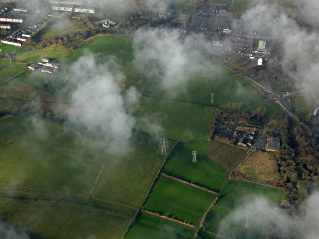
55° 55′ 26.5″ N, 4° 22′ 25″ W
130:
61:
415:
Add a one-line explanation of what this file represents
1220:
1160:
169:
Creative
Commons Attribution Share-alike license 2.0
85:
Commons is a freely licensed media file repository.
624:
Creative
Commons Attribution-ShareAlike 2.0 Generic
598:
Creative
Commons Attribution-ShareAlike 2.0 Generic
111:Hutcheson Hill from the air (geograph 4786933).jpg
47:Hutcheson_Hill_from_the_air_(geograph_4786933).jpg
1344:Embettered by PicMonkey. http://www.picmonkey.com
51:(640 × 480 pixels, file size: 120 KB, MIME type:
1463:Flash did not fire, compulsory flash suppression
384:https://creativecommons.org/licenses/by-sa/2.0
66:
658:https:\/\/www.geograph.org.uk\/photo\/4786933
390:Creative Commons Attribution-Share Alike 2.0
308:
157:
126:
108:
455:https:\/\/www.geograph.org.uk\/profile\/4827
147:
136:
14:
993:
910:
846:
350:– to copy, distribute and transmit the work
727:https://www.geograph.org.uk/photo/4786933
520:https://www.geograph.org.uk/profile/4827
1212:Transferred from geograph.co.uk using
248:View this and other nearby images on:
201:
97:
295:and is licensed for reuse under the
216:
1153:
331:Attribution-Share Alike 2.0 Generic
319:
314:
299:Attribution-ShareAlike 2.0 license.
13:
1235:
420:
414:
305:
282:
115:
98:
44:
1624:
1242:
419:
1604:0adefe79a9bbed2d33b416915b988690
1305:Date and time of data generation
1221:
405:
361:Under the following conditions:
326:This file is licensed under the
318:
313:
307:
275:
254:
240:
232:
65:
21:
402:
116:
41:No higher resolution available.
1157:
692:file available on the internet
642:file available on the internet
401:
283:This image was taken from the
26:
1:
1505:A directly photographed image
857:coordinates of depicted place
839:coordinates of depicted place
31:
1217:
742:Geograph Britain and Ireland
666:Geograph Britain and Ireland
528:object of statement has role
459:object of statement has role
427:Items portrayed in this file
267:
231:
7:
1385:Date and time of digitizing
1232:
872:55°55'26.47"N, 4°22'24.56"W
209:Hutcheson Hill from the air
190:Hutcheson Hill from the air
121:Hutcheson Hill from the air
10:
1629:
1547:Focal length in 35 mm film
1489:One-chip color area sensor
1468:Supported Flashpix version
375:same or compatible license
207:Thomas Nugent /
188:Thomas Nugent /
105:
100:
1393:Meaning of each component
1350:File change date and time
1154:
16:
825:Panasonic Lumix DMC-FZ72
799:Panasonic Lumix DMC-FZ72
705:geograph.org.uk image ID
646:geograph.org.uk image ID
404:
341:
72:This is a file from the
36:
1510:Custom image processing
1211:
179:required by the license
129:
76:. Information from its
1414:Image compression mode
289:this photograph's page
260:55.924020; -4.373490
79:description page there
1432:Maximum land aperture
1388:13:15, 4 January 2016
1353:17:10, 8 January 2016
1324:Horizontal resolution
1308:13:15, 4 January 2016
1531:Manual white balance
1497:Digital still camera
1435:4.40625 APEX (f/4.6)
1279:1/320 sec (0.003125)
1358:Y and C positioning
1332:Vertical resolution
1246:Camera manufacturer
1190:16:39, 3 March 2018
356:– to adapt the work
1555:Scene capture type
500:author name string
447:author name string
1616:
1615:
1215:
995:
912:
848:
608:copyright license
594:copyright license
413:
304:
303:
287:collection. See
265:
264:
214:
213:
182:
166:
163:Reusing this file
94:
93:
74:Wikimedia Commons
1620:
1366:Exposure Program
1243:
1202:
1164:
1022:
939:
894:
893:
888:
744:
739:
729:
724:
720:described at URL
714:
709:
654:described at URL
564:copyright status
550:copyright status
537:
532:
522:
517:
507:
504:
411:
397:
394:
391:
388:
385:
377:as the original.
339:
328:Creative Commons
322:
321:
317:
316:
311:
310:
297:Creative Commons
285:Geograph project
279:
272:
261:
258:
244:
243:
237:
236:
235:
229:
228:
217:
176:
160:
132:
120:
112:
106:
90:
69:
68:
62:
56:
54:
1628:
1627:
1623:
1622:
1621:
1619:
1618:
1617:
1601:Unique image ID
1231:
1223:
1216:
1208:
1200:
1156:
1155:
1152:
1151:
1150:
1149:
1148:
1147:
1146:
1145:
1143:
1131:
1130:
1129:
1127:
1108:
1107:
1106:
1105:
1104:
1103:
1102:
1101:
1099:
1089:
1088:
1087:
1085:
1070:
1069:
1068:
1067:
1066:
1065:
1064:
1063:
1061:
1051:
1050:
1049:
1047:
1032:
1031:
1030:
1029:
1028:
1027:
1026:
1025:
1023:
1020:
1010:
1009:
1008:
1006:
987:
986:
985:
984:
983:
982:
981:
980:
978:
968:
967:
966:
964:
949:
948:
947:
946:
945:
944:
943:
942:
940:
937:
927:
926:
925:
923:
904:
903:
902:
901:
900:
899:
898:
897:
896:
895:
891:
889:
886:
877:
876:
875:
873:
863:
862:
861:
859:
836:
835:
834:
833:
832:
831:
830:
829:
827:
815:
814:
813:
811:
792:
791:
790:
789:
788:
787:
786:
785:
783:
773:
772:
771:
769:
754:
753:
752:
751:
750:
749:
748:
747:
746:
745:
740:
737:
731:
730:
725:
722:
716:
715:
710:
707:
698:
697:
696:
694:
682:
681:
680:
678:
635:
634:
633:
632:
631:
630:
629:
628:
626:
614:
613:
612:
610:
591:
590:
589:
588:
587:
586:
585:
584:
582:
570:
569:
568:
566:
547:
546:
545:
544:
543:
542:
541:
540:
539:
538:
533:
530:
524:
523:
518:
515:
509:
508:
505:
502:
493:
492:
491:
489:
479:
478:
477:
475:
440:
439:
438:
437:
436:
434:
418:
417:
416:
399:
398:
395:
392:
389:
386:
383:
382:
340:
337:
334:
323:
300:
270:
259:
233:
224:
223:
220:Object location
215:
204:
197:
185:
142:geograph.org.uk
122:
110:
103:
96:
95:
84:
83:
82:is shown below.
58:
52:
50:
43:
42:
12:
11:
5:
1626:
1614:
1613:
1610:
1606:
1605:
1602:
1598:
1597:
1594:
1588:
1587:
1584:
1578:
1577:
1574:
1568:
1567:
1564:
1560:
1559:
1556:
1552:
1551:
1548:
1544:
1543:
1540:
1533:
1532:
1529:
1523:
1522:
1519:
1515:
1514:
1513:Normal process
1511:
1507:
1506:
1503:
1499:
1498:
1495:
1491:
1490:
1487:
1486:Sensing method
1483:
1482:
1479:
1473:
1472:
1469:
1465:
1464:
1461:
1455:
1454:
1451:
1447:
1446:
1443:
1437:
1436:
1433:
1429:
1428:
1425:
1419:
1418:
1415:
1411:
1410:
1409:
1408:
1407:does not exist
1405:
1402:
1399:
1394:
1390:
1389:
1386:
1382:
1381:
1378:
1371:
1370:
1369:Normal program
1367:
1363:
1362:
1359:
1355:
1354:
1351:
1347:
1346:
1341:
1337:
1336:
1333:
1329:
1328:
1325:
1321:
1320:
1317:
1310:
1309:
1306:
1302:
1301:
1298:
1291:
1290:
1287:
1281:
1280:
1277:
1271:
1270:
1267:
1263:
1262:
1257:
1253:
1252:
1247:
1234:
1230:
1229:
1219:
1214:
1213:
1210:
1206:
1203:
1197:
1192:
1187:
1183:
1182:
1179:
1176:
1173:
1170:
1167:
1159:
1144:
1139:
1137:
1136:
1135:
1133:
1132:
1128:
1123:
1121:
1120:
1119:
1118:
1116:
1112:
1100:
1097:
1095:
1094:
1093:
1091:
1090:
1086:
1081:
1079:
1078:
1077:
1076:
1074:
1062:
1059:
1057:
1056:
1055:
1053:
1052:
1048:
1043:
1041:
1040:
1039:
1038:
1036:
1024:
1018:
1016:
1015:
1014:
1012:
1011:
1007:
1002:
1000:
999:
998:
997:
991:
979:
976:
974:
973:
972:
970:
969:
965:
960:
958:
957:
956:
955:
953:
941:
935:
933:
932:
931:
929:
928:
924:
919:
917:
916:
915:
914:
908:
882:
881:
880:
879:
878:
874:
871:
869:
868:
867:
865:
864:
860:
855:
853:
852:
851:
850:
844:
840:
828:
823:
821:
820:
819:
817:
816:
812:
807:
805:
804:
803:
802:
800:
796:
784:
782:4 January 2016
781:
779:
778:
777:
775:
774:
770:
765:
763:
762:
761:
760:
758:
733:
732:
718:
717:
703:
702:
701:
700:
699:
695:
690:
688:
687:
686:
684:
683:
679:
676:source of file
674:
672:
671:
670:
669:
667:
663:
659:
655:
651:
647:
643:
639:
638:source of file
627:
622:
620:
619:
618:
616:
615:
611:
606:
604:
603:
602:
601:
599:
595:
583:
578:
576:
575:
574:
572:
571:
567:
562:
560:
559:
558:
557:
555:
551:
526:
525:
511:
510:
498:
497:
496:
495:
494:
490:
487:
485:
484:
483:
481:
480:
476:
471:
469:
468:
467:
466:
464:
460:
456:
452:
448:
444:
435:
430:
428:
425:
424:
423:
422:
410:
409:
406:
403:
381:
380:
379:
378:
368:
359:
358:
357:
351:
344:You are free:
335:
325:
324:
306:
302:
301:
280:
269:
266:
263:
262:
252:
246:
221:
212:
211:
205:
202:
199:
198:
193:
186:
183:
171:
170:
167:
155:
154:
149:
145:
144:
138:
134:
133:
131:4 January 2016
128:
124:
123:
113:
104:
102:
99:
92:
91:
70:
60:
59:
40:
35:
34:
29:
24:
19:
9:
6:
4:
3:
2:
1625:
1611:
1608:
1607:
1603:
1600:
1599:
1595:
1593:
1590:
1589:
1585:
1583:
1580:
1579:
1575:
1573:
1570:
1569:
1565:
1563:Scene control
1562:
1561:
1557:
1554:
1553:
1549:
1546:
1545:
1541:
1538:
1535:
1534:
1530:
1528:
1527:White balance
1525:
1524:
1521:Auto exposure
1520:
1518:Exposure mode
1517:
1516:
1512:
1509:
1508:
1504:
1501:
1500:
1496:
1493:
1492:
1488:
1485:
1484:
1480:
1478:
1475:
1474:
1470:
1467:
1466:
1462:
1460:
1457:
1456:
1452:
1449:
1448:
1444:
1442:
1441:Metering mode
1439:
1438:
1434:
1431:
1430:
1426:
1424:
1423:Exposure bias
1421:
1420:
1416:
1413:
1412:
1406:
1403:
1400:
1397:
1396:
1395:
1392:
1391:
1387:
1384:
1383:
1379:
1376:
1373:
1372:
1368:
1365:
1364:
1360:
1357:
1356:
1352:
1349:
1348:
1345:
1342:
1340:Software used
1339:
1338:
1334:
1331:
1330:
1326:
1323:
1322:
1318:
1316:
1312:
1311:
1307:
1304:
1303:
1299:
1296:
1293:
1292:
1288:
1286:
1283:
1282:
1278:
1276:
1275:Exposure time
1273:
1272:
1268:
1265:
1264:
1261:
1258:
1255:
1254:
1251:
1248:
1245:
1244:
1241:
1238:
1228:
1225:
1224:
1209:
1204:
1198:
1196:
1193:
1191:
1188:
1185:
1184:
1180:
1177:
1174:
1171:
1168:
1166:
1165:
1163:
1142:
1138:
1126:
1122:
1096:
1084:
1080:
1058:
1046:
1042:
1017:
1005:
1001:
975:
963:
959:
934:
922:
921:exposure time
918:
907:exposure time
885:
870:
858:
854:
826:
822:
810:
809:captured with
806:
795:captured with
780:
768:
764:
743:
736:
728:
721:
713:
706:
693:
689:
677:
673:
625:
621:
609:
605:
581:
577:
565:
561:
536:
529:
521:
514:
506:Thomas Nugent
501:
486:
474:
470:
433:
429:
426:
407:
400:
387:CC BY-SA 2.0
376:
372:
369:
366:
363:
362:
360:
355:
352:
349:
346:
345:
343:
342:
338:Thomas Nugent
336:Attribution:
332:
329:
312:
298:
294:
293:Thomas Nugent
290:
286:
281:
278:
274:
273:
257:
253:
251:
250:OpenStreetMap
247:
245:
227:
222:
219:
218:
210:
206:
200:
196:
192: /
191:
187:
180:
175:
173:
172:
168:
164:
159:
156:
153:
152:Thomas Nugent
150:
146:
143:
139:
135:
125:
119:
114:
107:
88:
81:
80:
75:
71:
64:
63:
57:
48:
39:
33:
30:
28:
25:
23:
20:
18:
15:
1566:High gain up
1537:Digital zoom
1450:Light source
1315:focal length
1256:Camera model
1239:
1236:
1161:
1158:File history
1004:focal length
990:focal length
535:photographer
463:photographer
370:
364:
353:
347:
292:
230:
208:
195:CC BY-SA 2.0
189:
117:
87:You can help
77:
45:
22:File history
1609:IIM version
1494:File source
1477:Color space
1125:instance of
1111:instance of
580:copyrighted
554:copyrighted
371:share alike
365:attribution
174:Attribution
109:Description
1582:Saturation
1502:Scene type
1218:File usage
1207:AndrasSkot
1199:640 × 480
1175:Dimensions
1141:photograph
1115:photograph
1098:image/jpeg
1083:media type
1073:media type
1021:millimetre
994:millimetre
488:some value
158:Permission
53:image/jpeg
27:File usage
1592:Sharpness
1295:ISO speed
1250:Panasonic
1172:Thumbnail
1169:Date/Time
1045:ISO speed
1035:ISO speed
936:0.003125
767:inception
757:inception
268:Licensing
203:InfoField
184:InfoField
118:English:
1572:Contrast
1558:Standard
1361:Co-sited
1319:15.15 mm
1285:F-number
1260:DMC-FZ72
1233:Metadata
1227:Cleddans
1201:(120 KB)
962:f-number
952:f-number
735:operator
662:operator
408:Captions
354:to remix
348:to share
333:license.
32:Metadata
1453:Unknown
1445:Pattern
1377:version
1335:180 dpi
1327:180 dpi
1186:current
1181:Comment
884:heading
843:heading
712:4786933
650:4786933
473:creator
443:creator
432:depicts
412:English
101:Summary
49:
1596:Normal
1586:Normal
1576:Normal
1297:rating
1269:Picasa
1266:Author
1019:15.15
938:second
911:second
892:degree
847:degree
238:
148:Author
137:Source
1550:85 mm
1539:ratio
1459:Flash
1313:Lens
1289:f/4.6
140:From
1481:sRGB
1375:Exif
1178:User
890:315
396:true
393:true
127:Date
17:File
1380:2.3
1300:400
1060:400
977:4.6
513:URL
451:URL
1404:Cr
1401:Cb
887::
738::
723::
708::
531::
516::
503::
1612:4
1542:0
1471:1
1427:0
1417:4
1398:Y
181:)
177:(
165:)
161:(
89:.
55:)
.jpg)
.jpg¶ms=055.924020_N_-004.373490_E_globe:Earth_class:object_type:object_source:geograph-osgb36(NS51797265)_heading:315.00&language=en)
