837:"}},"text\/plain":{"en":{"":"coordinates of the point of view"}}},"{\"value\":{\"latitude\":51.04799,\"longitude\":-1.2487,\"altitude\":null,\"precision\":1.0e-5,\"globe\":\"http:\\\/\\\/www.wikidata.org\\\/entity\\\/Q2\"},\"type\":\"globecoordinate\"}":{"text\/html":{"en":{"P1259":"51\u00b02'52.76"N, 1\u00b014'55.32"W"}},"text\/plain":{"en":{"P1259":"51\u00b02'52.76\"N, 1\u00b014'55.32\"W"}}},"{\"value\":{\"entity-type\":\"property\",\"numeric-id\":7787,\"id\":\"P7787\"},\"type\":\"wikibase-entityid\"}":{"text\/html":{"en":{"":"
905:"}},"text\/plain":{"en":{"":"coordinates of depicted place"}}},"{\"value\":{\"latitude\":51.0495,\"longitude\":-1.2465,\"altitude\":null,\"precision\":1.0e-5,\"globe\":\"http:\\\/\\\/www.wikidata.org\\\/entity\\\/Q2\"},\"type\":\"globecoordinate\"}":{"text\/html":{"en":{"P9149":"51\u00b02'58.20"N, 1\u00b014'47.40"W"}},"text\/plain":{"en":{"P9149":"51\u00b02'58.20\"N, 1\u00b014'47.40\"W"}}},"{\"value\":{\"entity-type\":\"property\",\"numeric-id\":7787,\"id\":\"P7787\"},\"type\":\"wikibase-entityid\"}":{"text\/html":{"en":{"":"
497:"}},"text\/plain":{"en":{"":"author name string"}}},"{\"value\":\"Martyn Pattison\",\"type\":\"string\"}":{"text\/html":{"en":{"P2093":"Martyn Pattison"}},"text\/plain":{"en":{"P2093":"Martyn Pattison"}}},"{\"value\":{\"entity-type\":\"property\",\"numeric-id\":2699,\"id\":\"P2699\"},\"type\":\"wikibase-entityid\"}":{"text\/html":{"en":{"":"
799:"}},"text\/plain":{"en":{"":"inception"}}},"{\"value\":{\"time\":\"+2005-05-29T00:00:00Z\",\"timezone\":0,\"before\":0,\"after\":0,\"precision\":11,\"calendarmodel\":\"http:\\\/\\\/www.wikidata.org\\\/entity\\\/Q1985727\"},\"type\":\"time\"}":{"text\/html":{"en":{"P571":"29 May 2005"}},"text\/plain":{"en":{"P571":"29 May 2005"}}}}": -->
676:
481:
232:
901:
224:
296:
246:
317:
355:
360:
72:
1049:
684:"}},"text\/plain":{"en":{"P7482":"file available on the internet"}}},"{\"value\":{\"entity-type\":\"property\",\"numeric-id\":7384,\"id\":\"P7384\"},\"type\":\"wikibase-entityid\"}":{"text\/html":{"en":{"":"
489:"}},"text\/plain":{"en":{"":"object of statement has role"}}},"{\"value\":{\"entity-type\":\"item\",\"numeric-id\":33231,\"id\":\"Q33231\"},\"type\":\"wikibase-entityid\"}":{"text\/html":{"en":{"P3831":"
700:"}},"text\/plain":{"en":{"P137":"Geograph Britain and Ireland"}}},"{\"value\":{\"entity-type\":\"property\",\"numeric-id\":973,\"id\":\"P973\"},\"type\":\"wikibase-entityid\"}":{"text\/html":{"en":{"":"
973:"}},"text\/plain":{"en":{"":"media type"}}},"{\"value\":\"image\\\/jpeg\",\"type\":\"string\"}":{"text\/html":{"en":{"P1163":"image\/jpeg"}},"text\/plain":{"en":{"P1163":"image\/jpeg"}}}}": -->
636:"}},"text\/plain":{"en":{"":"copyright license"}}},"{\"value\":{\"entity-type\":\"item\",\"numeric-id\":19068220,\"id\":\"Q19068220\"},\"type\":\"wikibase-entityid\"}":{"text\/html":{"en":{"P275":"
592:"}},"text\/plain":{"en":{"":"copyright status"}}},"{\"value\":{\"entity-type\":\"item\",\"numeric-id\":50423863,\"id\":\"Q50423863\"},\"type\":\"wikibase-entityid\"}":{"text\/html":{"en":{"P6216":"
680:"}},"text\/plain":{"en":{"":"source of file"}}},"{\"value\":{\"entity-type\":\"item\",\"numeric-id\":74228490,\"id\":\"Q74228490\"},\"type\":\"wikibase-entityid\"}":{"text\/html":{"en":{"P7482":"
493:"}},"text\/plain":{"en":{"P3831":"photographer"}}},"{\"value\":{\"entity-type\":\"property\",\"numeric-id\":2093,\"id\":\"P2093\"},\"type\":\"wikibase-entityid\"}":{"text\/html":{"en":{"":"
696:"}},"text\/plain":{"en":{"":"operator"}}},"{\"value\":{\"entity-type\":\"item\",\"numeric-id\":1503119,\"id\":\"Q1503119\"},\"type\":\"wikibase-entityid\"}":{"text\/html":{"en":{"P137":"
909:"}},"text\/plain":{"en":{"":"heading"}}},"{\"value\":{\"amount\":\"+45\",\"unit\":\"http:\\\/\\\/www.wikidata.org\\\/entity\\\/Q28390\"},\"type\":\"quantity\"}":{"text\/html":{"en":{"P7787":"45
841:"}},"text\/plain":{"en":{"":"heading"}}},"{\"value\":{\"amount\":\"+45\",\"unit\":\"http:\\\/\\\/www.wikidata.org\\\/entity\\\/Q28390\"},\"type\":\"quantity\"}":{"text\/html":{"en":{"P7787":"45
692:"}},"text\/plain":{"en":{"P7384":"15114"}}},"{\"value\":{\"entity-type\":\"property\",\"numeric-id\":137,\"id\":\"P137\"},\"type\":\"wikibase-entityid\"}":{"text\/html":{"en":{"":"
485:"}},"text\/plain":{"en":{"":"creator"}}},"{\"value\":{\"entity-type\":\"property\",\"numeric-id\":3831,\"id\":\"P3831\"},\"type\":\"wikibase-entityid\"}":{"text\/html":{"en":{"":"
969:
704:"}},"text\/plain":{"en":{"":"described at URL"}}},"{\"value\":\"https:\\\/\\\/www.geograph.org.uk\\\/photo\\\/15114\",\"type\":\"string\"}":{"text\/html":{"en":{"P973":"
265:
501:"}},"text\/plain":{"en":{"":"URL"}}},"{\"value\":\"https:\\\/\\\/www.geograph.org.uk\\\/profile\\\/8\",\"type\":\"string\"}":{"text\/html":{"en":{"P2699":"
215:
688:"}},"text\/plain":{"en":{"":"geograph.org.uk image ID"}}},"{\"value\":\"15114\",\"type\":\"string\"}":{"text\/html":{"en":{"P7384":"
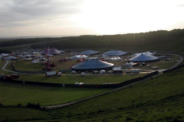
1066:== {{int:filedesc}} == {{Information |description={{en|1=Homelands festival at the foot of Cheesefoot Head. About 30,000 people turned up for the 17-hour dance marathon, beginning Saturday lunchtime. This was taken about 06:00 Sunday morning as people wer
83:
51:
126:
Homelands festival at the foot of
Cheesefoot Head. About 30,000 people turned up for the 17-hour dance marathon, beginning Saturday lunchtime. This was taken about 06:00 Sunday morning as people were beginning to drift
407:– You must give appropriate credit, provide a link to the license, and indicate if changes were made. You may do so in any reasonable manner, but not in any way that suggests the licensor endorses you or your use.
229:
279:
681:
637:
593:
689:
697:
490:
970:
906:
902:
838:
834:
685:
677:
589:
498:
494:
486:
796:
701:
693:
633:
482:
705:
502:
1059:
1048:
1043:
42:
640:"}},"text\/plain":{"en":{"P275":"Creative Commons Attribution-ShareAlike 2.0 Generic"}}}}": -->
708:"}},"text\/plain":{"en":{"P973":"https:\/\/www.geograph.org.uk\/photo\/15114"}}}}": -->
505:"}},"text\/plain":{"en":{"P2699":"https:\/\/www.geograph.org.uk\/profile\/8"}}}}": -->
731:
663:
619:
289:
239:
766:
324:
1116:
This file contains additional information, probably added from the digital camera or scanner used to create or digitize it.
414:
546:
980:
947:
920:
879:
852:
744:
715:
603:
567:
554:
539:
1085:
806:
774:
759:
647:
512:
471:
370:
1119:
If the file has been modified from its original state, some details may not fully reflect the modified file.
413:– If you remix, transform, or build upon the material, you must distribute your contributions under the
331:
on the
Geograph website for the photographer's contact details. The copyright on this image is owned by
596:"}},"text\/plain":{"en":{"P6216":"copyrighted"}}}}": -->
1076:
The following pages on the
English Knowledge use this file (pages on other projects are not listed):
913:"}},"text\/plain":{"en":{"P7787":"45 degree"}}}}": -->
845:"}},"text\/plain":{"en":{"P7787":"45 degree"}}}}": -->
91:
184:
1080:
367:
168:
781:
751:
8:
574:
311:
295:
245:
336:
78:
461:
116:
Homelands festival at the foot of
Cheesefoot Head - geograph.org.uk - 15114.jpg
52:
Homelands_festival_at_the_foot_of_Cheesefoot_Head_-_geograph.org.uk_-_15114.jpg
147:
990:
930:
862:
816:
725:
657:
613:
522:
316:
157:
328:
1016:
Click on a date/time to view the file as it appeared at that time.
281:
231:
266:
51° 02′ 58″ N, 1° 14′ 47″ W
216:
51° 02′ 53″ N, 1° 14′ 55″ W
136:
66:
455:
Add a one-line explanation of what this file represents
1103:
1074:
1094:
1014:
90:
Commons is a freely licensed media file repository.
664:
Creative
Commons Attribution-ShareAlike 2.0 Generic
638:
Creative
Commons Attribution-ShareAlike 2.0 Generic
199:Homelands festival at the foot of Cheesefoot Head
180:Homelands festival at the foot of Cheesefoot Head
56:(640 × 426 pixels, file size: 33 KB, MIME type:
424:https://creativecommons.org/licenses/by-sa/2.0
71:
430:Creative Commons Attribution-Share Alike 2.0
348:
132:
113:
153:
142:
14:
910:
842:
706:https:\/\/www.geograph.org.uk\/photo\/15114
390:– to copy, distribute and transmit the work
1096:The following other wikis use this file:
503:https:\/\/www.geograph.org.uk\/profile\/8
782:https://www.geograph.org.uk/photo/15114
288:View this and other nearby images on:
238:View this and other nearby images on:
575:https://www.geograph.org.uk/profile/8
191:
102:
335:and is licensed for reuse under the
256:
206:
1007:
371:Attribution-Share Alike 2.0 Generic
359:
354:
339:Attribution-ShareAlike 2.0 license.
13:
1114:
1086:List of electronic music festivals
460:
454:
345:
322:
120:
103:
49:
1140:
1121:
459:
1075:
853:coordinates of the point of view
835:coordinates of the point of view
445:
401:Under the following conditions:
366:This file is licensed under the
358:
353:
347:
315:
294:
280:
272:
244:
230:
222:
70:
31:
21:
442:
121:
46:No higher resolution available.
1091:
1011:
732:file available on the internet
682:file available on the internet
441:
323:This image was taken from the
26:
1:
921:coordinates of depicted place
903:coordinates of depicted place
36:
1071:
767:Geograph Britain and Ireland
698:Geograph Britain and Ireland
540:object of statement has role
487:object of statement has role
467:Items portrayed in this file
307:
197:Martyn Pattison /
178:Martyn Pattison /
7:
1111:
271:
221:
10:
1145:
1100:Usage on www.wikidata.org
936:51°2'58.20"N, 1°14'47.40"W
868:51°2'52.76"N, 1°14'55.32"W
415:same or compatible license
110:
105:
1008:
16:
745:geograph.org.uk image ID
686:geograph.org.uk image ID
444:
381:
77:This is a file from the
41:
1065:
169:required by the license
135:
81:. Information from its
1044:03:19, 30 January 2010
329:this photograph's page
300:51.049500; -1.246500
250:51.047990; -1.248700
84:description page there
1081:Homelands (festival)
396:– to adapt the work
555:author name string
495:author name string
1132:
1131:
1092:Global file usage
1069:
912:
844:
648:copyright license
634:copyright license
453:
344:
343:
327:collection. See
305:
304:
255:
254:
204:
203:
172:
99:
98:
79:Wikimedia Commons
32:Global file usage
1136:
1122:
1056:
1018:
958:
957:
952:
890:
889:
884:
784:
779:
775:described at URL
769:
764:
754:
749:
702:described at URL
604:copyright status
590:copyright status
577:
572:
562:
559:
549:
544:
451:
437:
434:
431:
428:
425:
417:as the original.
379:
368:Creative Commons
362:
361:
357:
356:
351:
350:
337:Creative Commons
325:Geograph project
319:
312:
301:
298:
284:
283:
277:
276:
275:
269:
268:
257:
251:
248:
234:
233:
227:
226:
225:
219:
218:
207:
166:
138:
125:
117:
111:
95:
74:
73:
67:
61:
59:
1144:
1143:
1139:
1138:
1137:
1135:
1134:
1133:
1110:
1090:
1077:
1070:
1062:
1054:
1010:
1009:
1006:
1005:
1004:
1003:
1002:
1001:
1000:
999:
997:
987:
986:
985:
983:
968:
967:
966:
965:
964:
963:
962:
961:
960:
959:
955:
953:
950:
941:
940:
939:
937:
927:
926:
925:
923:
900:
899:
898:
897:
896:
895:
894:
893:
892:
891:
887:
885:
882:
873:
872:
871:
869:
859:
858:
857:
855:
832:
831:
830:
829:
828:
827:
826:
825:
823:
813:
812:
811:
809:
794:
793:
792:
791:
790:
789:
788:
787:
786:
785:
780:
777:
771:
770:
765:
762:
756:
755:
750:
747:
738:
737:
736:
734:
722:
721:
720:
718:
675:
674:
673:
672:
671:
670:
669:
668:
666:
654:
653:
652:
650:
631:
630:
629:
628:
627:
626:
625:
624:
622:
610:
609:
608:
606:
587:
586:
585:
584:
583:
582:
581:
580:
579:
578:
573:
570:
564:
563:
561:Martyn Pattison
560:
557:
551:
550:
545:
542:
533:
532:
531:
529:
519:
518:
517:
515:
480:
479:
478:
477:
476:
474:
458:
457:
456:
439:
438:
435:
432:
429:
426:
423:
422:
380:
378:Martyn Pattison
377:
374:
363:
340:
333:Martyn Pattison
310:
299:
273:
264:
263:
260:Object location
249:
223:
214:
213:
210:Camera location
205:
194:
187:
175:
158:Martyn Pattison
148:geograph.org.uk
128:
115:
108:
101:
100:
89:
88:
87:is shown below.
63:
57:
55:
48:
47:
12:
11:
5:
1142:
1130:
1129:
1126:
1113:
1109:
1108:
1107:
1106:
1093:
1089:
1088:
1083:
1073:
1068:
1067:
1064:
1060:
1057:
1051:
1046:
1041:
1037:
1036:
1033:
1030:
1027:
1024:
1021:
1013:
998:
995:
993:
992:
991:
989:
988:
984:
979:
977:
976:
975:
974:
972:
946:
945:
944:
943:
942:
938:
935:
933:
932:
931:
929:
928:
924:
919:
917:
916:
915:
914:
908:
904:
878:
877:
876:
875:
874:
870:
867:
865:
864:
863:
861:
860:
856:
851:
849:
848:
847:
846:
840:
836:
824:
821:
819:
818:
817:
815:
814:
810:
805:
803:
802:
801:
800:
798:
773:
772:
758:
757:
743:
742:
741:
740:
739:
735:
730:
728:
727:
726:
724:
723:
719:
716:source of file
714:
712:
711:
710:
709:
707:
703:
699:
695:
691:
687:
683:
679:
678:source of file
667:
662:
660:
659:
658:
656:
655:
651:
646:
644:
643:
642:
641:
639:
635:
623:
618:
616:
615:
614:
612:
611:
607:
602:
600:
599:
598:
597:
595:
591:
566:
565:
553:
552:
538:
537:
536:
535:
534:
530:
527:
525:
524:
523:
521:
520:
516:
511:
509:
508:
507:
506:
504:
500:
496:
492:
488:
484:
475:
470:
468:
465:
464:
463:
462:
450:
449:
446:
443:
421:
420:
419:
418:
408:
399:
398:
397:
391:
384:You are free:
375:
365:
364:
346:
342:
341:
320:
309:
306:
303:
302:
292:
286:
261:
253:
252:
242:
236:
211:
202:
201:
195:
192:
189:
188:
183:
176:
173:
161:
160:
155:
151:
150:
144:
140:
139:
134:
130:
129:
118:
109:
107:
104:
97:
96:
75:
65:
64:
45:
40:
39:
34:
29:
24:
19:
9:
6:
4:
3:
2:
1141:
1127:
1124:
1123:
1120:
1117:
1105:
1102:
1101:
1099:
1098:
1097:
1087:
1084:
1082:
1079:
1078:
1063:
1058:
1052:
1050:
1047:
1045:
1042:
1039:
1038:
1034:
1031:
1028:
1025:
1022:
1020:
1019:
1017:
994:
982:
978:
949:
934:
922:
918:
881:
866:
854:
850:
820:
808:
804:
783:
776:
768:
761:
753:
746:
733:
729:
717:
713:
665:
661:
649:
645:
621:
617:
605:
601:
576:
569:
556:
548:
541:
526:
514:
510:
473:
469:
466:
447:
440:
427:CC BY-SA 2.0
416:
412:
409:
406:
403:
402:
400:
395:
392:
389:
386:
385:
383:
382:
376:Attribution:
372:
369:
352:
338:
334:
330:
326:
321:
318:
314:
313:
297:
293:
291:
290:OpenStreetMap
287:
285:
267:
262:
259:
258:
247:
243:
241:
240:OpenStreetMap
237:
235:
217:
212:
209:
208:
200:
196:
190:
186:
182: /
181:
177:
170:
165:
163:
162:
159:
156:
152:
149:
145:
141:
131:
124:
119:
112:
93:
86:
85:
80:
76:
69:
68:
62:
53:
44:
38:
35:
33:
30:
28:
25:
23:
20:
18:
15:
1118:
1115:
1095:
1015:
1012:File history
547:photographer
491:photographer
410:
404:
393:
387:
332:
270:
220:
198:
185:CC BY-SA 2.0
179:
122:
92:You can help
82:
50:
22:File history
1061:GeographBot
822:29 May 2005
620:copyrighted
594:copyrighted
411:share alike
405:attribution
164:Attribution
137:29 May 2005
114:Description
1125:_error
1072:File usage
1053:640 × 426
1029:Dimensions
996:image/jpeg
981:media type
971:media type
528:some value
58:image/jpeg
27:File usage
1104:Q16994230
1026:Thumbnail
1023:Date/Time
807:inception
797:inception
308:Licensing
193:InfoField
174:InfoField
123:English:
1112:Metadata
760:operator
694:operator
448:Captions
394:to remix
388:to share
373:license.
37:Metadata
1055:(33 KB)
1040:current
1035:Comment
948:heading
907:heading
880:heading
839:heading
513:creator
483:creator
472:depicts
452:English
106:Summary
54:
956:degree
911:degree
888:degree
843:degree
278:
228:
154:Author
143:Source
752:15114
690:15114
146:From
127:home.
1032:User
436:true
433:true
133:Date
17:File
954:45
886:45
568:URL
499:URL
951::
883::
778::
763::
748::
571::
558::
543::
1128:0
171:)
167:(
94:.
60:)
Text is available under the Creative Commons Attribution-ShareAlike License. Additional terms may apply.
_heading:45.00&language=en)
_heading:45.00&language=en)
